![]() Ordinary Meeting of Council
Ordinary Meeting of Council
Wednesday 1 December 2021
4.00pm
Council Chambers
209 Comur Street, Yass
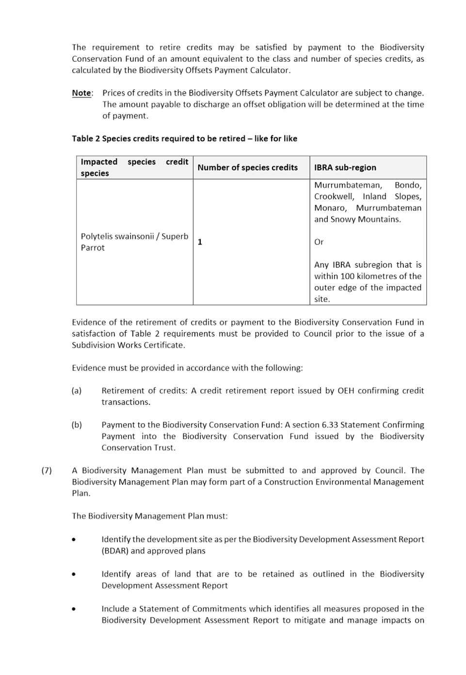
![]() Ordinary Meeting of Council
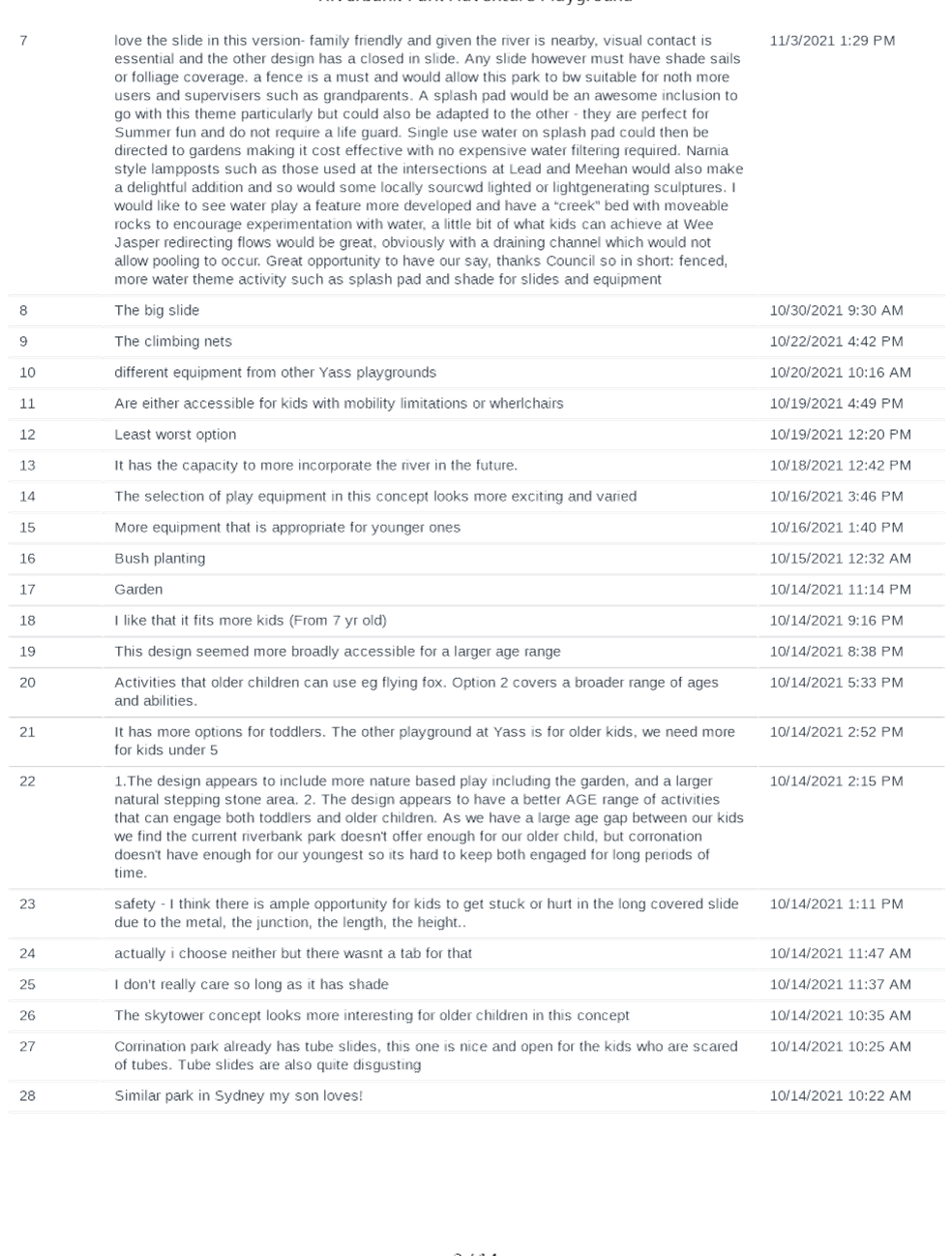
Ordinary Meeting of Council
Wednesday 1 December 2021
4.00pm
Council Chambers
209 Comur Street, Yass
|
PRAYER:
All Stand:
Mayor: Let us be still and remember the presence of God. As we commence our meeting let us together pray for guidance and help.
All say together:
Almighty God, we ask your blessing upon this Council.
Direct and prosper our deliberations to the true welfare of Australia and the people of Yass Valley Amen.
|
FUTURE MEETINGS
|
January 2022
Wednesday 12th 2.00pm Ordinary Meeting of Council
|
Ordinary Meeting of Council
Open Forum Page No.
Webcasting
This meeting is being webcast, a reminder to those in attendance that you should refrain from making any defamatory statements.
Acknowledgement of Country
I acknowledge that we are meeting on the ancestral land of the Ngunnawal people. I recognise the Ngunnawal as the traditional custodians and pay respect to the Elders of the community and their descendants.
1. Prayer
2. Apologies
3. Declaration of Pecuniary Interests/Special Disclosures
4. Confirmation of Minutes
Minutes of Ordinary Council Meeting held on 27 October 2021............. 5
Minutes of Extraordinary Council Meeting held on 1 November 2021.. 30
6. Director of Planning & Environment Reports
6.1 Victoria Park Masterplan................................................ 34
6.2 Crown Lands Miscellaneous Reserves Draft Plan of Management................................................................. 58
6.3 Climate Change and Natural Disaster Risk Assessment..... 61
6.4 Development Consent No 2000049 - 101 Lot Subdivision, Isabel Drive, Murrumabteman........................................ 62
6.5 Development Consent No DA175279 - Preschool, 37 Church Street, Yass.................................................................. 110
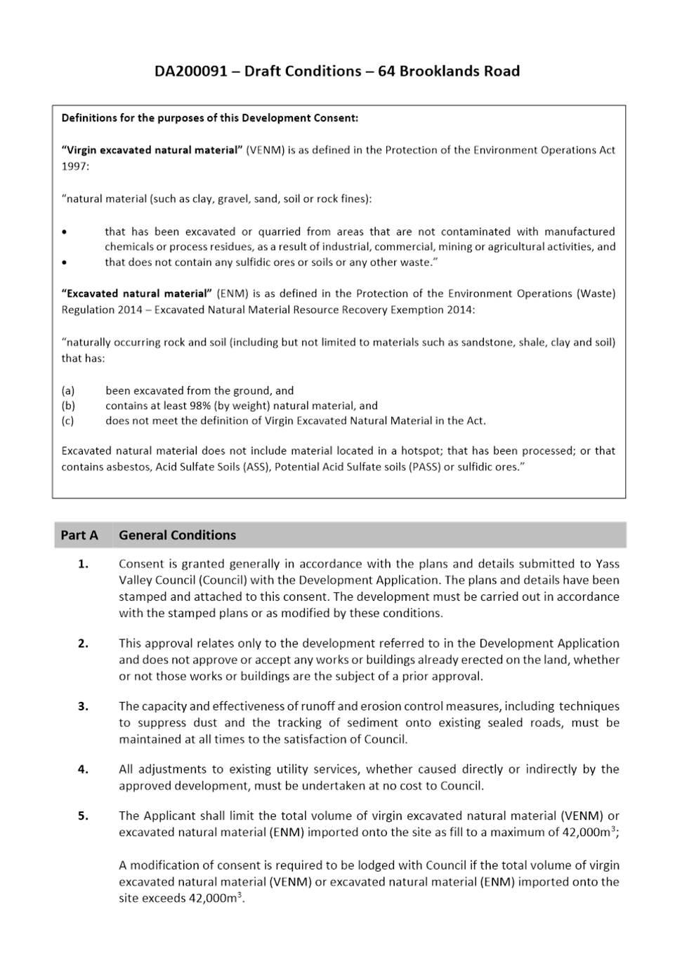
6.6 Development Application DA200091 - Eroision Gully Rehabilitation and importation of material - 64 Brooklands Road, Wallaroo............................................................ 146
6.7 Alcohol Free Zone......................................................... 177
7. Director of Infrastructure & Assets Reports
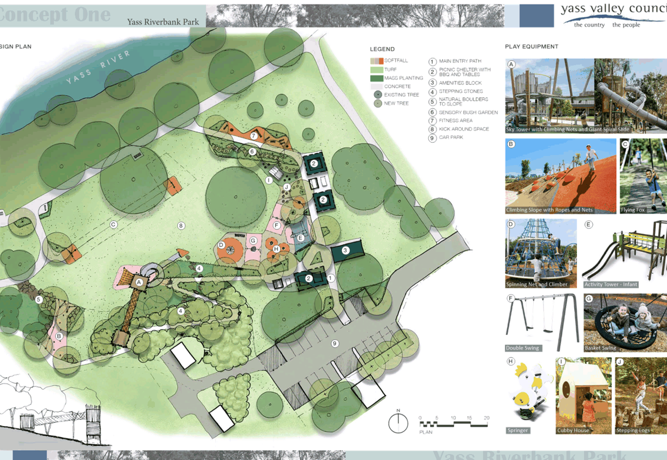
7.1 Riverbank Park Adventure Playground........................... 188
7.2 Yass Water Treatment Plant Upgrade Project Update..... 206
7.3 Lease Request - Former Pool Manager's House.............. 208
8. Director of Corporate & Community Reports
8.1 Annual Financial Statements 2020/21............................ 219
8.2 2020/21 Annual Report................................................ 222
8.3 2017-2021 End of Term Report..................................... 223
8.4 Investment and Borrowings Report - October 2021........ 243
8.5 Sale of Land for Unpaid Rates........................................ 247
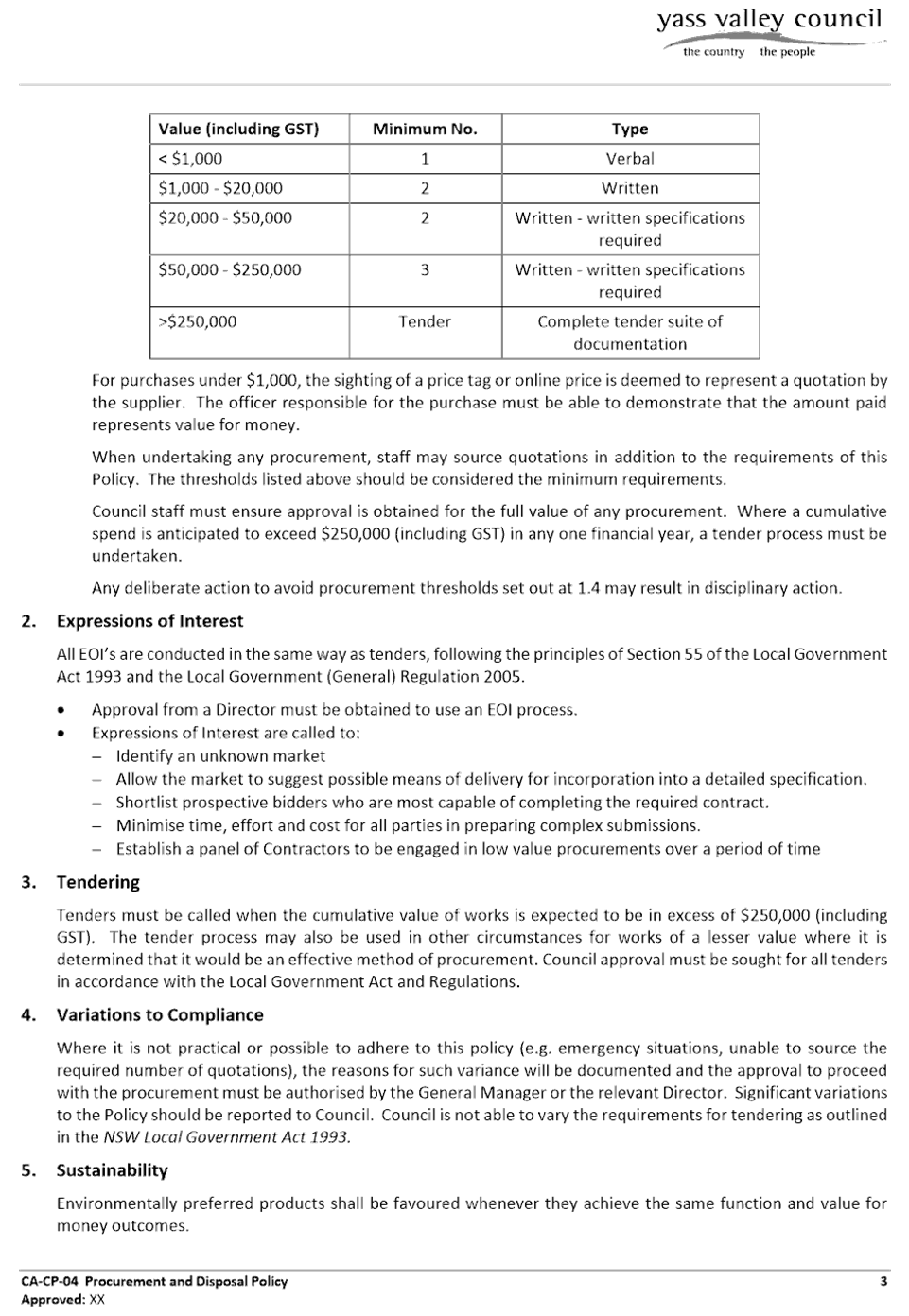
8.6 Draft Procurement & Disposal Policy............................. 249
8.7 Draft Councillor Expenses & Facilities Policy................... 259
8.8 Code of Meeting Practice.............................................. 270
9.1 Local Government NSW Special Conference Motion - Streetlighting............................................................... 314
9.2 Guidelines for Advisory Committees & Committees of Council........................................................................ 316
Nil
11.1 Southern Phone Reserve............................................... 319
12. Minutes and Recommendations of Council Committees
12.1 Minutes of the Canberra Region Joint Organisation held on 29 October 2021.......................................................... 323
12.2 Minutes of the Country Mayors Association AGM and General Meetings held on 5 November 2021................. 334
12.3 Minutes of the Traffic Facilities Committee held on 3 November 2021........................................................... 346
Nil
Close of Meeting Time
Chris Berry
GENERAL MANAGER
Minutes of the
Ordinary Meeting of Council
Wednesday 27 October 2021
4.00pm
Council Chambers
209 Comur Street, Yass
Table of Contents
1. Prayer
2. Apologies
3. Declaration of Interest/Disclosures
4. Confirmation of Minutes
5. Mayoral Minute
6. Director of Planning & Environment Reports
6.1 Open Space Strategy & Yass Main Street Masterplan Project Committees
6.2 Draft Housing Issues Paper
6.3 Planning Proposal - 2402 Sutton Road, Sutton
6.4 Energy from Waste Infrastructure Plan
6.5 Deferred Development and Headworks Contributions
6.6 Variations to Development Standards Quarterly Report
7. Director of Infrastructure & Assets Reports
7.3 Permanent Road Closure Telegraph Close
7.1 Fixing Local Roads Grant Program - Round 3
7.2 Request to Lease Part Road Reserve - Southwell Road, Wallaroo
7.4 Permanent Partial Road Closure of Old Yass Boorowa Road, Kangiara. 9
7.5 Yass Valley Development Contributions Plan 2018 - Review of Operation
7.6 Walker Park - Request for Annual Usage Fee Waiver
7.7 Coronation Park Miracle Slide
7.8 Additional Spaces Allocation Request - Tesla Electric Vehicle Charging Station Park and Ride
7.9 2021/22 School Zone Infrastructure Sub-Program Grant
8. Director of Corporate & Community Reports
8.1 Rates Arrears
8.2 Investment and Borrowings Report - September 2021
8.3 1st Quarter Budget Review 2021/22
8.4 Library Overdue Fines
9. General Manager Reports
9.1 Tender Evaluation - Murrumbateman Road Safety Upgrade - YVC.IA.36.2021
9.2 Tender Evaluation - Safety Around Schools - YVC.IA.37.2021
9.3 Tender Evaluation - Bango Bridge Replacement - YVC.IA.25.2021 & RFT2021/31
9.4 Procurement Evaluation - Commercial Waste Collection Vehicle - YVC-IA-14-2021
9.5 Laidlaw Street Sewage Pump Station
9.6 Local Government Election 2021
9.7 Christmas/New Year Opening Hours
9.8 Yass Water Treatment Plant Upgrade: Stage 1 Construction - Project Management Support
10. Notice of Motion
11. Questions with Notice
12. Minutes and Recommendations of Council Committees
12.1 Minutes of the Audit, Risk & Improvement Committee held on 28 September 2021
12.2 Minutes of the Yass Soldiers Memorial Hall Committee held on 7 October 2021
13. Confidential Matters
13.1 Laidlaw Street Sewage Pump Station
13.2 Tender Evaluation - Murrumbateman Road Safety Upgrades - YVC.IA.36.2021
13.3 Tender Evaluation - Safety Around Schools - YVC.IA.37.2021
13.4 Tender Evaluation - Bango Bridge Replacement - YVC.IA.25.2021 & RFT2021/31
13.5 Procurement Evaluation - Commercial Waste Collection Vehicle - YVC-IA-14-2021
13.6 Yass Water Treatment Plant Upgrade: Stage 1 Construction - Project Management Support
Presentations to Council – Items on the Meeting Agenda
· Ross Webster
Item 7.6 Walker Park Request for Annual Usage Fee Waiver
· Kat McGlip- - Ginninderra Catchment Group
Item 7.2 Request to Lease Part Road Reserve – Southwell Road, Wallaroo
Council Meeting - The Mayor declared the meeting open at 4.28 pm.
Present
Councillors Rowena Abbey, Mayor, in the chair, Cecil Burgess, Geoff Frost, Nathan Furry, Allison Harker, Jasmin Jones, Michael McManus, Mike Reid and Kim Turner.
Also present were the General Manager – Chris Berry, Director Planning & Environment – Julie Rogers, Director Infrastructure & Assets – James Dugdell, Director Corporate & Community – Lynette Safranek and Corporate Planning & Executive Support Officer – Shirree Garland.
Acknowledgement of Country
1. Prayer
2. Apologies
Nil
3. Declaration of Interest/Disclosures
Councillor Abbey declared a pecuniary conflict of interest in Item 6.5 Deferred Development and Head Works contributions and stated that she believed her interest would preclude her from voting.
Reason: Councillor Abbey declared an interest as Director of SELX and Yass Industrial Park.
Councillor Abbey declared a pecuniary conflict of interest in Item 7.3 Permanent Road Closure Telegraph Close and stated that she believed her interest would preclude her from voting.
Reason: Councillor Abbey declared an interest as the Director of Bellevale Cattle Co PtyLtd.
Councillor Burgess declared a non-significant, non-pecuniary conflict of interest in Item 7.1 Fixing Local Roads Grant Program – Round 3 and stated that he did not believe his interest would preclude him from voting.
Reason: Councillor Burgess declared an interest as he is owns property on Back Creek Road but not in the vicinity of the proposed works.
Councillor Harker declared a non-significant, non-pecuniary conflict of interest in Item 7.2 Request to Lease Part Road Reserve – Southwell Road Wallaroo and stated that she did not believe her interest would preclude her from voting.
Reason: Councillor Harker declared an interest as she is the current acting Chair of Local Land Services.
4. Confirmation of Minutes
|
RESOLVED that the minutes of the Ordinary Council Meeting held on 22 September 2021 covered resolution numbers 186-207 inclusive, be taken as read and confirmed. (Furry/Burgess) 208 |
FOR: Councillors R Abbey, C Burgess, G Frost, N Furry, A Harker, J Jones, M McManus, M Reid and K Turner
AGAINST: Nil
FOR: Councillors R Abbey, C Burgess, G Frost, N Furry, A Harker, J Jones, M McManus, M Reid and K Turner
AGAINST: Nil
6. Director of Planning & Environment Reports
FOR: Councillors R Abbey, C Burgess, G Frost, N Furry, A Harker, J Jones, M McManus, M Reid and K Turner
AGAINST: Nil
FOR: Councillors R Abbey, C Burgess, G Frost, N Furry, A Harker, J Jones, M McManus, M Reid and K Turner
AGAINST: Nil
FOR: Councillors R Abbey, C Burgess, G Frost, N Furry, A Harker, J Jones, M McManus, M Reid and K Turner
AGAINST: Nil
|
RESOLVED that : 1. Council states its total opposition to waste incineration facilities in the Yass Valley Local Government Area and neighbouring Local Government Areas. Council’s position is to ensure that environmental and public health outcomes are the number one priority. 2. The State Government be requested to undertake an urgent review be undertaken of the Energy from Waste Infrastructure Plan before any applications for specific Energy from Waste proposals are lodged or determined based on: · A robust evaluation of the technology used in any existing facilities in addressing any adverse impacts (especially emissions). · A cost benefit analysis of the best technology facility in comparison to other energy generating alternatives. · Identifying potential sites and evaluating their suitability based on the preferred technology. · Use of an Environmental Impact Assessment process to evaluate specific proposals and a merits based review process for those aggrieved by the assessment outcomes.+ 3. The Minister for Environment and Local Member for Goulburn be advised of Council’s determination. (Furry/Reid) 213 |
FOR: Councillors R Abbey, C Burgess, G Frost, N Furry, A Harker, J Jones, M McManus, M Reid and K Turner
AGAINST: Nil
|
Motion |
|
RESOLVED that Item 7.3 Permanent Road Closure Telegraph Close be brought forward. (McManus/Harker) 214 |
FOR: Councillors R Abbey, C Burgess, G Frost, N Furry, A Harker, J Jones, M McManus, M Reid and K Turner
AGAINST: Nil
At 05:06 pm Councillor Abbey left the Chambers.
Deputy Mayor, Councillor Furry took the chair.
FOR: Councillors C Burgess, G Frost, N Furry, A Harker, J Jones, M McManus, M Reid and K Turner
AGAINST: Nil
FOR: Councillors R Abbey, C Burgess, G Frost, N Furry, A Harker, J Jones, M McManus, M Reid and K Turner
AGAINST: Nil
7. Director of Infrastructure & Assets Reports
|
7.3 Permanent Road Closure Telegraph Close
|
|
SUMMARY Development Consent DA135127 has been issued for the subdivision of 42 Bellevale Road, Yass, Lot 1 DP1272213. Council has received a modification request for Consent DA135127, which includes Permanent Road Closure of Telegraph Close.
|
|
1. The road closure of Telegraph Close, Yass be approved. 2. The road closure process be commenced and notification be undertaken in accordance with the Roads Act 1993. 3. The closed road be dedicated as Operational Land under the Local Government Act 1993 and be sold to the adjacent landowner at the unimproved land value. 4. The General Manager and Mayor be authorised to sign documentation associated with the partial road closure. (Frost/Jones) 217 |
FOR: Councillors R Abbey, C Burgess, G Frost, N Furry, A Harker, J Jones, M McManus, M Reid and K Turner
AGAINST: Nil
|
RESOLVED that: 1. The unused part of Southwell Road adjacent to No 225 is not deemed to be surplus to requirement but is prepared to enter into a temporary short term lease with the applicant. 2. All submitters be thanked and advised of the decision. 3. The suggestion by the Ginninderra Catchment Group to revegetate the road reserve be declined at this stage and that the Group be asked to reapply once the Policy Framework has been adopted. 4. A policy framework be developed regarding the undertaking of revegetation works in a road reserve. (Jones/Burgess) 219 |
FOR: Councillors R Abbey, C Burgess, G Frost, N Furry, A Harker, J Jones, M McManus, M Reid and K Turner
AGAINST: Nil
FOR: Councillors R Abbey, C Burgess, G Frost, N Furry, A Harker, J Jones, M McManus, M Reid and K Turner
AGAINST: Nil
|
7.5 Yass Valley Development Contributions Plan 2018 - Review of Operation
|
|
SUMMARY The Yass Valley Development Contributions Plan 2018 has now been in operation since 27 March 2019. Council staff have recently undertaken a review of the operations of the Plan and will recommended a number of administrative changes to improve the operations and accountability built into the Plan.
|
|
RESOLVED that the Yass Valley Development Contributions Plan 2018 be amended to incorporate the administrative changes identified in this report and placed on public exhibition. (Furry/Burgess) 221 |
FOR: Councillors R Abbey, C Burgess, G Frost, N Furry, A Harker, J Jones, M McManus, M Reid and K Turner
AGAINST: Nil
|
FORESHADOWED MOTION |
|
That : 1. The work undertaken for ground renovation at Walker Park by Yass United Rugby League Football Club & Yass Touch Football Association be acknowledged and the clubs be thanked for their continued contribution to the development of sporting fields for their benefit as well as the benefit for the whole community. 2. An audit of service levels for all Council managed community sporting facilities and recalculation of user fees and charges be undertaken in early 2022 prior to setting Council’s Operational Plan. (Frost/ |
|
RESOLVED That: 1. Yass High School be thanked for their work to date to convert the miracle slide into an art piece. 2. Expressions of Interest be sought for an individual or group for the miracle slide and if no appropriate Interest is received the miracle slide be disposed of and a history board be installed at Coronation Park. (Jones/Turner) 224 |
|
FOR: Councillors R Abbey, C Burgess, G Frost, N Furry, A Harker, J Jones, M McManus, M Reid and K Turner AGAINST: Nil |
FOR: Councillors R Abbey, C Burgess, N Furry, A Harker, J Jones, M McManus, M Reid and K Turner
AGAINST: Councillor G Frost
FOR: Councillors R Abbey, C Burgess, G Frost, N Furry, A Harker, J Jones, M McManus, M Reid and K Turner
AGAINST: Nil
8. Director of Corporate & Community Reports
|
|
|
SUMMARY This report provides Council with an update on rate arrears as at 30 September 2021. Rate arrears totalled $1,241,261.36 as of 30 June 2021 and has been reduced to $1,027,357.95 as of 30 September 2021, being a reduction of $213,903.41 or 17.23 %.
|
|
1. The report on rates arrears be noted. 2. Sale of land for unpaid rates, to be auctioned on 17 November 2021, to be considered in Closed Council. (Frost/Turner) 227 |
|
FOR: Councillors R Abbey, C Burgess, G Frost, N Furry, A Harker, J Jones, M McManus, M Reid and K Turner AGAINST: Nil |
FOR: Councillors R Abbey, C Burgess, G Frost, N Furry, A Harker, J Jones, M McManus, M Reid and K Turner
AGAINST: Nil
|
8.3 1st Quarter Budget Review 2021/22
|
|
.SUMMARY This report represents the first 2021-22 Quarterly Budget Review Statements (QBRS) for the period 1 July to 30 September 2021. Council’s projected year end net operating result before capital is expected to decrease from a budgeted surplus of $32k to a budgeted deficit of $349k for 2021/22 financial year.
|
|
1. The Quarterly Budget Review Statements adjustments, as detailed in the attachments, be adopted and the relevant income and expenditure budget adjustments be approved. 2. In accordance with the Local Government (General) Regulation (NSW) Clause 203 (2)(a), Council’s financial position as at 30 September 2021 is satisfactory, having regard to revised projected estimates of income and expenditure, and the original budgeted income and expenditure. (Frost/Furry) 229 |
FOR: Councillors R Abbey, C Burgess, G Frost, N Furry, A Harker, J Jones, M McManus, M Reid and K Turner
AGAINST: Nil
FOR: Councillors R Abbey, C Burgess, G Frost, N Furry, A Harker, J Jones, M McManus, M Reid and K Turner
AGAINST: Nil
9. General Manager Reports
FOR: Councillors R Abbey, C Burgess, G Frost, N Furry, A Harker, J Jones, M McManus, M Reid and K Turner
AGAINST: Nil
FOR: Councillors R Abbey, C Burgess, G Frost, N Furry, A Harker, J Jones, M McManus, M Reid and K Turner
AGAINST: Nil
|
9.3 Tender Evaluation - Bango Bridge Replacement - YVC.IA.25.2021 & RFT2021/31
|
|
SUMMARY This report provides advice and recommendations on the submission of tenders for the Bango Bridge Replacement project, funded by the Fixing Country Bridges grant program and Yass Valley Council, under contract YVC.IA.25.2021 and RFT2021/31.
|
|
RESOLVED that item be classified CONFIDENTIAL in accordance with Section 10A(2)(di) of the Local Government Act 1993, which permits the meeting to be closed to the public for business relating to commercial information of a confidential nature that would, if disclosed, prejudice the commercial position of the person who supplied. (Furry/Turner) 233 |
FOR: Councillors R Abbey, C Burgess, G Frost, N Furry, A Harker, J Jones, M McManus, M Reid and K Turner
AGAINST: Nil
FOR: Councillors R Abbey, C Burgess, G Frost, N Furry, A Harker, J Jones, M McManus, M Reid and K Turner
AGAINST: Nil
|
RESOLVED that item is classified CONFIDENTIAL in accordance with Section 10A(2)(c and di) of the Local Government Act 1993, which permits the meeting to be closed to the public for business relating to information that would, if disclosed, confer a commercial advantage on a person with whom the Council is conducting (or proposes to conduct) business and commercial information of a confidential nature that would, if disclosed prejudice the commercial position of the person who supplied it. (Furry/Turner) 235 |
FOR: Councillors R Abbey, C Burgess, G Frost, N Furry, A Harker, J Jones, M McManus, M Reid and K Turner
AGAINST: Nil
FOR: Councillors R Abbey, C Burgess, G Frost, N Furry, A Harker, J Jones, M McManus, M Reid and K Turner
AGAINST: Nil
|
9.7 Christmas/New Year Opening Hours
|
|
SUMMARY To present a report on the Christmas/New Opening Hours for 2021/22 and the arrangements for various Council services.
|
|
RESOLVED that all Council services be closed from close of business on Thursday 23 December 2021 until Tuesday 4 January 2022, other than the following: · Swimming Pools – open other than Christmas Day and Boxing Day · Yass Valley Information Centre - open other than Christmas Day · Waste Transfer Stations – open other than Christmas Day and New Year’s Day · Waste Collections – collections scheduled for Christmas Day will be collected on an alternate day with customers advised in the week prior to Christmas. Collections on other public holidays will proceed as normal · Roads and Maintenance Services– skeleton crews will be maintained to attend to service needs and emergencies · Water and Wastewater - skeleton crews will be maintained to attend to service needs and emergencies · Duty Officer – an on-call duty officer will be maintained over the entire period (Frost/Reid) 237 |
FOR: Councillors R Abbey, C Burgess, G Frost, N Furry, A Harker, J Jones, M McManus, M Reid and K Turner
AGAINST: Nil
FOR: Councillors R Abbey, C Burgess, G Frost, N Furry, A Harker, J Jones, M McManus, M Reid and K Turner
AGAINST: Nil
10. Notice of Motion
Nil
11. Questions with Notice
Nil
12. Minutes and Recommendations of Council Committees
FOR: Councillors R Abbey, C Burgess, G Frost, N Furry, A Harker, J Jones, M McManus, M Reid and K Turner
AGAINST: Nil
Note: EOI for the Creative Capital Program closing date extended to 17 November 2021.
FOR: Councillors R Abbey, C Burgess, G Frost, N Furry, A Harker, J Jones, M McManus, M Reid and K Turner
AGAINST: Nil
13. Confidential Matters
FOR: Councillors R Abbey, C Burgess, G Frost, N Furry, A Harker, J Jones, M McManus, M Reid and K Turner
AGAINST: Nil
Closed Council commenced at 6.58 pm.
|
13.1 Laidlaw Street Sewage Pump Station
|
|
SUMMARY This report provides information and seeks approval for a proposal to make provisions in the new sewage pump station (Yarrah SPS1) to be constructed as part of the Stage 1 Yarrah development to allow for future decommissioning of Laidlaw Street Sewage Pump Station.
|
|
RESOLVED that : 1. Design and construction of Yarrah SPS 1 to make provisions to receive load from existing Laidlaw Sewage Pump Station (SPS) to enable future decommissioning of Laidlaw Street SPS be approved. 2. The General Manager be delegated to execute the Deed of Agreement with WMD Holdings to design and construct the Yarrah SPS1 to include the load from the Laidlaw Street SPS. 3. An allocation be made from the s64 Sewer Network Reserve to the 2021/22 Operational Plan and Budget to make these provisions following completion of negotiations. (Furry/Reid) 242 |
FOR: Councillors R Abbey, C Burgess, G Frost, N Furry, A Harker, J Jones, M McManus, M Reid and K Turner
AGAINST: Nil
|
13.2 Tender Evaluation - Murrumbateman Road Safety Upgrades - YVC.IA.36.2021
|
|
SUMMARY This report provides advice and recommendations on the submission of tenders for the Murrumbateman road Safety Upgrade, funded by the Federal Government Black Spot 2021/22 grant program, under contract YVC.IA.36.2021.
|
|
1. The tender submitted by Denrith Pty Ltd under the Murrumbateman Road Safety Upgrades be accepted for a total cost of $293,085.50 excluding GST; 2. The units rates submitted by Denrith Pty Ltd as part of their tender submission to undertake additional safety works on Murrumbateman Road to the maximum grant funding amount in accordance with the conditions of the grant. (Burgess/Reid) 243 |
FOR: Councillors R Abbey, C Burgess, G Frost, N Furry, A Harker, J Jones, M McManus, M Reid and K Turner
AGAINST: Nil
|
13.3 Tender Evaluation - Safety Around Schools - YVC.IA.37.2021
|
|
SUMMARY This report provides advice and recommendations on the submission of tenders for the Safety around Schools project funded by the Federal and State Governments Road Safety Program, School Zone Infrastructure Sub Program, under contract YVC.IA.37.2021.
|
|
1 the tender submitted by Denrith Pty Ltd under the Safety around Schools Tender for Sutton Pedestrian Refuge; Bywong Street be accepted for a total cost of $56,540 exc GST; 2. That the tender submitted by Denrith Pty Ltd under the Safety around Schools Tender for Berinba School Connectivity Upgrade; Grand Junction Road/Morton Avenue be accepted for a total cost of $231,350 exc GST; 3. That the remaining two separable portions for Mt Carmel School Crossing upgrade (Rossi Street) and Gundaroo School parking upgrades (Lot Street) not be accepted and referred to staff to review the scope of works and then commence a new procurement process. (Furry/Harker) 244 |
FOR: Councillors R Abbey, C Burgess, G Frost, N Furry, A Harker, J Jones, M McManus, M Reid and K Turner
AGAINST: Nil
|
13.4 Tender Evaluation - Bango Bridge Replacement - YVC.IA.25.2021 & RFT2021/31
|
|
SUMMARY This report provides advice and recommendations on the submission of tenders for the Bango Bridge Replacement project, funded by the Fixing Country Bridges grant program and Yass Valley Council, under contract YVC.IA.25.2021 and RFT2021/31, and progressed as a joint procurement with Cootamundra-Gundagai Regional Council in accordance with the grant requirements.
|
|
1. The six tenders for the Replacement of Timber Road Bridges – Design and Construction of six Concrete Bridges were received, of which five were conforming be noted. 2. In accordance with Clause 178(1)(b) Local Government (General) Regulation 2021, the tenders be declined . 3. In accordance with Clause 178(3)(e) Local Government (General) Regulation 2021, negotiations be commenced with any person (whether or not the person was a tenderer) with a view to entering into a contract in relation to the subject matter of the tender. 4. In accordance with Clause 178(4)(a) Local Government (General) Regulation 2021, invitations for fresh tenders or applications is declined for the following reasons as referred to in subsection (3)(b)-(d) of the Regulation: • All submitted tenders exceeded the budgets allocated · A competitive outcome is required to satisfy constraints relating to the upcoming Local Government Election Caretaker Period 5. In accordance with Clause 178(4)(b) Local Government (General) Regulation 2021 the reasons for determining to enter into negotiations with the person or persons referred to in subsection (3)(e) of the Regulation are as follows: • In order
to achieve an appropriate outcome prior to the Local Government Election
Caretaker Period commencing and to deliver the best value outcome for both 6. The Tender Assessment Panel be authorised to negotiate with all tenderers and additional persons named in the body of the report. 7. Following the negotiation process, and the submission of recommendations from the Tender Evaluation Panel, the General Manager of Yass Valley be authorised to execute a contract for the Replacement of Timber Road Bridge – Design and Construction of one Concrete Bridge (Bango Lane) (YVC.IA.25.2021 and RFT2021/31). 8. All tenderers be advised of the Council decision. (Burgess/Harker) 245 |
FOR: Councillors R Abbey, C Burgess, G Frost, N Furry, A Harker, J Jones, M McManus, M Reid and K Turner
AGAINST: Nil
|
13.5 Procurement Evaluation - Commercial Waste Collection Vehicle - YVC-IA-14-2021
|
|
SUMMARY This report provides advice on the recent Request for Quotation for Contract YVC - IA - 14 – 2021, Supply and Delivery of a 14 tonne Commercial Waste Collection truck.
|
|
1. The quote submitted by Isuzu Australia Pty Ltd + Superior Pak under the Contract YVC – IA – 14 – 2021 be accepted for a total cost of $267,360 ex GST. 2. A future report be provided to Council to determine the best funding model once the vehicle is due for delivery in 6 to 9 months. (Turner/Furry) 246 |
FOR: Councillors R Abbey, C Burgess, G Frost, N Furry, A Harker, J Jones, M McManus, M Reid and K Turner
AGAINST: Nil
|
13.6 Yass Water Treatment Plant Upgrade: Stage 1 Construction - Project Management Support
|
|
SUMMARY This report provides information on the project management support required for the Yass Water Treatment Plant Upgrade Stage 1 Construction.
|
|
RESOLVED that engagement of Hunter H2O for design and business case development be retained and include project management service for Yass Water Treatment Plant Upgrade: Stage 1 Construction for a fee of $325,827.60 (GST inclusive). (Furry/Harker) 247 |
FOR: Councillors R Abbey, C Burgess, G Frost, N Furry, A Harker, J Jones, M McManus, M Reid and K Turner
AGAINST: Nil
SALE OF LAND FOR UNPAID RATES
A discussion was held in relation to the upcoming Auction on 17 November 2021, for the sale of land for unpaid rates. Properties to bid on were discussed and further information out of session is to be circulated to Councillors on the process of Council auctioning the properties for unpaid rates and making a bid on purchasing the properties.
|
RESOLVED that the meeting move into Open Council. (Furry/Harker) 248 |
FOR: Councillors R Abbey, C Burgess, G Frost, N Furry, A Harker, J Jones, M McManus, M Reid and K Turner
AGAINST: Nil
Open Council resumed at 7.45 pm.
|
RESOLVED that the recommendations in Closed Council be adopted. (Burgess/McManus) 249 |
FOR: Councillors R Abbey, C Burgess, G Frost, N Furry, A Harker, J Jones, M McManus, M Reid and K Turner
AGAINST: Nil
Minutes of the
Extraordinary Meeting of Council
Monday 1 November 2021
1.00pm
Council Chambers
209 Comur Street, Yass
Table of Contents
1. Apologies
2. Declaration of Interest/Disclosures
3. General Manager Reports
3.1 Sale of Land for Unpaid Rates
4. Confidential Matters
4.1 Sale of Land for Unpaid Rates
Extraordinary Council Meeting - The Mayor declared the meeting open at 1.05 pm.
Present
Councillors Rowena Abbey, Mayor, in the chair, Cecil Burgess (1.21pm), Geoff Frost, Nathan Furry (via Zoom), Allison Harker (via Zoom), Michael McManus (via Zoom), Mike Reid (via Zoom) and Kim Turner.
Also present were the General Manager – Chris Berry, Director of Infrastructure & Assets – James Dugdell, and Corporate Planning & Executive Support Officer – Shirree Garland.
1. Apologies
|
RESOLVED that apologies be received from Councillor Jones and leave of absence be granted. (Frost/Furry) 250 |
FOR: Councillors R Abbey, G Frost, N Furry, A Harker, M McManus, M Reid and K Turner
AGAINST: Nil
2. Declaration of Interest/Disclosures
3. General Manager Reports
FOR: Councillors R Abbey, G Frost, N Furry, A Harker, M McManus, M Reid and K Turner
AGAINST: Ni
4. Confidential Matters
FOR: Councillors R Abbey, G Frost, N Furry, A Harker, M McManus, M Reid and K Turner
AGAINST: Nil
Closed Council commenced at 1.06 pm.
|
4.1 Sale of Land for Unpaid Rates
|
|
SUMMARY To consider the sale of seven properties for unpaid rates under s713 Local Government Act 1993.
|
|
1. The General Manager and the Mayor are authorised to approach a suitable independent person to attend the Auction and bid on Council’s behalf. 2. The General Manager bid on properties that clearly have a public and community use. 3. The General Manager and the Mayor be authorised to sign all legal documentation. (Turner/McManus) 253 |
|
FOR: Councillors R Abbey, C Burgess, G Frost, N Furry, A Harker, M McManus, M Reid and K Turner AGAINST: Nil |
|
RESOLVED that the meeting move into Open Council. (Burgess/Reid) 254 |
FOR: Councillors R Abbey, C Burgess, G Frost, N Furry, A Harker, M McManus, M Reid and K Turner
AGAINST: Nil
Open Council resumed at 1.40 pm.
|
RESOLVED that the recommendations in Closed Council be adopted. (Reid/Burgess) 255 |
FOR: Councillors R Abbey, C Burgess, G Frost, N Furry, A Harker, M McManus, M Reid and K Turner
AGAINST: Nil
The
meeting closed at 1:41 p.m.![]()
![]()
Ordinary Council Meeting 1 December 2021
SUMMARY
To present the outcomes of the consultation for the draft Victoria Park Masterplan.
|
That the Victoria Park Masterplan be adopted and it form the basis of a Plan of Management under the Crown Land Management Act 2016 and Local Government Act 1993 |
Financial IMPLICATIONS
Funding was provided by NSW Crown Lands to support Council’s preparation of Plans of Management (POM). As a Masterplan will be used to inform the POM for Victoria Park it was agreed that the funding could be used for this purpose.
POlicy & Legislation
· Crown Lands Management Act 2016
· Local Government Act 1993
· Yass Valley Community Engagement Strategy
REPORT
1. Background
In July 2021 Council considered the draft masterplan for Victoria Park and determined to place it on public exhibition. It was prepared by landscape architects with input from internal Council stakeholders, the contract Caravan Park Managers, and key user groups including Yass Rams Rugby (Seniors and Juniors), Yass Cricket (Seniors and Juniors), Hume Tennis, Spinifex Tennis, Yass High School and Yass Little Athletics.
2. Public Exhibition & Submissions
Due to COVID-19 restrictions the planned consultation format (including drop-in sessions) had to be abandoned. However, the plan was still widely shared through printed posters placed around the park/riverbank paths as well as through Council’s website and social media from 30 August to 1 October 2021.
Ten submissions were received from individuals and on behalf of sporting groups (refer Attachment A). The issues raised and the responses are summarised as follows. In addition, there were suggestions about general inclusions or editing in the draft masterplan, most of which have been accommodated.
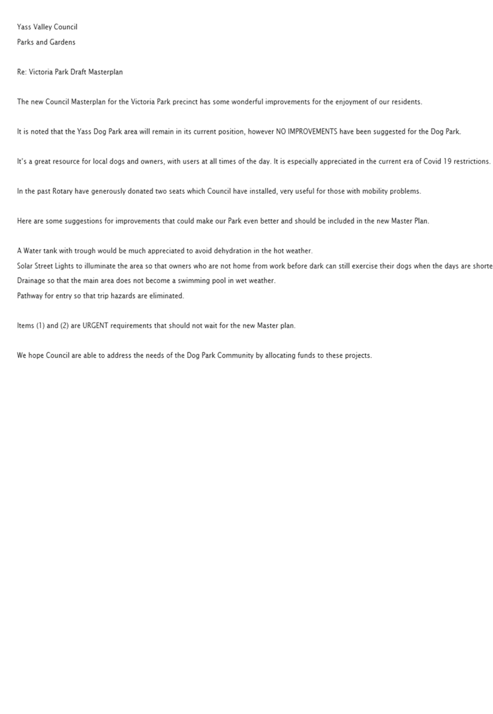
2.1 Dog Park Improvements
A few submissions suggested improvements to the dog park, including provision of water, formalising the entry gate surface, solar lighting for afterhours use, improved drainage and shade structures. These submissions have all been incorporated into the masterplan, recognising that long term drainage improvements will need to be designed and undertaken in conjunction with the pool development.
There was a suggestion to add an additional entry gate at the southern end of the Dog Park, however this is not supported as it increases the risk of dogs escaping especially if the gate is left open.
One submission raised the lack of new toilet amenities in proximity to the skate and dog park. While it is acknowledged that would be more convenient for users of those facilities, the existing toilets adjacent to the oval are already open 24 hours. The increased cost of cleaning and maintenance (especially due to vandalism) of another facility nearby is not financially viable.
2.2 Skate Park Improvements
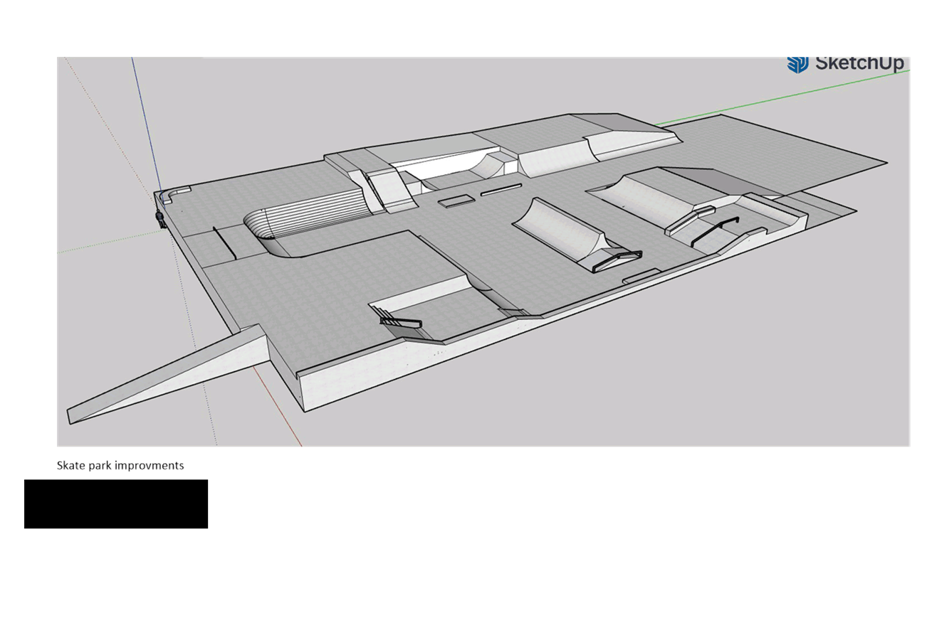
One of the submissions queried what improvements are proposed for the skatepark/teen play area. The draft proposed two new basketball courts, however potential improvements to the skate park were further refined through the consultation process.
A meeting was held with a representative on behalf of skate park users, which outlined some limitations of the current skate park and some suggested solutions. At present the design at Victoria Park does not cater for beginners or younger users, which can also lead to some conflicts and safety issues where more experienced or skilled users may collide or need to avoid those less experienced. A solution was suggested where an addition could be added to the southern edge of the existing skate park with handrails and lower slopes/grades. A similar project has been undertaken recently at Tumut.
A concept plan was submitted, and it was agreed that the solution and proposed location could be incorporated into the masterplan.
2.3 JA Allen Oval and Proposed Lookout
The Yass District Cricket Association agree with the proposed realignment of JA Allen Oval synthetic wicket, and support the orientation being within the recommended 10-15 degrees east of north to minimise impact of the sun on players. It also noted that any upgrade should include the current outfield to improve the hard and uneven surface.
The risk was raised of vehicular traffic using the Grampian Street entrance from cricket balls, footballs or even participants finding their way down the slope and into the path of oncoming vehicles which needs to be managed. It is proposed that ball stop fencing be installed at the bottom of this slope to reduce this conflict.
The proposed lookout at the south-western corner of JA Allen Oval was questioned. The rationale behind this is that it is a higher vantage point providing views over Yass and as the lack of shelter in the immediate area was also raised, a roofed structure can be provided over it as well.
The lack of access to drinking water nearby was raised, and the provision of a drinking fountain near the proposed shelter would benefit both users and spectators.
The issue of removal of the chain wire fencing between JA Oval and the main oval was raised as it prevents organisations from limiting entry should they wish to hold paid admission events e.g. football finals, concerts. The dual car entry points (Grampian Street and Laidlaw Street) may also present difficulties. Access and connectivity within Victoria Park is an objective of the masterplan, and these events are rare. As an alternative, organisations could ensure that volunteers are stationed at locations where people are most likely to enter.
2.4 Oval Improvements
A number of submissions sought clarification as to whether the six lane athletics track would be retained, and the masterplan has been revised to make it clear that it will be.
One of the submissions suggested conversion of the caravan park amenities building for additional change facilities or storage, particularly to cater for both male and female change facilities, and junior teams using JA Oval. This arrangement could present potential user conflicts (e.g. on weekends) as well as creating security issues. The need for additional change facilities had already been identified by Council, and an additional building is proposed to be located to the north of the current amenities building in the vicinity of the existing shipping container for this purpose, which is shown on the masterplan.
Concerns were raised regarding the proposed orientation of cricket practice nets include increased risk of damage to cars in proposed new carpark to the east, length of bowler run up (possibly too short), continued problem of shade and leaf drop from trees to the west. The suggestion of rotating nets slightly to the west to direct balls toward oval and away from cars to resolve this issue has been incorporated into the masterplan along with an additional electrical connection (for automatic bowling machine) and a drinking water tap.
Concerns that the 10m clearance proposed between the two rugby fields is limited for cricket set up (including line marking) and a risk this could be further reduced if additional space is required around the amenities building. It is noted that this separation should not be further reduced.
There was also a request for a clubhouse for viewing and functions, on top of the ground floor of the existing amenities building. This suggestion has not been incorporated, in part due to most sporting groups having existing sponsorship arrangements in place with hotels or clubs for social events. Locating a clubhouse on the first floor would also require reinforcement of the existing building and disability access to be provided which would likely make any proposal not financially viable.
Drainage around the centre wicket area of the oval has been raised, including the ability to take water away from the playing surface quickly when removing the cricket pitch covers. Detailed drainage design can be incorporated into any construction design of improvements to the oval.
2.5 Traffic and Parking
Submissions raised the formalisation of parking, vehicle and pedestrian access around the site and that it will restrict where vehicles can park. Users will be able to park near the cricket practice nets, pool, skatepark, dogpark, basketball and tennis courts. The longest distance from the nearest carpark will be to the amenities/canteen (approximately 70m). This distance is considered reasonable provided an accessible path of travel is provided. Furthermore, the two car spaces (in addition to the two disabled parking spaces) opposite Triggs Gates could be used as a short term parking/drop off area for canteen or equipment deliveries. The ovals will retain emergency vehicle access for any injuries that occur on field.
The sizing of the proposed south carpark was mentioned, with a suggestion of an additional centre row of parking or expansion further towards the tennis courts This suggestion was not supported as expansion towards the tennis club would mean removing the proposed playground, and an additional centre row would affect the pool and/or oval redevelopments.
There was concern that the slip lane off Laidlaw Street could create a traffic problem if there is any sort of queuing that flows back onto Laidlaw Street, however the slip lane is intended for buses only, with passenger vehicles directly accessing either the southern or eastern carparks.
The issue of spectator viewing from cars was raised with the proposed oval configuration, however car parking is proposed to the east of the main oval, new sheltered seating and carparking to the south and the amenities building to the west will offer a range of spectator options, in a safer and more formalised arrangement.
In response to feedback from Council’s Road Safety Officer, the proposed flow of traffic from Grampian Street through the upgraded carpark at Victoria Park east through to the school and the school carpark has been amended to provide two-way traffic flow from the car park utilised by the High School.
2.7 Riverbank Riparian Area
Concern was raised that any rapid environmental restoration of the riverbank area may threaten species which utilise the habitat particularly understorey vegetation. This concern is noted, and any restoration will need to be planned and staged with the assistance/input of Council and Yass Landcare. Preparation of a riverbank flora and fauna management plan has been included as an action within the implementation plan.
2.8 Tennis Courts
Storage needs for the tennis clubs were raised and as such a small extension to the existing tennis building is shown to address this.
A submission raised the need to have careful consideration of tree plantings in proximity to the tennis courts. This was also raised at the workshop with user groups and while no new trees are proposed, managing existing trees and potential damage from them is acknowledged as an ongoing issue, with a notation that tree root barriers could be installed to reduce damage to the courts.
2.9 Opportunity to rename Victoria Park
The emphasis of Connection to Country in the masterplan was noted in one submission, and it was suggested that Council consider renaming Victoria Park with a Ngunnawal name. This suggestion recognises the Traditional Owners of the land within the Yass Valley and acknowledges the generic use of the term ‘Victoria’, applied to many parks, streets, suburbs and buildings built during the reign of Queen Victoria and that it is not unique to Yass. Rather than incorporating this in the masterplan, this suggestion should be forwarded to the new Aboriginal Advisory Committee and Council.
3. Conclusion
The draft masterplan has been amended to incorporate the feedback from user groups and the wider community at Attachment B. The resultant plan will form the basis of the Plan of Management required under the Local Government Act 1993 and Crown Land Management Act 2016. The projects and works identified within the plan will also support grant applications under the Crown Reserves Improvement Fund.
Key Pillar 4. Our Infrastructure
CSP Strategy IN4 - Maintain and update existing community facilities, and support the development of new community infrastructure as needed
Delivery Program Action IN4.1 - Develop and maintain new and existing recreational and community assets to address our communities needs in a sustainable manner
Operational Plan Activity IN4.1.4 - Complete the Victoria Park Masterplan
ATTACHMENTS: a. Final Masterplan (Under Separate Cover) ⇨
b. Submissions ⇩
6.2 Crown Lands Miscellaneous Reserves Draft Plan of Management
The purpose of this report is to recommend public exhibition of the draft Plan of Management (POM) for the Yass Valley Miscellaneous Crown Reserves.
Nil
· Crown Lands Management Act 2016
· Local Government Act 1993
The Crown Land Management Act 2016 came into force on 1 July 2018. As the appointed land manager, Council is required to prepare a Plan of Management (POM) for these reserves as if they were community land under the Local Government Act 1993. A POM outlines how the land can be used, developed and managed, how leases and licences or other interests are granted on community land and determines the scale and intensity of current and future use and development on the land.
A draft POM has been prepared for miscellaneous reserves that are Crown Reserves under the control and management of the Council and are identified below as Figures 1, 2 and 3.
On 28 February 2020 the Minister for Water, Property & Housing approved the categorisations of General Community Use, Park and Natural Area all of which are consistent with the Crown Land purpose of ‘Public Recreation’ for each of these Reserves.
The draft POM provides direction for the asset management of these reserves. The plan outlines the way the land within the reserves can be used and provides the framework for Council to follow in relation to the leasing, licencing and permit processes for the land. It should be noted that Council is still awaiting confirmation as to whether there are any existing claims on any of these reserves under the Aboriginal Land Rights Act 1983. The POM can be referred to the owner of the land while awaiting this advice.
The draft POM at Attachment A is considered suitable for public exhibition to seek feedback from the community on the proposed management of these reserves.
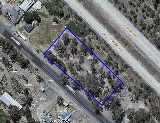
Figure 1 Bookham Reserve: 84528 (Public Recreation) being Lot 118 DP 878500
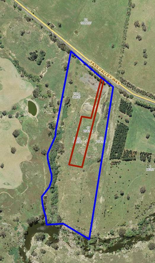
Figure 2 Yass Reserve: 95524 (Public Recreation) being Lot 22 DP 754149 and Lot 7004 DP 94637
Note: the management of this reserve has been devolved to Council for the purpose of a Rubbish Depot on Reserve 82204 (outlined in red above). The reference to it has only been included as it is contained by Reserve 95524, and the rubbish deport use extended beyond the area originally set aside for that purpose.
Figure 3: Binalong Reserve: 97980 (Public Recreation) being Lot 7305 DP 1147889
Key Pillar 1. Our Environment
CSP Strategy EN4 - Maintain a balance between growth, development and environmental protection through sensible planning
Delivery Program Action EN4.1 - Ensure Council's statutory planning instruments are up to date and reflective of the community needs
Operational Plan Activity EN4.1.1 – Complete the comprehensive development control plan
ATTACHMENTS: a. Draft Plan Of Management (Under Separate Cover) ⇨
Ordinary Council Meeting 1 December 2021
6.3 Climate Change and Natural Disaster Risk Assessment
SUMMARY
A Climate Change and Natural Disaster Risk Assessment allows Council to consider and prepare for and respond to the risks presented by climate change in ongoing operations and core activities. It also provides opportunities for Council to obtain funding to take identified priority actions.
|
That the completion of the Climate Change and Natural Disaster Risk Assessment be noted |
Financial IMPLICATIONS
Nil.
POlicy & Legislation
· Environmental Sustainability Policy
REPORT
1. Introduction
A Climate Change and Natural Disaster Risk Assessment has been completed to allow Council to prepare for a range of scenarios including a change in rainfall patterns, higher average temperatures, longer heatwaves, and more frequent and intense storms, droughts and bushfires. These scenarios can directly impact on the functionality of Council.
The Climate Change and Natural Disaster Risk Assessment allows Council to prioritise actions to increase the resilience of its operations, the community and the local. The Risk Assessment will also form the basis for Council to proceed with a Climate Change Adaptation Strategy, including actions to address the key risks identified.
2. Climate Change and Natural Disaster Risk Assessment
The Assessment identifies climate change elements which may cause a risk to Council operations and lists the impacts that are most likely to have a potential medium or high risk level. It will assist Council in prioritising actions to increase the resilience of its operations, the community and the local environment. Council can now use this document to consider the risks presented by climate change and natural disasters ultimately guiding decision making.
Key Pillar 5. Our Civic Leadership
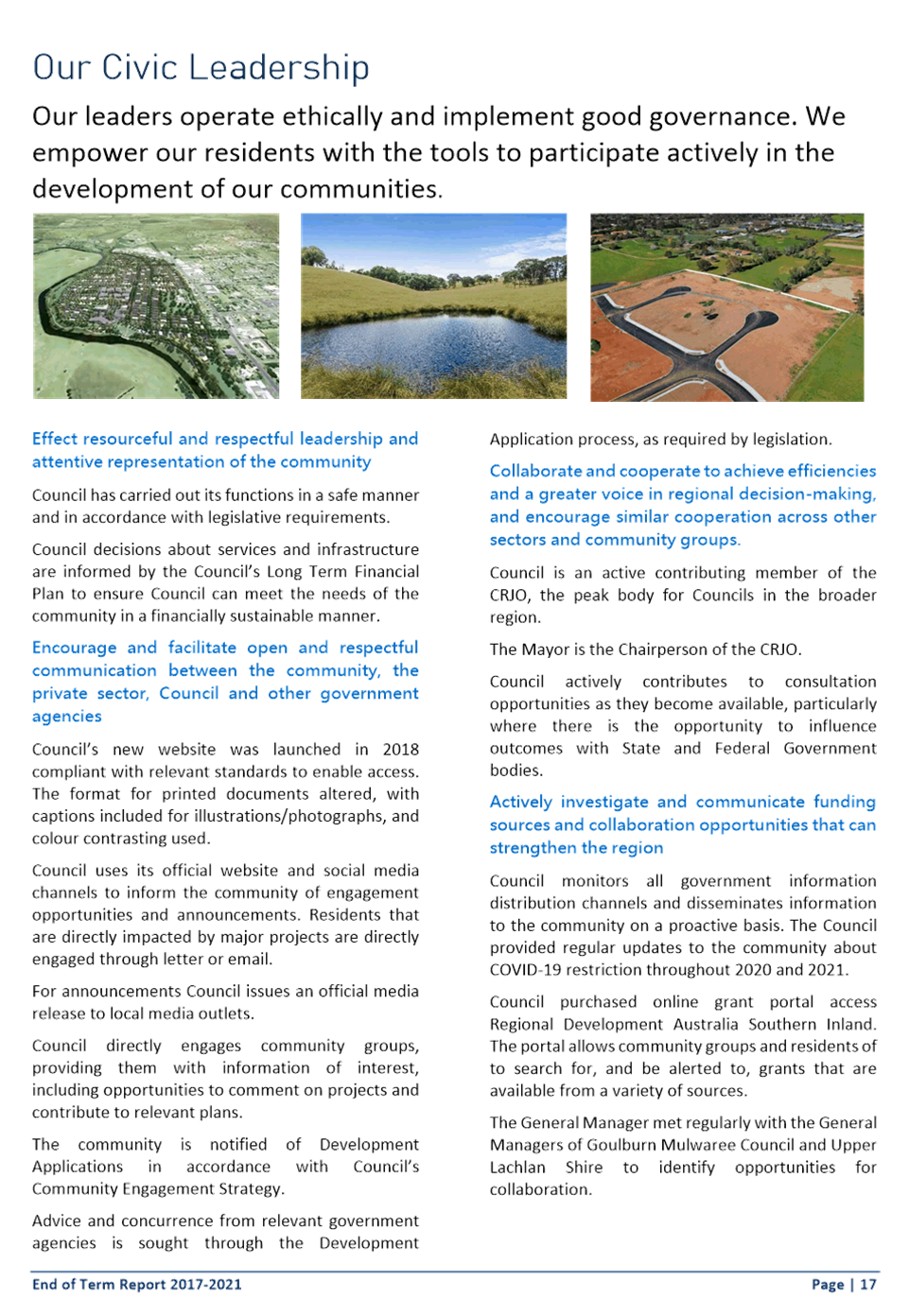
CSP Strategy CL1 - Effect resourceful and respectful leadership and attentive representation of the community
Delivery Program Action CL1.3 - Meet its objectives through improving the effectiveness of risk management, controls and governance processes
Operational Plan Activity CL1.3.3 - Finalise the Climate and Natural Risk Hazard Risk Assessment
ATTACHMENTS: a. Climate Change and Natural Disaster Risk Assessment (Under Separate Cover) ⇨
Ordinary Council Meeting 1 December 2021
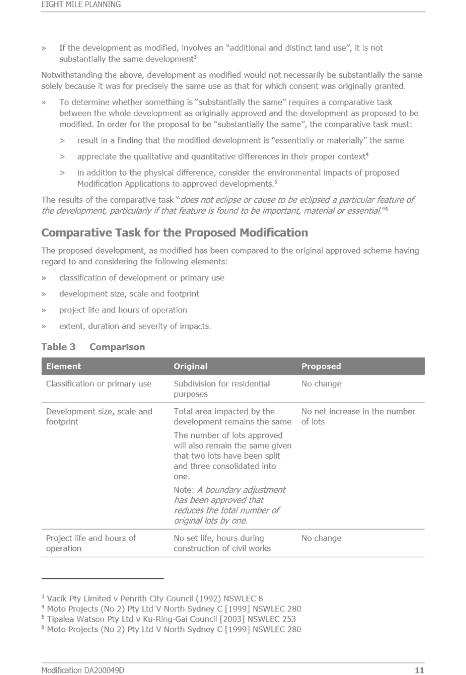
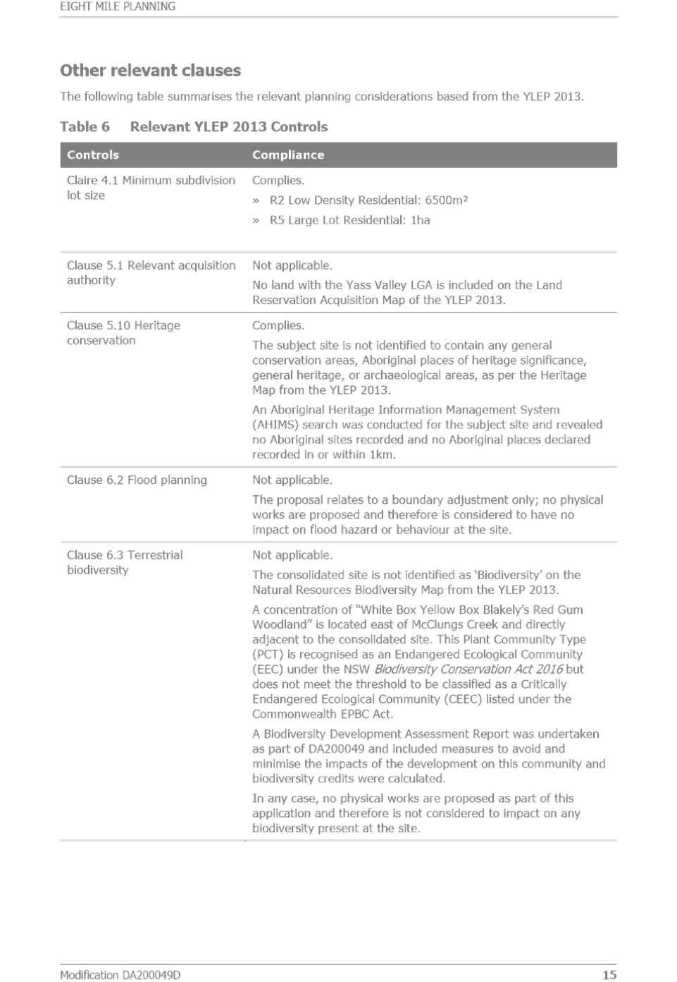
6.4 Development Consent No 2000049 - 101 Lot Subdivision, Isabel Drive, Murrumabteman
Summary
To present the assessment of a request to modify Development Consent DA200049 for 101 lot subdivision at Isabel Drive, Murrumbateman. The request attracted two new submissions and relevant concerns can be addressed by conditions. Approval is recommended.
|
That: 1. Development Consent DA200049D be modified for the 101 lot subdivision at Lot 1 DP 1257138, Isabel Drive, Murrumbateman 2. That the roundabout construction be bonded to enable the release of Subdivision Certificate. The roundabout is to be constructed within 12 months of the date of Subdivision Certificate, unless otherwise agreed to 3. The area including the shared path between the new road and Colonial Place is to be a separate open space lot and included in the Voluntary Planning Agreement for open space within the subdivision 4. The draft Voluntary Planning Agreement be amended to include this separate open space lot and be placed on public exhibition in accordance with the Environmental Planning & Assessment Act 1979 and adopted if not significant submissions are received 5. Upon dedication to Council the open space lot be classified as Community Land under the Local Government Act 1993 |
FINANCIAL IMPLICATIONS
Resources for development assessment are provided for in the current Operational Plan.
POLICY & LEGISLATION
· Environmental Planning & Assessment Act 1979
· Environmental Planning & Assessment Regulation 2000
· Local Government Act 1993
· Roads Act 1993
· Yass Valley Local Environmental Plan 2013
· Road Standards Policy
· Application Assessment & Decision Making Policy
· Development Consent DA200049D
REPORT
1. Application Details
|
Date Received |
- |
7 September 2021 |
|
Land |
- |
Lot 1 DP 1257138, Isabel Drive, Murrumbateman |
|
Area |
- |
99.55ha |
|
Zoning |
- |
R2 Low Density Residential & R5 Large Lot Residential |
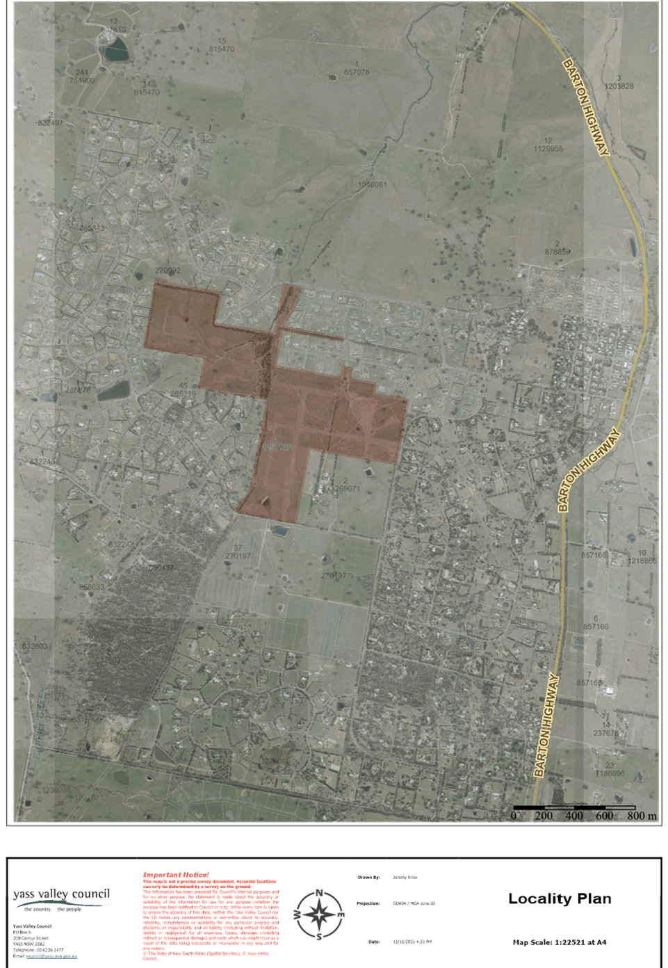
2. Site Description and Locality
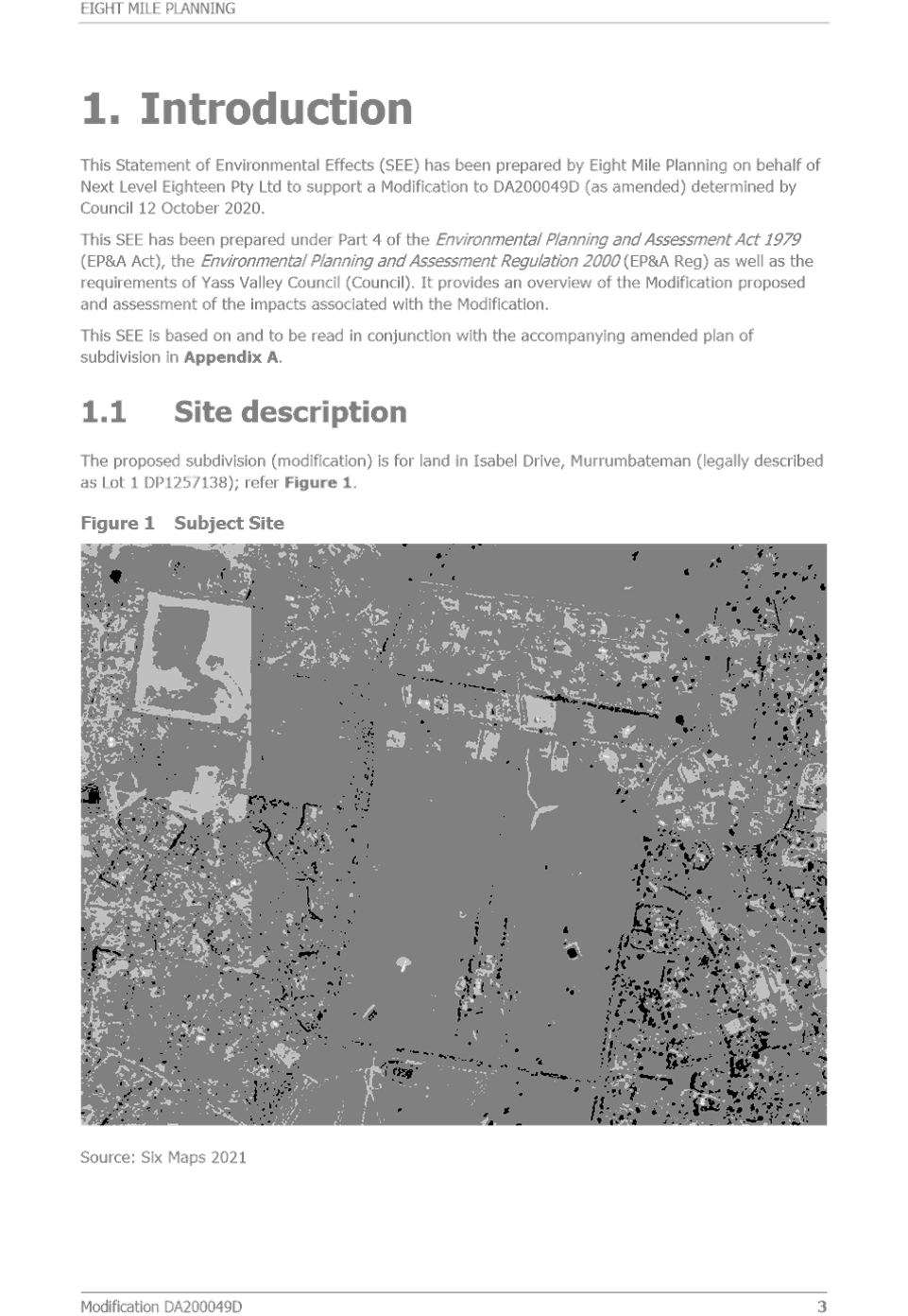
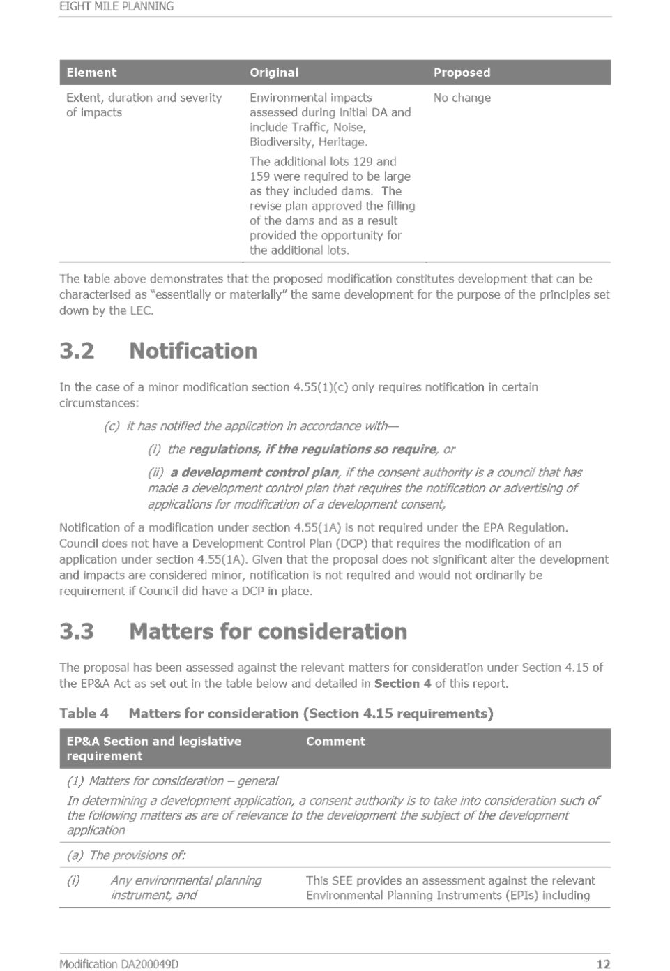
The development site is approximately 100ha in size and located west-southwest of the Murrumbateman Village. It is an irregular shape with frontage to Isabel Drive, McIntosh Circuit, Colonial Place and Merryville Drive. The site is bordered by Shaw Winery, Merryville Estate and Carrington Park Estate and was formerly part of the Shaw Vineyard Estate.
The site is generally undulating with the highest areas being towards the centre. McClungs Creek bisects the site and there are several other drainage lines and dams. Part of the site is identified as having significant native vegetation.
Under the Yass Valley LEP 2013 the eastern portion is zoned R2 Low Density Residential with minimum lot size of 6,500m2 and the western portion is zoned R5 Large Lot Residential with a minimum lot size of 1ha.
Subdivision works are currently occurring with the construction of roads underway.
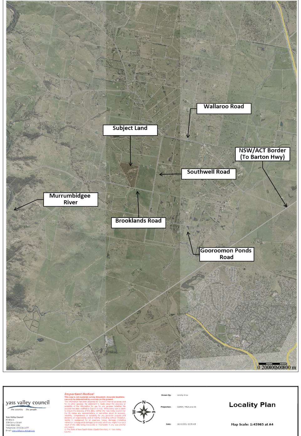
A Locality Plan is included in Attachment A.
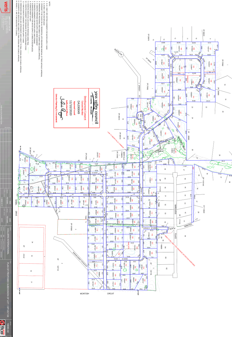
3. Proposal
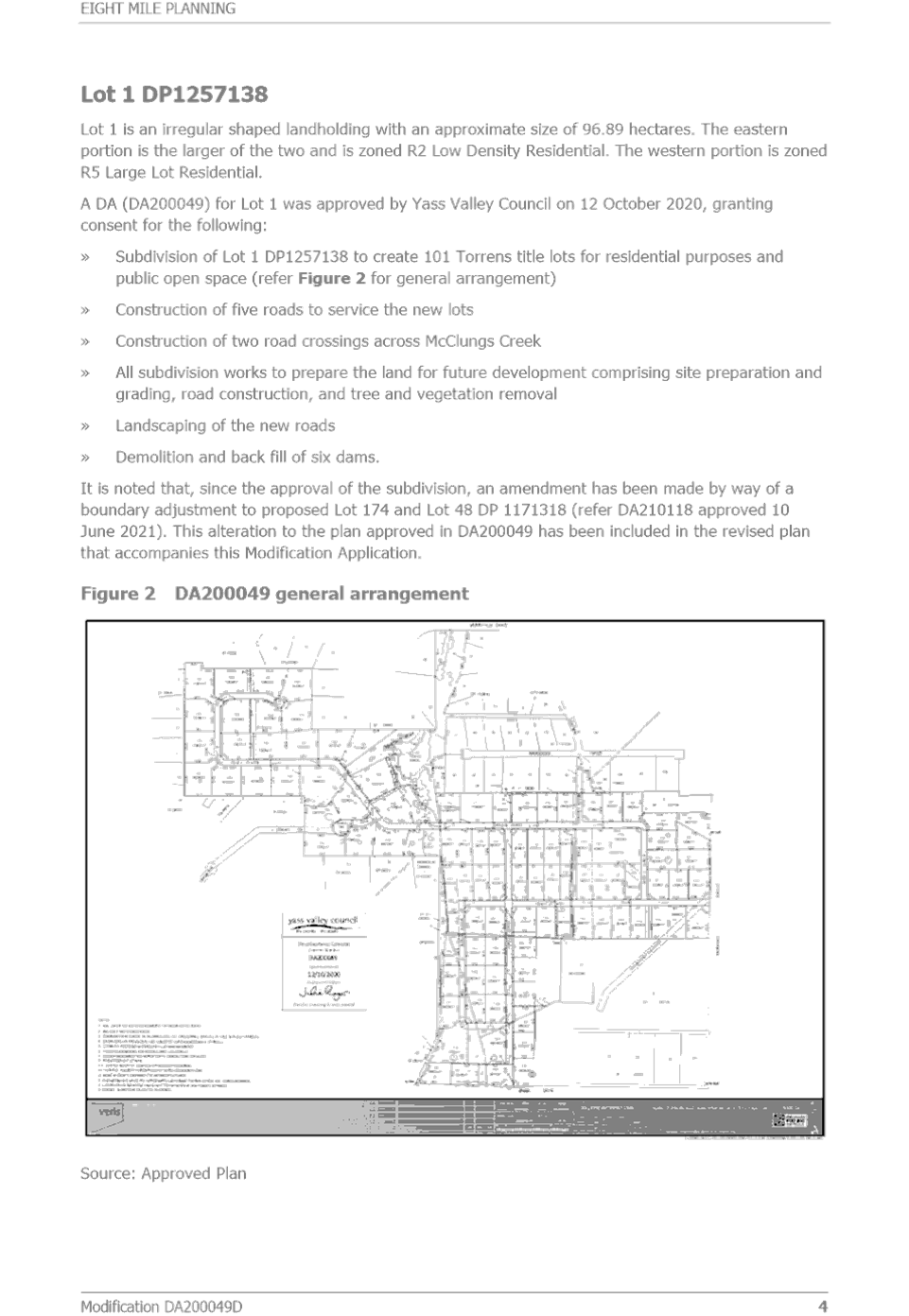
In September 2020 Development Consent was granted for the 101 lot subdivision (refer Attachment B). The subdivision included the creation of open space along the creek, with Council in December 2020 resolving to accept the open space through a Voluntary Planning Agreement (VPA).
The submitted modification application involves the following changes:
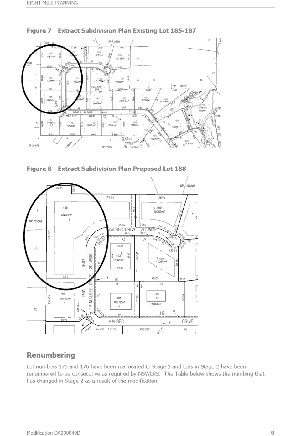
· Consolidation of approved Lots 186, 187 and 188 into a single lot
· Splitting each of Lots 129 and 159 into two
· Changing the proposed extension of Colonial Place from a local road to shared path only
· Deferring construction of the roundabout to allow consideration of an alternative location and allow release of the Subdivision Certificate
Details of the proposed modification are included in Attachment C.
4. Public Exhibition
Public exhibition included notification to persons who had previously made a submission on this Development Application.
There were two new submissions received in relation to the modification (refer Attachment D). However, the original Development Application attracted 65 submissions and there are issues that were raised in those submissions which remain relevant to changes now proposed in the modification application. The issues raised in new and previous submissions relevant to the modification include:
· Access and road network – McIntosh Circuit roundabout
· Colonial Place connection
· Stormwater drainage – Colonial Place
5. Assessment
An assessment of the proposal has been completed in accordance with the Planning Legislation. The proposal generally complies with the relevant planning controls, policies and guidelines.
The following planning issues have been identified including the response to the issues raised in submissions.
5.1 Access and Road Network – McIntosh Circuit Roundabout
The existing consent requires the construction of a roundabout at the intersection of McIntosh Circuit and the new road (north of Isabel Drive). The Applicant has requested that the roundabout construction be bonded to allow the reconsideration of the location i.e. whether construction at intersection of McIntosh Circuit and Isabel Drive may be more appropriate.
Another Development Application has recently been lodged by the Applicant for a 27 lot subdivision on corner of McIntosh Circuit and Isabel Drive. At time of writing this report, the assessment and public exhibition of this application had not commenced.
The intersection with McIntosh Circuit was a significant issue raised in submissions on the original Development Application and the construction of the roundabout was a Consent condition. A submission received for the modification also stated that traffic on McIntosh Circuit has become very bad due to the construction works and they would strongly object to anything that delayed planned traffic calming measures. Another submission objected to construction being deferred as they were concerned it would never happen.
Any bond lodged by the Applicant for the work would be for 150% of the value of the roundabout construction. This would allow the Subdivision Certificate to be issued (i.e. creating the new lots) and the roundabout construction required within 12 months, unless otherwise agreed to.
The use of a bond is considered appropriate in the context of the approved and proposed subdivisions to ensure a suitable location for the roundabout.
5.2 Colonial Place Connection
The approved subdivision has a road connection into Colonial Place and provision for this connection had been made in the Carrington Park subdivision. The Applicant has requested that the road connection into Colonial Place be deleted in favour of a shared path. The civil works has identified that the soil conditions at this location will potentially present an issue for ongoing maintenance of the road.
The road connection into Colonial Place is not essential as the connections to Isabel Drive and McIntosh Circuit are likely to be the primary routes. Based on the submissions received on the original Development Application and a submission received for the modification, it is considered that the shared path would be preferred by residents in Carrington Park Estate as this removes any through traffic.
It is now also proposed to include a stormwater detention basin within the shared path which was originally located in the adjoining lot. The stormwater detention basin is designed for temporary detention rather than as a pond or dam that holds water on a semi-permanent basis. It is shallow and designed so that it could be slashed minimising the maintenance liability. The nature of the detention basin does not require fencing or lifesaving safety equipment.
It is recommended that the proposed change be supported subject to:
· The area be created as a separate lot rather than road reserve and is to be dedicated to Council as open space. Upon dedication the open space lot is to be classified as Community Land under the Local Government Act 1993
· The area is added into the open space proposed to be dedicated to Council through the Voluntary Planning Agreement. This requires maintenance responsibilities for the Developer for the first five years
· Revised engineering details are submitted for approval which detail how the design of the stormwater detention pond prevents the risk of scouring out the shared path when it overflows
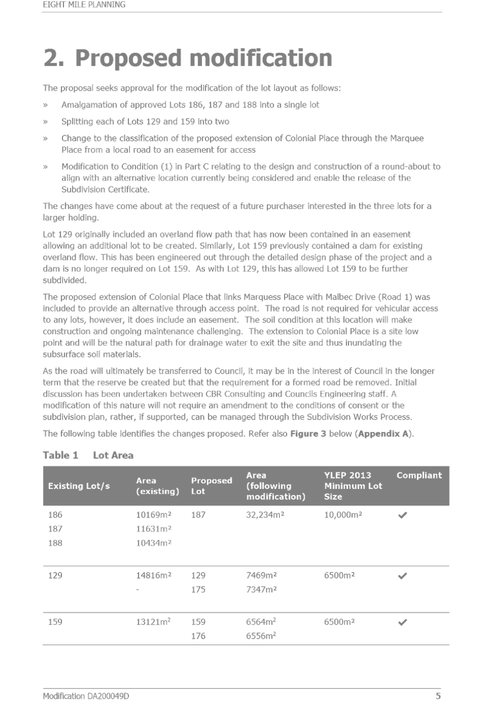
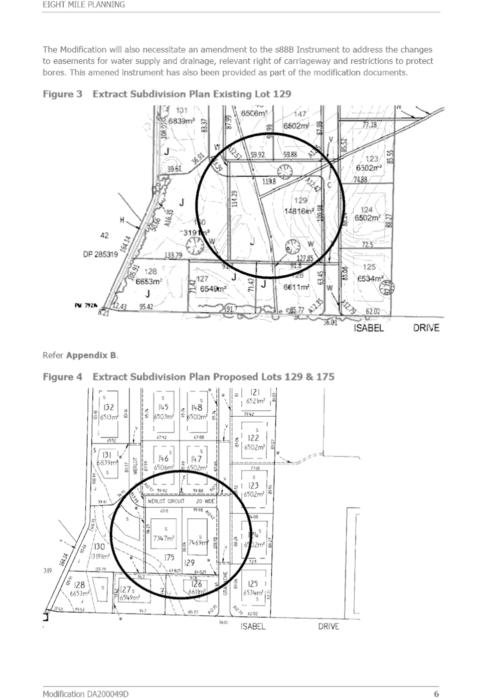
5.3 Change to Lot Layout
The following changes to the lot layout are proposed:
· Consolidation of approved Lots 186, 187 and 188 into a single lot
· Splitting each of Lots 129 and 159 into two
There are no issues associated with the amalgamation of approved Lots 186, 187 and 188 into a single lot.
It is important to note that the size of Lot 129 was increased from the first version of the subdivision layout submitted with the Development Application in 2020. This was in response to concerns raised in submissions relating to the management of overland stormwater across the subdivision. In response the Applicant had proposed to amalgamate these lots to better address stormwater outcomes and drainage back to McClungs Creek.
The Applicant has indicated that the stormwater design approved in the Subdivision Works Certificate reflects the proposed change with the splitting of these lots. However, this is not entirely the case and revised stormwater design details would need to be provided.
The proposed lot layout changes do not change the number of lots nor result in any adverse planning outcomes. This can be supported, subject to amended conditions requiring revised stormwater design details to ensure stormwater outcomes are achieved.
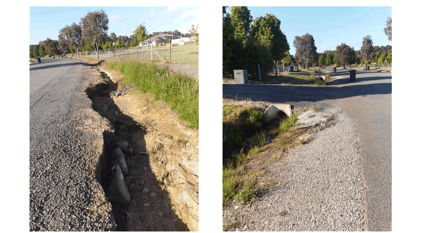
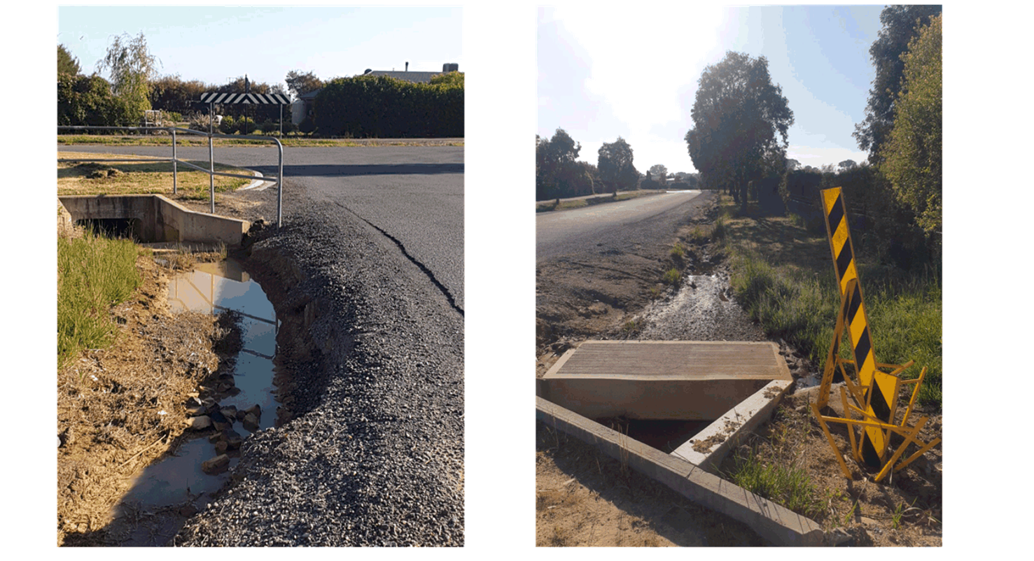
5.4 Stormwater Damage – Colonial Place
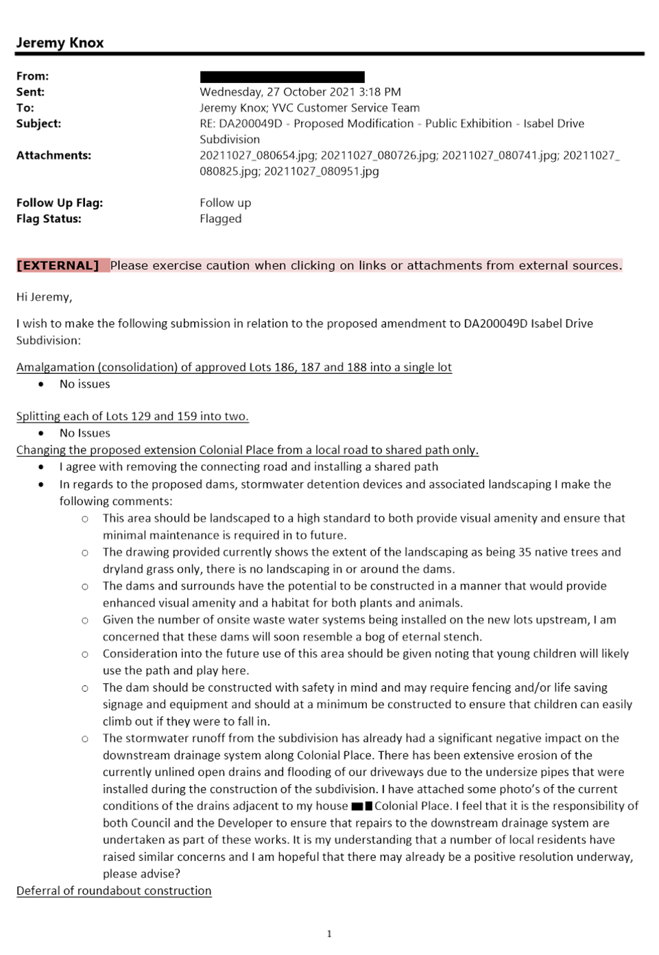
Concern has been raised in a submission that stormwater runoff from the subdivision construction works is causing damage to the drainage swales and the edge of road pavement in Colonial Place. This issue has been previously raised and investigations suggested that it was existing stormwater arrangements from the top of Colonial Place that were resulting in the damage to the drainage swales, rather than the subdivision. However, this will be reviewed again by Council.
6. Conclusion
From the assessment of the proposal and consideration of issues raised in submissions, it is recommended that the Development Consent be modified. Draft conditions are included in Attachment E.
Strategic Direction
Theme 1. – Our Environment
Long Term Goal EN4 – Maintain a balance between growth, development and environmental protection through sensible planning
Strategy EN4.2 – Ensure development application assessment is thorough and efficient
Strategic Action EN4.2.1 – Implement the development process and implement changes aligning with the NSW Government’s best practice guidelines.
ATTACHMENTS: a. Locality Plan ⇩
b. Approved Plan of Subdivision ⇩
c. Proposed Modification Supporting Details ⇩
d. Submissions ⇩
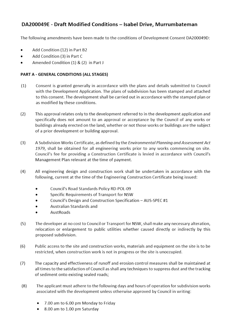
e. Draft Modified Conditions ⇩
6.4 Development Consent No 2000049 - 101 Lot Subdivision, Isabel Drive, Murrumabteman
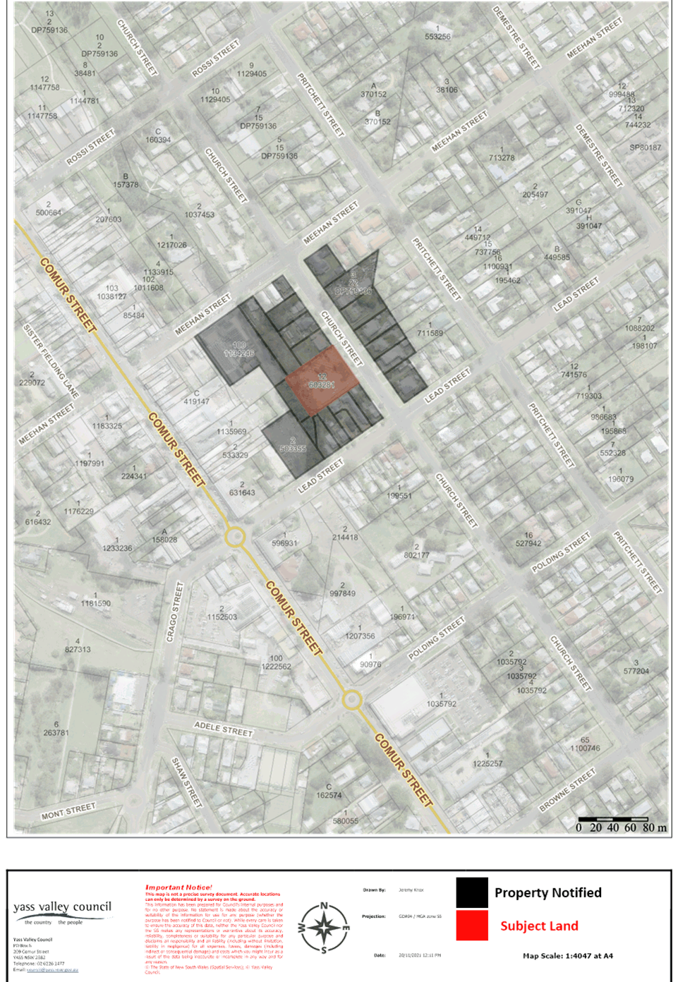
Attachment a Locality Plan
6.4 Development Consent No 2000049 - 101 Lot Subdivision, Isabel Drive, Murrumabteman
Attachment b Approved Plan of Subdivision
6.4 Development Consent No 2000049 - 101 Lot Subdivision, Isabel Drive, Murrumabteman
Attachment c Proposed Modification Supporting Details
Attachment d Submissions

Attachment e Draft Modified Conditions

6.5 Development Consent No DA175279 - Preschool, 37 Church Street, Yass
Summary
To present the assessment of a request to modify Development Consent No DA175279 for a preschool at 37 Church Street, Yass. The request attracted five submissions and it involves a proposed variation to Council’s Offstreet Carparking Policy. Relevant concerns can be addressed by conditions. Approval is recommended.
|
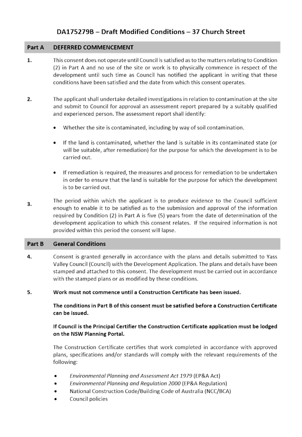
That Development Consent No DA175279 be modified for a preschool at 37 Church Street, Yass. The modified Development Consent is to remain under a deferred commencement subject to contamination investigations being undertaken |
FINANCIAL IMPLICATIONS
Resources for development assessment are provided for in the current Operational Plan.
POLICY & LEGISLATION
· Environmental Planning & Assessment Act 1979
· Environmental Planning & Assessment Regulation 2000
· State Environmental Planning Policy (Education Establishments and Child Care Facilities) 2017
· State Environmental Planning Policy No. 55 – Remediation of Land
· Yass Valley Local Environmental Plan 2013
· NSW Childcare Planning Guideline 2017
· Guide to Traffic Generating Development
· Offstreet Carparking Policy
· Application Assessment and Decision Making Policy
· Yass Floodplain Risk Management Study and Plan 2021
· Community Engagement Strategy
· Local Government Act 1993
· Roads Act 1993
REPORT
1. Application Details
|
Date Received |
- |
30 August 2021 |
|
Land |
- |
Lot 12 DP 603281, 37 Church Street, Yass |
|
Area |
- |
3,400m2 |
|
Zoning |
- |
R1 General Residential |
2. Site Description and Locality
The site is located in Church Street, Yass, between Meehan and Lead Streets. It is zoned R1 General Residential and it is an area characterised by mainly residential development, however is at the zone interface with the Soldier’s Club carpark adjoining at the rear.
The site has fall from the Church Street and backs onto Chinaman’s Creek at the rear. Until recently the site had a derelict building that had historically been used as a cordial factory, but that has since been demolished. There are some established trees on the site, mainly towards the rear. Some trees have been removed around time of the demolition.
A Locality Plan is included in Attachment A.
3. Proposal
In 2018 Development Consent was granted for the conversion of the derelict cordial factory building to a preschool with a maximum of 45 children.
The modification application now involves the construction of new buildings (as the former cordial factory building has since been demolished) and increasing the maximum number of children to 90.
Details of the proposal are included in Attachment B.
4. Public Exhibition
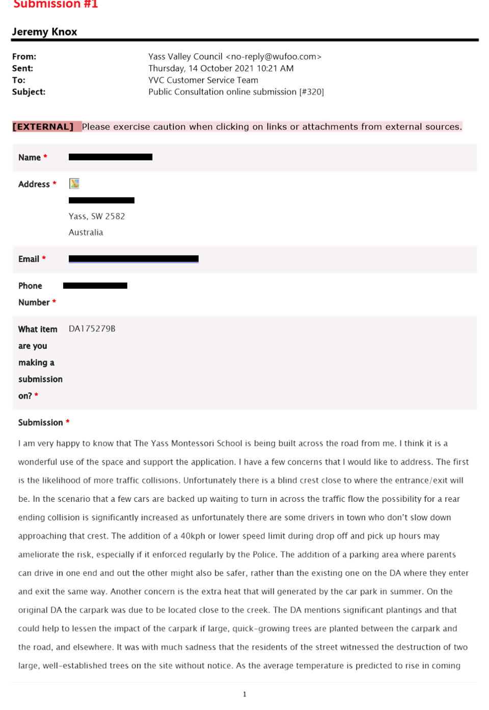
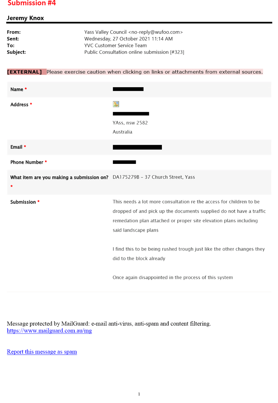
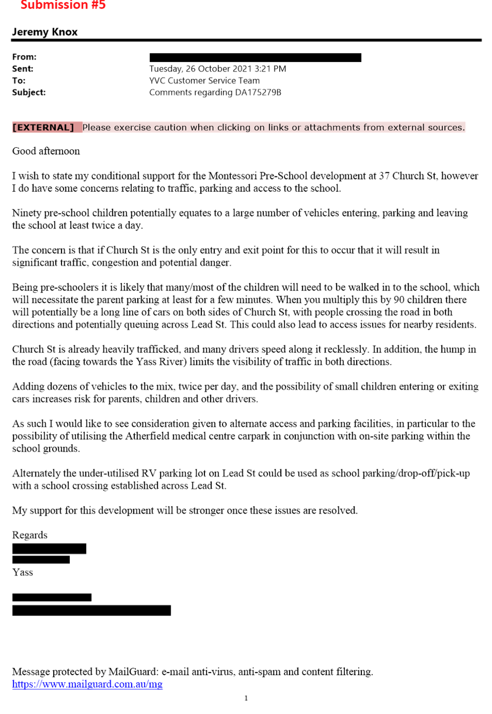
Public exhibition included notice to 19 adjoining and nearby landowners and five submissions have been received (refer Attachment C).
Three of the submissions support the use of the site as a preschool but raise general issues of concern or objection. The other two submissions raise issues of concerns or is an objection.
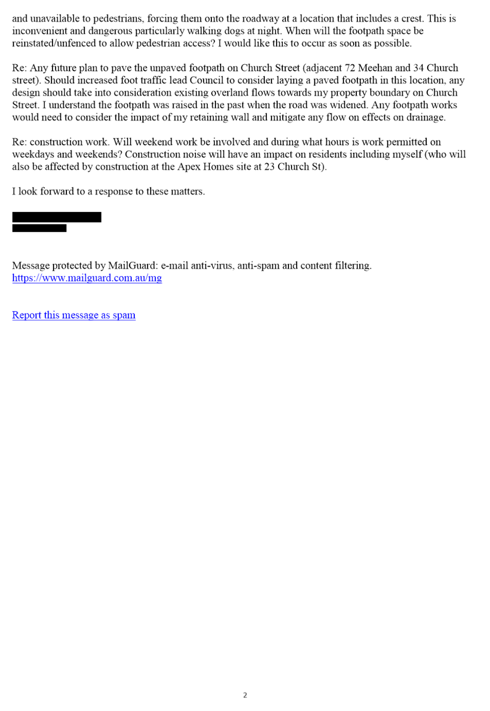
The key issues relate to:
· Validity of application – i.e. modification vs. new DA
· Car parking and traffic
· Footpaths
· Tree removal
· Construction impacts
5. Assessment
An assessment of the proposal has been completed in accordance with the Planning Legislation. The proposal generally complies with the relevant planning controls, policies and guidelines.
The following planning issues have been identified including the response to the issues raised in submissions.
5.1 Validity of Application - Modification vs. New DA
Section 4.55(1A) Environmental Planning & Assessment Act 1979 allows for modifications to Development Consents where it ‘substantially the same development’.
One of the submissions suggest that the application should not be considered as a modification, rather a new Development Application should be lodged given the extent of the changes and the doubling of the number of students – i.e. not minor environmental impact nor substantially the same development.
The modification application has been lodged pursuant to s4.55(1A) of the Act which is for modifications involving minimal environmental impacts. A review has indicated that the modification application is more appropriately considered pursuant to s4.55(2) of the Act which allows for other modifications. This is due to the proposed modification doubling the number of children and proposes to construct new buildings on site rather than repurposing the existing building. However, it is considered the proposed development remains substantially the same in that it is for the purposes of a preschool.
5.2 Car Parking and Traffic
Concern has been raised in the submissions in relation to car parking and traffic, including:
· The blind crest in Church Street and the potential for more collisions, especially if cars are backed up attempting to turn right across Church Street into the preschool
· Speed limit – suggestion to drop to 40km/hr
· Suggestions that single driveway may be a conflict point and a drive through car park which has a separate entry and exit may be safer
· Movement of staff not detailed in Statement of Environmental Effects
· Number of car parks not adequate
· Unreasonable for the road verge to be used for any drop off or short term parking, especially with the camber on Church Street
· Carpark design appears to be too tight to enable manoeuvring
· Suggestion for ‘no right turn’ when exiting the driveway into Church Street
· Safe pedestrian access into the building is not provided
· Centreline on Church Street should be implemented
· Does not appear to be suitable fire and ambulance access
· Suggestion that Church Street should have a centreline marked
The NSW Child Care Planning Guideline 2017 recommends that Applicants prepare a Traffic and Parking Study, however this has not been provided with the application.
Car Parking Numbers
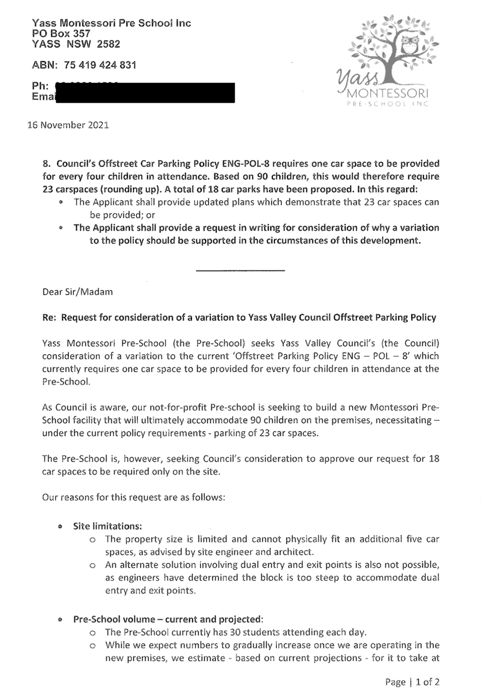
Council’s Offstreet Carparking Policy requires one car space to be provided for every four children. This policy is based on the Transport for NSW’s Guide to Traffic Generating Developments and is mostly consistent with the NSW Child Care Planning Guideline (except if the site is in an area which is well connected to public transport or there is sufficient on street or other parking appropriately provided in area, the numbers can be reduced).
Based on 90 children there would need to be 23 on site car spaces provided. The Applicant proposes to provide 18 car spaces and has requested Council consider a variation to the policy (refer Attachment D) given the site constraints and costs of constructing the carpark.
The Applicant’s justification states that the 90 children capacity would not be reached for at least six years. However, in assessing the application, the car space number must be considered on the maximum number of children proposed. The Applicant could reduce their proposed maximum number of children to 72 and this would then comply with the policy. It is understood that this would be problematic with external grant funding for the preschool which is requiring 90 places to be provided.
The Applicant has requested consideration of use of the Atherfield public carpark for the five additional car spaces, noting intended beautification works along Chinamans Creek and the potential to construct a footbridge to access the site. The is generally not suitable in context of considering this application given there are no certain plans relating to the beautification works or whether foot bridge would be feasible.
The Applicant has also proposed to stagger the start time of classes to manage the number of cars arriving at any one time. This is considered a practical measure for managing car parking, however there is difficulty is in ensuring that this occurs in perpetuity.
It is likely that without sufficient car spaces being provided on site it will result in parking on the street. Whilst there is sufficient width in Church Street for on street parking, it is not currently line marked, and has a relatively high camber towards the edge of the street. Council has also previously supported a variation of five car spaces for a 100 place child care centre at 116 Rossi Street (Development Application DA145133).
If Council were to support the proposed variation it would be recommended that the deficit is made up by formalising on street parking on the preschool side of the street and applying the following conditions:
· That Church Street be line marked between Meehan and Lead Street
· That the on street parallel car spaces be line marked on the preschool side of Church Street
· Footpath to be constructed along the length of Church Street to the existing footpaths on Lead and Meehan Streets providing connectivity back to existing car parks and promoting active transport
· The internal car park is to be no right turn when coming out the driveway onto Church Street
Concerns have also been raised that the car park design may not have sufficient space to enable manoeuvring of vehicles. Draft conditions require engineering drawings to be submitted demonstrating that the car park has been designed in accordance with the relevant standards prior to the issue of a Construction Certificate.
Speed Limit
The submissions request that the speed limit be permanently reduced to 40km/h or a ‘school zone’ be introduced in this part of Church Street.
Council cannot reduce the speed limit through conditions of consent as speed limits are determined by Transport for NSW via the Traffic Committee and school zones are used for primary and secondary schools. A reduction in speed limit is not considered to be warranted noting the measures such as line marking and no right turn out of the site that will be required.
Church Street Footpath
The submissions note that there has been no mention of pedestrian traffic which is likely to increase in Church Street and that the verge at the site is currently blocked with the construction fence. One submission then also outlines concerns relating to changes in overland water flows if a footpath was to be constructed to the intersection of Church and Meehan Street.
The existing conditions of the Development Consent require a 1.5m wide footpath to be constructed immediately outside the subject land. It is proposed that this requirement be increased given the variation to onsite car parking, with the footpath being constructed for the length of Church Street between Meehan and Lead Streets.
The draft conditions require engineering drawings for the footpath to be submitted. This will need to detail how overland flow will work including impacts on adjoining properties.
Carpark Pedestrian Areas
Concern is raised in the submissions that there is not safe pedestrian access to the buildings from the car park. The NSW Child Care Planning Guideline promotes suitable design solutions in relation to internal car parks and pedestrian movement. Draft conditions can require the car park design drawings that are submitted prior to Construction Certificate to address the design principles from the Guideline, including:
· Separate pedestrian access from the car park to the facility
· Defined pedestrian crossings included within large car parking areas
· Separate pedestrian and vehicle entries from the street for parents, children and visitors
· Pedestrian paths that enable two prams to pass each other
· Delivery and loading areas located away from the main pedestrian access to the building and in clearly designated, separate facilities
· Child safe fence to separate car parking areas from the building entrance and play
Furthermore, conditions in any consent can require the internal car parks to be rear to kerb only with appropriate signs in place to further reduce risks.
5.3 Tree Removal and Landscaping
Concern has been raised that further tree removal may be required. A tree removal plan identified that five mature trees towards the rear boundary need to be removed. The trees proposed to be removed do not have high habitat value but are likely to be providing stability to the creek banks. The Applicant will need to provide a soil and erosion management plan prior to Construction Certificate which details how erosion will be managed around the tree removal and construction, and how the area will be suitability rehabilitated so that is stabilised.
The submissions also suggest that the removal of more trees and construction of building and hard stand areas such as the car park may increase temperatures in the immediate area i.e. the ‘heat island effect’. This is acknowledged and the Applicant has provided details of areas landscaping to be undertaken on the site.
The proposed landscaping is mainly behind the building line with the car park presenting to the street. The location of the car park near the front boundary has left limited opportunity for landscaping noting that Church Street is within the Heritage Conversation Area. The NSW Child Care Planning Guideline makes design recommendations that should be taken into consideration to incorporate car parking into the landscaping design of the site:
· Planting shade trees in large car parking areas to create a cool outdoor environment and reduce summer heat radiating into buildings
· Taking into account streetscape, local character and context when siting car parking areas within the front setback
· Using low level landscaping to soften and screen parking areas
An assessment shows that these design guidelines are not currently being achieved and the car park is not well incorporated into the landscaping design, noting that the design has been driven partly by the number of required car spaces and the fall of the site. It is recommended that a landscape plan be prepared by a suitably experienced person prior to the issue of a Construction Certificate. This should be prepared in conjunction with the final car park design and include landscaping at the front and potentially street trees with allowances for the footpath.
5.4 Construction Impacts
Concern has been raised in relation to construction impacts noting another Development Application currently under consideration for three seniors housing dwellings at APEX on the corner of Meehan and Church Streets. It is considered that conditions relating to construction hours are suitable to address these impacts for any approval that may issue.
5.5 Site Contamination Investigations
The Development Consent was issued as a deferred commencement and a site investigation report in relation to the potential for contamination. Council must consider whether the land is contaminated and whether it is suitable for use as a preschool under State Environmental Planning Policy No. 55 – Remediation of Land and State Environmental Planning (Education Establishments and Childcare Facilities) 2017. Any modified Development Consent should be a deferred commencement and require the contamination investigation to be undertaken.
5.6 Flood Affectation
The original proposal was assessed under the Yass Flood Study 2016 with the location of the development being outside the 1% AEP (i.e. 1 in 100 year) flood event. This satisfied the flood planning controls at that time.
The Yass Floodplain Risk Management Study & Plan 2021 has now been adopted and provides detailed flood planning controls. Under this plan the lower part of the site is still identified as being affected by 1% AEP event. The flood planning controls require the floor level to be at least 500mm above the 1% AEP event. It has been confirmed that this level is achieved. It also requires a Flood Safe Plan and Site Emergency Response Plan to be prepared. This can be included in the modified conditions.
The car spaces at the bottom of the site may not strictly meet the required surface level above the flood level. However, an appropriate approach would be for the surface level of these car parks to be as high as practical and evacuation of cars be an item included in the Flood Safe Plan and Site Emergency Response Plan.
5.7 Water and Sewer Headwork Contributions
Additional water and sewer headwork contributions are payable in relation to the increase in children from 45 to 90. A revised headwork contribution is based on the determination by Council at the February 2010 meeting that the Montessori Preschool (at 262A Comur Street) was more akin to a Primary School than a Childcare Centre/Preschool and as such the lower rate per child should be used for the calculation. The calculation provides a credit (2.83ET for water and 1ET for sewer) based on the previous use of the site being a cordial factory.
6 Conclusion
From the assessment of the proposal and consideration of issues raised in submissions, it is recommended that a deferred commencement modified Development Consent be issued. Draft conditions are included in Attachment E.
Strategic Direction
Theme 1. – Our Environment
Long Term Goal EN4 – Maintain a balance between growth, development and environmental protection through sensible planning
Strategy EN4.2 – Ensure development application assessment is thorough and efficient
Strategic Action EN4.2.1 – Implement the development process and implement changes aligning with the NSW Government’s best practice guidelines.
ATTACHMENTS: a. Locality and Notification Plan ⇩
b. Plans and Supporting Documents (Under Separate Cover) ⇨
c. Submissions ⇩
d. Applicant Request to Vary Carparking Policy ⇩
e. Draft Modified Conditions ⇩
6.5 Development Consent No DA175279 - Preschool, 37 Church Street, Yass
Attachment a Locality and Notification Plan
Attachment d Applicant Request to Vary Carparking Policy
Attachment e Draft Modified Conditions
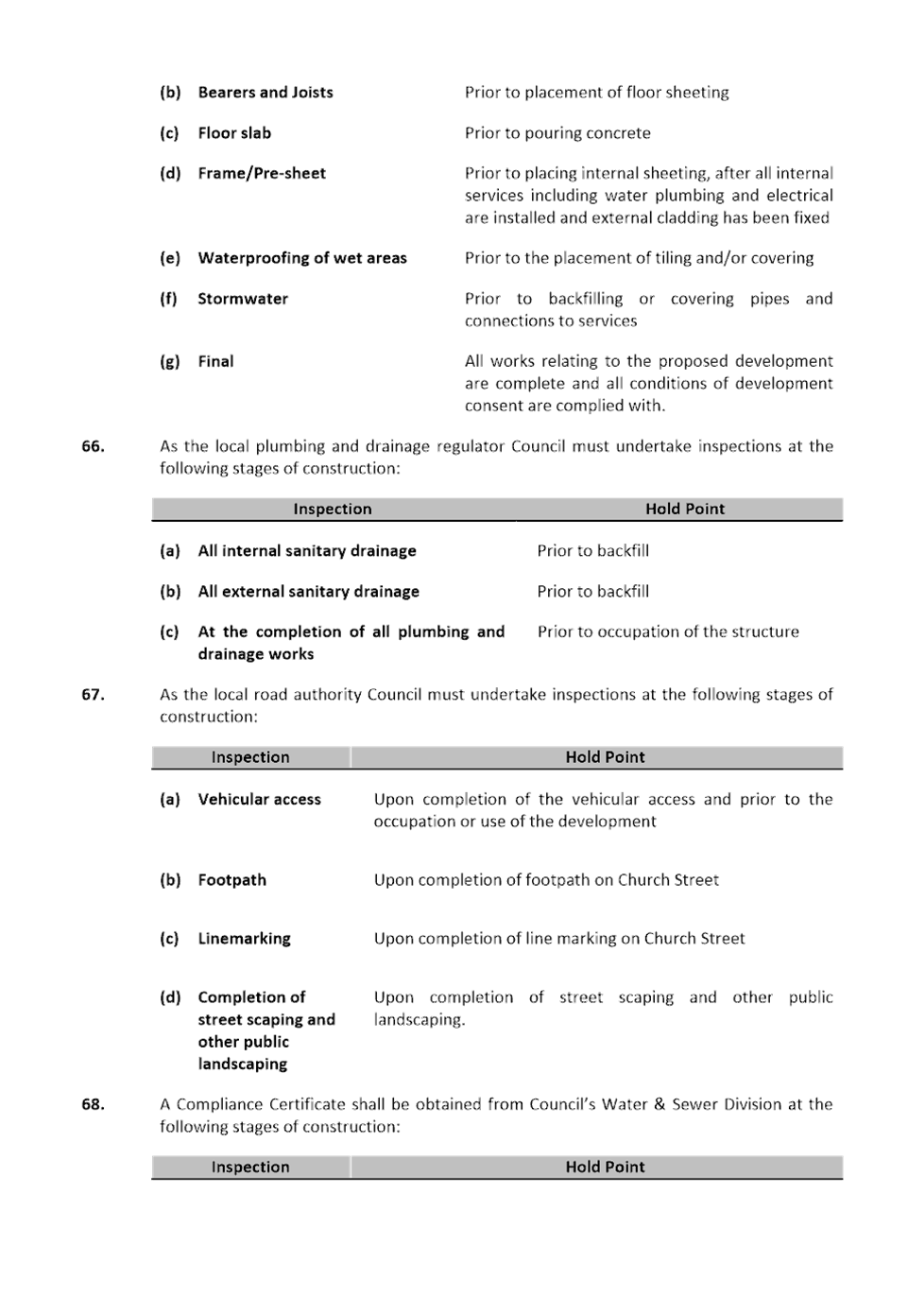

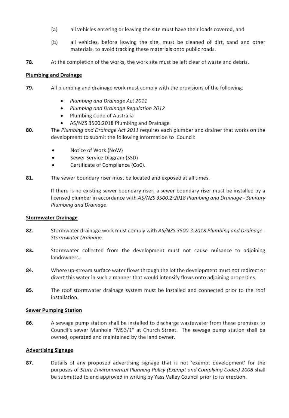
6.6 Development Application DA200091 - Eroision Gully Rehabilitation and importation of material - 64 Brooklands Road, Wallaroo
Summary
To present the assessment of Development Application No DA200091 for erosion gully rehabilitation including importation of 42,000m3 of material at 64 Brooklands Road, Wallaroo. The application attracted a total of 23 submissions and relevant concerns can be addressed via conditions. Approval is recommended.
|
That conditional Development Consent be issued for Development Application No DA200091 for erosion gully rehabilitation including importation of 42,000m3 of material at 64 Brooklands Road, Wallaroo |
FINANCIAL IMPLICATIONS
Resources for development assessment are provided for in the current Operational Plan.
POLICY & LEGISLATION
· Environmental Planning & Assessment Act 1979
· Environmental Planning & Assessment Regulation 2000
· Protection of the Environment Operations Act 1997
· Protection of the Environment Operation (Waste) Regulation 2014
· Water Management Act 2000
· Biodiversity Conversation Act 2016
· Yass Valley Local Environmental Plan 2013
· Resource Recovery Exemption – Excavated Natural Material Exemption 2014
· Resource Recovery Order – Excavated Natural Material Order 2014
· Resource Recover Exemption – Reclaimed Asphalt Pavement 2014
· Resource Recovery Order – Reclaimed Asphalt Pavement 2021
· Yass Valley Heavy Haulage Section 94 Contributions Plan 2006
· Yass Valley Heavy Haulage Development Contributions Plan 2021
· Enforcement Policy
· Filling Policy
· Community Engagement Strategy
REPORT
1. Application Details
|
Date Received |
- |
21 May 2020 |
|
Land |
- |
Lot 6 DP 1261120, 64 Brooklands Road, Wallaroo |
|
Area |
- |
24ha |
|
Zoning |
- |
RU1 Primary Production |
2. Site Description and Locality
The subject site is located on Brooklands Road, Wallaroo, just west of the intersection with Southwell Road. The surrounding area is rural and rural lifestyle, with a mix of holdings and property sizes. Land uses relate to both agricultural activities and rural lifestyle, including wineries, an olive grove, and residential dwellings. The Murrumbidgee River is located approximately 3km to the west.
The erosion gully dissects a large part of the lot. It includes the head of the erosion gully which then extends into the adjoining 66 Brooklands Road and further downstream. The site does not currently contain a dwelling house or any significant buildings. Access is via a driveway on Brooklands Road.
A Locality Plan is included in Attachment A.
3. Proposal
The application involves the rehabilitation of an erosion gully and the construction of an internal access road, including the importation of up to 42,000m3 of material.
A similar Development Application DA200109 at the adjoining 66 Brooklands Road which included the importation of up to 8,000m3 was approved by Council at its meeting in March 2021. It should be noted that the two applications were lodged within a fortnight of each other, exhibited concurrently and involve the same gully.
Details of the proposal are included in Attachment B.
4. Public Exhibition
The application was notified to landowners surrounding the subject land and with direct frontage to Southwell Road and Wallaroo Road on the transport route.
There were 17 submissions received, generally raising concerns or objection however a small number of submissions state in principle support but note concerns or qualified support with conditions
A Planning Forum was held in February 2021 to provide an opportunity for submitters and the Applicant to address Councillors prior to further formal consideration of the proposal. This occurred via Zoom with five presentations including the Applicant.
The key issues raised in the submissions and at the planning forum relate to:
· Inconsistent references to subject land in documents
· Purpose of project, methodology and alternatives
· Volume of material
· Truck movements and transport route
· Noise and amenity impacts
· Road standards and safety
· Road impacts and heavy haulage contributions
· Internal access road
· Consent conditions and monitoring
· Material quality
· Downstream water flows
· Ongoing filling activities in Wallaroo
Additional information was also exhibited to those who had previously made submissions with opportunity for further comment. There were six supplementary submissions received, including five raising concerns or objections (one contained a noise impact assessment), and one stating that they had no further objection provided the project did not have a detrimental impact on the environment.
One submission stated that they had not received written notice of the application despite being in immediate locality. This property did not receive written notice due to their subdivision having recently been completed and title details changing, which had not updated in the mapping system used to generate application notifications.
All submissions are included as Attachment C.
5. Referrals
The application was referred to the Natural Resources Access Regulator (NRAR) as integrated development as the work being undertaken is in a watercourse for the purposes of the Water Management Act 2000. NRAR have provided their general terms of approval (refer Attachment D).
6. Assessment
An assessment of the proposal has been completed in accordance with the Planning Legislation. The proposal generally complies with the relevant planning controls, policies and guidelines.
The following planning issues have been identified including the response to the issues raised in submissions.
6.1 Subject Land
The submissions state that the subject land is inconsistently identified in the supporting documents, including being referred to as both 64 Brooklands Road and 110 Southwell Road, along with different lot and DP numbers.
The land has been subject to a subdivision which was registered in April 2020. Some of the supporting documents appear to have been prepared prior to the subdivision being completed and therefore refer to the previous details.
The subject land is Lot 6 DP 1261120, 64 Brooklands Road.
6.2 Purpose of Project, Methodology and Alternatives
The purpose of the project and the adopted methodology has been questioned in the submissions, including suggestions that:
· The proposed filling is unnecessary and there may be other methods to manage or rehabilitate the erosion gully
· It is primarily for the purposes of disposing of development material from the ACT (i.e. financially motivated)
· There are questionable environmental benefits
The application states that the purpose of the gully rehabilitation is to improve environmental outcomes, outlining that there are major areas of ongoing active erosion. The project justification is that the rehabilitation will be beneficial to downstream environments, reducing the sediment and nutrient load that enters the watercourse, and improve agricultural productivity and management.
The report also notes that soil erosion control earthworks completed by the then Soil Conservation Service attempted to stabilise the site to divert flows from the gully head, however there are areas that remain active. Submissions also suggest that it is the landowner’s own actions, including works to the dam and farm management practices, which have exacerbated the erosion issue.
Questions were raised in the submissions about the methodology, whether alternative options are available and suggest that the proposed method appeared inconsistent with the Local Land Services’ Gully Erosion Assessment & Control Guide.
The rehabilitation plan considers the effectiveness of other options, recommending that the upgrade of existing permanent erosion control earthworks in conjunction with areas of filling. The earthworks include extension of existing diversion banks and installation of a rock rip rap structure to return concentrated flows back to the gully without causing erosion. The entirety of the gullies will not be filled, rather it is primarily the areas upstream of the dam.
The other options considered in the rehabilitation plan include:
· Continue existing land management (do nothing)
· Fence, destock and revegetate
· Upgrade Erosion Control Earthworks (no gully filling)
The upgrade of erosion control earthworks with no gully filling could also be an option which results in a net improvement in environmental outcomes and a reduction in sediment leaving the site. This has not been recommended as the preferred option due to the extent of upgrade to the erosion control earthworks and a net adverse impact on farm productivity as a result of capital cost, ongoing maintenance, and that it will not alleviate the farm management issues presented by the eroded area.
Concern was also raised that the effectiveness of this project cannot be ensured unless suitable steps for long-term stabilisation are also undertaken. The rehabilitation plan recommends a staged approach with each gully cell progressively rehabilitated, and with all fill areas covered in top soil, fertilised and seeded on completion. The area downstream of the dam which is not being filled is proposed to be fenced out and destocked to prevent further erosion.
The methodology is similar to previous proposals considered by Council. Conditions of any approval that may issue can require a statement from an appropriate person (with qualification and knowledge in soil conservation practices) confirming that each stage of rehabilitation has been completed in accordance with the rehabilitation plan.
It is also considered appropriate rehabilitation of the erosion at 64 Brooklands Road will have downstream benefit at 66 Brooklands Road and overall improving the outcomes of that project.
The supporting documentation notes that Canberra construction companies will contribute financially to the project. Any direct commercial or financial incentives are not a valid planning consideration.
In terms of the characterisation of the proposal under the LEP, it is considered that the proposal is filling/earthworks for the purpose of ‘environmental protection works’. The area is actively eroding and the proposal is seeking to address this.
At time of writing this report, an Objector has also provided a peer review of the Applicant’s Gully Rehabilitation Plan. This report raises some concerns with the methodology and level of detailed provided however it did not have the benefit of reviewing draft conditions or the General Terms of Approval from the NRAR. The report concludes that the proposal involving filling might be feasible, however the application does not contain sufficient background information or planning detail to enable Council to grant approval. The additional detail identified would be required via any Consent conditions or the General Terms of Approval from NRAR. For any approval that may issue conditions can be further revised to reflect the author’s recommendations i.e.
· A Revised Gully Rehabilitation Plan to be submitted prior to the commencement of works addressing the specific issues, including how soil chemistry will be managed, measures to be put in place to prevent erosion of the diversion banks, and details whether repairs to existing diversion bank are necessary
· Engineering design details and calculations are to be provided prior to the commencement of works for then proposed rock/concrete flume and diversion banks
The General Terms of Approval from NRAR require the following to be submitted to them the Controlled Activity Approval application:
· A sediment and erosion control plan to be prepared in accordance with Landcom 2004 and submitted to them as part of the Controlled Activity Approval
· A Construction Environmental Management Plan, including monitoring
· A revegetation plan
In this regard, this level of detail is not required to determine the Development Application given that NRAR have issued General Terms of Approval without it and require it with the Controlled Activity Approval application. This is consistent with consideration of similar proposals.
6.3 Volume of Material
The volume of material required to complete the project has been calculated by survey at approximately 42,000m3 (63,000 tonnes).
In the submissions received it was highlighted that a note on the survey plan indicates that it had not been confirmed by survey. It is understood that this statement is a standard disclaimer note on the plan which the survey had been laid over for illustrative purposes. However, the Applicant’s surveyor has stated that the contours were derived by survey and are of the current surface requiring rehabilitation. Upon receipt of the Gully Rehabilitation Report and the defined three areas requiring filling we created an undulating finished surface level to be sympathetic with the surrounding topography and each of the specific areas had a volume calculated from the existing surface to the designed finished level.
For further clarity, Consent conditions can require the Applicant to provide an updated plan which shows the AHD level for the major contours. The volume of material imported can then be confirmed by subsequent surveys in conjunction with delivery records.
In determining DA200109 for the rehabilitation project at 66 Brooklands Road Council resolved to include a requirement for a survey to be undertaken six months from commencement of works, or at the importation of approximately 4,000m3 of material, whichever occurs first. It is suggested that this requirement be included and a requirement for survey at the completion of each of the three stages.
6.4 Truck Movements and Transport Route
The volume of material proposed to complete the erosion gully rehabilitation project is approximately 42,000m3 or 63,000 tonnes.
The estimate for the number of trucks will vary depending on the configuration of the vehicles and their payloads. The supporting documentation estimates that the total number of truck movements (i.e. loads – a delivery in and out) would be 2,334, based on 27 tonne truck and dog combinations. In assessing similar applications, Council has previously adopted the assumption that all deliveries would be truck and dog combination with 33 tonne payload. The movement assumption is presented below:
|
|
Estimate @ 27t (In and Out – 63,000t) |
Estimate @ 33t (In and Out – 63,000t) |
|
Total Movements |
2,334 movements |
1,909 movements |
These are estimates only and the exact number of truck movements will depend on the delivery vehicles and combinations, the bulking factor for each load, the available of source material and weather conditions. It is therefore likely that there will be periods of movement and periods of none.
The most recent traffic count data for Wallaroo Road is from 2018 at the NSW/ACT border. This was a three week count and indicated that 40% of vehicles were heavy vehicles. An earlier 2011 traffic count indicated a lower percentage of heavy vehicles.
|
Location |
ADT |
HV # |
HV % |
|
NSW/ACT Border 2018 |
1,284 |
524 |
40.8 |
|
NSW/ACT Border 2011 |
1,241 |
137 |
11 |
Council has generally limited movements associated with this type of project to 20 per day (i.e. loads). However, in considering DA200109 for 66 Brooklands Road, Council restricted the number of movements per day to eight. The recommendations in the noise assessment peer review is 10 movements per day. It is suggested that Council again limits movement to eight per day.
Limiting the movements to maximum of eight per day would mean that it would take in vicinity of 240-300 days at maximum haulage to complete the project, based on assumed truck and dog combinations presented above.
Eight deliveries per day would represent a 3% increase in heavy vehicle movements into Wallaroo based on the 2018 traffic count. If a maximum eight deliveries per day were included for adjoining DA200109 for 66 Brooklands Road, this would be a combined increase of 6%. The 2018 traffic count data suggests a high percentage of heavy vehicle traffic on Wallaroo Road, similar levels Kaveneys Road.
The percentage increase in heavy vehicle movements is greater closer to the development site, i.e. along Southwell Road, however the traffic count data for both Southwell Road and Brooklands Road is historic, being from 2011 and 2005.
The Traffic Impact Assessment did not provide updated traffic data. Submissions detail a manual traffic count undertaken by residents one day in March 2021 that shows heavy vehicle movements into Wallaroo are considerably less than the 2018 traffic count. However, submissions then also cite instances where there have been dozens of heavy vehicles an hour into properties on particular days. This highlights the limitations of traffic data in capturing the complete picture of heavy vehicle movements, noting that it has often been sporadic and has been particularly varied over the last two years around COVID restrictions.
The transport route is to be via Wallaroo Road, left onto Southwell Road, and then right onto Brooklands Road, with the reverse on the return trip. Submissions request that the transport route on the return trip be via Goroomon Ponds Road to distribute impacts of truck movements. Gooromon Ponds Road has a five tonne load limit and therefore could not be used as a through route for heavy vehicles under the NSW Road Rules.
6.5 Noise and Amenity Impacts
Noise associated with the proposal and its impact on local amenity has been identified. The submissions received and representations made at the Planning Forum identify that the movement of heavy vehicles impacts on amenity particularly for the Southwell Road properties.
The Applicant was requested to provide a noise assessment (refer Attachment B) which concluded that:
· Construction noise levels are likely to comply at most receivers except for two receivers but who would not be expected to exceed highly affected noise levels
· Noise levels associated with traffic movements at the most exposed receiver would satisfy criteria
However, a second noise assessment was submitted by an objector as part of a supplementary submission (refer Attachment C). The second noise assessment raised questions with the methodology and conclusions reached in the Applicant’s noise assessment being:
· The Noise Impact Assessment is fundamentally flawed in relation to the method use for predications of construction noise and the levels stated in the report are not representative of the true impact on nearby sensitive receivers
· That with a more accurate calculation method it is likely that the noise levels will be up to 8dB above the allowed level in the Interim Construction Noise Guideline
· That an unsuitable metric was used to assess road traffic noise
· That the subjective noise impact from heavy vehicle movements due to their intermittent nature (within an average period) is far greater i.e. short, loud noises in an otherwise low ambient noise environment
· That the traffic noise that would arise from the proposal would be above limits which the EPA considers acceptable to residents and would be sufficiently high to disrupt conversations outside of dwelling as heavy vehicles pass
· That there would be a loss of amenity experienced by sensitive receivers being contrary to the aims and objectives of the Yass Valley Local Environmental Plan 2013
Council staff engaged a noise consultant to provide a peer review on the methodology and conclusions of the two noise assessments, whether the noise impacts were acceptable or otherwise and/or any necessary conditions required if appropriate (refer Attachment E). The conclusions and recommendations from Council’s noise consultant are as follows:
· Construction noise impact does not provide sufficient grounds to refuse the proposed works, but conditions of Consent are necessary to ensure all feasible and reasonable measures are taken to reduce noise impacts, including:
- All work and heavy vehicle movements restricted to 9am-4pm on weekdays
- Heavy vehicle movements associated with the site be restricted to 10 per day in each direction (i.e. 10 loads). However, note here that it proposed to limit the movements to eight per day in each direction
- Mobile plant used on site to be restricted and the power level checked by qualified acoustic engineer
- Work practices and consultation/complaints handling procedure be implemented as outlined in Applicant’s noise impact assessment
· Noise levels from proposed movements of heavy vehicles on public roads are within relevant published criteria. The adoption of any alternative noise criteria as outlined in the objector’s noise assessment, should be considered only after a formal assessment and research process. The effect of adopting any alternative criterion on the assessment impacts could not be guaranteed
Based on the above, it is considered that the proposed development will not have an adverse noise impact to sensitive receivers to an extent which would warrant the Development Application being refused. All recommendations from Council’s peer review can be incorporated as conditions of any Consent that may issue.
6.6 Road Standards and Safety
Concern is raised in the submissions about the standard of the roads on the transport route and road safety, particularly:
· Road width
· Uneven and deteriorating pavement
· Sharp pavement edge
· Lack of line marking
All roads to the site are two way and sealed with a limited shoulder. Southwell Road and this section of Brooklands Road do not have a marked centreline. There is a school bus that travels Wallaroo and Southwell Roads, and the Wallaroo area is a popular area for cyclists and occasional horse riders.
Council has inspected the roads and note that the pavement along the transport route is deforming in areas. There has been some patching undertaken since receipt of the submissions however equally there are now other areas of deformation and potholes, particularly given recent wet weather.
Within the submissions there is also a request for a centre line to be painted on Southwell and Brooklands Road. This was not required for adjoining DA200109 due to the relatively small scale of the proposal however Council has required an Applicant for gully rehabilitation project on Kaveneys Road to paint a centreline.
It has also been identified that the corner when turning left from Wallaroo Road into Southwell Road is in poor condition as it has been cut out by heavy vehicles. To assist in ensuring the safety of heavy vehicle movements around this corner it would be appropriate that a condition of any Consent require rehabilitation of the pavement in that corner prior to commencement of the importation of material.
The Applicant has outlined that their heavy vehicles will travel at a maximum of 80km/hr. Within the submissions there is a request that heavy vehicles associated with development be limited to 50km/hr along the transport route from the Barton Highway. This is not appropriate given that speed limits are managed under the NSW Road Rules and enforced by NSW Police. However, a transport management plan combined with enforcement of road rules by NSW Police, is appropriate.
Conditions of any Consent that may issue can limit heavy vehicle movements to Monday to Friday and exclude public holidays. This will assist in reducing potential conflicts between weekend tourist traffic and recreational road users. Conditions can also require a transport management plan to be prepared by the Applicant and needs to cover aspects such as school bus times and consideration of other road users.
There were a couple submissions made by property owners which raised concerns that their driveway was a concealed entry posing a safety risk. A site inspection did not identify these driveways as a significant safety risk.
6.7 Road Impacts and Heavy Haulage
Several of the submission question the financial cost of heavy haulage on the road network and the opportunity for this to be recovered from the Applicant. They also highlight that Wallaroo residents contributed financially to the sealing of roads in this location, and request that compensation be paid to affected residents who funded original sealing.
Council has recently adopted the Yass Valley Heavy Haulage Development Contribution Plan 2021. However, when the Application was lodged the Heavy Haulage Section 94 Contribution Plan 2006 applied. The 2021 Plan states where an application has been submitted prior to the adoption of this Plan but not determined, the application shall be determined in accordance with the provision of the plan which applied at the date of the submission of the application. Therefore the 2006 Plan applies to this Application.
The contribution under the 2006 Plan will be $6,985 based on the 63,000 tonnes to be hauled (refer Attachment F).
6.8 Internal Access Road
A sealed internal access road is proposed to be constructed from the Brooklands Road driveway to the erosion gully.
Design details of the internal access road need to be submitted for approval prior to commencement of construction. The internal access road will need to be completed prior to the commencement of importation of fill material.
6.9 Consent Conditions and Monitoring
It is suggested that standard Consent conditions (i.e. those used on similar Development Consents) should be used in any approval that may issue, including those which reflect Council’s determination of similar DA200109 at 66 Brooklands Road i.e.:
· Trucks importing material to this site are to display a clear marking (i.e. coloured sheet in window with DA number or magnetic identifier) identifying that they are associated with this development. In considering DA200109 for 66 Brooklands Road, Council resolved to require these identifications to be 1m x 1m front and rear. This is not recommended as it is not practical to install an identifier of this size on the cab of a truck (has been raised as an issue by that Applicant). The size and location of the markings just need to be sufficient that they can be easily identified
· The Applicant is to prepare a project status report every six month months during the duration of the project
· Fill delivery records are to be included in the project status report or are to be made available to Council within seven days upon request. The fill delivery record is to include an excel spreadsheet with the information entered, along with a copy of any hand written delivery record sheets
· A project transport management plan to be prepared by the Applicant prior to commencement of activities. This can form part of the briefing provided to truck drivers and cover aspects such as minimising use of air brakes, school bus times, points of potential conflict on the transport route (e.g. driveways), speed limits, expected driver behaviour, etc
· Evidence that power levels of mobile plant to be used on site have been checked by a qualified acoustic engineer is to be submitted prior to commencement of works
· A final project completion report or statement shall be prepared by someone suitability experienced and qualified to confirm that the proposal has been completed in accordance with the project report
6.10 Material Source and Quality
The submissions question how the quality of the material can be ensured during the project.
The project proposes to utilise virgin excavated natural material (VENM) and excavated natural material (ENM), with the ENM consisting of at least 98% VENM. A resource recovery exemption (RRE) and resource recover order (RRO) issued by the NSW EPA under the Protection of the Environment Operation (Waste) Regulation 2014 allows the use of ENM in earthworks, subject to specific requirements for source testing.
The applicant will need to have appropriate documentation to confirm the classification is VENM or ENM for NSW legislation should the proposal be approved. Evidence of this classification must be submitted upon request.
The implications of the use of acidic soils has been raised. The definition of ENM expressly excludes material which contains acid sulphate soils, potential acid sulphate soils, or sulfidic ores. This would be picked up by the required testing. Some variation in soil composition compared to immediately surrounding is not considered to have any adverse downstream impacts. This has also been clarified with the Applicant’s consultant who has advised that the majority of topsoil to be used to dress the areas filled will be recovered (stockpiled) from the site initially and then reapplied in the revegetation so that it does not vary significantly from the in-situ. However, a revised Gully Rehabilitation Plan which includes an in-situ soil test and details how soil chemistry will be managed is included in the draft conditions.
6.11 Downstream Water Flows
Concern has been raised in a submission as to whether the erosion gully rehabilitation will result in reduced water flows downstream.
The proposed gully rehabilitation at 64 Brooklands Road will not result in any significant changes to the volume of downstream flows, noting that the overland flows are proposed to be redirected to below the dam where it will re-enter the gully channel. The maximum harvestable rights for individual properties are dealt with under the Water Management Act 2000 and does not change as a result of this proposal.
The submitted gully rehabilitation report notes that flocculation of the dam may be required to manage turbidity levels. This is to be overseen by the nominated environmental manager and details of the actions taken for this documented in the six-monthly and final status reports.
Where the erosion has been successfully addressed then there will be an improvement in downstream water quality.
6.12 Filling Policy
At time of the application being made the Filling Policy had been exhibited and was subsequently adopted by Council in September 2021.
The policy has weight consideration for this application. The proposal is however generally consistent with the requirements of the policy. The Applicant has sought professional advice on the erosion issue, the design of the works and the available options. Any environmental outcomes have been considered alongside potential adverse impacts on the amenity of neighbouring properties in the assessment presented.
6.13 Other Issues
The submissions raise concerns in relation to other activities on land owned by the Applicant in the immediate area, including:
· Truck depot
· Asphalt storage
· Helicopter pad
· Moved boundary fence at 225 Southwell Road
The truck depot and helipad are currently under investigation and the boundary fence at 225 Southwell Road was considered by Council in October 2021. These matters are both outside of consideration for the Development Application.
Council is aware that a large pile of asphalt was being stored on the subject property. The site was inspected with the NSW EPA and it was determined that the volume of the asphalt storage did not exceed the weight or volume thresholds which would trigger the need for licensing by the EPA under the Protection of the Environment Operations Act 1997. However, it was identified there was no Development Consent in place for the use of the land. In September 2021 the landowner started removing the asphalt and approximately half has been removed. It is understood some of the asphalt is proposed to be used on the internal access road to the erosion gully and evidence will be required that this material has been tested and is suitable in accordance with the RRO and RRE prior to its use.
7. Other Filling Activities and Ongoing Action
Ongoing community representations have assisted in identifying other filling activities occurring in the Wallaroo area. These have been investigated and followed up as they arise. These matters do not relate to the consideration of this Application.
8. Conclusion
From the assessment of the proposal and consideration of issues raised in submissions, it is recommended that a Development Consent be issued. Draft conditions are included in Attachment G.
Strategic Direction
Theme 1. – Our Environment
Long Term Goal EN4 – Maintain a balance between growth, development and environmental protection through sensible planning
Strategy EN4.2 – Ensure development application assessment is thorough and efficient
Strategic Action EN4.2.1 – Implement the development process and implement changes aligning with the NSW Government’s best practice guidelines.
ATTACHMENTS: a. Locality Plan ⇩
b. Supporting Documents (Under Separate Cover) ⇨
c. Submissions (Under Separate Cover) ⇨
d. NRAR General Terms of Approval ⇩
e. Noise Assessment Peer Review ⇩
f. Heavy Haulage Calculations ⇩
g. Draft Conditions ⇩
6.6 Development Application DA200091 - Eroision Gully Rehabilitation and importation of material - 64 Brooklands Road, Wallaroo
Attachment a Locality Plan
6.6 Development Application DA200091 - Eroision Gully Rehabilitation and importation of material - 64 Brooklands Road, Wallaroo
Attachment d NRAR General Terms of Approval
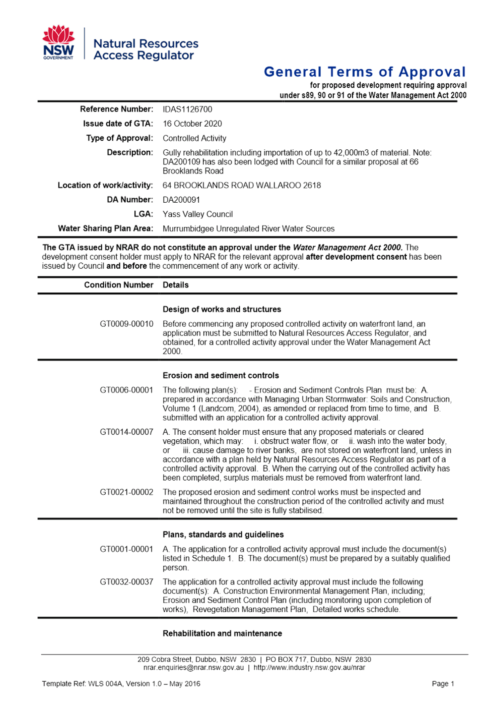
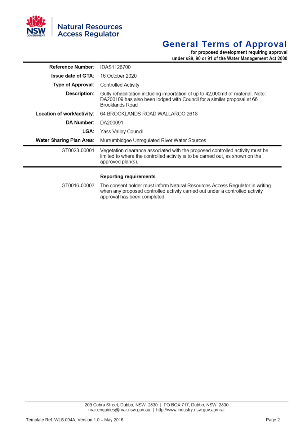

6.6 Development Application DA200091 - Eroision Gully Rehabilitation and importation of material - 64 Brooklands Road, Wallaroo
Attachment e Noise Assessment Peer Review
6.6 Development Application DA200091 - Eroision Gully Rehabilitation and importation of material - 64 Brooklands Road, Wallaroo
Attachment f Heavy Haulage Calculations
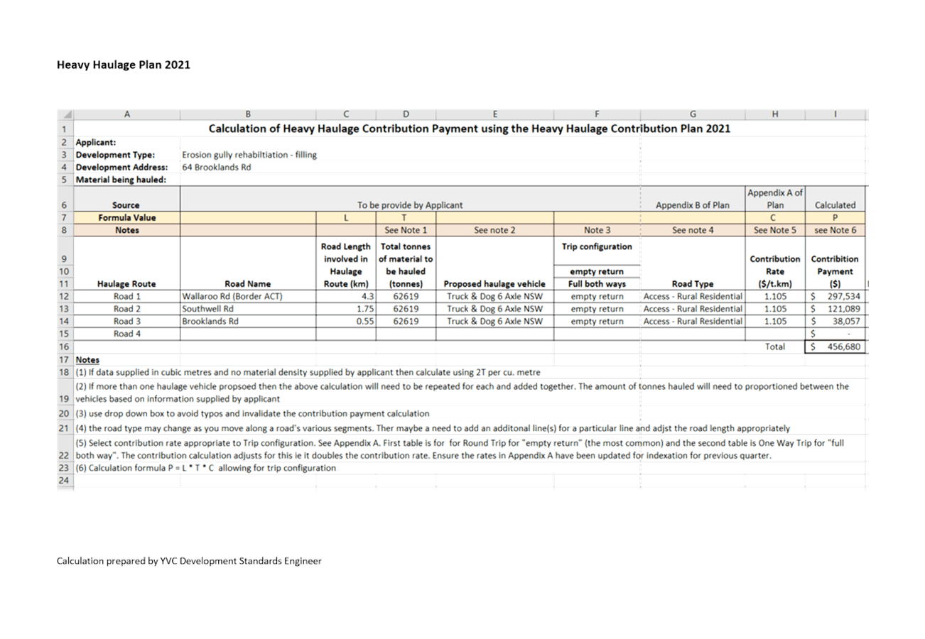
6.6 Development Application DA200091 - Eroision Gully Rehabilitation and importation of material - 64 Brooklands Road, Wallaroo
Attachment g Draft Conditions

The Local Government Act 1993 permits Council to establish an Alcohol Free Zone (AFZ). The last AFZ was established in March 2016 and expired in March 2020. It is recommended the AFZ be re-established in the Yass main street (CBD) area.
Cost of 20 new signs (approximately $1,000). non-licenced business (BYO) who allow patrons to consume alcohol in the footpath area whilst partaking of a meal.
· Local Government Act 1993
· Ministerial Guidelines on Alcohol Free Zones (February 2009)
· Community Engagement Strategy
1. Proposal
At is meeting on 22 September 2021, Council resolved to exhibit a proposal for the Yass AFZ and if no significant objections were received, the Yass AFZ was to be established for a four year period. Attachment A shows the extent of the Yass AFZ.
Exhibition of the Yass AFZ has now been completed and three submissions were received.
2. Exhibition
As part of the exhibition, all licensees within the proposed AFZ, the Onerwal Local Aboriginal Land Council, the NSW Aboriginal Land Council, NSW Police and the general public were notified. Submissions closed on 12 November 2021.
Three submissions were received, being the Yass Valley Business Chamber, NSW Police and a local business owner (refer Attachment B).
3. Submissions
The NSW Police Force supported the re-establishment of the AFZ. The other two submissions objected to the proposal. The following issues were identified:
· The introduction of an AFZ would be detrimental to the growth and flourishment of hospitality businesses in Yass
· A lack of consultation with businesses
· Objection to the whole street being included
· Lack of supporting evidence and seeking a clearer explanation of the benefit of the AFZ
· Lack of Council encouragement for serving alcohol on footpaths
· An option to have the AFZ time based (suggested 9pm to 9am) rather than a blanket 24 hours
· The decision of establishing an AFZ should be delayed until the completion of the Yass CBD Masterplan and after the forthcoming December Council elections
4. Response to Submissions
4.1 An AFZ would be detrimental to the growth and flourishment of Yass hospitality based businesses
The introduction of the AFZ is not designed to be detrimental to businesses. It is proposed to support the NSW Police in reducing unruly behaviour, property damage and assault.
Approval can be given to both licenced businesses to serve alcohol in the footpath area adjacent to their business in accordance with their liquor licences and to non-licenced business (BYO) who allow patrons to consume alcohol in the footpath area whilst partaking of a meal. The recommendation to Council is that these businesses be given a blanket exemption from the AFZ during their business hours.
4.2 Lack of consultation
The proposal was placed on public exhibition by Council. The consultation included the Council website and social media. In addition, all licensees within the proposed AFZ, the Onerwal Local Aboriginal Land Council, the NSW Aboriginal Land Council, NSW Police and the general public were notified. Council also attended the Liquor Accord meeting to discuss the proposal.
4.3 Objection to the whole street being included
It is proposed that the whole street (CBD as per the map) be included to assist Police with their role. This is consistent with the previous AFZ.
4.4 Lack of supporting evidence and seeking a clearer explanation of the benefit of the AFZ
NSW Police support the introduction of the AFZ indicating that it is a vital tool in assisting them to reduce the occurrence of alcohol related incidents. Further, it was reported that NSW Bureau of Crime Statistics and Research shows the rate of alcohol related assaults in public places in Yass for the 12 months ending June 2021, is higher than the State average (89.7 per 100,000 population, compared to 79.7 per 100,000).
A recent example cited by the NSW Police and outlined in their submission details an incident on 6 November 2021. Yass Police responded to an incident of alcohol related disorderly behaviour in Comur Street which involved persons consuming alcohol within the proposed AFZ. However, as the AFZ is not currently enforceable, Police were unable to seize the alcohol. Less than three hours later this intoxicated individual, was involved in an assault whilst still consuming alcohol within the proposed AFZ.
The NSW Police also advised that the recent Yass Liquor Accord meeting passed a motion in support of the introduction of the AFZ.
4.5 Lack of Council encouragement for serving alcohol on footpaths
Outdoor dining on footpath areas adjacent to businesses who either have a liquor licence or allow BYO for patrons to consume whilst they partake of their meal is supported. This will assist to continue to develop a vibrant CBD particularly over the warmer months, weekends and holiday periods.
4.6 An option to have the AFZ time based (suggested 9pm to 9am) rather than a blanket 24 hours
Whilst there is an option to have a time range included for the AFZ, this would not assist Police in addressing antisocial issues that arise during daylight hours.
4.7 The decision of establishing an AFZ should be delayed until the completion of the Yass CBD Masterplan
There is an existing Development Consent for the mainstreet that permits outdoor dining to be established. Lifting of the AFZ restrictions has been permitted for licenced premises during business hours (ie Yazzbar). The Yass CBD Masterplan will consider further options to encourage outdoor dining in the main Yass CBD. There is no need to delay the introduction of the AFZ pending the completion of the Masterplan.
5. Conclusion
From the assessment of the issues raised in submissions, it is recommended that the AFZ be re-instated for a period of four years and provide an exempt to blanket exemption from the AFZ for both licenced businesses to serve alcohol in the footpath area adjacent to their business in accordance with their liquor licences and to non-licenced business (BYO) who allow patrons to consume alcohol in the footpath area whilst partaking of a meal. This exempt would apply only during their business hours.
Key Pillar 3. Our Community
CSP Strategy CO3 - Foster and encourage positive social behaviours to maintain our safe, healthy, and connected community
Delivery Program Action CO3.4 - Develop a Crime Prevention Plan
Operational Plan Activity CO3.4.1 -
ATTACHMENTS: a. Proposed Alcohol Free Zone ⇩
b. Submissions to Alcohol Free Zone ⇩
7.1 Riverbank Park Adventure Playground
SUMMARY
To present the outcomes of the community survey for the Riverbank Park Adventure Playground to replace the playground at Riverbank Park under the NSW Public Spaces Legacy Program funding agreement.
|
That 1. The preferred playground concept design for Riverbank Park, Yass, be endorsed for further detailed design development based on the feedback provided during the community consultation 2. The existing playground equipment in Riverbank Park be removed as part of this project 3. The community be thanked for their involvement and participation in this process |
Financial IMPLICATIONS
Funding has been provided under the NSW Public Spaces Legacy Program to develop a design for the new adventure playground at Riverbank Park and included in the 2021/22 Operational Plan and identified for inclusion in the 2022/23 Operational Plan. There is no change to existing financial approvals due to this report.
POlicy & Legislation
• Local Government Act 1993.
REPORT
1. Background
Council has secured funding of $1,784,700 under the NSW Public Spaces Legacy Program to redevelopment the current playground site at Riverbank Park. The NSW Public Spaces Legacy Program is a State Government initiative that will fund new and improved high-quality public open spaces to ensure a legacy well beyond the COVID-19 economic recovery period by contributing to the health, wellbeing and economic growth of our community.
Stage One of the project involves Council developing concept plans to release to the community for feedback on a preferred option. The draft designs will incorporate the following:
• Adventure Playground (including a flying fox)
• Amenities Block (Toilets)
• Passive open space area
• BBQ facilities (to remain in existing location)
• Fitness Station (can be relocated)
• Internal access roads, pedestrian paths,
• Fencing, seating, waste receptacles
• Lighting
• Irrigation
• Signs (identification, directional)
2. Concept Plans
GroupGSA Pty Ltd was engaged to develop the concept designs for the Riverbank Park Playspace. An onsite meeting between Council staff and the consultants gave a clear understanding of the history of the location, the opportunities and constraints of the area and also feedback from previous community consultation of desired equipment.
Both concepts included a thematic approach and incorporate all physical areas of the Riverbank Park playspace while offering a variety of activities to engage a broad age group.
In September 2021 Council determined that the draft concept designs be placed on public exhibition, evaluated for preferred option and reported back to Council for adoption.
3. Community Consultation Outcome
Community consultation was undertaken through surveymonkey, which allowed the community to view both concept designs, advise their preferred option and provide additional commentary on the preferred design (i.e. what they did/didn’t like, what they would add/remove from their preferred design).
The survey was made available online between 14 October 2021 and 10 November 2021 through Council’s social media outlets and through signs installed around Riverbank Park.
Council has reviewed the survey results (refer Attachment A), and determined that by popularity of 54.5% the preferred concept design is Where the Wild Things Are (refer Attachment B).
The most appealing part of this design was the equipment (74%) followed by the activities (52%).
Survey results relating to the activities of the preferred design determined that majority of activities identified in the concept design are acceptable.
Survey results relating to the equipment of the preferred design determined that:
· 42% would remove the spinning net and climber
· 59% would remove the springer
· 58% would add the embankment slide
· 40% would add the carousel
Council also received comments relating to other areas being:
· Shade/Shade sails - 16%
· Fencing - 10%
· Water play - 10%
Following endorsement of the preferred concept design, staff will develop with the consultant the detailed design which will breakdown each designated area with specific equipment. Shade and fencing will be incorporated into this process.
Water play will not be considered in this playspace due to:
· Significant costs (approximately $80-$100k) associated with the installation and infrastructure (i.e. reticulation, filtration and wastewater) required to incorporate such features
· Additional cost for the maintenance required to service the reticulation and filtration infrastructure
· Riverbank Park being in a flood prone area which will add to the maintenance costs if flooding occurs
· The cold climate of Yass which adds to the maintenance costs when water freezes in the pipes and damages internal parts within the play equipment
· Additional inspection, maintenance and water testing costs related to approvals required through Public Health Act 2010 and Public Health Regulation 2012 (including Practice Note No. 15 – Water Safety 2017)
4. Conclusion
Based on the survey results, a preferred playground design (refer Attachment B) for the replacement of the existing equipment at Riverbank Park has been determined through the consultation process.
It is proposed that Council proceed to developing the detailed design for tendering and procurement requirements with consideration to the change of equipment, and addition of shade and fencing.
Key Pillar 4. Our Infrastructure
CSP Strategy IN4 - Maintain and update existing community facilities, and support the development of new community infrastructure as needed
Delivery Program Action IN4.1 - Develop and maintain new and existing recreational and community assets to address our communities needs in a sustainable manner
Operational Plan Activity IN4.1.1 - Maintenance of sporting fields and playgrounds in accordance with user group needs
ATTACHMENTS: a. Survey Responses ⇩
b. Where the Wild Things Are ⇩
Ordinary Council Meeting 1 December 2021
7.2 Yass Water Treatment Plant Upgrade Project Update
The Yass Water Treatment Plant Upgrade Project is an important and challenging project for the Yass Valley Council. Council requested bimonthly update reports be provided on the project.
RECOMMENDATIONThat the update report and work completed on the Water Treatment Plant Upgrade Project be noted |
Final approval of the Stage 1 Grant for $2.543m is still awaiting final sign off from Treasury.
· Local Government Act 1993
1. Background
The upgrade of the Yass Water Treatment Plant is being progressed in three stages:
1. Early Works package including: installation of bubble plume aeration at Yass Dam, upgrade of Raw Water Pump Station, and urgent works at Yass Water Treatment Plant
2. Major treatment plant upgrades
3. Rehabilitation of selected existing treatment plant process units
2. Progress to date
2.1 Stage 1 – Early Works
· Long lead time items including the compressor, dosing skids, electrical switchboards, and water quality instrumentation have all been ordered.
· Installation works packages have been completed and have been tendered in 3 packages which are all due to close prior to the end of 2021 for works beginning early in 2022:
- Electrical and mechanical installation
- Civil Works
- Integration of control systems
· Funding Grant for delivery of the works has been agreed by HAF and Infrastructure NSW and is awaiting approval from Treasury
2.2 Stage 2 – New Water Treatment Facilities
Design and business case development for Stage 2 works based on the recommendations of the Peer Reviewer is progressing. Currently awaiting final proposal from Hunter H2O for the completion of the design and business case. Meeting with DPIE reference limits of design required for tender and overall design development requirements.
2.3 Stage 3 – Rehabilitation of Existing Treatment Process Units
The Stage 3 design and business case tasks have not yet commenced and will recommence based on the recommendations of the Peer Reviewer once Stage 2 works have been consolidated.
2.4 Consultation with DPIE (Water)
· Council continues to consult with DPIE on Stage 1 designs and the Stage 2 development process. DPIE have provided additional design guidance on the bubble plume aeration system
3. Next Steps
· Complete the civil and electrical/mechanical tender process for Stage 1 Construction
· Complete orders for long lead-time items for Stage 1 Construction
· Liaise with Infrastructure NSW to enter into a funding Deed of $2.543M for Stage 1 Construction
· Progress with Stage 2 and 3 Concept Design, Detailed Design and Business Case
· Liaison and procurement for additional land for expanding the WTP site
Key Pillar 4. Our Infrastructure
CSP Strategy IN5 - Ensure high quality water supply options for the towns in the region
Delivery Program Action IN5.1 - Council to supply quality water, cater for growth and quality enhancements that addresses the community needs
Operational Plan Activity IN5.1.5 - Prepare design and business case for Yass Water Treatment Plant upgrade (Stages 2 and 3)
Ordinary Council Meeting 1 December 2021
7.3 Lease Request - Former Pool Manager's House
Yass FM have submitted a request for a short term lease the former Pool Managers House for radio transmission studio.
Reduction in income adjusted in second quarter budget review.
· Council Leasing Policy
Background
A request has been received from Yass FM to lease the Pool House located at Victoria Park as an interim measure until a final solution on their location can be determined.
Council was advised that the current tenant of the Pool Manager’s House, located in the Victoria Park precinct, was becoming vacant on 17 November 2021. Discussions between Council and Yass FM Committee to ascertain suitability for a short term lease (refer Attachment A) have indicated that Yass FM could occupy the site for a short period to enable time to develop a long term solution. Yass FM Executive Committee and Council staff have been working together to find an interim solution for accommodation since the 6 May 2021 when the Old Water Treatment building was deemed unsafe for use.
With the pool house becoming vacant and Council receiving a correspondence from the Yass FM President requesting use of the house on a short term basis (12 months) to enable presenters to get back on air and ease the workload on presenters in pre-recording programs. It would also give Yass FM a physical presence within the LGA.
As the house falls within the footprint of the proposed new indoor pool site, Yass FM would need to relocate earlier than anticipated if any works on a new facility would not be compromised or hindered if they were to start within the lease period.
The Victoria Park Crown Reserve allows for use of this area by community organisations/groups, hence the use of the house on a short term basis by Yass FM are within the permissible use. This would allow Yass FM to occupy the building and setup a studio without great expense until plans can be progressed for Yass FM to relocate to the land adjacent to the Men’s Shed at the Community Centre.
Current market housing rental is in the vicinity of $300 per week. A private residential tenancy agreement on the house would need to be identified in a Plan of Management for the precinct and approved by Crown Lands. The Victoria Park Masterplan and any future Plan of Management would not seek to use the house for a private rental.
Previously when the house was unoccupied it was subject to damage due and break-ins and the premises being used for unsocial behaviour. Allowing the building to be used by Yass FM for a short period while changes are made to the Plan of Management will ensure the building does not become a place for unsocial behaviour.
Proposal
Yass FM are proposing rental of up to $50 per week, noting that the station makes a considerable contribution to publishing Council issues and the welfare of the Yass Valley Community, and the COVID-19 has resulted in a reduced capacity for sponsorship and fundraising efforts. Yass FM will meet the costs of utilities where metered separately (electricity).
Yass FM in consultation with Council staff, will undertake to develop a plan and Development Application for permanent premises next to the Men’s Shed with a view to moving to the site in the long term as outlined in the Yass FM supporting documentation (refer Attachment B).
Strategy
Providing a short- term option will enable the longer-term goal of relocating the station to a purpose built premises on a long term lease. It will facilitate the station’s continued operation and shore up its ability to gain funding from grants and the wider community to build the long term home.
Key Pillar 4. Our Infrastructure
CSP Strategy IN4 - Maintain and update existing community facilities, and support the development of new community infrastructure as needed
Delivery Program Action IN4.2 - Ensure sufficient land is appropriately located for future Council facilities and emergency services
Operational Plan Activity IN4.2.1 -
ATTACHMENTS: a. Yass FM Lease Request ⇩
b. Yass FM Supporting Information ⇩
8.1 Annual Financial Statements 2020/21
SUMMARY
The auditor’s reports on the Annual Financial Statements for the year ended 30 June 2021 have been received. Council is now required to adopt the financial statements and to authorise the presentation of the audited statements to the public.
|
That the 2020/21 Annual Financial Statements be adopted and authorise the presentation of the financial statements to the public. |
Financial IMPLICATIONS
Financial results determine Council’s ability to provide goods, services and facilities and to carry out activities appropriate to the current and future needs of the local community and of the wider public.
POlicy & Legislation
· Local Government Act 1993
· Australian Accounting Standards and Professional Pronouncements
· Local Government Code of Accounting Practice and Financial Reporting
REPORT
1. Summary
There was additional work in finalising the Financial Statements this year as work was required to balance the asset revaluations. The statements were provided to the Audit Office per the agreed schedule, however Council was asked to apply for an extension as the Audit Office was unable to meet the deadline agreed upon at the start of the process.
The Annual Financial Statements audit for the year ended 30 June 2021 have been completed. The Audited Statements, incorporating the Audit Office Reports, are being finalised. The audit reports will be submitted to the Office of Local Government prior to the 30 November 2021 deadline (the Statements will be available from Friday 26 November 2021 and will be distributed prior to the meeting).
Council’s net operating result from continuing operations deficit has come about due to capital grants that were awarded and not completed, as well as the way grants are now reported in accordance with the Accounting Standards.
In accordance with s420 Local Government Act 1993, Council’s audited financial statements will be available on Council’s website for the next 28 days. Any person may make submission in writing to Council with respect to the Council’s Audited Financial statements or the Auditors Reports.
Representatives from the NSW Audit Office will provide a presentation to the February 2022 Council meeting and will be available to answer questions from Councillors.
A summary of the Financial Statements is provided below:
2. Items of Note 2020/21
The follow are points of interest in relation to the 2020/21 financial statements:
· Capital grants and contributions increase in income compared to 2020FY is due to:
Council being successful in securing a number of grants to stimulate the construction industry during the current COVID-19 pandemic, which were not anticipated when preparing the original budget.
$3.3M of assets were dedicated/gifted to Council due to a large development coming online.
Accruals in the roads and bridges area were processed to reflect Accounting Standards changes in relation to contract assets and contract liabilities.
· Depreciation:
The transport assets (roads, bridges, and footpaths) were revalued in 2019/20 and subsequently the revalue was quite high. This impacted the depreciation cost for the 2020/21 financial year. We are looking to improve forecasting the impact of revaluations on our depreciation.
· Disposal of assets:
Council suffered a large loss on the disposal of assets due to a clean-up of the asset register, while ‘other assets’, ‘community land’, and ‘waste’ assets were going through the revaluation process. Assets we no longer have, were removed from the Asset Register. This was partially offset by the ‘found’ assets that were brought onto the Asset Register.
· Cash expense cover ratio halved from 2020 to 2021:
This reflects a change in investment strategy to move large amount of surplus funds in cash and cash equivalents into term deposits in an attempt to maximise Council’s return on investments. With more Term Deposits and maturity dates staggered regularly throughout the year, we were able to invest more funds to maximise returns, while still having access to cash when required. The result to Council’s cash flow at the end of the 2020/21FY is an increase of approximately $3M to cash and cash equivalents and investments.
There was a shortfall of $190,000 in investment interest against the budget due to the continued low interest rates on offer as a result of COVID-19.
Key Pillar 5. Our Civic Leadership
CSP Strategy CL1 - Effect resourceful and respectful leadership and attentive representation of the community
Delivery Program Action CL1.4 - Be compliant, more efficient and effective
Operational Plan Activity CL1.4.2 - All regulated compliance is adhered to
Ordinary Council Meeting 1 December 2021
SUMMARY
To present the 2020/21 Annual Report.
|
That the 2020/21 Annual Report be noted |
Financial IMPLICATIONS
Nil
POlicy & Legislation
· Local Government Act 1993
REPORT
Under s428 Local Government Act 1993 Council is required to prepare an Annual Report by 30 November each year, reporting on its achievements during the previous financial year. This is reported against objectives and performance targets set out in the Tablelands Regional Community Strategic Plan 2016-2036, together with any other information required by clause 217 Local Government (General) Regulation 2005 or the integrated planning and reporting guidelines provided by the Office of Local Government.
Specifically, Council must report on its achievements in implementing its Delivery Program and Operational Plan, and the effectiveness of its principal activities in achieving the Program’s objectives.
The 2020/21 Annual Report is included in Attachment A. Comprehensive comment is provided on all key initiatives and recurrent program/projects in the Delivery Program and Operational Plan, together with key performance indicator data.
Council’s audited financial statements are being presented in a separate report to this meeting. The Annual Report will be updated to include the statements prior to upload on Council’s website.
Key Pillar 5. Our Civic Leadership
CSP Strategy CL2 - Encourage and facilitate open and respectful communication between the community, the private sector, Council, and other government agencies
Delivery Program Action CL2.2 - Inform and engage with the community on all actions of Council
Operational Plan Activity CL2.2.1 - Deliver media campaigns which clearly inform the community of Council’s actions
ATTACHMENTS: a. 2020/21 Annual Report (Under Separate Cover) ⇨
Ordinary Council Meeting 1 December 2021
8.3 2017-2021 End of Term Report
Under the NSW Government’s Integrated Planning and Reporting framework, Council is required to produce a report on its progress in implementing the Community Strategic Plan during its term. This report is prepared for presentation to the final meeting of the outgoing Council prior to the Local Government Elections to be held on 4 December 2021.
RECOMMENDATIONThat the 2017-2021 End of Term Report be endorsed |
There are no Operational Plan or Budget Implications arising from the preparation of the End of Term Report.
· Local Government Act 1993
· Tablelands Community Strategic Plan 2016-2036
Under the Local Government Act 1993, Council is required to produce a report on its progress in implementing the Community Strategic Plan during its term. This report is prepared for presentation to the final meeting of the outgoing Council prior to the Local Government Elections to be held on 4 December 2021.
Council adopted the Tablelands Community Strategic Plan 2016-2036 in February 2017.
Working together Council in partnership with Upper Lachlan Shire and Goulburn Mulwaree Council and the communities, developed a long term vision for the future of our home which is now reflected in The Tablelands Community Strategic Plan 2016-2036. This vision is to build and maintain sustainable communities while retaining the region’s natural beauty. Working together in this way is Council’s opportunity to plan ahead to address the issues the community have told Council are important. In addition to the Community Strategic Plan, Council’s Integrated Planning & Reporting Framework extends to include a 4 year Delivery Program and an annual Operational Plan.
The Delivery Program describes how Council will work with the community to achieve community Goals. It outlines the priorities that Council will pursue to meet the Goals and Strategies Council has adopted and presented in The Tablelands Community Strategic Plan 2016-2036. Each annual Operational Plan includes Council’s annual budget and provides detailed information on the range of Actions and Projects Council will undertake in the financial year that will assist in progressing towards the agreed community Goals.
This End-of-Term Report provides comments in respect of progress Council has made through its Delivery Program and Operational Plans between 2017 and 2021 against the agreed strategies presented in The Tablelands Community Strategic Plan 2016-2036.
The aim of the End-of-Term Report is to provide an update to the Yass Valley Community on how the Council is progressing towards achieving the objectives of the Community Strategic Plan and in doing so provide information about how effective the Community Strategic Plan has been in delivering the desired outcomes.
The Office of Local Government Circular 21-12 (11 June 2021) indicates while the End of Term Report is required to be presented to Council at the last Council meeting before the elections it may be considered ‘electoral matter’. The Circular indicates that:
· In the 40 days preceding the election, Councils need to consider whether their publications could amount to an ‘electoral matter’
· ‘Electoral matter’ is defined under clause 356A Local Government (General) Regulation 2005, and broadly includes any matter that is intended or likely to affect voting in an election. The name, photograph and likeness of a candidate fall within the definition of ‘electoral matter’
· Council publications that promote the achievements of the Council may also potentially fall within the definition of ‘electoral matter’
The End of Term Report is a simply a statement of the achievements of the current Council over the past five years. It is not about the priorities in the next term of Council. The report is not intended to affect the voting in an election. Voters will use a variety of information sources to determine how they will vote which could include reference to any Council publication (e.g. Council reports and Minutes, policy documents, strategic plans) along with information published by each candidate. A strict interpretation of the OLG Circular would suggest that all of Council’s web site should be closed as it may include matters that may affect voting in an election.
The document is available to all residents including candidates in the upcoming election. The content of the document can be equally used by candidates to support the current organisational direction or use the information as a basis for change. The End of Term Report, like the Annual Report, is a statutory requirement of Council. The Office of Local Government and Electoral Commission can easily resolve this dilemma by making a decision and adjusting the legislation accordingly rather than making it a decision for each Council.
Key Pillar 5. Our Civic Leadership
CSP Strategy CL1 - Effect resourceful and respectful leadership and attentive representation of the community
Delivery Program Action CL1.4 - Be compliant, more efficient and effective
Operational Plan Activity CL1.4.12 - Complete the End of Term report for the outgoing Council
ATTACHMENTS: a. End of Term Report ⇩
8.4 Investment and Borrowings Report - October 2021
SUMMARY
In accordance with clause 212 Local Government (General) Regulation 2005, this report provides a summary of Council’s investments as of 31 October 2021. In accordance with paragraph (1)(b), it can be certified that the investments listed have been made in accordance with the Act, the Regulations and Council’s Investment Policy.
|
That the October 2021 Investment Report be noted. |
Financial IMPLICATIONS
The investment portfolio assists with Council’s cash flow and funding of projects identified in the Operational Plan.
POlicy & Legislation
· s625 Local Government Act 1993
· Clause 212 Local Government (General) Regulation 2005
· Investment Policy
REPORT
1. Comments on Economic Climate
The Reserve Bank of Australia (RBA) continues to hold the cash rate at 0.10%.
Global economic activity continued to decelerate in October 2021 from its initial re-opening boost. Consumer confidence weakened and the first estimate of 3rd Quarter (Q3) GDP was weaker than anticipated. While activity in the US and Europe remains resilient overall, there are more question marks surrounding the momentum of the Chinese economy with its property market recently weakening substantially.
Australian economic data released in October 2021 affirmed the downturn in activity in Q3, while also providing the first read trajectory of the transition out of the slump. Business confidence steadied, the labour market was mixed and retail sales and private sector credit growth held up well. Spending data hints that activity is recovering quickly. The overall picture is a resilient economy that is now re-opening with good momentum.
The RBA continued to signal it will not hike rates until 2024.
Source: TCorp Economic commentary – October 2021
Summary of Movements in Council Investments for the Month of October 2021
|
Opening Balance 1 October 2021 |
|
$25,700,000 |
|
Less Investments redeemed: |
|
-$2,100,000 |
|
CBA |
$2,100,000 |
|
|
Plus Investments placed: |
|
$2,100,000 |
|
CBA |
$2,100,000 |
|
|
Closing Balance 31 October 2021 |
|
$25,700,000 |
Valuations of Council investments are detailed in Attachment A.
2. Council Loans
Council has four loans with balance owing as of 30 June 2021 of $15.46m. The table below provides loan details. Indicative repayments for 2021/22 are shown for both principal and interest, for all current loans. Balances will not change monthly as the most frequent repayment cycle is quarterly.
Key Pillar 5. Our Civic Leadership
CSP Strategy CL1 - Effect resourceful and respectful leadership and attentive representation of the community
Delivery Program Action CL1.6 - Maximise Council’s ability to generate income
Operational Plan Activity CL1.6.3 - Review commercial activities to ensure Council is maximising returns
ATTACHMENTS: a. October 2021 Investments ⇩
8.5 Sale of Land for Unpaid Rates
To present the outcomes from the sale of land for unpaid rates and to recommend an appropriate classification of the land purchased by Council under the Local Government Act 1993.
Potential for the write off of debt of rates and charges and associated costs, not recovered from the sale, of approximately $60,000 to $70,000.
· s713 – s726 Local Government Act 1993
· Local Government (General) Regulation 2005
· Debt Management Policy
In June 2021 Council determined to sell several properties for unpaid rates i.e.
· Mountain Creek Road, Uriarra
· 17 Charles Street, Kangiara
· Bendenine Road, Bowning
· Riverbank Park, Yass
· Fairy Hole Road, Bango
· 13B Hanley Place, Yass
· 11 Hanley Place, Yass
· 8 Orion Street, Yass
The Orion Street property was subsequently withdrawn from sale following the payment of outstanding rates.
The auction was held on 17 November 2021 in the Council Chambers. All properties were sold i.e.
· Mountain Creek Road, Uriarra - $2,000
· 17 Charles Street, Kangiara - $29,000
· Bendenine Road, Bowning - $10,000
· Riverbank Park - $2,500
· Fairy Hole Road, Bango - $11,500
· 13B Hanley Place - $176,000
· 11 Hanley Place - $160,000
The difference between the sale price and the outstanding rates and charges is summarised in the following table. It should be noted that the expenses associates with the auction (i.e. legal, real estate agent costs, administration costs) have not yet been finalised. The write off of rates and charges may be in the order of $40,000 rather than the $70,000 originally estimated.
|
Property |
Total Outstanding Rates & Charges |
Sale Price |
Shortfall/Surplus |
|
Mountain Creek Road, Uriarra |
$11,080.02 |
$2,000 |
-$9,080.02 |
|
17 Charles St, Kangiara |
$8,358.25 |
$29,000 |
$20,641.75 |
|
Bendenine Rd, Bowning |
$7,910.70 |
$10,000 |
$2,089.30 |
|
Riverbank Park, Yass |
$31,135.25 |
$2,500 |
-$28,635.25 |
|
Fairy Hole Road, Bango |
$10,244.87 |
$11,500 |
$1,255.13 |
|
13B Hanley Place, Yass |
$15,771.32 |
$176,000 |
$160,228.68 |
|
11 Hanley Place, Yass |
$15,715.24 |
$160,000 |
$144,284.76 |
Council was successful in bidding on three out of the four properties it expressed an interest in purchasing.
The Bendenine Road land formed part of Bendenine Road which Council was interested in securing this land to ensure the road remained in public ownership.
The Riverbank Park land forms part of the open space network along the Yass River. Purchasing this land ensured this could continue to be used as part of the Riverbank Park area for community use.
The Handley Place properties were considered to be a strategic investment opportunity to consolidate with Council owned land in Dutton Street that has been earmarked as a potential development site. Council was only able to secure one of these lots as the other exceeded Council’s bidding limit. While a further subdivision design for this land will be challenging, there remains an option to discuss an integrated design with the new owner of 13B Hanley Place.
Under the Local Government Act 1993 there is a requirement for Council to determine the classification of the land purchased within three months. The appropriate classification for the Riverbank Park property is Community Land in recognition of its open space function. The classification for Bendenine Road should be operational to account for its road function, and the Handley Place land should also have a similar classification to account for its investment status and future sale with adjoining land.
Key Pillar 5. Our Civic Leadership
CSP Strategy CL1 - Effect resourceful and respectful leadership and attentive representation of the community
Delivery Program Action CL1.6 - Maximise Council’s ability to generate income
Operational Plan Activity CL1.6.1 - Review fees and charges based on cost as part of the budget process
Ordinary Council Meeting 1 December 2021
8.6 Draft Procurement & Disposal Policy
SUMMARY
Council’s Procurement Policy has been reviewed and updated.
|
That the draft Procurement & Disposal Policy be adopted |
Financial IMPLICATIONS
There are no financial implications for Council in the preparation and adoption of the Procurement and Disposal Policy.
POlicy & Legislation
· Local Government Act 1993
· Local Government (General) Regulations 2021
· Public Sector Management (Goods and Services) Regulation 2000
· Office of Local Government Tendering Guidelines for NSW Local Government – October 2009
· Statement of Business Ethics
· Purchasing Guidelines
REPORT
1. Background
Council’s existing Procurement Policy has been reviewed and updated to ensure it remains fit for purpose and contains a clear statement of Council’s procurement arrangements for both Council staff and potential suppliers.
2. Summary of Changes
The following changes to the original policy have been made:
2.1 Disposal
A new section of the policy has been prepared setting out the Council’s position in relation to the disposal of minor and/or valuable assets.
The new section contains information about when Council assets can be disposed of and the considerations for selecting the appropriate method for disposal.
The previous policy did not address the disposal of Council minor and/or valuable assets.
2.2 New Definitions
The definitions section of the policy has been updated and now includes definitions of disposal, sale, and assets. A definition of the ‘quadruple bottom line’ has been included.
2.3 Selection Criteria
The selection criteria to be used to develop technical criteria for Request for Tender documentation has been included for the first time.
2.4 Assessment of Submissions
A new section has been included describing how tender documentation will be assessed. This new section introduces the following new considerations:
· Health and Safety
· Sustainability
· Aboriginal and Torres Strait Islander procurement
· Quality Assurance, and
· Local Preference.
2.5 Other New Information
The new policy sets out the documentation required for a new procurement activity, including statutory reporting information, contract management requirements, use of pre-approved supplier arrangements, asset management, and life-cycle considerations.
Key Pillar 5. Our Civic Leadership
CSP Strategy CL1 - Effect resourceful and respectful leadership and attentive representation of the community
Delivery Program Action CL1.4 - Be compliant, more efficient and effective
Operational Plan Activity CL1.4.9 - Review the procurement framework
ATTACHMENTS: a. Procurement & Disposal Policy ⇩
8.7 Draft Councillor Expenses & Facilities Policy
SUMMARY
Following changes to the Local Government Act 1993 the Councillor Expenses & Facilities Policy has been reviewed. The Policy has been updated to comply with s254B of the Act, relating to superannuation contributions for Councillors. A further change in relation to damage to digital devices issued to Councillors.
|
That the Councillor Expenses & Facilities Policy be adopted |
Financial IMPLICATIONS
Adopting the policy will not impact on 2021/22 Operational Plan. Should the incoming Council resolve under s254B of the Act, there will be a 10% increase on 2022/23 Operational Plan to the fee paid to Councillors. It is anticipated the change relating to damaged digital devices will be minimal.
POlicy & Legislation
· Local Government Act 1993
· Superannuation Guarantee (Administration) Act 1992 (Cth)
REPORT
1. Summary of Changes
1.1 Superannuation
Recent changes to the Act enable Council to make superannuation contributions for Councillors from 1 July 2022. The Act requires a resolution at an open meeting to make superannuation contribution to Councillors. The change to the Councillor Expenses & Facilities Policy introduces paragraph 4.1.4 which enables superannuation contributions to be made should such a resolution be passed by the incoming Council.
1.2 Damage to ICT devices
Paragraph 4.3.8 of the Councillor Expenses & Facilities Policy has been updated. The update provides that Council will meet the repair or replacement cost of damage to devices that occurs due to fair wear and tear. Where damage to a device occurs other than through fair wear and tear, Councillors will contribute 50% of the reasonable cost of repair or replacement of the device.
Key Pillar 5. Our Civic Leadership
CSP Strategy CL1 - Effect resourceful and respectful leadership and attentive representation of the community
Delivery Program Action CL1.4 - Be compliant, more efficient and effective
Operational Plan Activity CL1.4.7 - Complete the Councillor induction program
ATTACHMENTS: a. Draft Councillor Expenses and Facilities Policy ⇩
8.7 Draft Councillor Expenses & Facilities Policy
Attachment a Draft Councillor Expenses and Facilities Policy
Amendments made to the Local Government (General) Regulation 2021 in September 2021 relating to an updated Model Code of Meeting Practice for Local Councils in NSW 2021.
The new Model Meeting Code has been amended as allowed to meet the requirements of Council and new version of the Model Meeting Code is presented for adoption.
RECOMMENDATIONThat the Code of Meeting Practice for Yass Valley Council be adopted |
Training in the implementation of the new Code of Meeting Practice is to be provided during the new term of Council in early 2022.
· Local Government Act 1993
· Local Government (General) Regulation 2021
· Model Code of Meeting Practice
Following an extensive consultation process, a new Model Code of Meeting Practice for Local Government (refer Attachment A) has been prescribed under the Local Government (General) Regulation 2021 inserting new mandatory paragraphs into the Model Meeting Code to enable meetings to be held by audio-visual link because of a natural disaster or public health emergency.
The new Code has mandatory paragraphs enabling Councillors to attend meetings by audio-visual link, after making an application to the General Manager. Under the new Code each decision to approve or refuse a Councillor’s request to attend a meeting must be made by resolution of Council. The new Code also includes paragraphs relating to the behaviour of Councillor(s) attending a meeting by audio-visual link and how disorder by Councillors attending a meeting by audio-visual link may be dealt with.
Public exhibition of the revised Code is not necessary as the changes made are mandatory. The revised Code should be made available on Councils web site.
Key Pillar 5. Our Civic Leadership
CSP Strategy CL1 - Effect resourceful and respectful leadership and attentive representation of the community
Delivery Program Action CL1.4 - Be compliant, more efficient and effective
Operational Plan Activity CL1.4.2 - All regulated compliance is adhered to
ATTACHMENTS: a. Draft Model Code of Meeting Practice 2021 ⇩
9.1 Local Government NSW Special Conference Motion - Streetlighting
Street lighting continues to be a contested and expensive issue for many Councils. Council, through the Canberra Region Joint Organisation (CRJO), has been the Southern Lights initiative to undertake advocacy with Distributed Network Supply Providers regarding this issue. The CRJO has recently considered its approach to advocacy and has recommended a new collaborative approach through Local Government NSW.
Potential savings on Council’s streetlighting costs
· NSW Public Lighting Code
1. Introduction
Due to the postponement of Local Government Elections, Local Government NSW (LGNSW) has determined to split their annual event into two components i.e.
· A one-hour Annual conference on 29 November 2021 to present the annual report and financial reports
· A Special Conference from 28 February 2022 to 2 March 2022 for the debate and resolutions of motions setting the advocacy agenda for 2022
LGNSW are calling for motions to be considered at the Special Conference in 2022. The deadline for submissions of motions is 30 January 2022.
Proposed motions are required to be strategic, affect members state-wide and introduce new or emerging policy issues and actions.
2. Canberra Region Joint Organisation
The Canberra Regional Joint Organisation (CRJO) at its meeting on 29 October 2021 considered its position in relation to street lighting as it continues to be a contested and expensive issue for many Councils and discussed a new approach to collaboration. The CRJO determined that member Councils be requested to consider submitting a Notice of Motion to the LGNSW Conference seeking a commitment from LGNSW to lead and resource advocacy on streetlighting issues across the State.
3. Background
The structural, regulatory and funding frameworks for streetlights in NSW are complex and Councils typically do not have the resource or knowledge needed to navigate them.
Streetlights in NSW are owned by the three Distributed Network Supply Provider (DNSP’s), Essential Energy, Endeavour Energy and Ausgrid. There is a long back story to this structural arrangement where in a nutshell, streetlights were swept up in the State asset strip of County Councils in the 1990s and have become the “orphan child” of DNSPs; typically, poorly managed and resourced.
DNSPs are not incentivised to innovate or reduce the energy consumption of streetlights. Councils pay for infrastructure at the direction of DNSPs. Costs are managed through the Australian Energy Regulator (AER).
The CRJO has been a member of the Southern Lights initiative for some time but recently elected to withdraw. Continued discussions across the JO Network indicate that streetlighting continues to be a contested and expensive issue for many Councils and so a new approach to collaboration is sought.
Touchpoints in the frameworks that lend themselves to a collective approach are:
1. AER submission – every 5 years the AER releases a determination that sets the pricing framework for DNSP charges for streetlighting. Typically, there is at least a 2.5 year consultation period prior to the final determination being made. The DNSPs are required to put their anticipated costs forward for the next period which are reviewed by the AER and consumers like local government. Typically, we find that the pricing put forward is opaque and that substantial work needs to be done to validate what is being asked for, and they always ask for more.
2. NSW Mandatory Streetlighting Code reviewed – after more than a decade of lobbying the NSW Public Lighting Code is now mandatory. This means that the DNSP’s Licence which is issued by IPART is held to account in part by its performance in meeting streetlighting benchmarks. The Code is the only way that Councils can hold DNSPs to account in relation to the promises that are made to the AER in relation to service provision. The Code is reviewed annually and fully reviewed every 3 years. A full review is due next year.
3. Supporting and progressing smart innovation – experience to date across all DNSPs has been a resistance to adopting change and there has been a divide and conquer approach to Councils who want to adopt new technology. A whole of State approach would go a long way to addressing the problem, in addition Councils are now duplicating arguments and research to justify the adoption of the technologies with DNSPs.
4. Quality assurance in billing – some significant discrepancies in billing are being found which are being addressed on a one-by-one basis. However, these may be the tip of the iceberg and that a whole-of-State approach would be far more efficient way of dealing with the problem, perhaps on a DNSP by DNSP basis. As reporting on billing and performance are now part of the reporting to IPART in relation to their licensing getting the quality assurance right is important.
There are approximately 163,000 lights in the Essential Energy footprint covering 84 Councils. Being regional and rural, near 100% of these Councils do not have the resource to manage advocacy. All these Councils are having LED upgrades. Few understand the process and indeed Essential Energy have a poor understanding of their own asset. Costs and risks to Councils are significant through this period of change. Given the rate of change and the potential of streetlights in smart city/community upgrades arguably Essential Energy will manage its risk through adding a premium in any billing arrangement. See for example the past two years of consultation on smart controls.
A collective approach to addressing this issue through the peak advocacy organisation, LGNSW, would be beneficial to regional and rural Councils in NSW.
5. Conclusion
It is recommended that a motion be submitted to the LG NSW Special Conference seeking a commitment from LG NSW to lead and resource advocacy on streetlighting issues across the State.
Key Pillar 5. Our Civic Leadership
CSP Strategy CL3 - Collaborate and cooperate to achieve ef?ciencies and a greater voice in regional decision-making, and encourage similar cooperation across other sectors and community groups
Delivery Program Action CL3.1 - Actively participate in the Canberra Region Joint Organisation
Operational Plan Activity CL3.1.1 - Actively participate in the Regional Joint Organisation of Councils
Ordinary Council Meeting 1 December 2021
9.2 Guidelines for Advisory Committees & Committees of Council
In 2016 Council adopted a Standard Constitution for Committees. This Standard Constitution has been amended several times since 2016. A review of the Standard Constitution for Committees has been undertaken in accordance with the Committee Framework & Transition Arrangements adopted by Council in July 2021. The Standard Constitution has been revised as guidelines to streamline the Committee roles and operational procedures. Endorsement is recommended.
RECOMMENDATIONThat the Guidelines for Advisory Committees & Committees of Council be endorsed |
Nil
· Local Government Act 1993
In August 2020 a review of the Standard Constitution for Committees was foreshadowed. This review has now been completed following endorsement by Council of the Committee Framework & Transition Arrangements in July 2021.
The current Standard Constitution does not reflect the purpose of the Committees and the way in which they are conducted. A new guideline has been prepared to streamline the Committee roles and operational procedures (refer Attachment A).
The guidelines are based on:
· Establishing clear terms of reference and membership
· Conducting meetings more informally than Council meetings
· Reinforcing the advisory role of the Committees
The current Committees can be grouped into three categories i.e.
· Committees of Council
Internally focussed
· Advisory Committees
Provide advice to Council
Undertake projects
Have an external focus
· External Committees
External to Council
Establish under separate legislation or guidelines
Council are invited to provide a representative(s)
A list of the current Committees under these categories are provided in the following table:
|
Committees of Council |
Advisory Committees |
External Committees |
|
· General Manager Performance Review Committee · Audit, Risk & Improvement Committee |
· Economic Development Advisory Committee · Public Arts Advisory Committee · Community Access Advisory Committee · Youth Council · Sports Council · Aboriginal Consultative Advisory Committee · Community Enhancement Funds Advisory Committees Coppabella Wind Farm Rye Park Wind Farm Bango Wind Farm Springdale Solar Farm |
· Canberra Region Joint Organisation · Joint Regional Planning Panel · Local Emergency Management Committee · Local Rescue Committee · Regional Emergency Management Committee · Bushfire Management Committee · Bushfire Zone Liaison Committee · Local Traffic Committee · Ginninderry Conservation Trust · ACT & Region Catchment Management Coordination Group · Southern Tablelands Regional Arts · South East Australia Transport Strategy · South East Weight of Loads Group · South West Regional Waste Management Group |
External Committees have their own procedures set by the organisation responsible for their operation and any applicable legislation.
Committees of Council will continue to operate in accordance with the Model Code of Meeting Practice.
Under the Committee Framework & Transition Arrangements adopted in July 2021 several Community Facilities Committees will no longer be Advisory Committees but will be transitioned to operate under a licence or memorandum of understanding. These Committees were to be transitioned into Incorporated Associations so they could operate independently of Council and the requirements of the Local Government Act 1993. Several are making the transition and Council may enter into a memorandum of understanding with these group outlining the roles and responsibilities of each party.
For Community Facilities Committees that do not become incorporated they will be transitioned to User Groups that meet on a needs basis in a forum for raising issues on the management of the facilities. This feedback can be considered by Council and staff in the development of Management Plans for the facilities or for recommending budget priorities.
Council, from time to time, has used Working Parties/Steering Committees to specific projects (e.g. Settlement Strategy, Floodplain Studies). These operate only for the duration of the project. They can be standalone groups or a sub-committee of an Advisory Committee. These can be determined on an as needs basis as projects arise.
Both Working Parties and User Groups are not Advisory Committees but provide important input into Council facilities and operations.
It is recommended that the Guidelines for Advisory Committees & Committees of Council be endorsed.
Key Pillar 3. Our Community
CSP Strategy CO2 - Encourage and facilitate active and creative participation in community life
Delivery Program Action CO2.2 - Ensure the community is well informed about its projects, policies and programs
Operational Plan Activity CO2.2.1 - Undertake community engagement activities
ATTACHMENTS: a. Guidelines for Advisory Committees & Committees of Council (Under Separate Cover) ⇨
Ordinary Council Meeting 1 December 2021
Question
Councillor Jones asked the following Question on Notice:
Based on the restrictions set in the 2019 Council Resolution, what is the status of the Southern Phone Reserve. What is the current balance? From what Reserves will this be reinstated to it full amount by the end of November 2021.
Response
In November 2019 resolved that:
1. The offer by AGL Energy to acquire Council’s Southern Phone Company shares for $784,714 plus a dividend from the distribution of cash reserves be accepted in accordance with the share sale agreement.
2. All the necessary documentation be signed by the General Manager.
3. The funds be placed in an internally restricted reserve until such time that appropriate projects have been identified through the Delivery Program and Operational Plan process
The transactions into and out of the Land & Property Reserve since 2014/15 are included in Attachment A. There is currently $641,000 in the Land & Property Reserve.
Following the Council decision in November 2019 the Southern Phone funds were not placed in a reserve. It appears the funds were placed in General Revenue and not the Reserve as per the Council resolution. This was during a period of considerable change in the Finance Team with a new Chief Financial Officer not arriving until April 2020 and the Management Accountant leaving in July 2020.
With multiple changes in Directors and the Finance Team since 2015 it is clear that many tasks were overlooked. The current Chief Financial Officer continues to find uncompleted work tasks from this period.
More funds can be added to Reserves if there is surplus cash at the end of the financial year. In 2019/20 and 2020/21 a significant amount of unspent grant funds was carried forward. This means the cash Council would have available to go into these reserves, was now allocated to the unspent grants reserve as we are required to cash fund these grants before receiving the funds back.
An amount can be transferred into this reserve this year. However, what will prevent this from happening is the amount of unspent grants Council has at the end of the year. The last few years there has been approximately $6m of Council’s cash reserves restricted for unspent grants. If this amount for the 2021/22 financial year can be reduce, $700,000 could be allocated to the Land & Property Reserve.
Council has been unable to put cash into reserves because of the problem with unspent grant funds at the end of the year. Unspent grant funds are externally restricted and these need to be placed into reserves.
This financial year Council has a $35M capital works program that is funded primarily from grants. If all of the grant funding is not spent, this funding will have to be restricted in the reserves reducing the ability for surplus money to be placed in other reserves.
Any matching funding has to be made available to meet these grant commitments and generally any internally restricted reserves are relied upon as these are somewhat flexible.
Finally, the current development of a new Long Term Financial Plan, using new software, will allow Council to better manage the reserves and ensure sufficient funds are being directed into the reserves to fund future projects.
ATTACHMENTS: a. Land & Property Reserve ⇩
12.1 Minutes of the Canberra Region Joint Organisation held on 29 October 2021
REPORT
The minutes of the Canberra Region Joint Organisation meeting held on 29 October 2021 are included in Attachment A.
From these minutes there is one item which covers a matter that:
· Requires expenditure not provided for in the current Operational Plan
· Involves a variation to a Council policy
· Is contrary to a previous decision or position of Council
· Relates to a matter which requires Council to form a view or adopt a position
· Deals with a matter of specific interest
The CRJO determined that member Councils consider submitting a Notice of Motion to the LGNSW Conference seeking a commitment from LGNSW to lead and resource advocacy on street lighting issues across the State. A separate report on this matter is included in these business papers.
|
That the minutes of the Canberra Region Joint Organisation meeting held on 29 October 2021 be noted |
ATTACHMENTS: a. Canberra Region Joint Organisation Minutes 29 October 2021 ⇩
12.1 Minutes of the Canberra Region Joint Organisation held on 29 October 2021
Attachment a Canberra Region Joint Organisation Minutes 29 October 2021
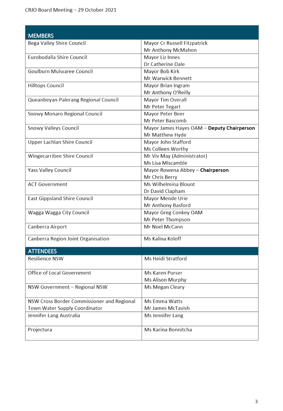

12.2 Minutes of the Country Mayors Association AGM and General Meetings held on 5 November 2021
REPORT
The minutes of the Country Mayors Association Annual General and General meetings held on 5 November 2021 are included in Attachments A and B.
From these minutes there are no items which covers a matter that:
· Requires expenditure not provided for in the current Operational Plan
· Involves a variation to a Council policy
· Is contrary to a previous decision or position of Council
· Relates to a matter which requires Council to form a view or adopt a position
· Deals with a matter of specific interest
Accordingly, the minutes are presented for information.
|
That the minutes of the Country Mayors Association Annual General meeting and General meeting held on 5 November 2021 be noted |
ATTACHMENTS: a. Country Mayors Association Annual General Meeting Minutes 5 November 2021 ⇩
b. Country Mayors Association General Meeting Minutes 5 November 2021 ⇩
12.2 Minutes of the Country Mayors Association AGM and General Meetings held on 5 November 2021
Attachment a Country Mayors Association Annual General Meeting Minutes 5 November 2021
Attachment b Country Mayors Association General Meeting Minutes 5 November 2021

12.3 Minutes of the Traffic Facilities Committee held on 3 November 2021
Report
The minutes of the Traffic Facilities Committee meeting held on 3 November 2021 are included in Attachment A.
From these minutes there are two items which covers a matter that:
· Requires expenditure not provided for in the current Operational Plan
· Involves a variation to a Council policy
· Is contrary to a previous decision or position of Council
· Relates to a matter which requires Council to form a view or adopt a position
· Deals with a matter of specific interest
The Committee have made recommendations in relation to the 2021 Christmas Parade to be held in Yass and the installation of a disabled parking space in Lead Street, Yass.
|
That the minutes of the Traffic Facilities Committee meeting held on 3 November 2021 be noted and the following recommendations be adopted: Item 7.2 Christmas Parade 2021 - Yass That the proposed 2021 Christmas Parade be approved subject to the following conditions: 1. The organiser is to supply Council with a copy of the current Public Liability Insurance for the event with a minimum $20,000,000 indemnity. Transport for NSW, NSW Police and Yass Valley Council are to be identified on the insurance document as ‘interested parties’ or equivalent 2. The event organiser develop and implement a Traffic Management Plan (TMP) and associated Traffic Guidance Scheme (TSG) 3. The event organiser provide Council with a Risk Management Plan for the event. Particularly attention to be given to managing the pedestrian interface with vehicles in the parade 4. The event organiser is responsible for directly notifying all residents that may be affected by the approved events as soon as possible 5. The event organiser is responsible for public notification of the road closure and advising emergency services providers 6. Event marshals, event participants etc. will at all times obey the provisions of NSW Transport Legislation 7. The event organiser is to arrange the supply and installation/removal of appropriate signs etc. identified in the TMP and associated TGS. All personnel involved must be appropriate accredited. 8. The event organiser is to ensure any local traffic, emergency services vehicles etc can safely and efficiently access/egress any property impacted by the TMP and associated TGS 9. Event organisers, event marshals, volunteers, event participants etc. are to take all possible actions to minimise the effect of the event on the non-event community, throughout the event 10. The event organiser must comply with any COVID-19 restrictions current at the time of the event including compliance with Restrictions on Gathering and Movement Public Health Orders, which may require developing and complying with a COVID-19 safety Plan 11. Event organisers shall comply with the above conditions and the undertakings in its submission. Failure to comply will immediately void this approval Item 7.3 Disabled Parking Space – Lead Street, Yass That the installation of a disable car parking space near 73 Lead Street, Yass be supported in principle, provide it complies with Australian Standards, either as parallel parking at the Crago Street end or angle parking the Comur Street end |
ATTACHMENTS: a. Traffic Facilities Committee Minutes 3 November 2021 ⇩