Ordinary Meeting of Council
Wednesday 23 September 2020
4.00pm
Council Chambers
209 Comur Street, Yass
Ordinary Meeting of Council
Wednesday 23 September 2020
4.00pm
Council Chambers
209 Comur Street, Yass
|
PRAYER:
All Stand:
Mayor: Let us be still and remember the presence of God. As we commence our meeting let us together pray for guidance and help.
All say together:
Almighty God, we ask your blessing upon this Council.
Direct and prosper our deliberations to the true welfare of Australia and the people of Yass Valley Amen.
|
FUTURE MEETINGS
|
October 2020
Wednesday 28th 4.00pm Ordinary Meeting of Council
|
Ordinary Meeting of Council
Open Forum Page No.
Webcasting
This meeting is being webcast, a reminder to those in attendance that you should refrain from making any defamatory statements.
Acknowledgement of Country
I acknowledge that we are meeting on the ancestral land of the Ngunnawal people. I recognise the Ngunnawal as the traditional custodians and pay respect to the Elders of the community and their descendants.
1. Prayer
2. Apologies
3. Declaration of Pecuniary Interests/Special Disclosures
4. Confirmation of Minutes
Minutes of Ordinary Council Meeting held on 26 August 2020................................................ 5
5. Election of Mayor and Deputy Mayor
5.1 Election of Mayor and Deputy Mayor................................................................................. 179
5.2 Disclosures by Councillors and Designated Persons Return.................................................. 184
7. Director of Planning & Environment Reports
7.1 Planning Proposal - 7 Iceton Place, Yass............................................................................... 21
7.2 Development Control Resources......................................................................................... 32
7.3 Development Application No DA200069 - Dwelling House, 15 Hanley Place, Yass................... 34
7.4 Development Application No DA200049 - Subdivision, Isabel Drive, Murrumbateman............ 67
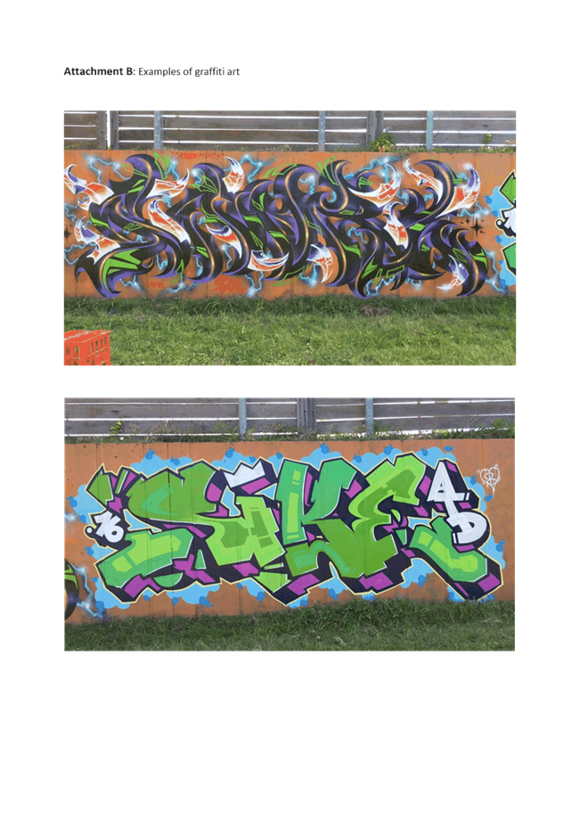
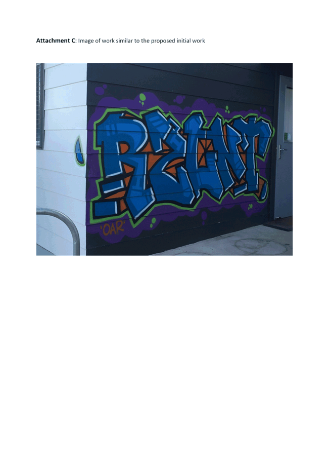
7.5 Graffiti Art Proposal.......................................................................................................... 118
6.6 Development Consent No DA135014D - Residential Subdivision, 14 Wellington Road and 2 Grand Junction Road, Yass........................................................................................................... 123
8. Director of Infrastructure & Assets Reports
8.1 NSW Road Classification and Regional Roads Recommendations......................................... 124
8.2 Shingle Hill Way Bridge Replacement and Road Realignment - Land Acquisition and Road Closure........................................................................................................................................ 129
8.3 Yass Public School - Traffic Concerns.................................................................................. 132
8.4 Road Reserve Weed Spraying Trial..................................................................................... 134
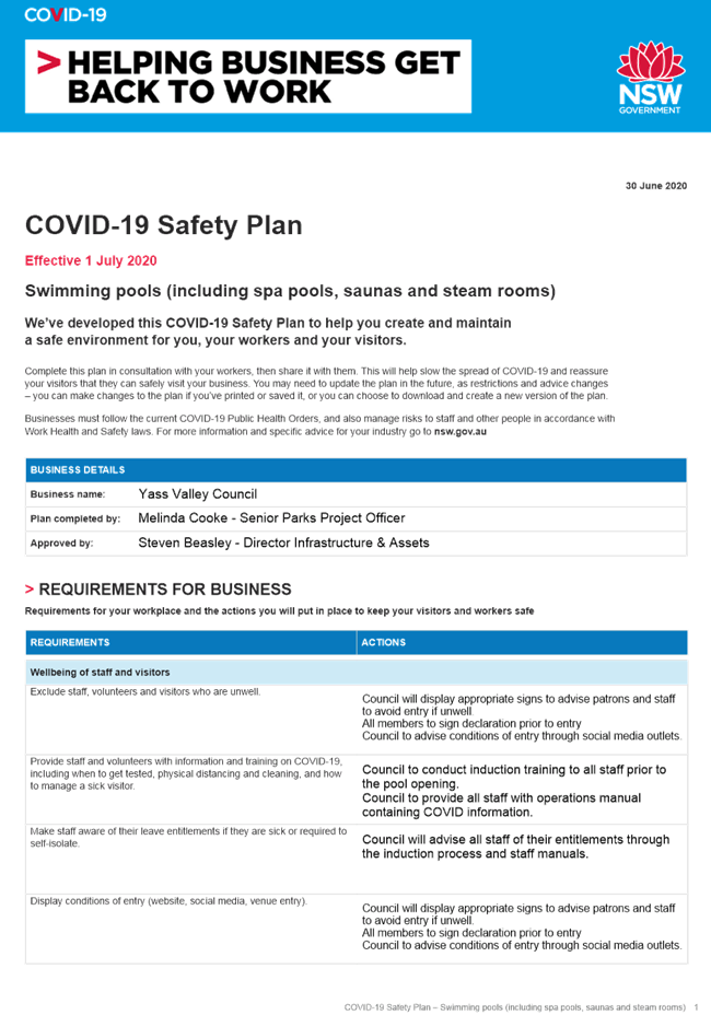
8.5 Yass & Binalong Swimming Pool Covid-19 Response........................................................... 136
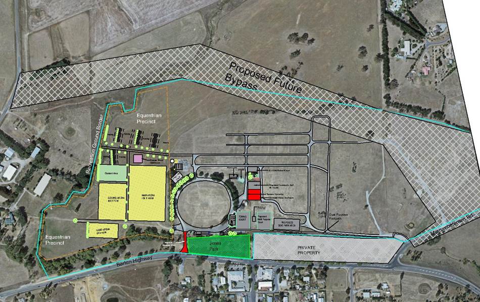
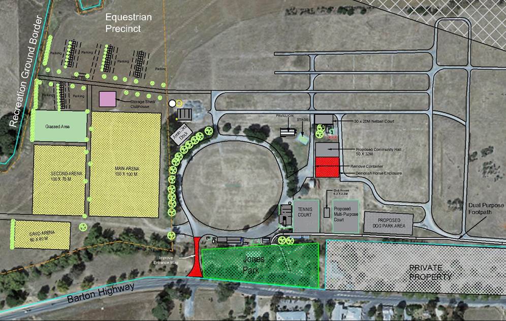
8.6 Draft 2020 Stategic Plan Murrumbateman Recreation Grounds........................................... 163
9. Director of Corporate & Community Reports
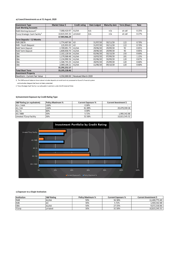
9.1 Investment and Borrowings Report.................................................................................... 175
10.3 Application for Financial Hardship...................................................................................... 187
Nil
Nil
13. Minutes and Recommendations of Council Committees
Nil
Close of Meeting Time
Chris Berry
GENERAL MANAGER
8.1 Investment and Borrowings Report
Attachment a August 2020 - Investments
Minutes of the
Ordinary Meeting of Council
Wednesday 26 August 2020
4.00pm
Council Chambers
209 Comur Street, Yass
Table of Contents
1. Prayer
2. Apologies
3. Declaration of Interest/Disclosures
4. Confirmation of Minutes
5. Mayoral Minute
6. Director of Planning & Environment Reports
6.1 Proposed Biocertification of Council Owned Property "Hawthorn"
6.2 Planning Proposal - Administrative Amendment: 82 Laidlaw Street, Yass
6.3 Planning Proposal - 2155 Sutton Road, Sutton
6.4 Development Application DA200025 - Dragon Dreaming - Caves Road, Wee Jasper
7. Director of Infrastructure & Assets Reports
7.1 NSW Road Classification and Regional Roads Review Overview.. 5
7.2 Safety Concerns Burley Griffin Way, Binalong - Safety Barriers
7.3 Access to Murrumbateman Recreation Area, Barton Highway, Murrumbateman
7.4 Tender Evaluation Report - Yass Valley Way Reconstruction YVC/ASS/03.2020
7.5 Tender Evaluation Report - Cleaning Services for Specified Council Buildings and Amenities YVC/IA/05.2020
7.6 Tender Evaluation Report - Walker Park Grandstand YVC/PG/04.2020
8. Director of Corporate & Community Reports
8.1 Six Monthly Progress Reporting on the 2017/18 - 2020/21 Delivery Program
8.2 Draft 2019/20 Annual Financial Statements
8.3 Revotes from 2019/20 to 2020/21
8.4 Rates and Charges Arrears
8.5 Investment and Borrowings Report
8.6 Amendments to the Model Code of Conduct and Procedures for Local Councils in NSW
9. General Manager Reports
9.1 Design for Civic Precinct Project (Including Library and Work Hub) - 209 Comur Street, Yass
10. Notice of Motion
10.1 Notice of Motion - Affordable Meeting Spaces during COVID-19
10.2 Notice of Motion - Standard Committee Constitution
11. Questions with Notice
12. Minutes and Recommendations of Council Committees
12.1 Minutes of the Audit, Risk & Improvement Committee Meeting held on 14 July 2020
13. Confidential Matters
13.1 Tender Evaluation Report - Yass Valley Way Reconstruction YVC/ASS/03.2020
13.3 Tender Evaluation Report - Walker Park Grandstand YVC/PG/04.2020
13.2 Tender Evaluation Report - Cleaning Services for Specified Council Buildings and Amenities YVC/IA/05.2020
Presentations to Council – Items on the Meeting Agenda
SPEAKERS VIA ZOOM
Item 6.2 Planning Proposal – Administrative Amendment: 82 Laidlaw Street, Yass
Jack Walker
Item 6.4 – Development Application DA200025 – Dragon Dreaming – Caves Road, Wee Jasper
Helen Cathles
Item 9.1 Design for Civic Precinct Project
Bec Duncan
Council Meeting - The Mayor declared the meeting open at 4.18 pm.
Present
Councillors Rowena Abbey, Mayor, in the chair, Cecil Burgess, Geoff Frost, Nathan Furry, Allison Harker (via Zoom), Jasmin Jones, Michael McManus, Mike Reid (via Zoom) and Kim Turner.
Also present were the General Manager – Chris Berry, Director of Planning & Environment – Julie Rogers, Interim Director of Infrastructure & Assets – Steven Beasley, Director of Corporate & Community – Mark Eady and Corporate Planning & Executive Support Officer – Shirree Garland.
Acknowledgement of Country
1. Prayer
2. Apologies
Nil
3. Declaration of Interest/Disclosures
Councillor Jones declared a pecuniary conflict of interest in Item 13.2 – Tender Evaluation Report – Cleaning Services for Specified Council Buildings and Amenities YVAIA/05.2020 and stated that she believed her interest would preclude her from voting.
Reason: Councillor Jones declared an interest as the tender was advertised in the Sydney Morning Herald but not the Yass Valley Times before the resolution of Council to not advertise in Yass Valley Times.
Councillor McManus declared a significant, non-pecuniary conflict of interest in Item 10.1 – Notice of Motion – Affordable Meeting Spaces During COVID-19 and stated that he believed his interest would preclude him from voting.
Reason: Councillor McManus declared an interest as he is the Vice President and Life Member of the Yass Soldiers Club.
4. Confirmation of Minutes
|
RESOLVED that the minutes of the Ordinary Council Meeting held on 22 July 2020 resolution numbers 103-155 inclusive be taken as read and confirmed. (Furry/Turner) 116 |
FOR: Councillors R Abbey, C Burgess, G Frost, N Furry, A Harker, J Jones, M McManus, M Reid and K Turner
AGAINST: Nil
5. Mayoral Minute
6. Director of Planning & Environment Reports
FOR: Councillors R Abbey, C Burgess, G Frost, N Furry, A Harker, J Jones, M McManus, M Reid and K Turner
AGAINST: Nil
FOR: Councillors R Abbey, C Burgess, G Frost, N Furry, A Harker, J Jones, M McManus, M Reid and K Turner
AGAINST: Nil
FOR: Councillors R Abbey, C Burgess, G Frost, N Furry, A Harker, J Jones, M McManus, M Reid and K Turner
AGAINST: Nil
7. Director of Infrastructure & Assets Reports
FOR: Councillors R Abbey, C Burgess, G Frost, N Furry, A Harker, J Jones, M Reid and K Turner
AGAINST: Councillor M McManus
FOR: Councillors R Abbey, C Burgess, G Frost, N Furry, A Harker, J Jones, M McManus, M Reid and K Turner
AGAINST: Nil
FOR: Councillors R Abbey, C Burgess, G Frost, N Furry, A Harker, J Jones, M McManus, M Reid and K Turner
AGAINST: Nil
FOR: Councillors R Abbey, C Burgess, G Frost, N Furry, A Harker, J Jones, M McManus, M Reid and K Turner
AGAINST: Nil
8. Director of Corporate & Community Reports
FOR: Councillors R Abbey, C Burgess, G Frost, N Furry, A Harker, J Jones, M McManus, M Reid and K Turner
AGAINST: Nil
FOR: Councillors R Abbey, C Burgess, G Frost, N Furry, A Harker, J Jones, M McManus, M Reid and K Turner
AGAINST: Nil
FOR: Councillors R Abbey, C Burgess, G Frost, N Furry, A Harker, J Jones, M McManus, M Reid and K Turner
AGAINST: Nil
FOR: Councillors R Abbey, C Burgess, G Frost, N Furry, A Harker, J Jones, M McManus, M Reid and K Turner
AGAINST: Nil
FOR: Councillors R Abbey, C Burgess, G Frost, N Furry, A Harker, J Jones, M McManus, M Reid and K Turner
AGAINST: Nil
FOR: Councillors R Abbey, C Burgess, N Furry, A Harker, J Jones, M McManus, M Reid and K Turner
AGAINST: Councillor G Frost
9. General Manager Reports
NOTE: Original recommendation was not considered.
9.1A Design for Civic Precinct Project (Including Library and Work Hub) - 209 Comur Street, Yass - Suplementary Report
SUMMARY
To present a supplementary report on the draft project brief for the preparation of plans and documentation for the design of an civic precinct project (including library and work hub) at 209 Comur Street, Yass.
|
1. Council commence an immediate cross media strategy to publicise to the Yass Valley public its intention to begin work on a civic precinct project. The strategy to highlight: a. The favoured location – 209 Comur Street, Yass b. The scope of the intended works to include but not limited to a new library, community meeting rooms, small business centre/work hub, short term accommodation, space for long term government tenants 2. Feedback from the public be received by submissions through a range of suitable mechanisms including a forum 3. A procurement process be undertaken to engage a suitably qualified and experienced consultant for the project (Jones/Turner) 133 |
|
FOR: Councillors R Abbey, C Burgess, G Frost, N Furry, A Harker, J Jones, M McManus, M Reid and K Turner AGAINST: Nil |
10. Notice of Motion
FOR: Councillors G Frost, J Jones and K Turner
AGAINST: Councillors R Abbey, C Burgess, N Furry, A Harker and M Reid
MOTION LOST
At 06:29 pm Councillor McManus returned to the Chambers
FOR: Councillors R Abbey, C Burgess, G Frost, N Furry, A Harker, J Jones, M McManus, M Reid and K Turner
AGAINST: Nil
11. Questions with Notice
Nil
12. Minutes and Recommendations of Council Committees
FOR: Councillors R Abbey, C Burgess, G Frost, N Furry, A Harker, J Jones, M McManus, M Reid and K Turner
AGAINST: Nil
13. Confidential Matters
FOR: Councillors R Abbey, C Burgess, G Frost, N Furry, A Harker, J Jones, M McManus, M Reid and K Turner
AGAINST: Nil
Closed Council commenced at 6.39 pm.
|
13.1 Tender Evaluation Report - Yass Valley Way Reconstruction YVC/ASS/03.2020
|
|
SUMMARY This report provides advice on the submission of tenders for the Yass Valley Way Reconstruction, contract YVC/ASS/03.2020. This tender includes the reconstruction of 5.26km of Yass Valley Way commencing from the double roundabouts near the Barton Highway through to the intersection of the Hume Highway. |
|
1. The tender of $1,125,465.62 from Roadworx Surfacing to reconstruct the 5.26km of failing pavement on Yass Valley Way be accepted. 2. A contingency of $200,000 be allocated for latent conditions and unsuitable material. (Furry/Burgess) 138 |
FOR: Councillors R Abbey, C Burgess, G Frost, N Furry, A Harker, J Jones, M McManus, M Reid and K Turner
AGAINST: Nil
|
13.3 Tender Evaluation Report - Walker Park Grandstand YVC/PG/04.2020
|
|
SUMMARY This report provides advice on the submission of tenders for the construction of a covered grandstand, commentator’s box, footpath and disabled amenities at Walker Park Sporting Complex, Yass. |
|
RESOLVED that the lump sum tender of $571,454.03 (ex GST) be accepted from Monarch Building Solutions for the construction of a covered grandstand, commentator’s box, footpath and disabled amenities at the Walker Park Sporting Complex, Yass. (McManus/Turner) 139 |
FOR: Councillors R Abbey, C Burgess, G Frost, N Furry, A Harker, J Jones, M McManus, M Reid and K Turner
AGAINST: Nil
At 06:51 pm Councillor Jones left the Chambers.
Councillor Reid left the meeting at 6.55pm
FOR: Councillors R Abbey, C Burgess, G Frost, N Furry, A Harker, M McManus and K Turner
AGAINST: Nil
|
RESOLVED that the meeting move into Open Council. (Turner/Furry) 141 |
FOR: Councillors R Abbey, C Burgess, G Frost, N Furry, A Harker, M McManus, and K Turner
AGAINST: Nil
Open Council resumed at 7.00 pm.
|
RESOLVED that the recommendations in Closed Council be adopted. (Furry/Turner) 142 |
FOR: Councillors R Abbey, C Burgess, G Frost, N Furry, A Harker, M McManus, and K Turner
AGAINST: Nil
The
meeting closed at 7.01 pm.
![]()
Rowena Abbey
Mayor
5.1 Election of Mayor and Deputy Mayor
SUMMARY
To provide the framework for the election of the Mayor and Deputy Mayor.
|
That: 1. The General Manager be the Returning Officer for the Mayor and Deputy Mayor elections. 2. Following the close of nominations for the position of Mayor the method of electing the Mayor be determined from one of the following options in accordance with Schedule 7 Local Government (General) Regulation 2005 if there is more than one nomination: a. Open Voting b. Ordinary Ballot c. Preferential Ballot 3. Following the close of nominations for the position of Deputy Mayor the method of electing the Mayor be determined from one of the following options in accordance with Schedule 7 Local Government (General) Regulation 2005 if there is more than one nomination: a. Open Voting b. Ordinary Ballot c. Preferential Ballot
|
Financial IMPLICATIONS
Nil
POlicy & Legislation
Conducting the election in accordance with Schedule 7 Local Government (General) Regulation 2005 and the Local Government Amendment (Governance and Planning) Act 2016 will meet Council’s governance obligations.
REPORT
1. Background
In accordance with s225 Local Government Act 1993, Council is required to elect a Mayor. Under s230(1) of the Act a Mayor elected by Councillors holds office for two years. Councillors may also choose to elect a fellow Councillor as Deputy Mayor.
The two year term of the current Mayor and Deputy Mayor was due to be concluded in September 2020. However due to the COVID-19 pandemic the State Government have deferred the Local Government elections until 4 September 2021 (refer Attachment A). Council are therefore required to elect a Mayor and Deputy Mayor for a one year term until September 2021.
The Local Government Act 1993 provides for the General Manager or the person appointed by the General Manager to be the Returning Officer. The election of the Mayor is to be carried out in accordance with Clause 394 Local Government (General) Regulation 2005. i.e.
Local Government (General) Regulation 2005
Cl 394 Election of mayors by councillors
If a mayor or deputy mayor is to be elected by the councillors of an area, the election is to be in accordance with Schedule 7.
Schedule 7 – Election of mayor by councillors (Clause 394)
Part 1 Preliminary
1 Returning officer
The general manager (or a person appointed by the general manager) is the returning officer.
2 Nomination
(1) A councillor may be nominated without notice for election as mayor or deputy mayor.
(2) The nomination is to be made in writing by 2 or more councillors (one of whom may be the nominee). The nomination is not valid unless the nominee has indicated consent to the nomination in writing.
(3) The nomination is to be delivered or sent to the returning officer.
(4) The returning officer is to announce the names of the nominees at the council meeting at which the election is to be held.
3 Election
(1) If only one councillor is nominated, that councillor is elected.
(2) If more than one councillor is nominated, the council is to resolve whether the election is to proceed by preferential ballot, by ordinary ballot or by open voting.
(3) The election is to be held at the council meeting at which the council resolves on the method of voting.
(4) In this clause:
“ballot” has its normal meaning of secret ballot.
“open voting” means voting by a show of hands or similar means.
2. Election of Mayor
Nomination papers for the election of Mayor and Deputy Mayor for the 2020/21 term have been circulated to Councillors
Nominations for the position of Mayor shall be in writing by two or more Councillors (one of whom may be the nominee). The nomination must have the consent of the nominee in writing.
The nomination is to be delivered or sent to the Returning Officer who will announce the names of nominees at the meeting.
If only one candidate is nominated, that Councillor is elected.
When more than one candidate is nominated, the Council may, by resolution, decide whether the election shall be carried out by:
a. Open voting – procedure identical to Ordinary Ballot, however, the voting is by show of hands or similar means, not a Ballot Paper.
b. Ordinary ballot – involving the marking of Ballot Papers – subsequent exclusion of one candidate; further voting and exclusions; repeated until two candidates only remain, final vote between remaining two candidates.
c. Preferential ballot – the complete numbering of Ballot Papers in consecutive order of preference for all candidates, commencing with “1” as first preference.
Both preferential and ordinary ballots are secret. Under the ordinary ballot system the Councillors vote ‘”1” for the candidate of their choice and if there are three or more, the lowest is excluded at each ballot until only two remain and the person with the most votes at that ballot is declared elected. This system is less complicated than preferential voting and ensures that the direct vote of Councillors (not preferences) will determine who is elected as Mayor. Previously, this Council has always adopted the ordinary ballot system for Mayoral elections and this has been proposed in the recommendation.
3. Election of Deputy Mayor
Section 231 of the Act provides that Council may elect a Deputy Mayor for the Mayoral term, or a shorter period if specified. This Council has always elected to have a position of Deputy Mayor and filled that position for the same period as the Mayor. A nomination form for this position is attached.
4. Mayoral Allowance
After consideration of the findings of the Local Government Remuneration Annual Determination, Council, at its meeting of 22 July 2020 set, the Mayoral Allowance at $26,530. Council in the past has paid part of the Mayoral allowance to the Deputy Mayor in accordance with Council’s Councillor Expenses and Provision of Facilities Policy. Council set the Deputy Mayoral Allowance (to be paid from the Mayoral Allowance) at $1,500 per annum.
Theme 7. Council Governance and Finance
Long Term Goal 7.1 - Our council acts responsibly in its civic leadership role and is effective in planning and managing local growth and change
Strategy 7.1.3 – Consider social, environmental and economic sustainability in all Council planning, decision making and actions.
Strategic Action 7.1.3.1 – Develop a framework for long term planning and decision making which balances social, environmental and economic factors.
Attachments: a. OLG Circular 20-29 4 August 2020 ⇩
5.2 Disclosures by Councillors and Designated Persons Return
To comply with s440AAB Local Government Act1993 a register and tabling of returns must be maintained.
RECOMMENDATIONThe Register of Disclosures by Councillors and Designated Persons Return 2019-2020, as table, be noted |
Nil.
The tabling of these returns is a statutory obligation under the Local Government Act 1993.
Section 440 Local Government Act 1993, prescribe that Council have a Model Code of Conduct (the Code). Under this section and as part of Council’s Model Code of Conduct Councillors and designated person are required to complete and lodge with the General Manager, a Disclosure by Councillors and Designated Persons Return within three months after becoming a Councillor of designated person. Designated persons are those that have been identified as having significant contact with the general public.
Annual Returns are then due to be lodged each year prior to 30 September.
Part 4 Pecuniary Interests, s4.21 of the Model Code of Conduct states:
4.21 A councillor or designated person must make and lodge with the general manager a return disclosing the councillor’s or designated person’s interests as specified within 3 months after:
(a) becoming a councillor or designated person, and
(b) 30 June of each year, and
(c) the councillor or designated person becoming aware of an interest they are required to disclose under schedule 1 that has not been previously disclosed in a return lodged under paragraphs (a) or (b).
Section 4.8 of the Code identifies that the General Manager and other senior staff of Council are designated persons. Council may also identify a member of staff or a delegate or members of a Council committee to be considered a designated person.
Positions have been identified which are thought to fit within this definition. The occupants of those positions are considered designated persons in accordance with Section 4.8 of the Code. The table below lists the Councillors and the positions identified as designated persons.
The returns are considered open access information in accordance with the Government Information (Public Access) Act 2009. The returns are placed on a Register of Returns which is available for inspection and is tabled at the Council meeting in accordance with the requirements of 4.26 of the Code.
|
Position |
Directorate |
|
Councillor |
Council |
|
Councillor |
Council |
|
Councillor |
Council |
|
Councillor |
Council |
|
Councillor |
Council |
|
Councillor |
Council |
|
Councillor |
Council |
|
Councillor |
Council |
|
Councillor |
Council |
|
General Manager |
Executive |
|
Manager Risk, Audit & Improvement |
Executive |
|
Director |
Planning & Environment |
|
Manager Development Control |
Planning & Environment |
|
Manager Strategic Planning |
Planning & Environment |
|
Coordinator Environmental Services |
Planning & Environment |
|
Senior Environmental Health Officer |
Planning & Environment |
|
Environmental Health Officer |
Planning & Environment |
|
Assistant Environmental Health Officer |
Planning & Environment |
|
Compliance Ranger |
Planning & Environment |
|
Senior Biosecurity Weeds Officer |
Planning & Environment |
|
Natural Resource & Sustainability Officer |
Planning & Environment |
|
Development Planner |
Planning & Environment |
|
Development Planner |
Planning & Environment |
|
Development Planner |
Planning & Environment |
|
Development Planner |
Planning & Environment |
|
Building Surveyor |
Planning & Environment |
|
Building Surveyor |
Planning & Environment |
|
Director |
Corporate & Community |
|
Chief Financial Officer |
Corporate & Community |
|
Manager Organisation Development |
Corporate & Community |
|
Manager ICT |
Corporate & Community |
|
Manager Tourism & Business Liaison |
Corporate & Community |
|
Coordinator Library Services |
Corporate & Community |
|
Financial Accountant |
Corporate & Community |
|
Director |
Infrastructure & Assets |
|
Manager Maintenance Services |
Infrastructure & Assets |
|
Manager Water & Wastewater |
Infrastructure & Assets |
|
Manager Engineering Services |
Infrastructure & Assets |
|
Manager Roads Delivery |
Infrastructure & Assets |
|
Manager Facility & Waste Assets |
Infrastructure & Assets |
|
Manager Recreational Assets |
Infrastructure & Assets |
|
Project Engineer Water & Wastewater |
Infrastructure & Assets |
|
Asset Engineer |
Infrastructure & Assets |
|
Support Engineer |
Infrastructure & Assets |
|
Parks Project Officer |
Infrastructure & Assets |
|
Coordinator Fleet & Procurement |
Infrastructure & Assets |
Key Pillar 5. Our Civic Leadership
CSP Strategy CL1 - Effect resourceful and respectful leadership and attentive representation of the community
Delivery Program Action CL1.4 - Be compliant, more efficient and effective
Operational Plan Activity CL1.4.2 - All regulated compliance is adhered to
Ordinary Council Meeting 23 September 2020
7.1 Planning Proposal - 7 Iceton Place, Yass
SUMMARY
To present a report on a draft Planning Proposal seeking an amendment to the minimum lot size under the Yass Valley LEP 2013 for 7 Iceton Place, Yass.
|
That: 1. Draft Planning Proposal - 7 Iceton Place, Yass (PP.2020.03) be endorsed and forwarded to the Minister for Planning and Public Spaces to request a Gateway determination pursuant to s3.34 Environmental Planning & Assessment Act 1979 2. Planning Proposal (PP.2020.03) be adopted if no significant objections are received after the public exhibition of the Planning Proposal pursuant to the conditions of Gateway determination in accordance with s3.34(2)(c) Environmental Planning & Assessment Act 1979 |
Financial IMPLICATIONS
Nil.
POlicy & Legislation
· Environmental Planning & Assessment Act 1979
· Yass Valley Local Environmental Plan 2013
· Yass Valley Settlement Strategy 2036
REPORT
1. Introduction
The Yass Valley Settlement Strategy 2036 was adopted in August 2017. The Strategy sets a direction and a framework for the consideration of future development within the Yass Valley particularly Yass and Murrumbateman. It is estimated that the population of Yass and District will be 10,645 people by 2036, with an ultimate population of 20,000 people. Yass needs an additional 5,360 residential lots to accommodate the additional population growth by 2036. Land which is currently zoned residential has a capacity of 2,645 residential lots requiring more land to be rezoned to meet the shortfall of 2,715 residential lots.
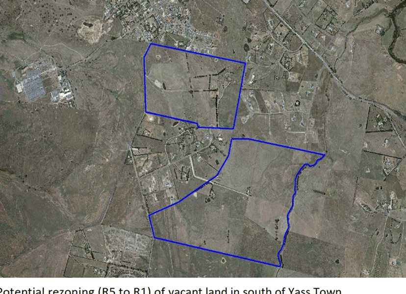
The Strategy identified greenfield and brownfield sites in Yass to accommodate future population growth. The land immediately south of Cusack Place/Craig Close is also identified as Potential Future Residential Expansion Area (refer Attachment A).
2. Planning Proposal
A draft Planning Proposal has been received seeking an amendment to the minimum lot sizes in the Yass Valley LEP 2013 for the land at 7 Iceton Place, Yass.
The site is located approximately 3km from the Yass town centre and is situated immediately south of the Yass Valley Way and Craig Close, east of Cusack Place and Gums Lane and west of Dog Trap Road. O’Brien’s Creek flows through the site in a northerly direction toward the Yass River (refer Figure 1 below).
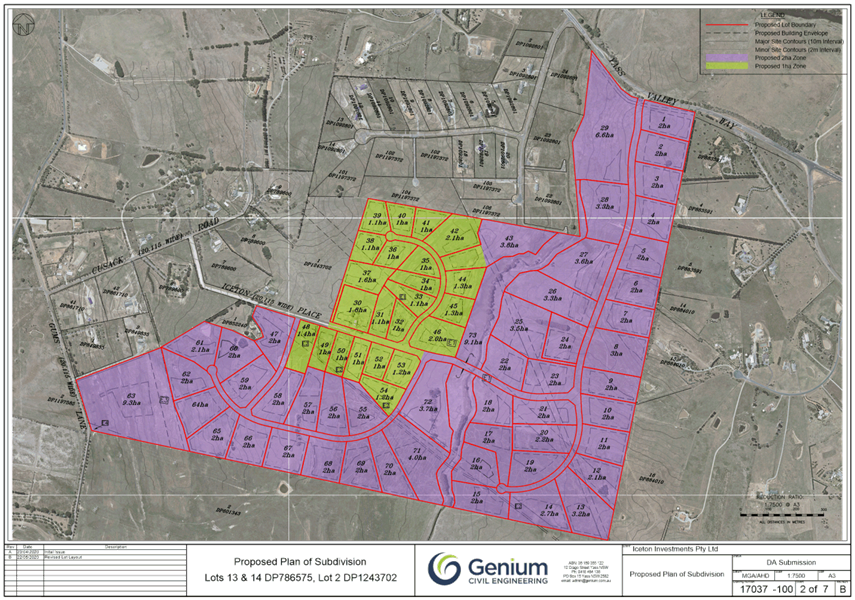
The site is comprised of three parcels of land and has a total area of 173.3ha. The site is currently zoned R5 Large Lot Residential with a minimum lot size of 10ha under Yass Valley LEP 2013.
Surrounding development is characterised as rural residential comprising detached houses.
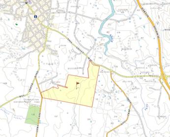
Figure 1: Site Location
The draft Planning Proposal seeks to amend the Yass Valley LEP 2013 by reducing the minimum lot size of the site from 10ha to 1ha and 2ha. It is proposed that the majority of the site (141.8ha) will have a minimum lot size of 2ha whereas a smaller section (31.5ha) will have 1ha minimum lot size (refer Attachment B).
The draft Planning Proposal would enable the eventual development of the site for approximately 72 rural residential lots.
2.1 Site Analysis
Ecological Value
The submitted Biodiversity Development Assessment Report (BDAR) has identified the biodiversity values and constraints to development.
The assessment indicates that the site is extensively cleared and has been subject to pasture improvement over many years. The ecological surveys found that 82% of the site does not support any significant biodiversity values. The vegetation in the riparian zone along O’Briens Creek is largely characterised by exotic pasture grasses and the only woody riparian vegetation is restricted to a few small patches of Willow and Elm.
Only 18% of the site supports significant biodiversity values. There are patches of habitat of two threatened species – Golden Sun Moth and Striped Legless Lizard (refer Attachment C).
A conceptual lot layout has been prepared where the main patches of Golden Sun Moth and Striped Legless Lizard habitats are contained in larger lots. Similarly, a separate lot has been created to protect riparian land. These lots can be managed through Conservation Agreements or similar mechanism, to protect and manage the 19.22ha of land that supports significant biodiversity values.
The areas of habitat that would be impacted by the proposed development will be required to be offset. The offsets would be calculated at the development assessment stage if the amendment to Yass Valley LEP 2013 is approved.
Traffic Impact Assessment
The submitted Traffic Impact Assessment Report notes that the proposed development is expected to generate a total of 533 additional daily vehicle movements, of which 409 are expected to exit and enter the site through Yass Valley Way.
The secondary access will be provided to Wee Jasper Road via Iceton Place, Cusack Place and Gums Lane which currently carry relatively low volumes of traffic.
The report recommends works to mitigate traffic impacts. The proposed development is not anticipated to create of any significant traffic impacts with the implementation of the recommended mitigation measures.
Heritage
The site is not listed at a Heritage Item in the Yass Valley LEP 2013.
An Aboriginal Cultural Heritage Assessment concludes that:
· No registered Aboriginal heritage sites are located within the site
· No areas of potential archaeological deposits or heritage sites have been identified within the site and the potential for Aboriginal heritage objects to be present within has been assessed as low
· A subdivision of the site for rural residential purposes can proceed without further investigation or heritage assessment
Contaminated Land
Four potential areas of environmental concern from imported fill, the use of agricultural chemicals, fuel storage, and zinc leaching from galvanized corrugated roof sheeting from sheds on site has been identified in the Stage 1 Preliminary Site Investigation.
The preliminary investigation concludes that the site could be remediated for residential development, subject to subsurface investigations carried out at Stage 2 Detailed Contamination Investigation as part of the development assessment stage in the planning process.
The report concludes that the Planning Proposal can proceed without further investigation at this time.
Flood Prone Land
Although the site is outside the scope of the Yass Flood Study 2016, O’Briens Creek runs through the site flowing northerly toward the Yass River. A site specific flood impact assessment considered the 1% AEP flood level as the flood planning level and identifies the depth and flood level for the site (refer Attachment D).
Based on this study, the proposal will not be significantly impacted by flooding.
Groundwater Vulnerability
The Yass Valley LEP 2013 identified the southern part of the site is vulnerable to groundwater contamination (refer Figure 2 below).
Future development will need to be assessed to ensure it would not have any impact on the groundwater quality. This can be undertaken as part of any future Development Application should the rezoning be approved.
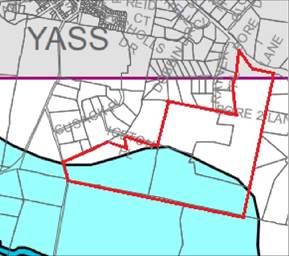
Figure 2: Groundwater Vulnerability
Dryland Salinity
The site is also identified in the Yass Valley LEP 2013 as being partially affected by potential dryland salinity (refer Figure 3 below).
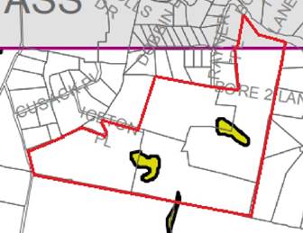
Figure 3: Dryland Salinity
The Land Capability Assessment prepared for the site states that:
· The areas mapped as salt affected are associated with drainage depressions and there is no evidence of saline scalding, no impact to pasture growth or species composition in adjacent paddocks, and no salt crusting evident; and
· These areas are stable and not eroding but do present a limitation to effluent disposal and dwelling construction. These areas are already included in the buffer areas associated with the drainage depressions
Land Capability Assessment
The site is not connected to a reticulated water supply or a reticulated sewerage system. Therefore, any rural residential development on the site will have to secure and manage a sustainable source of water for potable and non-potable uses and on site effluent management systems.
A Land Capability Assessment has been carried out to determine the suitability of the site:
· To sustainably manage on-site effluent on-site as per Australian Standards; and
· Provide unconstrained building sites for the construction of future dwellings
The constraints identified have been reflected on the Land Capability Constraints Plan (refer Attachment E).
Bush Fire Prone Land
The site is not identified on current Bush Fire Prone Land Map. However, it is subject to bushfire risk from grasslands as identified in the Bush Fire Strategic Study prepared for the site.
This report supports the proposed minimum lot size (1-2ha) on the site and concludes that the site is deemed to meet the objectives of the Planning for Bushfire Protection and is capable of meeting the acceptable solutions for Residential and Rural Residential Subdivisions.
3. Strategic Planning Assessment
The proposed amendment is consistent with the recommendation of the South East and Tablelands Regional Plan 2036 and the Yass Valley Settlement Strategy 2036.
The draft Planning Proposal is consistent with the following directions set in the Regional Plan:
· Direction 15: Enhance Biodiversity Connections
The proposal has proposed measures to protect and manage threatened species – the Golden Sun Moth and Striped Legless Lizard as well as the riparian land within the site. This will not only protect the biodiversity values of the site but will also enhance biodiversity connectivity with the surrounding land.
· Direction 24: Deliver Greater Housing Supply and Choice
The proposal will create opportunity for approximately 72 rural residential lots in Yass that will support future housing demand. This will also offer more housing choice and a rural lifestyle in proximity to Yass town.
· Direction 25: Focus Housing Growth in Locations that Maximise Infrastructure and Services
The proposal would create an opportunity for housing in proximity to Yass town with existing infrastructure, services and community facilities.
· Direction 28: Manage Rural Lifestyle
The proposal is also consistent with the Yass Valley Settlement Strategy as the site was identified as a Potential Future Residential Expansion Area in the Strategy with a potential to be zoned R1 General Residential from R5 Large Lot Residential to accommodate the future population growth.
The detailed investigation identified that the site has significant constraints and is not suitable for urban residential development, although it is suitable for rural residential development on larger lots. To that end, the proposal is consistent with the principles of the Strategy that any future development in the Yass Valley should be contiguous to the existing settlements and should utilise existing infrastructure, services and facilities.
The Yass Valley Settlement Strategy identified part of the site as a potential future urban release area. At a Councillor Workshop on the proposal and the form of development was discussed and it was considered that a rural residential use of the area would be more consistent with the pattern of surrounding development taking into account the site’s isolation from water and sewer infrastructure and existing urban development.
4. Conclusion
The proposal is consistent with regional and local strategic planning for future growth and the proposal is considered to have sufficient merit to progress through the Gateway process to allow further consideration.
It is recommended that the draft Planning Proposal be endorsed and forwarded to the Minister for Planning and Public Spaces to request a Gateway determination. Delegation to make the amendment as the local plan-making authority should also be sought.
Key Pillar 1. Our Environment
CSP Strategy EN4 - Maintain a balance between growth, development and environmental protection through sensible planning
Delivery Program Action EN4.1 - Ensure Council's statutory planning instruments are up to date and reflective of the community needs
Operational Plan Activity EN4.1.1 – Undertake ongoing strategic land use planning and reviews of existing instruments
ATTACHMENTS: a. Land identified for future development in south of Yass ⇩
b. Proposed Minimum Lot Sizes ⇩
c. Ecology Map ⇩
d. Flood Map ⇩
e. Land Capability Constraints Map ⇩
6.1 Planning Proposal - 7 Iceton Place, Yass
Attachment a Land identified for future development in south of Yass
Ordinary Council Meeting 23 September 2020
7.2 Development Control Resources
SUMMARY
To request consideration of additional funding for staff resources for this financial year for Development Control within the Planning and Environment Directorate.
|
That: 1. An allocation of $104,000 be made in the 2020/21 budget for the provision of staff resources within the Planning and Environment Directorate for Development Control 2. The allocation of $104,000 be included in the September 2020 quarterly budget review
|
Financial IMPLICATIONS
· Cost of one additional Development Planner until 30 June 2020 is $45,000
· Cost of a Building Certifier two days per week until 31 December 2020 to undertake certification activities is (at the upper end) $59,000
· An additional allocation of $104,000 is required in the 2020/21 budget and would be included in the September 2020 quarterly budget review
POlicy & Legislation
· Operational Plan 2020/21
REPORT
1. Background
Sitting within the Planning and Environment Directorate, Development Control is responsible for the provision of regulatory services such as development assessment and building certification. Functions include (with relevant (approximate) activity numbers for the 2019/20 financial year):
|
Activity |
2019/20 total |
2020/21 to date |
|
Development Applications (including modifications) |
312 |
79 |
|
Complying Development Certificates |
25 |
10 |
|
Construction Certificates |
105 |
12 |
|
Local Activity Applications |
125 |
25 |
|
Subdivision Certificates |
64 |
11 |
|
Occupation Certificates |
118 |
12 |
|
Critical Stage Inspections |
807 |
158 |
|
Swimming Pool Compliance Certificates |
29 |
7 |
|
Planning Certificates |
540 |
101 |
|
Building Information Certificates |
40 |
8 |
Currently, Development Control full time equivalents (FTEs) is as follows:
· Manager – 1 FTE
· Development Planners - 3 FTEs. One FTE position will be a 0.8 FTE position from late October decreasing the FTEs to 2.8
· Building surveyors - 3 FTEs
· Customer Service Officer - 3 FTEs
2. Public Spaces Legacy Program
Council was invited to participate in the Public Spaces Legacy Program and has since lodged an application to be included in the program. If accepted, Council is eligible for $2 million in funding for public space projects if it achieves efficiency targets in development assessment.
In the application the following targets have been proposed:
· 10% reduction in gross median assessment times for development applications from 1 September to 31 December 2020 (58 days)
· 15% reduction in gross median assessment times for Development Applications from 1 January 30 June 2021 (55 days)
· 50% of all new applications lodged through the NSW Planning Portal between 1 September and 31 December 2020 targeting applicants who regularly lodge applications with Council
· Transition 100% uptake of the NSW Planning Portal by 1 July 2021
· Process improvements based on best practice
3. Additional Resources
It is proposed to engage one additional Development Planner and a Building Surveyor via either contract or on a casual basis (two days per week) until 31 December 2020. The additional resources would allow for a focus to be placed on development assessment, continuous improvement and transition to the NSW Planning Portal to meet the targets of the Public Spaces Legacy Program and to complete assessment of the current development applications and associated building certification activities. In addition to this, Council will be undertaking an improvement project relating to Planning Certificates.
Key Pillar 1. Our Environment
CSP Strategy EN4 - Maintain a balance between growth, development and environmental protection through sensible planning
Delivery Program Action EN4.2 - Ensure development application assessment is thorough and efficient
Operational Plan Activity EN4.2.1 - Implement the development process and implement changes aligning with the NSW Government's best practice guidelines
Ordinary Council Meeting 23 September 2020
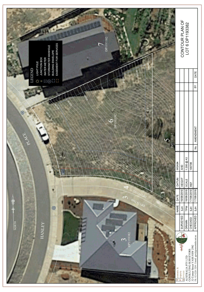
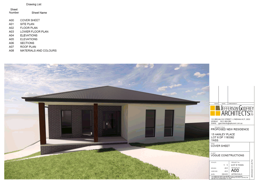
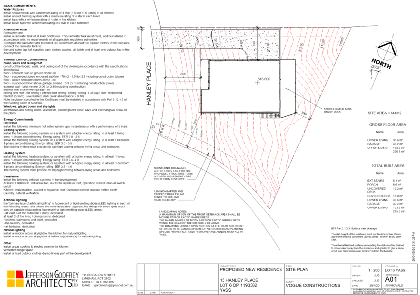
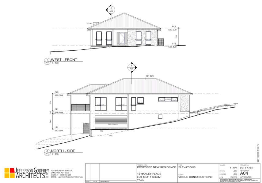
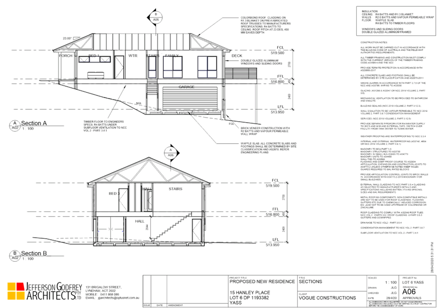
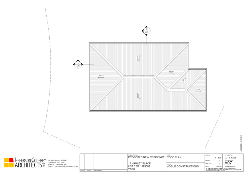
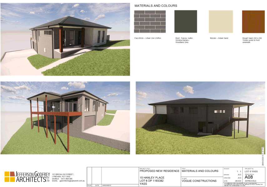
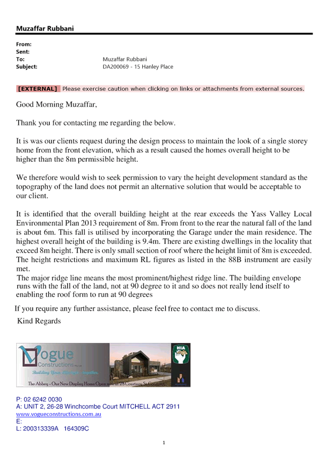
7.3 Development Application No DA200069 - Dwelling House, 15 Hanley Place, Yass
SUMMARY
To consider Development Application DA200069 for a split level two-storey dwelling house at 15 Hanley Place, Yass.
The proposal involves variation to the maximum building height development standard from 8m to 9.4m and a variation to an 88B restriction in relation to direction of the major ridge line of the building is to be at 90 degrees to the general fall of the land.
|
That a Conditional Development Consent be issued for Development Application DA200069 for a split level two-storey dwelling house at 15 Hanley Place, Yass
|
FINANCIAL IMPLICATIONS
Resources for development assessment are provided for in the current Operational Plan.
POLICY & LEGISLATION
· Environmental Planning & Assessment Act 1979
· Environmental Planning & Assessment Regulation 2000
· Biodiversity Conservation Act 2016
· Yass Valley Local Environmental Plan 2013
· Yass Valley Community Engagement Strategy
· Yass Valley Development Contributions Plan 2018
· Road Standards Policy
REPORT
1. Application Details
|
Date Received |
- |
15 May 2020 |
|
Land |
- |
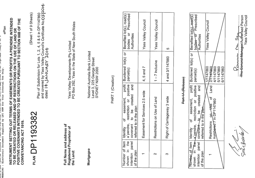
Lot 6 DP 1193382, 15 Hanley Place, Yass |
|
Area |
- |
844m2 |
|
Zoning |
- |
R1 General Residential |
2. Site Description and Locality
The site is located on the eastern side of Hanley Place, Yass. The site is in an elevated position with views to the east over the township and the Yass River. The site is currently vacant and has a significant site fall of about 20.7%. The area can be characterised as residential area comprising detached houses.
A Locality Plan is included in Attachment A.
3. Proposal
The submitted application if for the construction of a split level two-storey dwelling house with covered and uncovered deck, attached garage and installation of a 5,000L water tank. Details of the proposed development are included in Attachment B.
4. Public Exhibition
Public exhibition included notice to seven adjoining and nearby owners and no submissions were received.
5. Assessment
An assessment of the proposal has been completed in accordance with the planning legislation. The proposal generally complies with the relevant planning controls, policies and guidelines with the exception of the maximum building height development standard within the Yass Valley LEP 2013 and restrictions within the section 88B instrument.
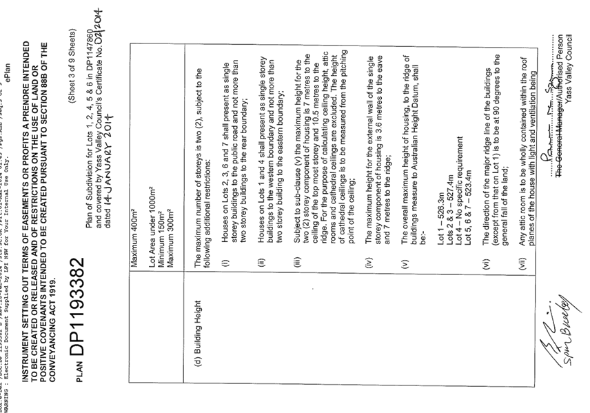
5.1 Building Height
The maximum building height prescribed in the LEP is 8.0m. The maximum height of the proposed dwelling is 9.4m from the ground floor level to the top of the ridge line.
The Applicant has requested (refer Attachment C) a variation on the basis that:
· The proposal complies with the height restriction in the section 88B instrument (in place prior to the LEP height restriction)
· The significant slope of the land
· Only a small proportion of the building exceeds the maximum height
· The dwelling presents as single storey from the street
· The objectives of development standard are achieved despite non-compliance.
An assessment against the guidelines for varying a development standard has been completed and is summarised as follows:
· The height control aims to ensure consistency with the streetscape and to minimise the loss of solar access and privacy for neighbouring development. The height of the proposed dwelling is consistent with the height of other buildings in the locality. The proposed building is single storey at the street frontage but is two storey at the rear of the site and is appropriate in scale
· The proposed dwelling is consistent with the character and streetscape given the environmental characteristics
· Given the environmental constraint of a 20.68% (approximate) site fall from the street (a fall of about 7.75m), the compliance with the development standard is considered unreasonable
· The adjoining lots to the east (13A and 13B Hanley Place) are currently vacant. It is not considered that the proposed dwelling will significantly impact upon these lots by way of overshadowing. This is due to steep slope of land, the variable height of the proposed dwelling, the wider building envelopes on 13A and 13B Hanley Place and 13A and 13B Hanley Place being on the eastern side of the subject land
· There are other dwellings approved in Hanley Place that are greater than 8m in height. On this basis, it is considered that a precedent is already set on building height in this locality
· The proposed development complies with the height restrictions of 10.5m and overall maximum height of the dwelling to the ridge of the building measure to Australian Height Datum of 523.4m in the section 88B Instrument
In this particular instance compliance with the development standard is considered to be unnecessary as the proposal meets the objectives of the height control measure albeit in an alternative way and there are sufficient planning grounds to support the variation. The proposed dwelling is consistent with the zone objectives and it is not inconsistent with the public interest.
5.2 Title Restrictions
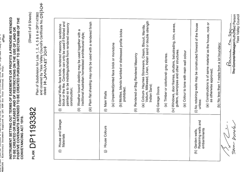
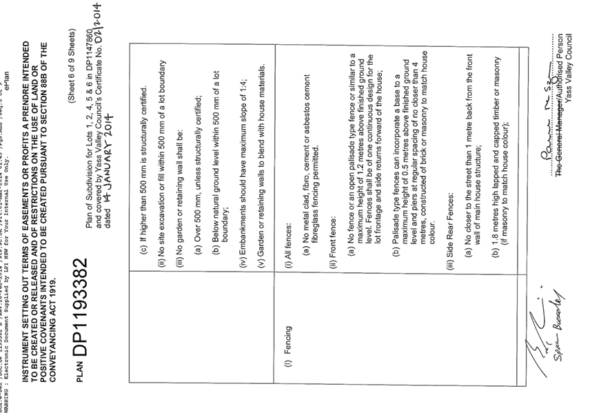
The applicant has sought a number of minor variations to the title restrictions (refer Attachment D) i.e.
a. Direction of the Major Roofline
The title restriction requires the direction of the major ridge line to be at 90 degrees to the general fall of the land. The proposed dwelling has hipped roof with multiple ridgelines. The ridgelines do not comply with the restriction.
The proposed roof design compatible with the existing built form in Hanley Place. The shape of the building envelope runs with the fall of the land and not at 90 degree to it. As such, it does not enable the building/roof form to run at 90 degrees to the fall of the land. In this instance it is considered appropriate that a variation to this restriction is supported.
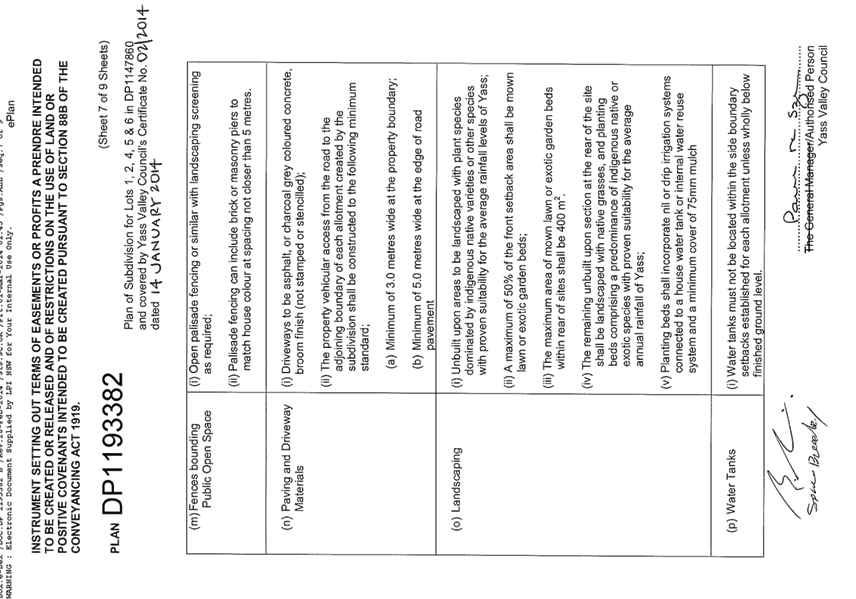
b. Paving and Driveway Materials
The title restriction requires driveway is to be asphalt or charcoal grey coloured concrete. The proposed driveway material is concrete rather than asphalt or charcoal grey coloured concrete. The Applicant is required to have charcoal grey coloured concrete in order to be in keeping with the existing streetscape.
6. Conclusion
From the assessment of the proposal it is recommended that Consent be issued. Draft conditions are included in Attachment E.
Key Pillar 1. Our Environment
CSP Strategy EN4 - Maintain a balance between growth, development and environmental protection through sensible planning
Delivery Program Action EN4.2 - Ensure development application assessment is thorough and efficient
Operational Plan Activity EN4.2.1 - Implement the development process and implement changes aligning with the NSW Government's best practice guidelines
ATTACHMENTS: a. Locality Plan ⇩
b. Submitted Plans ⇩
c. Request to Vary Development Standard ⇩
d. Title Restriction ⇩
e. Draft Conditions ⇩
6.3 Development Application No DA200069 - Dwelling House, 15 Hanley Place, Yass
Attachment a Locality Plan
6.3 Development Application No DA200069 - Dwelling House, 15 Hanley Place, Yass
Attachment b Submitted Plans
Attachment c Request to Vary Development Standard

Attachment d Title Restriction


Attachment e Draft Conditions
PART A - GENERAL CONDITIONS
(1) Consent is granted generally in accordance with the plans and details submitted to Council with the Development Application. The plans and details have been stamped and attached to this consent. The development must be carried out in accordance with the stamped plans or as modified by these conditions.
(2) Work on any building shall not commence until a Construction Certificate, complying in all respects with the provisions of the Environmental Planning and Assessment Act 1979, Environmental Planning and Assessment Regulation 2000 and the Building Code of Australia, has been issued.
Note: A Construction Certificate Application has not been lodged with Council.
(3) This approval relates only to the development referred to in the development application and specifically does not amount to an approval or acceptance by the Council of any works or buildings already erected on the land, whether or not those works or buildings are the subject of a prior development or building approval.
(4) The capacity and effectiveness of runoff and erosion control measures shall be maintained at all times to the satisfaction of Council as shall any techniques to suppress dust and the tracking of sediment onto existing sealed roads.
(5) All adjustments to existing utility services whether caused directly or indirectly by this proposed development are to be undertaken at the developer’s expense.
(6) The premises are only to be used as a single residential dwelling and shall not be used or adapted for separate use or occupation as a dual occupancy without the prior consent of Council.
(7) The colours and external materials used are to be compatible with those of existing development in the locality.
Note: Zincalume is not permitted to be used for roof or wall panels.
(8) All engineering design and construction work shall be undertaken in accordance with the following:
· Council's Road Standards Policy RD-POL-09
· Council’s Design and Construction Specification – AUS-SPEC #1
· Australian Standards and
· AustRoads
(9) The developer at no cost to Council shall make any necessary alteration, relocation or enlargement to public utilities whether caused directly or indirectly by this proposed development.
(10) The overall maximum height of the dwelling to the ridge measured to Australian Height Datum shall be not more than 523.4m. This is to be confirmed by a registered surveyor prior to the placement of any roof sheeting.
(11) The proposed driveway shall be of a colour consistent with asphalt or charcoal grey coloured concrete broom finished (not stamped or stencilled).
(12) This development consent does not guarantee compliance with land specific agreements, by-laws, covenants, 88B restrictions, community management plans, or other similar development restrictions that may be applicable to the land. It is the responsibility of the land owner, applicant and developer to make their own enquiries in order to be satisfied that compliance with these restrictions has been achieved.
(13) Any Archaeology object discovered during excavation having interest due to its age or association with the past is uncovered during the course of the work:
(a) all work must stop immediately in that area, and
(b) the Office of Environment and Heritage must be advised of the discovery.
Note: Depending on the significance of the object uncovered, an archaeological assessment and excavation permit under the Heritage Act 1997 may be required before further the work can continue.
(14) If any Aboriginal object (including evidence of habitation or remains) is discovered during the course of the work:
(a) all excavation or disturbance of the area must stop immediately in that area, and
(b) the Office of Environment and Heritage must be advised of the discovery in accordance with section 89A of the National Parks and Wildlife Act 1974.
Note: If an Aboriginal object is discovered, an Aboriginal heritage impact permit may be required under the National Parks and Wildlife Act 1974.
PART B - PRIOR TO ISSUE OF CONSTRUCTION CERTIFICATE
(1) Prior to a Construction certificate being issued, the applicant shall submit to the Principal Certifier, a copy of an Owner Builder Permit or a Certificate of Insurance under the Home Building Compensation Fund for the proposed development as applicable under the provisions of the Home Building Act 1989.
(2) A report from a suitably qualified professional stating the soil classification of the site as required by AS 2870 - Residential Slabs & Footings shall be submitted to the Principal Certifier.
(3) Structural drawings prepared by a suitably qualified and experienced Structural Engineer must be submitted to and approved by the Principal Certifier prior to the issue of a Construction Certificate. The plans shall detail:
(a) All reinforced concrete floor slabs and/or beams or raft slab (having due regard to the possible differential settlement of the cut and fill areas where applicable);
(b) Footings of the proposed structure;
(c) Structural steel wall frames, roof framing members, beams, columns, bearers, joists and wall/roof bracing (as applicable to the development).
(4) An application to have a metered connection (25mm water meter) to Council’s water supply shall be lodged with Council. This meter shall remain connected for at least the full period of construction. The fee for the provision of this service shall be levied in accordance with the Council’s Management Plan relevant at the time of payment;
(5) Retaining walls or other approved methods of preventing movement of the soil must be provided if the soil conditions require it and adequate provisions made for drainage. Where retaining walls that are located closer than 900mm to a property boundary or exceed 600mm metre in height, Engineers details must be submitted to and approved by the Principal Certifier.
PART C - PRIOR TO COMMENCEMENT OF WORKS
(1) Council shall be informed of the name and details of the Principal Certifier and the date
construction work is proposed to commence, no later than two days prior to such commencement;
(2) A garbage receptacle must be provided at the work site before works begin and must be maintained until the works are completed.
(3) The garbage receptacle must have a tight fitting lid and be suitable for the reception of food scraps and papers.
(4) Run-off and erosion controls must be implemented to prevent soil erosion, water pollution or the discharge of loose sediment on the surrounding land by:
(a) diverting uncontaminated run-off around cleared or disturbed areas, and
(b) erecting a silt fence and providing any other necessary sediment control measures that will prevent debris escaping into drainage systems, waterways or adjoining properties, and
(c) preventing the tracking of sediment by vehicles onto roads, and
(d) stockpiling top soil, excavated materials, construction and landscaping supplies and debris within the lot.
(5) A sign must be erected in a prominent position on any site on which building work, subdivision work or demolition work is being carried out:
(a) showing the name, address and telephone number of the Principal Certifier for the work, and
(b) showing the name of the principal contractor (if any) for any building work and a telephone number on which that person may be contacted outside working hours, and
(c) stating that unauthorised entry to the site is prohibited.
This sign is to be maintained while the building work, subdivision work or demolition work is being carried out, but must be removed when the work has been completed
(6) A temporary hoarding or temporary construction site fence must be erected between the work site and adjoining lands before the works begin and must be kept in place until after the completion of works if the works:
(a) could cause a danger, obstruction or inconvenience to pedestrian or vehicular traffic, or
(b) could cause damage to adjoining lands by falling objects, or
(c) involve the enclosure of a public place or part of a public place.
Note: Clauses 2.67 and 2.68 of State Environmental Planning Policy (Exempt and Complying Development Codes) 2008 specify which scaffolding, hoardings and temporary construction site fences are exempt development and state the applicable standards for that development.
(7) Toilet facilities must be available or provided at the work site before works begin and must be maintained until the works are completed at a ratio of one toilet plus one additional toilet for every 20 persons employed at the site. Each toilet provided must be:
(a) be a standard flushing toilet connected to a public sewer, or
(b) have an on-site effluent disposal system approved under the Local Government Act 1993, or
(c) be a temporary chemical closet approved under the Local Government Act 1993.
(8) The building(s) shall be set out by a registered surveyor to verify the correct position of each structure in relation to the property boundaries prior to the commencement of works.
Evidence that the building(s) were set-out and have been located in accordance with the approved plans shall be submitted to the Principal Certifier or Council upon request.
(9) Any contractor undertaking works in a Council road reserve shall be recognised by Council as an “Approved Contractor” for such works.
The contractor shall also submit the following details to Council not less than three days prior to works commencing:
(a) A current public liability certificate with a minimum cover of $20 million;
(b) Current Plant / vehicle insurances;
(c) A certified traffic control plan for the proposed works.
(10) Each Plumber and Drainer that works on the development must notify the Yass Valley Council of their intention to carry out works as outlined in the Plumbing and Drainage Act 2011. Such notification is to come in the form of the standard Notice of Work (NoW) form prepared by the Office of Fair Trading.
Note: The minimum amount of notice under this Act is two business days.
PART E - EARTHWORKS, INTERNAL DRIVEWAYS & IMPORTATION OF ASSOCIATED MATERIAL
(1) Unless otherwise approved by a condition of consent or the stamped approved plans earthworks, internal driveways and the importation of associated material is restricted to that which can be undertaken as exempt development under the provisions of State Environmental Planning Policy (Exempt and Complying Development Codes) 2008;
(2) Any earthworks (including any structural support or other related structure for the purposes of the development):
(a) must not cause a danger to life or property or damage to any adjoining building or structure on the lot or to any building or structure on any adjoining lot, and
(b) must not redirect the flow of any surface or ground water or cause sediment to be transported onto an adjoining property, and
(c) that is fill brought to the site—must contain only virgin excavated natural material (VENM) as defined in Part 3 of Schedule 1 to the Protection of the Environment Operations Act 1997, and
(d) that is excavated soil to be removed from the site—must be disposed of in accordance with any requirements under the Protection of the Environment Operations (Waste) Regulation 2005.
(3) Any excavation must be carried out in accordance with Excavation Work: Code of Practice (ISBN 978-0-642-785442), published in July 2012 by Safe Work Australia.
(4) Material imported to the site must be suitable for the proposed application/fit for purpose and be:
(a) Sourced from a suitably licenced facility (i.e. landscaping supplies or quarry operation); or
(b) Virgin Excavated Natural Material (VENM) as defined in the Protection of the Environment Operations Act 1997;
Documentation demonstrating compliance with this condition must be provided to Council upon request.
(5) Heavy vehicle movements associated with the delivery of material to the site are restricted as follows:
(a) A maximum of 6 movements per day (1 movement = in and out of the site);
(b) No movements on weekends or public holidays;
(c) Movements must occur between 7am and 6pm;
PART F – INSPECTIONS
(1) Critical stage inspections as required by Clause 162A of the Environmental Planning and Assessment Regulation 2000 must be carried out by the Principal Certifier.
Where Council is nominated as the Principal Certifier, inspections will be required at the following stages of construction:
|
Inspection |
Hold Point |
|
(a) After excavation of footings
|
Prior to pouring concrete, after placement of erosion and sediment control measures, on-site toilet and signage.
|
|
(b) Bearers and Joists |
Prior to placement of floor sheeting.
|
|
(c) Floor slab |
Prior to pouring concrete.
|
|
(d) Frame/Pre-sheet |
Prior to placing internal sheeting, after all internal services including water plumbing and electrical are installed and external cladding has been fixed.
|
|
(e) Waterproofing of wet areas |
Prior to the placement of tiling and/or covering.
|
|
(f) Stormwater |
Prior to backfilling or covering pipes and connections to services.
|
|
(g) Final |
All works relating to the proposed development are complete and all conditions of development consent are complied with. |
(2) As the local plumbing and drainage regulator Yass Valley Council must undertake inspections at the following stages of construction:
|
Inspection |
Hold Point |
|
(a) All internal sanitary drainage. |
Prior to backfill;
|
|
(b) All external sanitary drainage
|
Prior to backfill;
|
|
(c) Connection to Councils stormwater system (street or inter-allotment) |
Prior to backfill;
|
|
(d) At the completion of all plumbing and drainage works. |
Prior to the occupation of the dwelling. |
(3) As the local Road Authority Yass Valley Council must undertake inspections at the following stages of construction:
|
Inspection |
Hold Point |
|
(a) Vehicular access |
Upon completion of the vehicular access and prior to the occupation or use of the development. |
(4) If Council is selected as the Principal Certifying Authority for engineering works, the fee per inspection shall be levied in accordance with Council’s Fees and Charges, relevant at the time of payment.
(5) Upon inspection of each stage of construction, the Principal Certifier (or other suitably qualified person on behalf of the Principal Certifier subject to the provisions of the Environmental Planning and Assessment Act 1979 and Environmental Planning and Assessment Regulation 2000) is also required to ensure that adequate provisions are made for the following measures (as applicable), to ensure compliance with the terms of Council’s approval:
(a) Sediment control measures.
(b) Provision of perimeter fences or hoardings for public safety and restricted access to building sites.
(c) Maintenance of the public place free from any unauthorised materials, waste containers or other obstructions.
(6) Roof truss and wall bracing details are to be supplied to the Principal Certifier prior to frame inspection.
PART H – CONSTRUCTION
(1) Works must be carried out in accordance with the plans and specifications to which the consent relates.
(2) All building work shall be carried out in accordance with the provisions of the National Construction Code/Building Code of Australia (as amended) and all relevant Australian Standards;
(3) Hours for construction - Construction may only be carried out between 7.00 am and 5.00 pm on Monday to Saturday and no construction is to be carried out at any time on a Sunday or a public holiday.
(4) All materials and equipment must be stored wholly within the work site unless an approval to store them elsewhere is held.
(5) Waste materials (including excavation, demolition and construction waste materials) must be managed on the site and then disposed of at a waste management facility.
Note: Copies of receipts relating to the disposal of waste at a licensed waste management facility (or facilities) must be submitted to the Yass Valley Council upon request.
(6) Any run-off and erosion control measures required must be maintained within their operating capacity until the completion of the works to prevent debris escaping from the site into drainage systems, waterways, adjoining properties and roads.
(7) During construction:
(a) all vehicles entering or leaving the site must have their loads covered, and
(b) all vehicles, before leaving the site, must be cleaned of dirt, sand and other materials, to avoid tracking these materials onto public roads.
(8) At the completion of the works, the work site must be left clear of waste and debris.
PART I – PLUMBING AND DRAINAGE
(1) All Plumbing and Drainage work shall comply with the provisions of the Plumbing Code of Australia.
(2) Plumbing and Drainage shall comply with the provisions of the Plumbing and Drainage Act 2011 and Plumbing and Drainage Regulation 2012.
Note: The Plumbing and Drainage Act 2011 requires each Plumber and Drainer that works on the development to submit the following information to the Yass Valley Council:
· Notice of Work (NoW);
· Sewer Service Diagram (SSD);
· Certificate of Compliance (CoC).
(3) Sewer boundary riser is to be located and exposed at all times. If there is no existing sewer boundary riser, then a sewer boundary riser shall be installed by licenced Plumber in accordance with AS 3500.
PART J – STORMWATER DRAINAGE
(1) If the work is the erection of, or an alteration or addition to, a dwelling house, the roof stormwater drainage system must be installed and connected to the drainage system before the roof is installed.
(2) Stormwater drainage work shall comply with AS/NZS 3500.3, 2003 - Stormwater drainage;
(3) Stormwater collected from the development shall not cause nuisance to adjoining landowners;
(4) Where up-stream surface water flows through the allotment the development shall not redirect or divert this water in such a manner that would intensify flows onto adjoining properties.
(5) Stormwater run-off from the subject site onto the adjoining properties as a result of the proposed development is not to exceed the existing level of runoff from the subject site. Suitable provision should be made to retard any increased storm water runoff from the site.
(6) Adequate provision shall be made for the disposal of roof water collected from the development. In this regard roof water shall be piped and discharged to one of the following as applicable:
(a) The street stormwater drainage system;
(b) Inter-allotment stormwater drainage system;
(c) A rubble pit designed by a suitably qualified person to cater for a 1 in 5 year rainfall event. The pit design shall make suitable provision for overflow.
PART M - PRIOR TO ISSUE OF AN OCCUPATION CERTIFICATE
(1) Prior to the issue of any Occupation Certificate, An application for an occupation certificate must be lodged with the Principal Certifier.
(2) Prior to the issue of any occupation certificate, all applicable Clauses under Section 6.10 of the Environmental Planning and Assessment Act 1979 shall be complied with.
(3) An occupation certificate authorising a person:
(a) to commence occupation or use of a partially completed new building, or
(b) to commence a new use of a part of an existing building,
must not be issued unless the building will not constitute a hazard to the health or safety of the occupants of the building.
(4) Prior to the issue of any occupation certificate, certificates of compliance/installation for contractor’s works as applicable to the development shall be submitted to the Principal Certifier.
Where Council is nominated as the Principal Certifier, the certificates listed below will be required as applicable to the development:
· Air-conditioning
· Electrical
· Frame (Timber or Metal)
· Gas fitting
· Glazing (windows, glazed doors and shower screens)
· Installation Certificate for the swimming pool, pump and filtration system
· Installation or maintenance of refrigeration systems
· Insulation
· Photovoltaic electricity generating system
· Plumbing/drainage
· Smoke Alarms
· Solid Fuel Heater
· Stormwater
· Structural Adequacy
· Termite Protection Systems
· Waterproofing
As applicable to the works, a copy of the tradespersons license number, qualifications, professional memberships, insurances, name, address and the Australian Standards or standards to which the certificate relates is to be included on the Certificate.
It is important to note that this list may not cover all developments and Council may request additional certificates prior to the issue of an occupation certificate.
(5) Prior to the issue of any occupation certificate, all commitments of the relevant BASIX Certificate have been complied with in accordance with the provisions of the Environmental Planning and Assessment Act 1979 and Environmental Planning and Assessment Regulation 2000.
Note: All critical stage inspections must be carried out in accordance with Section 109E(3)(d) of the Environmental Planning and Assessment Act 1979 prior to the issue of any Occupation Certificate.
(6) Prior to the issue of any occupation certificate, the applicant is to submit written certification to the Principal Certifier certifying that the development has been constructed in accordance with the commitments of the relevant BASIX Certificate. Such certification shall make reference to the:
· Address of the site;
· Development Consent Number;
· BASIX Certificate Number.
(7) Prior to the issue of any occupation certificate, the developer shall restore, replace or reconstruct any damage caused to road pavements, surfaces, street furniture, roadside drainage, street lighting or underground facilities as a result of the construction of the development.
(8) The property vehicular access from the road to the property boundary shall be constructed in accordance with Council’s Roads Standards Policy RD-POL-09;
(9) An identification survey prepared by a registered surveyor showing the location of the constructed development in relation to the property boundaries, easements and building envelope(s) shall be submitted to the Principal Certifier prior to the issue of an occupation certificate.
(10) The sewer boundary riser shall be located above the finished ground level and have a concrete collar installed.
NOTES ACCOMPANYING DEVELOPMENT CONSENT DA200069
(Please read these notes carefully to ensure you are fully conversant with the conditions under which this consent is granted.)
(1) This consent has been granted under Clause 2.3 and Clause 4.6 of the Yass Valley Local Environmental Plan 2013;
(2) All fees and charges associated with this consent shall be adjusted annually from the date of this consent in accordance with seasonal movements in the CPI for the Canberra region;
(3) Any additional Council inspection, beyond the scope of any Compliance Certificate package and needed to verify the compliance of any work, shall be charged at the individual inspection rate nominated in Council’s Fees and Charges Schedule;
(4) The applicant shall ensure all sub-contractors are licensed by the NSW Department of Fair Trading;
(5) The Work Health and Safety Act 2011, the Work Health and Safety Regulation 2011 and various Australian Standards provide a comprehensive set of risk control measures and procedures for development sites which cover all types of risk. This legislation is administered by WorkCover New South Wales which has produced a variety of guidelines and other supporting documents for the information of developers.
All persons undertaking work in connection with this consent should ensure that all required risk control measures and procedures are complied with.
(6) To arrange a building or plumbing inspection please use Councils on-line booking system. Access to the booking system and information about Inspections is available on Council’s website - https://www.yassvalley.nsw.gov.au/our-services/planning-and-building/certification-and-inspections/inspections/
Your development is in the Yass area for the purpose of booking these inspections.
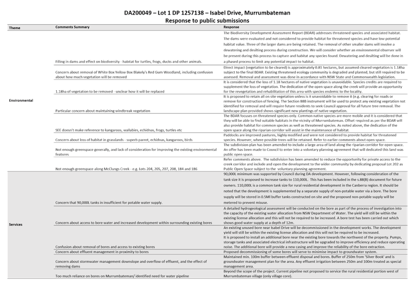
7.4 Development Application No DA200049 - Subdivision, Isabel Drive, Murrumbateman
SUMMARY
To present a report on Development Application No 200049 for a 101 lot subdivision of Lot 1 DP1257138, Isabel Drive, Murrumbateman. It is presented to Council as it attracted 65 submissions and involves a variation to the minimum lot size for one lot. Approval is recommended, subject to the submission of a revised Land Capability Assessment for effluent disposal and a Voluntary Planning Agreement for the open space.
|
That: 1. Development Consent be issued for a 101 lot subdivision of Lot 1 DP 1257138, Isabel Drive, Murrumbateman following receipt of a satisfactory revised Land Capability Assessment for effluent disposal 2. The dedication of the open space lot be supported, subject to conditions of Development Consent including a Voluntary Planning Agreement covering the dedication, associated works, and initial maintenance period 3. A further report be presented to Council on the draft terms of the Voluntary Planning Agreement |
FINANCIAL IMPLICATIONS
Resources for development assessment are provided for in the current Operational Plan.
POLICY & LEGISLATION
· Environmental Planning & Assessment Act 1979
· Environmental Planning & Assessment Regulation 2000
· Biodiversity Conservation Act 2016
· Water Management Act 2000
· National Parks & Wildlife Act 1974
· State Environmental Planning Policy (Infrastructure) 2007
· Yass Valley Local Environmental Plan 2013
· Yass Valley Settlement Strategy
· Murrumbateman Structure Plan
· South East & Tablelands Regional Plan 2036
· Yass Valley Community Engagement Strategy
· Yass Valley Development Contributions Plan 2018
· Road Standards Policy
· Building Line Policy
· Application Assessment & Decision Making Policy
· Water Supply for Rural Areas & Villages Policy
· Parks & Playgrounds Strategy
REPORT
1. Applications Details
|
Date Received |
- |
31 March 2020 |
|
Land |
- |
Lot 1 DP1257138, Isabel Drive, Murrumbateman |
|
Area |
- |
99.55ha |
|
Zoning |
- |
R2 Low Density Residential, R5 Large Lot Residential |
2. Site Description and Locality
The development site is approximately 100ha in size and located west-southwest of the Murrumbateman village. It is an irregular shape, with frontage to Isabel Drive, McIntosh Circuit, Colonial Place and Merryville Drive. The site is bordered by Shaw Winery, Merryville Estate and Carrington Park Estate and was formerly part of the Shaw Vineyard Estate but has been excised from that holding.
The site is generally undulating with the highest areas being towards the centre. McClungs Creek bisects the site and there are several other drainage lines and dams. Part of the site is identified as having significant native vegetation. There is currently no significant development located on the land other than bores and historically has been used primarily for stock grazing.
The site is subject to two zones and minimum lot sizes under the Yass Valley LEP 2013. The eastern portion is zoned R2 Low Density Residential with a minimum lot size of 6,500m2 and the western portion is zoned R5 Large Lot Residential with a minimum lot size of 1ha.
A Locality Plan is included in Attachment A.
3. Proposal
The Development Application was initially lodged for a 106 lot subdivision including 104 development lots and two open space lots. The proposal has been revised to 100 lots and one open space lot. The open space lot includes a shared horse/bike/pedestrian trail from Isabel Drive to Merryville Drive. The subdivision is proposed in two stages with stage one being the eastern portion and stage two the western portion.
The lot sizes range from 5,800m2 to 14,800m2, with the smallest (Lot 136) representing a variation to the 6,500m2 minimum lot size of.
A copy of the revised subdivision plan and the original subdivision plan are included in Attachment B.
4. Public Exhibition
Public exhibition included:
· Letters to 170 nearby properties determined by a buffer distance from the development site
· Notice to the Murrumbateman Progress Association
· Signs displayed at the site (McIntosh Circuit, Merryville Drive and Colonial Place)
· Notice on Council’s website and Facebook page
A total of 65 submissions were received including two broadly in support and 63 either raising matters of concern or objecting to the proposal.
A Planning Forum was held in July 2020 to provide an opportunity for submission authors and the Applicant to address Council prior to determination of the proposal. Five presentations were made, including two on behalf of the Applicant and three by submitters. A site meeting was also held with representatives of the Merryville Community Association.
The key issues raised in the submissions and at the planning forum relate to:
|
· Lot Layout and Open Space |
· Murrumbateman Services and Facilities |
|
· Lot Sizes and Variation to Minimum Lot Size |
· Development Contributions |
|
· Consistency with Settlement Strategy |
· Electricity and Internet |
|
· Access and Road Network |
· Bushfire Hazard |
|
· Paths and Cycleways |
· Aboriginal Cultural Heritage |
|
· Tree Removal, Vegetation and Biodiversity Impacts |
· Subdivision Management and Building Design Covenants |
|
· Additional Tree Buffer with Carrington Estate |
· Boundary Alignments Issues |
|
· Bore, Groundwater and Water Supply |
· Street Lighting |
|
· Onsite Effluent Disposal |
· Domestic Animals and Cat Containment |
|
· Stormwater Drainage and Dam Removal |
· Development Application Lodgement Timing |
|
· Murrumbateman School |
· Suggested Conflict of Interest |
Copies of the submissions are included in Attachment C and the Applicant’s response is in Attachment D.
5. Referrals
The application was referred to the Natural Resources Access Regulator (NRAR), WaterNSW, Department Planning, Infrastructure & Environment (Biodiversity & Conservation), and Transport for NSW (TfNSW). A copy of the referral responses are included in Attachment E.
5.1 Natural Resources Access Regulator (NRAR)
The application was referred to NRAR as it involves lots fronting and the crossing of, McClungs Creek. NRAR requested amendments to the lot layout to minimise impacts on waterfront land and the number of lots with frontages to the watercourses. The subdivision layout was amended to address these issues and NRAR has now issued their conditions for any approval that may issue.
5.2 WaterNSW
The application was referred to WaterNSW in relation to the supplementary bore water supply. The Applicant indicated the proposal will involve a new bore and therefore will require a new Water Access Licence (WAL). In relation to the new bore WaterNSW advised that a new water supply approval is required. Consent conditions can require evidence to be submitted of an amended or new water supply approval and WAL prior to the issue of any Subdivision Certificate. There is no guarantee that WaterNSW will issue amended or new approvals. However, the bore supply is secondary non-potable supply and is not a necessity to service the subdivision.
5.3 Department Planning, Infrastructure & Environment (Biodiversity & Conservation)
The application was referred to DPIE (B&C) as part of the site contains an Endangered Ecological Community (i.e. Tablelands Box-Gum Woodland) and to obtain advice regarding the open space. DPIE (B&C) raised concerns about the number of lots proposed with building envelopes adjacent to and within the area of the EEC. DPIE (B&C) recommended that the majority of lots within the biodiversity corridor become open space and be protected with a Vegetation Management Plan to facilitate the use of the space whilst ensuring environmental values are protected and managed. The amended subdivision layout includes all the biodiversity corridor being located within a public open space lot to address these concerns.
5.4 Transport for NSW (TfNSW)
The application was referred to TfNSW in response to submissions about the adequacy of the Barton Highway intersections (particularly McIntosh Circuit) which will serve as the main transport routes for the development. TfNSW do not raise an objection to the proposal. TfNSW have provided further comments for consideration for the assessment of the local road network, such as for speed design, service and construction vehicles, and alterative transport modes.
6. Assessment
An assessment of the DA has been completed in accordance with the planning legislation. It generally complies with the relevant planning controls, policies and guidelines, with the exception of one lot which involves a variation to the minimum lot size requirement. The following is a response to the planning issues identified, including those raised in the submissions. These comments have been considered in the assessment.
6.1 Lot Layout and Open Space
Concerns were raised with the lot layout and open space, particularly in the area around McClungs Creek and a secondary watercourse. The open space has been revised to protect biodiversity taking into account comments from submissions, DPIE (B&C) and staff. In response to the concerns raised, the following changes to the subdivision design have been made:
· Reducing the number of development lots from 106 to 100
· Number of development lots with watercourse frontage has been reduced to one, plus one open space lot
· Open space has been increased to extend from Merryville Drive to the top of the Merryville Common including the majority of McClungs Creek, the other creek/drainage line, and all of the vegetation corridor
· Realignment of the path/trail to reflect the additional area of open space
· Reducing size of three lots backing onto Marquess Place to facilitate increased open space
· Removing the building envelope adjacent to 15 Marqess Place
· Deleting the open space lot (stormwater lot) at the end of Colonial Place and consolidating this into a development lot
· Realignment of boundary between lots 105 and lot 106 to allow improved sight distance for property accesses
· Increasing the size of Lots 126-130 to facilitate stormwater outcomes and drainage back to McClungs Creek
The amended layout represents a significant improvement to the subdivision design, increasing open space and reducing environmental impacts.
The provision and dedication of open space to Council was raised in pre-lodgement discussions with the Applicant given that it is not identified in any open space strategy, masterplan or the Murrumbateman Structure Plan. The subdivision has been amended to increase open space around McClungs Creek and the biodiversity values. The Applicant proposes to dedicated this area to Council and proposes a Voluntary Planning Agreement (VPA) for its development and management (refer Attachment F). The terms of the VPA will need to be negotiated with the Applicant.
6.2 Lot Sizes and Variation to Minimum Lot Size
The proposed lots sizes range between 5,800m2 to approximately 14,800m2 with the smaller lots generally being located on the eastern portion of the site and the larger ones on the western portion.
The Yass Valley LEP 2013 specifies a minimum lot size of:
· 6,500m2 for the R2 Low Density Residential area
· 10,000m2 for the R5 Large Lot Residential area
The proposal complies with the minimum lot size requirements with the exception of proposed Lot 136 which reduces the minimum lot size from 6,500m2 for this lot to 5,800m2 (i.e. 11% variation). The variation is proposed to enable the adjoining vegetation to be retained entirely in the open space lot rather than being fragmented by a boundary fence line.
The request for a variation to the development standard (refer Attachment G) includes the following justification:
· The subdivision layout has been modified to increase the amount of open space reflecting comments made from government agencies and Council
· The development and variation remain consistent with the objectives of the R2 Low Density Residential zone
· The variation allows a boundary to be adopted which avoids vegetation
· The variation is for one lot representing less than one percent of overall the development
· The lot remains consistent with surrounding lot sizes and subdivision pattern
The extent and nature of the proposed variation is considered to be minor in the context of the subdivision and represents a positive planning and environmental outcome by retaining the existing vegetation wholly within the open space lot. It is therefore considered that there is sufficient planning basis to support the proposed variation to the minimum lot size for Lot 136.
6.3 Consistency with Yass Valley Settlement Strategy
The consistency of the proposed development with the Yass Valley Settlement Strategy has been questioned suggesting that the future growth plan for Murrumbateman is to the north. Historically this area has been zoned for rural residential and low density residential purposes and the Settlement Strategy does not envisage a change to this area from the current zoning. The proposal is therefore consistent with the current planning controls in the LEP and the Strategy.
6.4 Access and Road Network
Concerns have been raised in relation to access and the road network, including for new road connections, the adequacy of the existing network, speed limits, and property accesses.
6.4.1 New Road Connections
The new roads are proposed to connect to Isabel Drive to the west of Shaw Winery entry, McIntosh Circuit to the north of Woodleigh Drive, and into Colonial Place.
The most appropriate traffic management solution at the intersection of McIntosh Circuit and the new road is the construction of a roundabout. This would facilitate this intersection being the preferred route for a large proportion of lots within the subdivision. In addition it will reduce the additional traffic generation that will use the Isabel Drive/McIntosh Circuit intersection, especially for turning right (south) onto McIntosh Circuit from Isabel Drive. The roundabout in this location will also reduce traffic speed. A requirement for a roundabout is consistent with the strategic use of roundabouts at either end of Merryville Drive.
All other intersections within the subdivision will comply with engineering standards.
6.4.2 Adequacy of Existing Road Network
The adequacy of the existing road network, especially McIntosh Circuit, the Barton Highway, and the McIntosh Circuit/Barton Highway intersection and the assumptions of the Traffic Impact Assessment (TIA) have been raised.
A revised traffic impact assessment has included the following changes:
· Traffic distribution assumption of 50% trips to Canberra and 50% to Yass has been corrected to include 95% to Canberra and 5% to Yass
· Utilised 2017 traffic count data of McIntosh Circuit rather than using assumptions based on the number of existing dwellings
The assessment makes assumptions regarding routes taken for traffic travelling to and from Canberra and Yass using McIntosh Circuit. In reality, traffic travelling into Murrumbateman village are likely to use the same route as those travelling to Yass, being north on McIntosh Circuit and then South Street (and likely onto West Street and Hercules Street).
The use of 2017 traffic count data is supported but it should be noted that since 2017, the Scrubby Lane connection to McIntosh Circuit from the Jiparu Estate has been opened, however those lots are either still vacant or under construction. Other subdivisions including on the corner of Dog Trap Road and Isabel Drive, and 17 South Street, are yet to have any lots released.
The additional traffic generation of this development and nearby subdivisions are within the capacity of the road network but increased traffic generation is likely to result in additional queue times at the McIntosh Circuit/Barton Highway intersection and for properties exiting existing driveways along McIntosh Circuit. A number of submissions suggested that further subdivision in Murrumbateman should not proceed until the Barton Highway is duplicated. Whilst the issues associated with the Barton Highway are acknowledged, Council has not adopted a position to prevent other subdivisions in the Murrumbateman and Yass.
Roundabout have been requested to be constructed on each existing road intersection of McIntosh Circuit between the development site and the Barton Highway, and the installation of traffic signals at the Barton Highway intersection. This is not considered to be necessary based on the traffic volumes and the previous upgrade to the Barton Highway intersection. However a new roundabout at the proposed new intersection to the subdivision off McIntosh Circuit will assist with management of the traffic generated.
The condition of McIntosh Circuit and in particular the potholes are acknowledged and these are considerations for Council’s road maintenance programs. The opportunity for potential heavy patching or rehabilitation works either this year or next year will be investigated regardless of whether the subdivision proceeds.
6.4.3 Speed Limit and Heavy Vehicle Load Limit
Some submissions requested that the speed limit on McIntosh Circuit and Isabel Drive be reduced from 70km/h to 60km/h (and in some cases to 50km/h) and a heavy vehicle load limit or curfew be introduced for construction traffic on McIntosh Circuit.
Speed limits are determined by TfNSW. The speed limit on McIntosh Circuit has recently been reviewed based on current conditions and the outcome is pending.
There is no basis for a heavy vehicle load limit on McIntosh Circuit. It is a public road and road registered vehicles are entitled to use it. The maintenance of local roads due to wear and tear by all vehicles (including heavy vehicles) is a responsibility for Council.
Amenity impacts as a result of heavy vehicle movements during construction are managed through conditions on the Development Consent.
6.4.4 Location of Property Accesses
Concern has been raised in relation to property accesses, particularly with lots that front McIntosh Circuit or Isabel Drive. The subdivision proposes two lots with access from Isabel Drive and three lots with access from McIntosh Circuit. Corner lots with frontage to existing roads and new roads are proposed to have property access from the new road.
Council’s Road Standards Policy specifies requirements in relation to the location of property accesses, including sight distances for the speed environment and that corner lots must have access from the less trafficable road. The location of property accesses is considered acceptable and will comply with the requirements of this Policy.
6.4.5 Bus Stops
Provision for bus stops within the subdivision can be required as a condition of any Consent that may be issued. The location of bus stops outside of the subdivision (i.e. further along McIntosh Circuit) are outside of the scope of this proposal.
6.4.6 Colonial Place Name
Colonial Place is proposed to become a through road connecting to the new road in the subdivision. It is noted within submissions that a ‘Place’ is a short, enclosed roadway. In accordance with the NSW Address Policy and User Manual a ‘Place’ is a suitable name for a closed road only.
Provision had also been made in the Carrington Park subdivision for a further road connection from Colonial Place rather than closing it off with another development lot. It appears that the implications of naming it as a ‘Place’ were not fully considered at the time of this subdivision.
The need to rename Colonial Place can be further considered separately as it involved properties external to this current subdivision proposal. Seven properties are currently addressed as Colonial Place and renaming may be disruptive for those residents. Renaming Colonial Place needs further consideration and can be done outside of any Development Consent.
6.4.7 Saxon Place
The initial subdivision design provided for a future road connection from Merryville Drive to the small cul-de-sac on the western portion of the subdivision via the unformed Saxon Avenue. Although this future connection was originally envisaged when Merryville Estate was planned, the way lots have been developed has meant that its construction would potentially have an adverse impact on the amenity of those residents.
Construction of Saxon Avenue is not a Council priority. The Merryville Community Association have expressed an interest in closing and purchasing the land. This can be examined separately to the current application. The revised subdivision design allows provision for a right of way in case there is ever a future need for a secondary emergency connection to be constructed.
6.5 Paths and Cycleways
The provision of pedestrian, horse and cycle connections has been raised in submissions. Concerns were also raised about missing links, particularly along McIntosh Circuit to the Barton Highway
The Applicant proposes a pedestrian/horse/cycle trail running from Isabel Drive to Merryville Drive through the open space which is consistent with the Murrumbateman Structure Plan.
The rural residential nature of Murrumbateman outside of the village results in larger lots and distances between them compared to higher density urban areas. This makes it unrealistic for a path to be provided on every road. It is recommended that a single path be constructed along the verge of roads numbered 1, 2 and 4 from the intersection of McIntosh Circuit to the open space lot where it meets the horse trail. It should be noted that Murrumbateman Winery Trail project will include a shared path along McIntosh Circuit from the Barton Highway and joining with the existing path at Acacia Way.
6.6 Tree Removal, Vegetation and Biodiversity Impacts
Tree and vegetation removal as well as biodiversity impacts particularly around McClungs Creek and along existing boundaries within Merryville Estate have been raised. The revised subdivision design reduces the need for tree removal and includes a biodiversity corridor within a proposed public open space area. This is consistent with the recommendations of DPIE (B&C).
Building envelopes have been sited so that trees are located outside of them and will be further supported by a title restriction prohibiting the removal of vegetation by future landowners unless otherwise approved. The stands of vegetation along the existing boundaries within Merryville Estate are not proposed to be removed with the exception of where new fences connect/abut into existing fences.
It is proposed to remove 0.80ha of Box Gum Woodland from where the road crosses over from the eastern to western portion of the subdivision, for the construction of the horse trail and in another isolated locations to facilitate fence construction. One dead paddock tree will also be removed which is identified as containing hollows and potentially habitat for superb parrot.
The Biodiversity Development Assessment Report (BDAR) concludes offsets credits are required for the removal of the Box Gum Woodland and the dead paddock tree. The BDAR concludes that the removal of the Box Gum Woodland does not trigger the Commonwealth’s Environment Protection & Biodiversity Conservation Act 1997.
The removal of the dams will not have an impact on threatened species, however does contain habitat for long-necked turtles. The BDAR recommends that a dam dewatering plan be prepared and that these turtles be captured and relocated by an experienced fauna catcher. This should be included as a condition of any Consent that may be issued.
DPIE (B&C) have reviewed the report and are satisfied with its methodology. Concerns about the lot layout and the biodiversity corridor have been addressed through the revised subdivision plan ensuring the retention of the biodiversity values.
6.7 Additional Tree Buffer with Carrington Estate
The provision of an additional tree buffer between this subdivision and properties at the back of Carrington Park Estate as a privacy buffer has been raised. Council does not have any policy requirements for this and the proposed development is not considered to have a privacy impact to the extent that a buffer is required. Individual lot owners in both Carrington Park and the new subdivision can undertake their own boundary planting if privacy is of a concern.
6.8 Bore, Groundwater and Water Supply
Bore, groundwater and water supply issues have been raised. The development is not connected to a reticulated potable water supply, with rainwater tanks being the primary potable water supply with a proposed supplementary non-potable reticulated bore water supply.
The reliability of groundwater supply has been questioned and the impact that this may have on existing supply to other subdivisions, particularly in drought conditions. Water supply work approvals and WALs for bores are issued by WaterNSW under the Water Management Act 2000. Testing of the existing bore suggests that the bore is operating well and there is enough water and pressure. If WaterNSW do not grant approvals for the bore supply then the subdivision can be serviced by rainwater tanks only.
A Communal Water Management Statement will need to be prepared if the bore is approved and included as a title restriction detailing limits on use, ongoing management, equitable distribution, water restrictions, dispute resolution, etc.
Council’s standard requirements for rainwater tanks is a minimum of 45,000L for a dwelling less than 150m2 in area and 90,000L for larger dwellings. In response to submissions, the Applicant proposes to increase this to a minimum 120,000L through a title restrictions. This is supported, however a minimum 45,000L is appropriate for dwellings less than 150m2 as these are likely to be granny flats or secondary dwellings.
Concern was also raised in relation to the noise levels from the existing diesel bore which services Carrington Park. The DA proposes to replace this with an electric pump, with any other new pump to also be electric. This can be included as a Consent condition if the proposal is approved.
6.9 Onsite Effluent Disposal
The capability for onsite effluent disposal has been questioned, including whether this would adversely affect groundwater.
The submitted Land Capability Assessment indicates that there is generally adequate area on each lot for effluent disposal. However a revised assessment to reflect the final lot layout and subdivision design adjustments will need to be submitted prior to the issue of any Consent to allow for the inclusion of any updated management requirements in the final conditions.
Each future dwelling application will require a separate waste water report and system design based on the size of the dwelling house, etc.
6.10 Stormwater Drainage and Dam Removal
Concern was raised in relation to the filling of six dams and the potential stormwater drainage impacts including on neighbouring development. The revised subdivision layout now proposes the removal of three dams and the reshaping of the remaining three. The size of proposed lots-126-130 have also increased to facilitate improved stormwater outcomes and drainage back to McClungs Creek. Concept stormwater plans have been reviewed and the detailed design will be required prior to issuing a Subdivision Works Certificate. Flood modelling has also been completed and indicates that all building envelopes are outside the 1% AEP flood event.
The submissions also suggest a higher design standard for stormwater drainage be adopted to allow for increased rainfall events associated with climate change. Current design standards are generally for a 1 in 5 and 1 in 100 year rainfall event.
6.11 Murrumbateman School
The lack of a school in Murrumbateman meaning that children must travel to Canberra and Yass limiting the opportunity for sense of community. The need for a school has been long recognised by Council and the Murrumbateman community.
At the last State election the Government made a commitment to fund the establishment of a school in Murrumbateman. The State Government has recently sought expressions of interest for a suitable site in Murrumbateman to accommodate the construction of a primary school by 2023. It is understood that a site has been selected however at the time of compiling this report an announcement on the successful site has not be made.
6.12 Murrumbateman Services and Facilities
Concerns with the level of services and facilities within Murrumbateman have been raised with the suggestion that there should be no further growth or development until these services (e.g. health, education, etc) are all in place. Some submissions recognised that growth in Murrumbateman from development does present an opportunity for the further growth of services and facilities in time. Conversely, other submissions convey that they would like for a rural village setting to be retained.
Open space, roads, school, and internet and electricity are discussed elsewhere in this report. A number of the services and facilities referred to are outside of Council jurisdiction and are the responsibility of State Government.
6.13 Development Contributions
The submissions request confirmation that development contributions will be levied and suggest the amount or the purpose they should be levied for. Under the Yass Valley Development Contributions Plan 2018 a contribution of $33,392 will be levied based on 1% of the estimated cost of development being $3,392,000 and a VPA is proposed for the public open space. A further development contribution will levied for the construction of the dwellings or other development on the lots. All development contributions are pooled to undertake identified infrastructure projects in Yass Valley.
6.14 Electricity and Internet
The adequacy of electricity and internet supply within Murrumbateman has been questioned and the impact that the additional development will have on those services.
The developer will be required to prepare a design for the provision of electricity infrastructure for approval by the infrastructure service provider. A Notice of Arrangement (NoA) from Essential Energy for electricity, and a Certificate of Practical Completion for fibre-ready internet infrastructure must be submitted prior to the issue of a Subdivision Certificate. A Consent condition can also be imposed requiring submission of evidence prior to the issue of a Subdivision Works Certificate demonstrating that:
· Suitable arrangements for electricity supply can be made available including with consideration of impact on existing capacity and reliability, and the opportunity for feed-in from new lots
· Suitable arrangements for telecommunications service (fixed-line NBN fibre) can be made available including with consideration of impact on existing capacity and reliability
6.15 Bushfire Hazard
Bushfire hazards have been raised particularly for access in and out of the subdivision. The subject land is not identified as being bushfire prone. However the submitted bushfire due diligence assessment concluded that even though the land is not bushfire prone, the development will meet the requirements under Planning for Bushfire Protection.
6.16 Aboriginal Cultural Heritage
An Aboriginal Cultural Heritage Assessment has now been completed and the report found that the site does contain landscape features which indicates an increased likelihood of presence of Aboriginal objects, with a site survey identifying three new Aboriginal sites/objects. The assessment indicates that these sites are typical of the region and have little research or scientific potential, however the social or cultural significance of these could only be determined by the Aboriginal community.
The sites found are located within the riparian corridor that is proposed to be open space. The assessment recommends that if these sites will be disturbed during revegetation works then an Aboriginal Heritage Impact Permit (AHIP) will be necessary for the objects to be removed and replaced. Where avoidance is possible, then these sites should be fenced during works and the fences put in place by a qualified archaeologist and members of the Onerwal Local Aboriginal Land Council. The sites will also need to be recorded and their protection considered in the plan of management for this land.
6.17 Boundary Alignment Issues
The submissions detail boundary alignment issues between Merryville community land and the subject site. The Merryville Community Association had their own survey prepared and inconsistencies with boundary location had been identified between the two surveys. A site meeting was held between the Merryville Community Association, Applicant and staff. The boundary location issue has now been resolved by the two surveyors and the Applicant has advised that they will consult with individual lot owners (including Merryville Community Association) in relation to the movement and construction of any new fences.
6.18 Subdivision Management and Building Design Covenants
The proposed subdivision is a Torrens Title subdivision rather than Community Title meaning that no community association will be established. The reticulated bore water scheme will be established through a separate Communal Water Management Statement.
The submissions also question whether there will be specific building guidelines and covenants imposed. At this time there are no specific built form guidelines or covenants that have been put forward other than the location of building envelopes, restriction on tree removal, and size of rainwater tanks. Council generally relies on development controls to shape development and usually only requires covenants where it is to address a particular issue or concern (such as size of rainwater tanks). The Applicant may implement their own covenants, however Council would not be the enforcement authority for them.
6.19 Street Lighting
The submissions suggest that the provision of street lighting should be minimal to provide suitable illumination but not to adversely impact upon the night skies and environment. The level of street lighting should be consistent with surrounding development (which is minimal) and details can be required prior to the issue of a Subdivision Works Certificate.
6.20 Domestic Animals and Cat Containment
The impact that additional properties with domestic animals will have on wildlife (especially birds) and stock has been raised. A suggestion for this area to be cat containment was also made.
The Companion Animals Act 1998 advocates responsible pet ownership. The Act does not require cats to be contained within a property. Future residents must comply with the requirements of this legislation.
6.21 Development Application Lodgement Timing
The proposal was lodged at the end of March 2020 and submissions have raised the timing of its lodgement in relation to the COVID-19 situation. This was taken into consideration resulting in public exhibition being delayed until May 2020 to allow an opportunity for submissions to be made. In addition a Planning Forum was held to ensure submitters had an opportunity to address Councillors and clarify concerns. .
6.22 Conflict of Interest
A conflict of interest between Council and Elton Consulting, and whether Council may have a relationship with the developer has been mentioned. This suggestion is based on the engagement of Elton Consulting by Council to undertake work on the Yass Valley Settlement Strategy.
The application has been prepared by Elton Consulting on behalf of the developer, Next Level Eighteen Pty Ltd. There is no relationship between Council and the developer. Elton Consulting were engaged in 2016 by Council to prepare the Settlement Strategy. Elton Consulting completed this project and are no longer engaged by Council. Elton Consulting completed a probity plan to manage any potential conflicts of interest during the preparation of the Strategy. However, it is very important to note that in the context of this application, the land was already zoned under the Yass Valley LEP 2013 for the subdivision proposed (and previously under the Yass LEP 1987) and therefore does not rely on the provisions of the Strategy to make it permissible.
7. Conclusion
From an assessment of the proposal and consideration of issues raised in submissions, it is recommended that a conditional Development Consent be issued following the receipt of a satisfactory final Land Capability Assessment for effluent disposal. It is also recommended that the dedication and acceptance of the open space be supported, subject to conditions of Development Consent which include a requirement for a VPA. Draft conditions are included as Attachment H.
Key Pillar 1. Our Environment
CSP Strategy EN1 - Protect and enhance the existing natural environment, including flora and fauna native to the region
Delivery Program Action EN1.1 - Protect our natural assets in line with community values
Operational Plan Activity EN1.1.1 – Ensure assessment of development applications protects our natural environment
ATTACHMENTS: a. Locality and Notification Plan ⇩
b. Revised and Orginal Plans of Subdivision ⇩
c. Submissions (Under Separate Cover) ⇨
d. Applicant Response to Submissions ⇩
e. Referral Agency Responses ⇩
f. VPA Letter of Offer ⇩
g. Development Standard Variation Request ⇩
h. Draft Conditions ⇩
7.4 Development Application No DA200049 - Subdivision, Isabel Drive, Murrumbateman
Attachment a Locality and Notification Plan
7.4 Development Application No DA200049 - Subdivision, Isabel Drive, Murrumbateman
Attachment b Revised and Orginal Plans of Subdivision
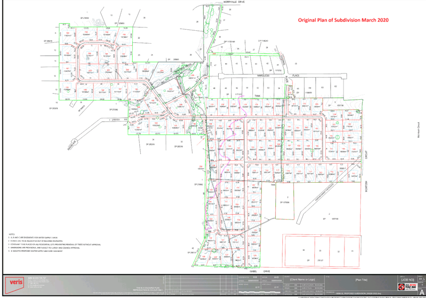
Attachment d Applicant Response to Submissions
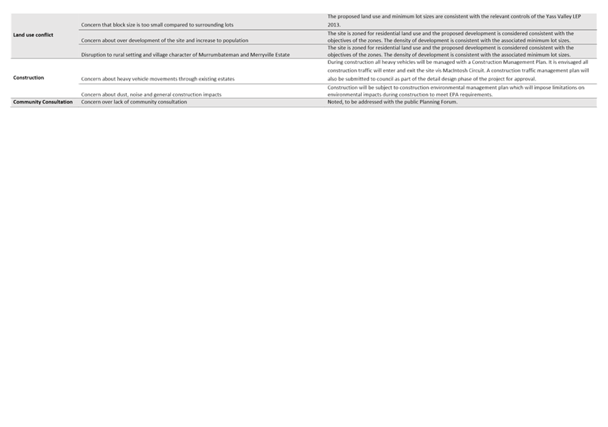
Attachment e Referral Agency Responses
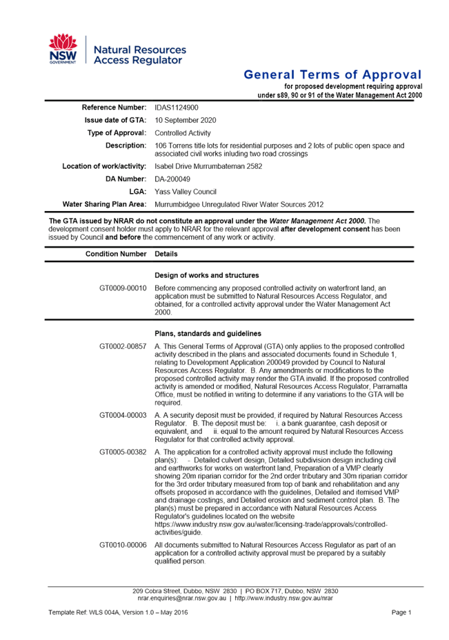

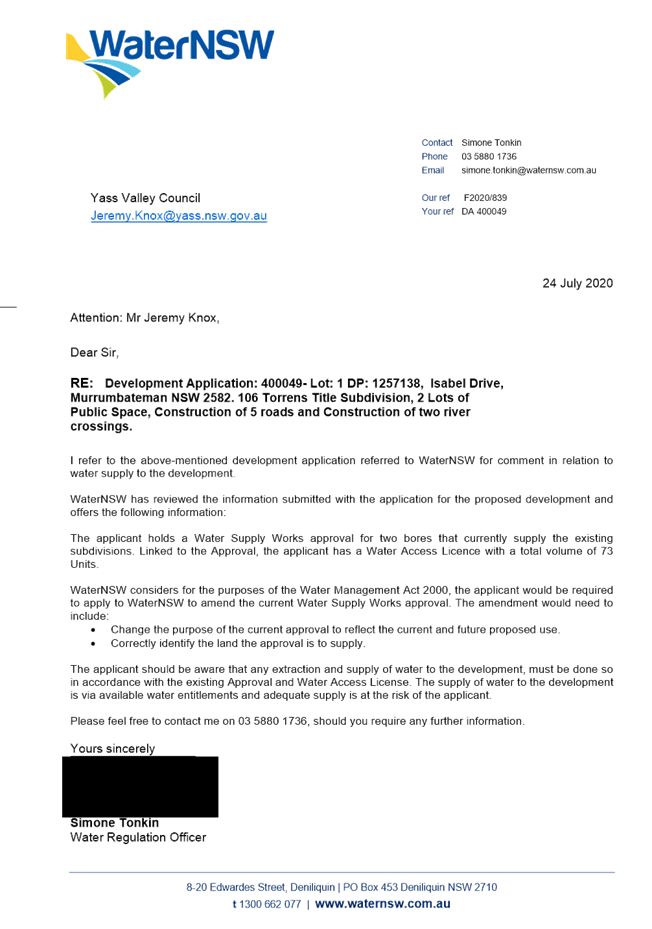
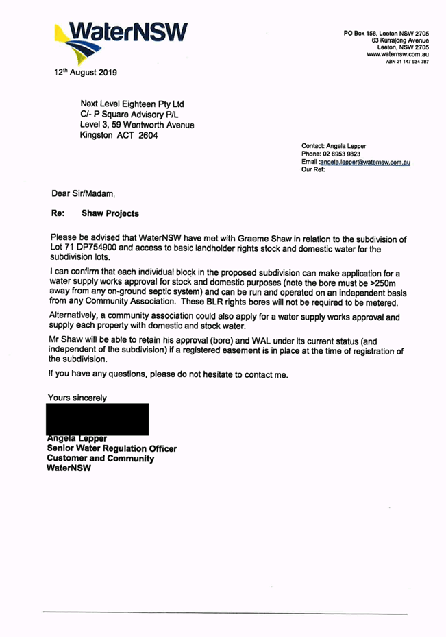
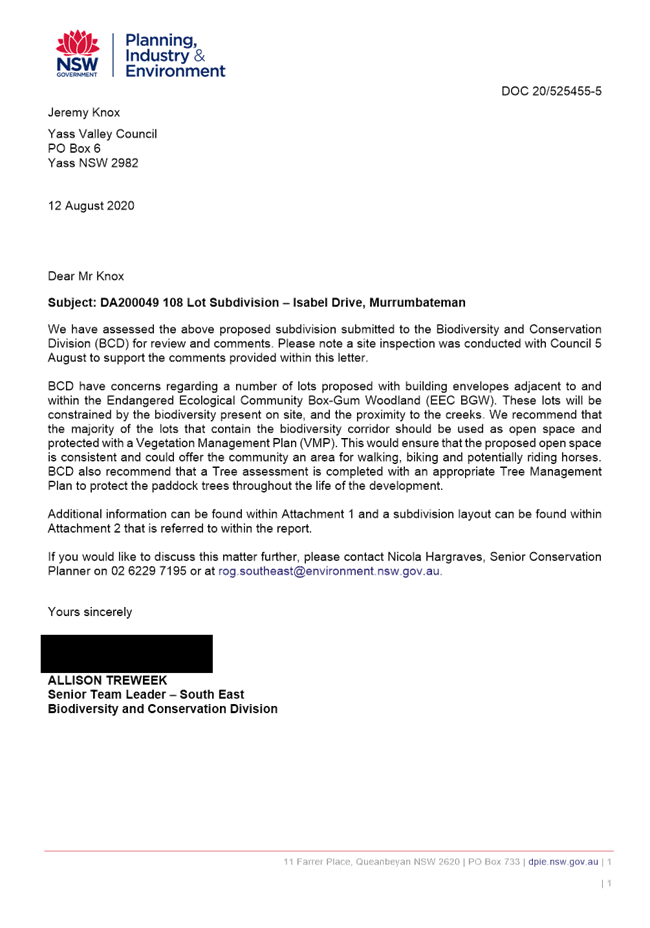
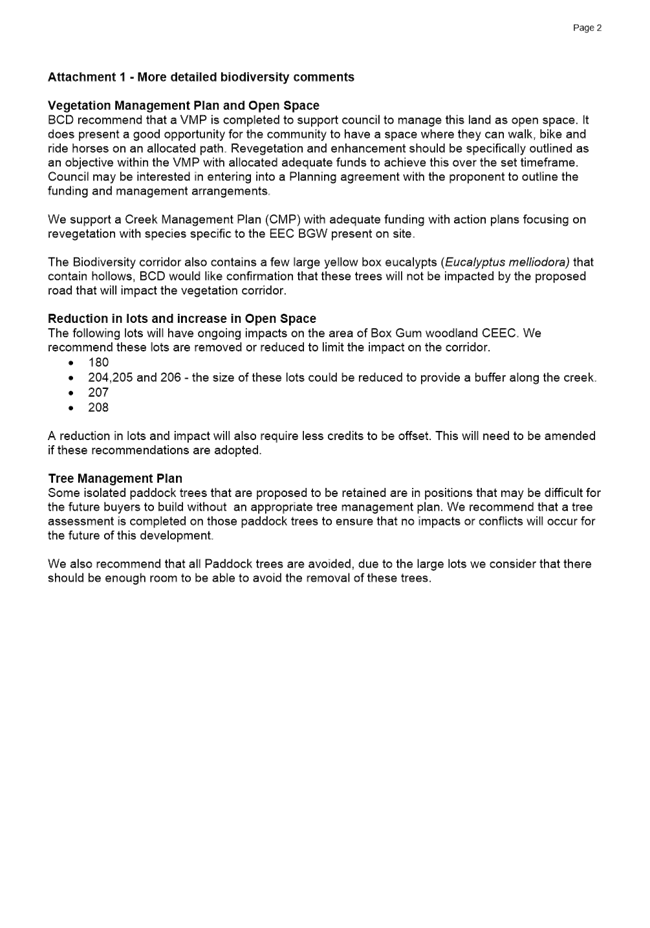


Attachment f VPA Letter of Offer
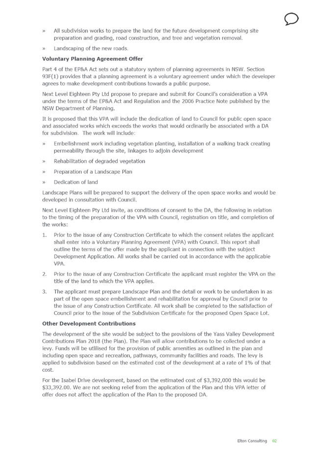

Attachment g Development Standard Variation Request
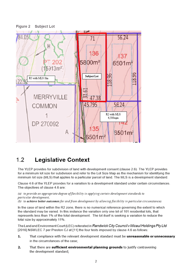
Attachment h Draft Conditions
DA200049 – DRAFT CONDITIONS – ISABEL DRIVE, MURRUMBATEMAN
PART A - GENERAL CONDITIONS (ALL STAGES)
(1) Consent is granted generally in accordance with the plans and details submitted to Council with the Development Application. The plans of subdivision has been stamped and attached to this consent. The development shall be carried out in accordance with the stamped plan or as modified by these conditions.
(2) This approval relates only to the development referred to in the development application and specifically does not amount to an approval or acceptance by the Council of any works or buildings already erected on the land, whether or not those works or buildings are the subject of a prior development or building approval.
(3) A Subdivision Works Certificate, as defined by the Environmental Planning and Assessment Act 1979, shall be obtained for all engineering works prior to any works commencing on site. Council’s fee for providing a Construction Certificate is levied in accordance with Council’s Management Plan relevant at the time of payment.
(4) All engineering design and construction work shall be undertaken in accordance with the following, current at the time of the Engineering Construction Certificate being issued:
· Council's Road Standards Policy RD-POL-09
· Specific Requirements of Transport for NSW
· Council’s Design and Construction Specification – AUS-SPEC #1
· Australian Standards and
· AustRoads
(5) The developer at no cost to Council or Transport for NSW, shall make any necessary alteration, relocation or enlargement to public utilities whether caused directly or indirectly by this proposed subdivision.
(6) Public access to the site and construction works, materials and equipment on the site is to be restricted, when construction work is not in progress or the site is unoccupied.
(7) The capacity and effectiveness of runoff and erosion control measures shall be maintained at all times to the satisfaction of Council as shall any techniques to suppress dust and the tracking of sediment onto existing sealed roads;
(8) The applicant must adhere to the following days and hours of operation for subdivision works associated with the development unless otherwise approved by Council in writing:
· 7.00 am to 6.00 pm Monday to Friday
· 8.00 am to 1.00 pm Saturday
· No work on Sundays or Public Holidays
(9) Noise, dust and odour generated as a result of the development must comply with the provisions of the Protection of the Environment Operations Act 1997.
PART B - PRIOR TO ISSUE OF SUBDIVISION WORKS CONSTRUCTION CERTIFICATE (ALL STAGES)
(1) The applicant shall submit evidence that suitable arrangements for electricity supply can be made available to service the proposed development, including with consideration of impact on existing capacity and reliability, and the opportunity for feed-in from new lots.
(2) The applicant shall submit evidence that suitable arrangements for telecommunications service (fixed-line NBN fibre) can be made available to service the proposed development, including with consideration of impact on existing capacity and reliability.
(3) Prior to the issue of any Subdivision Works Certificate for Stage 1 the Applicant shall enter into a Voluntary Planning Agreement (VPA) with Council. The VPA shall outline the terms of the offer made by the Applicant and accepted by Council in connection with the subject Development Application. The terms of the offer shall generally include:
(a) A Landscape Plan, Vegetation Management Plan and Riparian Restoration Plan and detail the work to be undertaken in as part of the open space embellishment and rehabilitation.
(b) Facilities to be provided within the open space are to be consistent with a Category 3 Park in accordance with Council’s Park & Playground Strategy 2017.
(c) That all work shall be completed to the satisfaction of Council prior to the issue of the Subdivision Certificate for the proposed Open Space lot.
(d) Prior to the issue of any Subdivision Works Certificate the Applicant must register the VPA on the title of the land to which the VPA applies.
(e) The maintenance responsibility period for the Applicant shall be five (5) years from the date of the issue of a Subdivision Certificate.
(f) A Memorandum of Understanding in relation to the provision of easements and ongoing access and responsibilities for the private non-potable bore water supply infrastructure proposed to be located and cross the open space lot dedicated to Council.
(4) A Construction Environmental Management Plan to address construction activity is to be prepared and submitted to Council. The Construction Environmental Management plan shall include:
· Details for waste management
· Details for minimising impacts on neighbouring properties
· Details for minimising impacts on the road network
· The discouragement of construction traffic through Carrington Park estate
· The Biodiversity Management Plan
· The dam dewatering plan.
(5) The class and number of ecosystem credits in Table 1 must be retired to offset the residual biodiversity impacts of the development.
The requirement to retire credits may be satisfied by payment to the Biodiversity Conservation Fund of an amount equivalent to the class and number of ecosystem credits, as calculated by the Biodiversity Offsets Payment Calculator.
Note: Prices of credits in the Biodiversity Offsets Payment Calculator are subject to change. The amount payable to discharge an offset obligation will be determined at the time of payment.
Table 1 Ecosystem credits required to be retired – like for like
|
Impacted plant community type |
Number of ecosystem credits |
IBRA sub-region |
Plant community type(s) that can be used to offset impacts from the development |
|
PCT 1330 – Yellow Box Blakelys Red Gum grassy woodland on the tablelands, South Eastern Highlands Bioregion
|
12 |
Murrumbateman, Bondo, Crookwell, Inland Slopes, Monaro, Murrumbateman and Snowy Mountains.
Or
Any IBRA subregion that is within 100 kilometres of the outer edge of the impacted site.
|
White Box Yellow Box Blakelys Red Gum Woodland.
|
Evidence of the retirement of credits or payment to the Biodiversity Conservation Fund in satisfaction of Table 1 requirements must be provided to Council prior to issue of a Subdivision Works Certificate.
Evidence must be provided in accordance with the following:
(a) Retirement of credits: A credit retirement report issued by OEH confirming credit transactions.
(b) Payment to the Biodiversity Conservation Fund: A section 6.33 Statement Confirming Payment into the Biodiversity Conservation Fund issued by the Biodiversity Conservation Trust.
(6) The class and number of species credits in Table 2 must be retired to offset the residual biodiversity impacts of the development.
The requirement to retire credits may be satisfied by payment to the Biodiversity Conservation Fund of an amount equivalent to the class and number of species credits, as calculated by the Biodiversity Offsets Payment Calculator.
Note: Prices of credits in the Biodiversity Offsets Payment Calculator are subject to change. The amount payable to discharge an offset obligation will be determined at the time of payment.
Table 2 Species credits required to be retired – like for like
|
Impacted species credit species |
Number of species credits |
IBRA sub-region |
|
Polytelis swainsonii / Superb Parrot |
1 |
Murrumbateman, Bondo, Crookwell, Inland Slopes, Monaro, Murrumbateman and Snowy Mountains.
Or
Any IBRA subregion that is within 100 kilometres of the outer edge of the impacted site. |
Evidence of the retirement of credits or payment to the Biodiversity Conservation Fund in satisfaction of Table 2 requirements must be provided to Council prior to the issue of a Subdivision Works Certificate.
Evidence must be provided in accordance with the following:
(a) Retirement of credits: A credit retirement report issued by OEH confirming credit transactions.
(b) Payment to the Biodiversity Conservation Fund: A section 6.33 Statement Confirming Payment into the Biodiversity Conservation Fund issued by the Biodiversity Conservation Trust.
(7) A Biodiversity Management Plan must be submitted to and approved by Council. The Biodiversity Management Plan may form part of a Construction Environmental Management Plan.
The Biodiversity Management Plan must:
· Identify the development site as per the Biodiversity Development Assessment Report and approved plans
· Identify areas of land that are to be retained as outlined in the Biodiversity Development Assessment Report
· Include a Statement of Commitments which identifies all measures proposed in the Biodiversity Development Assessment Report to mitigate and manage impacts on biodiversity. The statement must indicate what the measure is, when and how often it is to be applied and who is responsible for undertaking the measure.
· State that construction impacts will be restricted to the development site and must not encroach into areas of retained native vegetation and habitat. All materials stockpiles, vehicle parking, machinery storage and other temporary facilities must be located within the areas for which biodiversity impacts were assessed in the Biodiversity Development Assessment Report.
(8) Engineering drawings for the provision of access to each lot shall be submitted to Council’s Engineering Department for approval in accordance with:
· Council’s Roads Standards Policy RD-POL-09 and
· Council’s Design and Construction Specification – AUS-SPEC #1.
(9) Engineering drawings for the construction of all roads shall be submitted to Council’s Engineering Department for approval in accordance with:
· Council’s Roads Standards Policy RD-POL-09 and
· Council’s Design and Construction Specification – AUS-SPEC #1.
Note: All roads must be constructed in accordance with Local or Cul-De-Sac standards as specified for Yass and Murrumbateman Township Roads within the Council’s Road Standards Policy.
Note: Roadside drainage shall be constructed along the frontage of the subject land adjacent to all roads. Where kerb & and gutter or flush kerb (if approved by the Director of Infrastructure & Assets) standards are to be in accordance with Council’s Roads Policy RD-POL-09.
(10) The Engineering Drawings for the construction of roads shall provide for the provision of larger vehicles such as public transport service and construction vehicles (e.g. garbage trucks, delivery trucks).
(11) All cul-de-sacs shall have a 12m turning radius and provided with an asphaltic concrete wearing surface. Minimum standard 40mm thick AC14. In accordance with Council’s Road Standards Policy RD-POL-9. The road reserve will need to be increased at cul-de-sac ends to cater for the turning radius and road verge.
(12) The Engineering Drawings for the construction of roads shall provide for alternative means of travel to the motor vehicle. Facilities are required to be extended to and provided through the subdivision for the safe and effective movement of pedestrians and cyclists to nearby facilities.
(a) A shared pathway 2.5m wide, 100mm thick, reinforced concrete or asphalt on 50mm compacted road base shall be provided on new roads #1, #2 and #4 on the eastern portion of the development (east of the open space lot and horse trail path).
(b) A horse trail path is to be provided from Isabel Drive to Merryville Drive as shown on the approved plan of subdivision. Details are to be provided on the engineering drawings.
(13) Engineering drawings associated with the design of creek crossings and waterways are to be provided to Council for approval. The design shall be undertaken by a suitable qualified engineer and designed in accordance with Council policies, Council’s Design and Construction Specification –AusSpec#1, and relevant standards.
As part of the design, calculations of the catchment, flow velocities and volumes will need to be submitted to Council as well as a suitable proposal for upstream and downstream erosion protection. Details of road approaches to the crossing are to be supplied as part of these drawings.
(14) Bus stop facilities are to be provided within the estate at appropriate intervals for the convenience of the user in accordance with relevant guidelines. Bus shelters are to be of a construction consistent with shelters recently installed by Council. Show bus stop locations on the drawings.
(15) Engineering drawings associated with the drainage of stormwater shall be submitted to Council’s Engineering Department for approval in accordance with Council’s Stormwater Policies and Design and Construction Specification – Ausspec#1.
(16) Engineering drawings must include details of the discharge of stormwater off the site (including quantities for various storm event and is to include stormwater that falls on the site or enters the site from upstream), what is proposed to manage the discharge (including details of any infrastructure etc.), the potential downstream effects of such discharges and actions proposed to ameliorate such effects and what is proposed to ameliorate any effects on the site from stormwater from upstream of the site.
(17) An overland flow path to accommodate the discharge from a 1 in 100 year storm event shall be provided, including the provision of an easement where this flow path traverses private property. Details of any stormwater retention or water quality basins are to be provided.
(18) A Design Certification Report relating to the detailed engineering design work shall be submitted to Council as per Council’s Design Specification - AusSpec #1, Annexure DQS-A.
Note: This Design Report shall provide evidence that suitably qualified designers have designed each component of the engineering works for the development.
(19) A list of three street names, for each new street shall be submitted to Council for consideration and approval in accordance with Council’s Naming of Roads Policy RD-POL-6.
PART C - PRIOR TO ISSUE OF SUBDIVISION WORKS CONSTRUCTION CERTIFICATE (STAGE 1 ONLY)
(1) Engineering drawings for the design and construction of a roundabout at the intersection of the new subdivision road and McIntosh Circuit are to be submitted to Council’s Infrastructure & Assets Division. As a minimum, the pavement of the roundabout is to be asphaltic concrete.
Note: The centre of the roundabout shall be concrete or asphalt
(2) The Engineering Drawings for the construction of roads shall provide for the provision of alternative access in the initial stage should an incident occurs at or near the proposed intersection to Isabel Drive for accessibility for households and emergency purposes.
PART D - PRIOR TO SUBDIVISION WORKS COMMENCING (ALL STAGES)
(1) Subdivision work shall not be commenced until the person having the benefit of this Development Consent provides at least two days’ notice to Council of their intention to commence subdivision work.
(2) Any contractor undertaking works in an existing Council road reserve shall also submit the following details:
· A current public liability certificate with a minimum cover of $20 million
· Current Plant / vehicle insurances
· A certified traffic control plan for the proposed works
(3) A Soil and Water Management Plan shall be submitted to Council’s Infrastr4ucture & Assets Division for approval in accordance with Council’s Design and Construction Specification – Ausspec#1. The plan shall include construction techniques to minimise site disturbance and the potential for soil erosion by wind or water, erosion control on any watercourse on the property, revegetation of disturbed areas and any other matters that are deemed necessary by Council.
Note: An indicative plan may be prepared to complement the design plans, however, the final plan for approval shall be prepared in consultation with the construction contractor;
(4) Prior to works commencing, Council is to be provided with all appropriate approvals to construct the creek crossings. Approvals may include Fisheries Permit, Controlled Activity Permit from Natural Resources Access Regulator, etc.
(5) A sign must be displayed in a prominent position on the site while subdivision work is being undertaken.
The sign must list the following details:
· The name, address and telephone number of the Principal Certifying Authority
· The name or the Principal Contractor and an after-hours telephone number and
· That unauthorised entry to the site is prohibited.
The sign must be maintained while the subdivision work is being carried out and removed upon completion.
(6) Toilet facilities must be provided at the work site. Each toilet provided must be:
(a) a flushing portable toilet maintained under a service agreement with an accredited service provider; or
(b) a standard flushing toilet connected to a public sewer; or
(c) a standard flushing toilet connected to an accredited on-site sewage management facility approved by Council.
PART E – NATURAL RESOURCES ACCESS REGULATOR (NRAR GENERAL TERMS OF APPROVAL) (ALL STAGES)
(1) The development must be undertaken in accordance with the General Terms of Approval issued by the Natural Resources Access Regulator (NRAR) under the Water Management Act 2000 dated 10 September 2020 and attached as Appendix A.
PART F - TREE REMOVAL AND MANAGEMENT (ALL STAGES)
(1) All trees that are proposed to be retained must be protected prior to any site works or civil works commencing on the site in accordance with AS 4970-2009 - Protection of Trees on Development Sites.
(2) The removal of trees from the site is restricted to those in accordance with the plans and details submitted to Council with the Development Application, stamped and attached to this consent.
(3) The applicant shall nominate a suitably qualified and experienced person who will be responsible for overseeing the tree removal and tree management.
(4) Public access to the site is to be restricted when tree removal work is in progress or the site is unoccupied. All public safety provisions must be in place prior to the commencement of any works and must be maintained throughout tree removal work.
(5) A suitably qualified and/or experienced tree arborist is required to carry out all tree removal.
(6) All tree pruning must be undertaken in accordance with AS 4373-2007 and by a suitably qualified and/or experienced tree arborist.
(7) The one (1) hollow bearing paddock tree to be removed (living or dead) will need to be inspected by an ecologist for nesting wildlife present in the hollows prior to removal and any wildlife relocated by a fauna spotter catcher.
PART G – DAM DEWATERING (ALL STAGES)
(1) A dam dewatering plan prepared by a suitably qualified and experienced person shall be submitted to Council and shall be implemented for any dams to be filled. Long neck turtles are present in some of the farms dams that are proposed to be drained. These turtles are protected fauna and will need to be captured and relocated when the dams are dewatered prior to being filled. An ecologist will be required to be present to capture and relocate turtles or other native fauna within the dams during the dam dewatering process.
PART H – ABORIGINAL SITES AND OBJECTS (ALL STAGES)
(1) All impacts to identified Aboriginal sites and objects should be avoided. If this not possible then an Aboriginal Heritage Impact Permit (AHIP) is required.
(2) The identified Aboriginal site and objects are to be fenced during all ground distributing works including during revegetation works. The fences are to be put in place by a qualified archaeologist and members of the Onerwal LALC.
(3) Should any additional Aboriginal sites, objects or suspected human remains be unearthed during works associated with the subdivision, all work must cease and the NSW Government Environment Line (131 555) is to be contacted immediately. No works is to recommence at the location unless authorised by Heritage NSW in writing.
(4) Should any additional potential archaeological relics are discovered during works associated with the subdivision, all work must cease and NSW Government Environment Line (131 555) is to be contacted immediately. No works is to recommence at the location unless authorised by Heritage NSW in writing.
(10) If impacts to Aboriginal heritage sites or objects are found to be a possibility from the proposed development then consultation should be undertaken to discuss management and mitigation options in accordance with the “Aboriginal Cultural Heritage Consultation Requirements for Proponents”.
(5) All Aboriginal objects and places are protected in NSW under National Parks & Wildlife Act 1974. It is an offence to harm an Aboriginal object or place without an approval issued by the Heritage NSW.
PART I – INSPECTIONS (ALL STAGES)
To arrange an inspection with Council please use the on-line booking system:
yassvalley.nsw.gov.au > Our Services > Planning and Building > Certification and Inspections > Inspections
If Council undertakes the inspection, the fee per inspection will be levied in accordance with Council’s Fees and Charges, relevant at the time of payment.
(1) A compliance certificate must be obtained from Council’s Infrastructure & Assets Division at the following stages of construction:
Roads
(a) Completion of sub-grade pavement layer (proof roll);
(b) Completion of stormwater drainage lines – prior to backfilling;
(c) Completion of stormwater detention infrastructure;
(d) Completion of stormwater quality improvement infrastructure;
(e) Completion of base course pavement layer (proof roll);
(f) Completion of kerb and guttering;
(g) Completion of round-a-bout subgrade;
(h) Completion of round-a bout pavement;
(i) Completion of two-coat bitumen seal;
(j) Completion of property access. This inspection is for access dimensions and to ensure there are no ‘trip-fall’ hazards. Compliance with change in longitudinal grade will only be undertaken where it can be confirmed via WAE drawings;
(k) Completion of shared pathway;
(l) Completion of horse trail;
Other
(m) Completion of streetscape works and other public landscaping;
(n) Completion of boundary fencing of each lot created;
(o) Practical completion;
(p) Final inspection.
(q) Refund of bond.
PART J - PRIOR TO ISSUE OF SUBDIVISION CERTIFICATE (STAGE 1 ONLY)
(1) The terms of the Voluntary Planning Agreement associated with the open space (Lot 202) must be satisfied.
(2) Construction of a the roundabout at the intersection of the new subdivision road and McIntosh Circuit is to be completed in accordance with the designs/drawings approved with the Subdivision Works Certificate.
PART K - PRIOR TO ISSUE OF SUBDIVISION CERTIFICATE (ALL STAGES)
(1) In accordance with section 7.12 Environmental Planning and Assessment Act 1979 and the Yass Valley Development Contributions Plan 2018, a monetary contribution must be paid to Council if the proposed cost of carrying out the development exceeds $100,000.
The contribution rate is determined in accordance with the table below:
|
Proposed cost of carrying out the development |
Contribution Rate |
|
Up to and including $100,000 |
Nil |
|
More than $100,000 and up to and including $200,000 |
0.5% of that cost |
|
More than $200,000 |
1% of that cost |
Note: The cost of carrying out development is cumulative across stages.
(2) A levy under the Building and Construction Industry Long Service Payments Act 1986, equivalent to 0.35% of the value of the works, shall be paid to Council, where the value of such works is greater than $25,000.00;
(3) Roads and associated infrastructure is upgraded in accordance with either Council’s Road Standards Policy RD-POL-09 or, where required, designs/drawings approved with the Subdivision Works Certificate.
(4) The property vehicular accesses from the road to the property boundary must be constructed in accordance with Council’s Road Standards Policy RD-POL-09 or, where required, designs/drawings approved with the Subdivision Works Certificate.
(5) Street name signs shall be installed at the entrance to each new road. The street sign shall be in accordance with Council’s standard urban street sign design. Where the road is no-through a “no-through road” sign is to be installed
(6) Stock proof fencing must be provided to all boundaries of the proposed lots in accordance with Council’s Non-Urban Fencing Policy DA-POL-12.
The minimum acceptable standard for new fencing work for rural residential lots is as follows:
· A fence height of no less than 1200 mm.
· Strainers – spacing 100 metres to 200 metres depending on terrain.
· Steel Star Pickets at 4 metre centres.
· Two 1.57 mm high tensile plain wires on top.
· Three 2.8 mm high tensile carry wires.
· “Wire Netting” - must be set no higher than 50 mm above the surface of the ground.
· Netting floodgates as required.
· All gates must be set back a minimum of 15 metres from the edge of road formation
The existing boundary fence where dilapidated, must be repaired to the above standard.
Existing fence in good order but of varying standards may be permitted if such standard is deemed by Council as ‘stock proof’.
Where the boundary fence does not coincide with the property boundary for proposed subdivision, the applicant must provide a note on the linen plan that fence may not be constructed on the boundary of particular lot.
(7) In accordance with the Provision of Electricity Supply and Telecommunications Service for Subdivisions Policy DA-POL-17, evidence must be submitted to Council demonstrating that a satisfactory standard of electricity supply is available to each lot within the subdivision.
(8) In accordance with the Provision of Electricity Supply and Telecommunications Service for Subdivisions Policy DA-POL-17, evidence must be submitted to Council demonstrating that a satisfactory standard of telecommunications service is available to each lot within the subdivision.
(9) The applicant must confirm by survey that the formation and associated batters and drainage structures of McIntosh Circuit and Isabel along the frontage of the subject property, are within the road reserve.
Where the existing road is within the subject land, the applicant must ensure that the legal and physical attributes coincide by adjustment of the road reserve. The Applicant’s request for a Subdivision Certificate must include specific reference to the review and whether or not adjustment of the road reserve is necessary.
(10) Easements must be created on the final plan of subdivision centred on any existing or new power lines/cables passing through private property and must be in accordance with the service provider’s requirements.
(11) Easements shall be created, on the final linen plan of subdivision, centred on any existing or new sewer mains passing through private property.
Easements shall be three metres wide however consideration will be given to a narrower easement in circumstances where it can be justified and approved by Council’s Engineering Department.
(12) Building envelopes must be designated on the final plan of subdivision over each proposed lot in accordance with the approved plan of subdivision.
The accompanying Section 88E instrument must state that no permanent or temporary dwellings and/or outbuildings and associated infrastructure are permitted to be erected outside of the identified building envelope shown on the plan of subdivision.
The name of the Authority having the power to release, vary or modify this restriction must be Yass Valley Council.
(13) A restriction to user under Section 88B of the Conveyancing Act 1919 must be placed on all lots created requiring potable water storage (rainwater tanks) to the following minimum standard:
Ø 45,000 litres for houses less than 150 m2
Ø 120,000 litres for houses in excess of 150 m2.
Above ground tanks shall provide for the refilling of fire tankers by the installation of a “Storz” fitting at the base of the tank with a gate valve. The house service may branch off this outlet. Underground tanks shall include an access hole at least 150mm diameter;
The name of the Authority having the power to release, vary or modify this restriction must be Yass Valley Council.
(14) A restriction to user under Section 88B of the Conveyancing Act 1919 must be placed on all lots created prohibiting the use of primary treatment septic tank and absorption trench onsite sewage management facilities.
The name of the Authority having the power to release, vary or modify this restriction must be Yass Valley Council.
(15) A restriction to user under Section 88B of the Conveyancing Act 1919 requiring the installation of only advanced wastewater treatment systems with nutrient reduction linked to subsurface irrigation must be placed on the following lots:
The name of the Authority having the power to release, vary or modify this restriction must be Yass Valley Council.
<< TO BE UPDATED PENDING RECEIPT OF FINAL REVISED LAND CAPABILITY ASSESMENT>>
(16) A restriction to user under Section 88B of the Conveyancing Act 1919 must be placed on all lots created prohibiting the removal of trees and vegetation unless otherwise approved by Yass Valley Council.
The name of the Authority having the power to release, vary or modify this restriction must be Yass Valley Council.
(17) The Applicant is to provide evidence from WaterNSW that the existing Water Supply Works approval and Water Access Licence (WAL) has been amended and approved, including:
· The change in purpose of the current approval to reflect the current and future proposed use; and
· Correctly identifying the land the approval is to supply.
Note: A copy of the letter from WaterNSW is attached for your consideration.
(18) A Communal Water Management Statement (CWMS), prepared in association with the proposed ‘tenancy in common’ arrangements for the supply of non-potable water to each allotment, shall be submitted to Council. The CWMS shall form part of a restrictive covenant under section 88E of the Conveyancing Act 1919, to which each joint tenant is a beneficiary. The CWMS shall:
· Limit the total annual use of non-potable water from the reticulated community supply scheme to that which may be licenced by WaterNSW.
· Prescribe the arrangements on-going management and maintenance of all communal areas and community infrastructure including the non-potable water supply system.
· Provide for the equitable distribution of water including metering of non-potable water supply to each allotment.
· Provide for the ability to introduce water supply restrictions during extended dry periods.
(19) A non-potable water service main (connection) shall be installed from the communal bore to a point inside the front boundary of each allotment created within the subdivision.
(20) The existing diesel bore pump located on Lot 199 shall be upgraded to an electric pump.
(21) One complete set of “Work as Executed” (WAE) drawings, indicating all details of new engineering works constructed, shall be submitted to Council.
The WAE Drawings shall be supplied to Council in the following format:
· AutoCAD LT 2011 on MGA 94 Zone 55 coordinates; and
· AutoCAD R12/LT2 DXF; and
· PDF; and
· A1 Hard Copy; and
Shall include separate details of for the following:
(a) Stormwater (including detention structures) - Location, Depth, Size, Material, Easement, Invert Level, Grades, Pit Details and tie details;
(b) Transport Infrastructure – roads plan, cross sections, long sections, pavement details, K&G details, Footpath and Cycleway Details, Bus Stop Details, Street Light Locations;
(c) Details of property accesses including a cross section from the centre of the road to at least 3 metres into the adjacent property. Cross section to show all change in grades
(d) Landscaping Details;
(e) Other Utilities – Gas, Telstra, Electricity, Fibre Optic Cable locations, Depths, Easements and heights in comparison to the roads centre line;
(f) Survey Mark Details – Marker Numbers and AHD.
Note: Tie details must include depth, distance into the property and distance from a specified property boundary.
(22) For each lot created, a separate Lot Plan (A4) shall be submitted to Council which shows the location (distance away from nearest side boundary and distance into the lot), level, depth and diameter of tie details for water, sewer and stormwater and as well easement details.
(23) Constructed Asset Information shall be supplied for all assets dedicated to Council. The required information shall include:
Roads
· Length, width, gravel depth;
· Earthworks cost;
· Pavement cost;
· Seal cost;
· Guidepost numbers and cost;
· Raised pavement markers numbers and cost;
· Guardrail type, size in metres and cost;
· Signposts cost;
· Kerb and gutter length and cost
· Footpath cycleway length, width and cost;
· Open drainage works length and cost;
Stormwater Drainage
· Pipe type, length and cost;
· Pit type, number and cost;
· Headwalls, number and cost;
· Rockwork area and cost;
· Stormwater quality improvement features, type, number and component costs.
Sewerage Infrastructure
· Pipe type, length and cost;
· Pit type, number and cost;
· Pump well type and cost;
· Electrical and Control equipment type and cost;
· Backup generator type and cost;
· Monitoring equipment type and cost.
Water Supply Infrastructure
· Pipe type, length and cost;
· Valve type, number and cost;
· Hydrant type, number and cost;
Other Assets
· Description, dimensions and cost e.g. Horse bridle path
(24) A bank guarantee, or cash bond, equivalent to 5% of the value of the whole of the engineering works shall be lodged with Council as a performance bond.
Note: This bond must be unconditional with no time limit and must be in the name of the developer (i.e. bonds in the name of the construction contractor will not be accepted).
Note: This bond shall be held for the period of the defects liability period (at least 12 months), which will commence from the later of linen plan release from Council or the practical completion of the engineering works (as evidenced by the associated engineering compliance certificate).
Note: At the end of the defects liability period a final compliance inspection will be undertaken. Areas inspected may include the following:
· Roadside drainage;
· Piped drainage;
· Water quality or retention systems/devices;
· Sealed road surface condition including excessive loose gravel;
· Road signs and lines;
· Sub-grade failures (e.g. soft spot);
· Roadside landscaping.
(25) The identified Aboriginal sites must be registered on Aboriginal Heritage Information Management System (AHIMS) register. Evidence of registration shall be provided to Council.
(26) A Subdivision Certificate Application (Form 206) must be submitted to Council.
The application is to be accompanied by the following:
(a) A plan of subdivision (linen plan) acceptable for registration by the NSW Land and Property Information Office.
(b) An Administration Sheet which incorporates a subdivision certificate acceptable for registration by the NSW Land and Property Information Office.
(c) Where easements, rights of carriageway or restrictions on the use of land are proposed or required to be created under Section 88 of the Conveyancing Act 1919, a copy of the relevant instrument.
(d) The relevant documents required by the NSW Land and Property Information Office for the registration of a Community scheme or a Strata scheme, if applicable.
(e) The applicant must create, where applicable, 20 metre wide easements over the final plan of subdivision in favour of Essential Energy, centred on all existing power lines which cross the subdivision.
(f) A copy of relevant development consent or complying development certificate.
(g) A copy of any relevant construction certificate.
(h) A copy of any relevant compliance certificates, letters from authorities and receipts for payment of any fees/contributions.
(i) A copy of detailed subdivision engineering plans, where relevant.
(j) Evidence that the applicant has complied with all conditions of consent that it is required to comply with before a subdivision certificate can be issued.
(k) For subdivision involving subdivision work, evidence that the work has been completed, or:
· Agreement has been reached with the relevant consent authority as to payment of the cost of work and as to the time for carrying out the work, or
· Agreement has been reached with the relevant consent authority as to security to be given to the consent authority with respect to the completion of the work.
(l) The relevant fee payment at the date of application for the subdivision certificate.
(27) The subdivision certificate will not be issued until all conditions of this consent have been complied with in accordance with the provisions of the Environmental Planning and Assessment Act 1979 and Environmental Planning and Assessment Regulation 2000.
NOTES ACCOMPANYING DEVELOPMENT CONSENT DA200049
(Please read these notes carefully to ensure you are fully conversant with the conditions under which this consent is granted.)
(1) This consent has been granted under clause 4.1 and clause 4.6 of the Yass Valley Local Environmental Plan 2013.
(2) This approval is for subdivision only. Further development consent is required for any proposed dwelling house or other permissible use, as prescribed in the relevant Environmental Planning Instruments of Council.
(3) All fees and charges associated with this consent must be adjusted annually from the date of this consent in accordance with seasonal movements in the CPI for the Canberra region.
(4) Any additional Council inspection, beyond the scope of any Compliance Certificate package and needed to verify the compliance of any work, must be charged at the individual inspection rate nominated in Council’s Fees and Charges.
(5) The applicant must ensure all sub-contractors are licensed by the NSW Department of Fair Trading.
(6) The Work Health and Safety Act 2011, the Work Health and Safety Regulation 2011 and various Australian Standards provide a comprehensive set of risk control measures and procedures for development sites which cover all types of risk. This legislation is administered by WorkCover New South Wales which has produced a variety of guidelines and other supporting documents for the information of developers.
All persons undertaking work in connection with this consent should ensure that all required risk control measures and procedures are complied with.
(7) All Development Applications relating to the lots created by this subdivision will be assessed under the provisions of the Biodiversity Conservation Act 2016 and Biodiversity Conservation Regulation 2017. If the development triggers the Biodiversity Offsets Scheme, the Development Application must be accompanied by a Biodiversity Development Assessment Report (BDAR).
SUMMARY
A proposal has been received from a community member that the bridge support under the Laidlaw Street end of the Hume Bridge be used as a ‘free wall’ for graffiti art. Support for the proposal is recommended.
|
That the proposal from Jade Roche to convert the face of the bridge support under the Laidlaw Street end of the Hume Bridge to a ‘free wall’ for graffiti art be approved
|
Financial IMPLICATIONS
There would be no direct cost to Council.
POlicy & Legislation
Public Art Policy.
Council’s insurer has advised that Council’s Public Liability cover would include the project.
Health and safety requirements include completion of a risk assessment prior to implementation and a work log during implementation.
REPORT
1. Proposal
A proposal has been received to use the bridge support under the Laidlaw Street end of the Hume Bridge over Yass River as a ‘free wall’ for graffiti art.
Mr Jade Roche, a Yass resident and trained graffiti artist, has submitted a proposal:
· To permit him to paint the wall adjacent to the walking path running under the Laidlaw Street end of the Hume Bridge with graffiti art
· For the painted wall become a ‘free wall’
A free wall is one on which anyone is able to paint, adding to the work of others or painting over prior work.
2. Current condition of the wall and adjacent surfaces
The relevant wall area is currently patchily painted in a grey-toned paint and the buttresses adjoining it are roughly painted in several colours. The underside of the bridge above the wall is host to numerous insect cocoons and cobwebs.
A photograph of the proposed location is at Attachment A.
3. Preparation and inclusions
The wall and surrounds would be cleaned and the wall surface stabilised prior to the artwork being applied. The adjoining buttresses would also be painted. Professional housepainter Mr Jake Sherratt would assist Mr Roche to undertake this work.
4. Community benefit
Experience elsewhere indicates that this initiative would be of particular benefit to young people through providing them with the opportunity to express their creativity by being able to paint on a wall without being in breach of the law.
Having a ‘legal’ site on which to paint is also known to reduce the incidence of graffiti in other locations.
Images of similar walls and artworks elsewhere are at Attachment B.
An image similar to that proposed as the initial work is at Attachment C.
5. Consultation with members of the Public Art Focus Group and Youth Council
Comments on the proposal were sought from members of the Public Art Focus Group and Youth Council and four responses were received. One comment was that the proposal was a good idea. Another was that the proposed work would be a great improvement on what is there now. The third noted that if the result was anything like nearby art there should not be a problem. The fourth suggested that consideration be given to installing a sign providing information about the wall and the expectation that contributions be ‘appropriate’.
The proponent has advised that he previously considered including a sign asking that ‘tasteful’ standards be reflected in contributions. However, he decided against including it in the proposal on the basis that it could have an effect opposite to that desired. He has advised that any objectionable contributions can be painted over by other contributors.
6. Conclusion
Council’s Public Art Policy recognises that public art can enhance public places, express civic pride, activate public spaces, express local identity, celebrate local creativity, tell local stories and create discussion. Public art is rarely universally appreciated by all and graffiti art has its supporters and detractors. The members of the Public Art Focus Group and Youth Council consider the project to have merit. If the proposal is successful a similar opportunity could be considered at the skate park.
Key Pillar 3. Our Community
CSP Strategy CO2 - Encourage and facilitate active and creative participation in community life
Delivery Program Action CO2.3 - Develop and implement a Public Art Strategy that includes specific actions for the development of creative pursuits
Operational Plan Activity CO2.3.1 - Develop a Public Art Strategy
ATTACHMENTS: a. Proposed Location ⇩
b. Examples of Graffiti Art ⇩
c. Image Similar to the Proposed Initial Work ⇩
Ordinary Council Meeting 23 September 2020
7.6 Development Consent No DA135014D - Residential Subdivision, 14 Wellington Road and 2 Grand Junction Road, Yass
To present a report on the land exchange associated with Development Consent DA13501D for a residential subdivision of 14 Wellington Road and 2 Grand Junction Road, Yass.
Resources for development assessment are provided for in the current Operational Plan.
· Environmental Planning & Assessment Act 1979
· Environmental Planning & Assessment Regulation 2000
· Yass Valley Local Environmental Plan 2013
A request has been received from the developer of the Wellington Road Subdivision in relation to the purchase price of the exchange of land for the realignment of the road reserve. The exchange involved the closure of an existing unformed road reserve with a revised road alignment for better intersection design.
A detailed assessment of the request is provided in a separate confidential report.
Key Pillar 1. Our Environment
CSP Strategy EN4 - Maintain a balance between growth, development and environmental protection through sensible planning
Delivery Program Action EN4.2 - Ensure development application assessment is thorough and efficient
Operational Plan Activity EN4.2.1 - Implement the development process and implement changes aligning with the NSW Government's best practice guidelines
Ordinary Council Meeting 23 September 2020
8.1 NSW Road Classification and Regional Roads Recommendations
SUMMARY
To present the outcomes of the investigations into reclassifying and the transfer of several Council local roads under the NSW Road Classification Review. These additional roads were identified by Council at its meeting in August 2020.
|
That no further submission be made to the Road Classification Review Panel to have the following local roads reclassified as regional roads: · Shingle Hill Way · Mulligans Flat Road · Nanima Road · Mountain Creek Road · Fairlight Road |
Financial IMPLICATIONS
Nil as a result of this report.
It should be noted that the transfer of roads has a positive impact for Council’s fit for future ratios as it reduces depreciation and expenditure requirements in the Long Term Financial Plan (ongoing maintenance, asset renewal etc). It should be noted that regional roads are not included in the annual Financial Assistance Grants calculations however if there is a reduced length of local roads there is the potential for the amount Council receives from the road component of the annual Financial Assistance Grants to be reduced.
POlicy & Legislation
· Roads Act 1993
REPORT
1. Background
In August 2020 Council sought a report on the following local roads and their suitability for reclassification to a regional road:
· Shingle Hill Way
· Mulligans Flat Road
· Nanima Road
· Mountain Creek Road
· Fairlight Road
The annual average daily traffic (AADT) for these roads is summarised in the following table:
|
Shingle Hill Way |
AADT 637 vehicles measured July 2019 near Sutton Road |
|
Mulligans Flat Road |
AADT 252 vehicles measured June 2015 near Sutton Road |
|
Nanima Road |
AADT 681 vehicles measured August 2019 near Barton Highway |
|
Mountain Creek Road |
AADT 74 vehicles July 2011 near Wee Jasper Road |
|
Fairlight Road |
AADT 179 vehicles measured December 2015 near Mountain Creek Road |
ADDT is the total volume of traffic passing a roadside observation point over a period of time (at Council this is normally measured over two weeks outside school holidays) and then converted to a daily rate. It includes all traffic movements in both directions.
2. Definition of a Regional Road as provided by the Review Committee
The Reclassification Committee has defined regional roads as roads that facilitate travel between smaller towns and districts. A rural road may be a regional road if its primary function meets at least one of the following criteria:
· Links smaller towns within the state road network
· Connects smaller towns with each other
· Provides access from the state road network to major recreation and tourist areas of State significance
· Provides a town or suburban centre relief route for significant flows of traffic, especially freight vehicles
· Provides access for significant flows of freight vehicles to major rural intermodal interchanges and urban distributions areas
For example Gundaroo/Sutton Road is a regional road as it connects:
· The larger towns of Gunning and Queanbeyan
· The Federal Highway and Hume Highway
· Gundaroo and Sutton to each other and Gundaroo and Sutton to the State road network
3. Eligibility for re-classification
To be eligible to submit roads for reclassification they ideally need to meet the above criteria. Additional testing for reclassification that may be used by the review panel includes meeting one or more of the following measures:
· Forms main regional link between population centres
· Forms the main regional link between secondary suburban centres
· Provides necessary connectivity between state roads in urban areas
· Joins smaller service towns to their higher order economic and social regional centres
· Has significance for more than one Local Government Area
· Functions as a collector road to service town serving an extensive catchment
· Carries a steady to increasing traffic volume with some potential for future growth
· Is an important route for significant flows of freight vehicles
· Provides access to secondary flow of urban public transport to major transport interchanges
· Carries a minimum AADT that is similar to surrounding main roads
· Is a main route performing the functions of a closed railway line
· Provides a relief route for significant traffic, especially heavy vehicles wishing to bypass a busy town
The identified Council local roads have been reviewed against the above requirements and it has been assessed that none of these local roads satisfy the requirements to be reclassified as a regional road (refer Attachment A).
Key Pillar 4. Our Infrastructure
CSP Strategy IN3 - Maintain and improve road infrastructure and connectivity
Delivery Program Action IN3.1 - Deliver transport asset infrastructure, maintenance, renewal and enhancement programs for urban, rural and regional roads to maintain or improve overall condition
Operational Plan Activity IN3.1.3 - Implement sound asset management practices in accordance with industry standards
ATTACHMENTS: a. Local Road Classification Assessment ⇩
7.1 NSW Road Classification and Regional Roads Recommendations
Attachment a Local Road Classification Assessment
|
Forms main regional link between population centres either directly or as part of the main route joining such centres |
Forms the main regional link between secondary suburban centres either directly or as part of the main route joining such centres |
Provides necessary connectivity between state roads in urban areas |
Joins smaller service towns to their higher order economic and social regional centres |
Has significance for more than one Local Government Area |
Functions as a collector road to service town serving an extensive catchment |
Carries a steady to increasing traffic volume with some potential for future growth |
Is an important route for significant flows of freight vehicles especially relatively short haul farm to market/transport intermodal interchanges |
Provides access to secondary flow of urban public transport to major transport interchanges |
Carries a minimum AADT that is similar to surrounding main roads |
Is a main route performing the functions of a closed railway line |
Provides a relief route for significant traffic, especially heavy vehicles wishing to bypass a busy town |
Suitability for reclassification as a regional road |
||
|
Shingle Hill Way
|
No |
No |
Connection between Federal and Barton Hwys |
No |
Link between Palerang and Yass Valley |
No |
Rural area – limited growth |
Yes |
No |
505-637 ADT from 2016-19 |
No |
No |
No (7/12) |
|
|
Mulligans Flat Road
|
Link between Canberra and Gundaroo |
No |
No |
Link between Canberra and Gundaroo |
Link between ACT and Yass Valley |
No |
Limited growth in village and rural areas |
No |
No |
Varied from 180-816 ADT from 2005-15 |
No |
No |
No (7/12) |
|
|
Nanima Road
|
No |
No |
No |
No |
No |
No |
Rural area – limited growth |
Yes – agricultural freight |
No |
Varied from 514-879 ADT from 2016-19 |
No |
No |
No (9/12) |
|
|
Road |
Forms main regional link between population centres either directly or as part of the main route joining such centres |
Forms the main regional link between secondary suburban centres either directly or as part of the main route joining such centres |
Provides necessary connectivity between state roads in urban areas |
Joins smaller service towns to their higher order economic and social regional centres |
Has significance for more than one Local Government Area |
Functions as a collector road to service town serving an extensive catchment |
Carries a steady to increasing traffic volume with some potential for future growth |
Is an important route for significant flows of freight vehicles especially relatively short haul farm to market/transport intermodal interchanges |
Provides access to secondary flow of urban public transport to major transport interchanges |
Carries a minimum AADT that is similar to surrounding main roads |
Is a main route performing the functions of a closed railway line |
Provides a relief route for significant traffic, especially heavy vehicles wishing to bypass a busy town |
Suitability for reclassification as a regional road |
|
|
Mountain Creek Road |
Link between Yass and Canberra |
No |
No |
No |
No |
No |
Rural area – limited growth |
Yes – agricultural freight |
No |
Varied from 23-1,371 ADT (at Fairlight intersection) from 2009 |
No |
No |
No (8/12) |
|
|
Fairlight Road
|
Link between Yass and Canberra |
No |
No |
No |
Link between ACT and Yass Valley |
No |
Rural area – limited growth |
No |
No |
179 ADT from 2015 |
No |
No |
No (8/12) |
|
8.2 Shingle Hill Way Bridge Replacement and Road Realignment - Land Acquisition and Road Closure
Council has accepted a grant under the NSW Fixing Country Roads Grant Program, for the realignment and replacement of the existing low level crossing on Shingle Hill Way. The project requires the acquisition of private land to allow the realignment of the road, and closure of an existing public road. Council approval is sought to proceed with the acquisition and road closure process.
The total project budget is $4,000,053, with $3,600,053 coming from the Grant and $400,000 to be funded by Council. An allowance of $25,000 was included in the project estimate/budget to cover costs associated with land acquisition, which is adequate to cover the cost of the acquisition.
· Roads Act 1993
· Local Government Act 1993
· Property Acquisition & Disposal Policy.
Council has accepted a grant of $3,600,053 under the NSW Fixing Country Roads Grant Program 2019 Tranche 1, for the realignment and replacement of the existing low level crossing on Shingle Hill Way. The project includes realignment of the road through private property in order to improve the alignment and road safety.
The proposed road alignment traverses Lot 1 DP136398, which is privately owned. The intention is to acquire some 19,645m2 of this lot for construction of the new road. A new road reserve would also be created to provide continuing access to Lot 1 DP195216, adjacent to the works.
A plan of the proposed arrangements has been included as Attachment A. Land proposed to be acquired is shown hatched in yellow and green and the road to be closed and transferred to the adjoining landowner is shown hatched blue.
Discussions have been held with the landowner’s family who have agreed to sell the land to Council for the amount identified in the valuation report. The valuation report is included as a confidential document (refer Attachment B.
Final areas will be subject to survey at the completion of the road design and the acquisition amount will be determined pro-rata based on the above value and estimated land area.
Council’s approval to proceed is required to commence the acquisition, road closure and transfer of land.
In order for Council to undertake the transfer of this land to the landowners, it is required to declare the land as being Operational Land under s25 Local Government Act 1993. Council must also identify the land is surplus to operational requirements and serves no physical purpose to being retained as road reserve.
Council’s Property Acquisition & Disposal Policy allows for sale of the said land by negotiation with owners of the adjoining land. There are no other parties who have a justifiable interest in the land as the public road is bound by land fully owned by the adjoining owner.
Under the Policy the following matters have been considered:
· Operational Value:
The land holds no operational value to Council and will be redundant as a road reserve once the new road is opened.
· Strategic Value:
The land hold no strategic value.
· Commercial Value:
The proposed transfer of the land to Bingley has been taken into account in determining the value of the adjacent land to be acquired. As such Council will realise the commercial value of the land as part of the agreement.
· Surplus Property:
Once closed the land would be surplus to Council’s road management and property access needs.
Key Pillar 4. Our Infrastructure
CSP Strategy IN3 - Maintain and improve road infrastructure and connectivity
Delivery Program Action IN3.1 - Deliver transport asset infrastructure, maintenance, renewal and enhancement programs for urban, rural and regional roads to maintain or improve overall condition
Operational Plan Activity IN3.1.1 - Develop and deliver annual programs for urban, rural and regional road renewal and construction, including bridges and stormwater
ATTACHMENTS: a. Proposed Plan ⇩
8.2 Shingle Hill Way Bridge Replacement and Road Realignment - Land Acquisition and Road Closure
Attachment a Proposed Plan
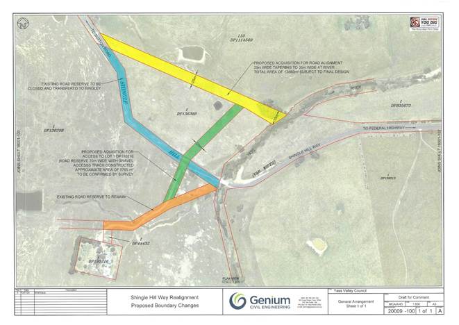
8.3 Yass Public School - Traffic Concerns
SUMMARY
To recommended an investigation and concept development process for the traffic and parking arrangements at Yass Public School be undertaken
|
That: 1. A consultant be engaged to undertake an investigation and concept development process for the traffic and parking arrangements at Yass Public School 2. The estimated consultancy cost of $30,000 be funded from reserve funds |
Financial IMPLICATIONS
The estimated cost to undertake the proposal is $30,000 which will be funded from the Contributions Reserve.
POlicy & Legislation
· Roads Act 1993
· Procurement Policy
REPORT
1. Background
For several years Council have been approached about the car parking situation at Yass Public School. Council’s Road Safety Officer, along with the Local Traffic Committee, have inspected the site numerous times to understand the school community’s main concerns.
The primary problems relate to the operation of the school including single fixed starting and finishing times and unimpeded growth of the school population with no requirement to consider associated problems (e.g. loss of onsite parking and play areas, traffic, parking etc). These issues have been raised with the Department of Education but no commitment has been received to work collaboratively on resolving the concerns.
As a result of the above, safety problems such as children interface with buses and cars has been, bus management, departure delays and the poor quality of the road access and alternate car parking opportunities at the rear of the school have been continually raised.
To help minimise safety concerns Council with support from the school and bus providers have implemented a number of measures to reduce the safety concerns including:
· The installation of a rock barricade to stop other vehicles entering the bus lane
· Dedicated teacher parking
· Safety awareness campaigns targeting parent driver behaviour
· Working alongside the bus companies and organising a ‘queue’ at the Court House where there is a clear line of sight to the school removing any traffic hazards on Laidlaw Street
· A request to have the management of the rail corridor located at the rear of the school vested to Council has been submitted which could assist with parking management
In addition Council has endeavoured to get support from TfNSW under the safety around schools program however we have been advised that this is a matter for Council.
2. Proposal
A proposal to engage an external consultant to undertake an investigation and concept development process for the traffic and parking arrangements at Yass Public School has been prepared. This proposal would involve consultation with the school, a traffic survey to understand the extent of the congestion and an intersection analysis to identify the average wait times and confirm the extent of the issues.
Once this information is gathered the consultant will investigate and identify options to address the issues and improve traffic flow in the area. A report will be prepared highlighting each identified option, cost estimates, advantages and disadvantages and a preferred option for consideration.
Potential options that have already been identified include:
· Left turn only out of school at Laidlaw Street with new roundabout at Grampian Street
· Additional parking area at O’Connor Park
· Reconfiguration of Laidlaw Street intersection e.g. roundabout, seagull intersection
· Separation of bus and passenger vehicle exits from the school
· Other options which may come out of the investigation, or discussions with the school or Council.
The estimated cost of the engaging a consultant to undertake these works is $30,000.
Key Pillar 4. Our Infrastructure
CSP Strategy IN3 - Maintain and improve road infrastructure and connectivity
Delivery Program Action IN3.1 - Deliver transport asset infrastructure, maintenance, renewal and enhancement programs for urban, rural and regional roads to maintain or improve overall condition
Operational Plan Activity IN3.1.1 - Develop and deliver annual programs for urban, rural and regional road renewal and construction, including bridges and stormwater
Ordinary Council Meeting 23 September 2020
8.4 Road Reserve Weed Spraying Trial
To advise of the ‘Priority Weeds’ spraying trial that was completed on the Council’s linear road reserve network from April to July 2020.
Approximately $53,000 was spent on the weed spraying trial from Council’s 2019/20 operational budget.
• Local Government Act 1993
• Protection of the Environment Operations Act 1997
• Roads Act 1993
• Biosecurity Act 2015
In October 2019 Council determined to undertake a cooperative targeted approach to roadside weed management. A program was developed between Council’s Environmental Services and Maintenance Management Business Units, together with adjacent property owners, to manage weeds in priority locations rather than across the whole Local Government Area.
In December 2019 a trial of road reserve priority weed spraying was undertaken. The purpose of this trial was to give guidance to Council in effectiveness of such a limited program of work and the possible required funding for an ongoing Council-wide program to assist in the management of priority weeds along Council’s road reserves.
Council’s Environmental Services Team completed an extensive inspection of the Council linear road reserve network to identify ‘Priority Weeds’ that were both existing and emerging. A series of areas within the road network were inspected and priority weeds identified.
The spraying of the road network was undertaken by two spraying contractors to ensure that the large area of linear reserve requiring spraying would be achieved within the specified trail timeframe of three months.
Weed spraying was undertaken on the following roads:
|
· Dairy Creek Road · Tallaganda Lane · Mulligans Flat Road · Glengyle Road · Old Federal Highway · Lachlan Valley Way · Burrinjuck Road · Beralston Road · Bouchers Road |
· Yass River Road · Dicks Creek Road · Whites Road · Nanima road · Yass Valley Way · Black Range Road · Burley Griffin Way · Good Hope Road · Mountain Creek Road |
· Shingle Hill Way · Gundaroo Road · Majura Creek Road · Hadlow Drive · Dog Trap Road · Wee Jasper road · Coollalie Road · Long Rail Gully Road · Clarks Road |
The predominate ‘Priority Weeds’ sprayed were:
· Serrated Tussock
· African Love Grass
· Chilean Needle Grass
The results of the program indicate a reduction in the population numbers of the above ‘Priority Weeds’ species for the roads sprayed. Follow up inspections indicated that the program has been successful in that a visible effective kill rate was achieved (>75%) of weed pest species sprayed. Further spraying will impact ‘Priority Weed’ population numbers and reduce competition for native local endemic plant species with high floristic value.
The weed spraying trial has demonstrated clearly that two spraying management cycles are required to control ‘Priority Weeds’ species within the linear road reserve. A spraying management regime is needed in both spring and autumn to control both annual and perennial weed species. Currently Council has received $80,000 through grant funding to complete a spring based spraying cycle. This will target the following weed species;
· Blackberry
· Sweet Briar
· Gorse
· Saint John’s Wort
· Scotch Thistle
It is estimated that between $100,000 - $150,000 annually is required to undertake two spraying cycles. This could be reduced significantly over several years as weed population numbers decrease requiring less spraying equating to less funding required.
Weeds management requires a cyclical annual spraying approach to ensure that Council are adequately meeting their legal requirement to manage ‘Priority Weeds’ populations within both Council managed linear road and open space reserves. This demonstrated approach reduces weed population numbers and with ongoing spraying it is anticipated that less funding will be required as less spraying is needed.
Key Pillar 4. Our Infrastructure
CSP Strategy IN3 - Maintain and improve road infrastructure and connectivity
Delivery Program Action IN3.1 - Deliver transport asset infrastructure, maintenance, renewal and enhancement programs for urban, rural and regional roads to maintain or improve overall condition
Operational Plan Activity IN3.1.2 - Develop and deliver annual maintenance programs for urban, rural and regional roads based on priority and in accordance with allocated budgets
Ordinary Council Meeting 23 September 2020
8.5 Yass & Binalong Swimming Pool Covid-19 Response
SUMMARY
To present recommendations for to the operation of Yass and Binalong swimming pools, with respect to COVID -19 public health restrictions.
It is noted that all reference to NSW Public Heath Orders contained in this report are subject to change without notice due to the continual changes relating to COVID-19.
|
That: 1. An additional amount of $69,620 be funded within the Infrastructure and Assets operational budget for both Yass and Binalong pools to deliver the procedures developed in Council’s COVID-19 Safety Plan for swimming pools, as stated in NSW Public Health Order (COVID-19 Restrictions on Gathering and Movement) Order (No 4) 2020. 2. The change rooms and shower facilities be closed at Yass and Binalong Pools as referenced in COVID‑19 Safety Plan. 3. The modifications made to Council’s swim programs be endorsed. Based on the current NSW Public Health Order Council will need to limit all sessions to 20 participants plus instructors in the dedicated lane rope sections of the pool. 4. Canteen service be restricted to pre-packaged foods and drinks. |
Financial IMPLICATIONS
To deliver the procedures developed in Council’s COVID-19 Safety Plan (as stated in NSW Public Health Order (COVID-19 Restrictions on Gathering and Movement) Order (No4) 2020.
Funding can be accommodated within Infrastructure and Assets operational budget for 2020/21.
|
2020/21 Operational budget for swimming pools |
$206,000 |
|
Proposed increase for additional staff resources |
$69,620 |
|
Revised 2020/21 Operational budget for swimming pools |
$275,620 |
POlicy & Legislation
· Public Health (Covid-19 Restrictions on Gathering & Movement) Order (No4) 2020
· COVID-19 Safety Plan Swimming Pools
REPORT
1. Background
The COVID-19 pandemic has seen the introduction of Public Health Orders to limit the community transmission of the virus. The Orders require the implementation of a COVID-19 Safety Plan for swimming pools as prescribed by NSW Health (refer Attachment A).
Measures to reduce the risk of community transmission have been developed and include:
· Physical distancing within the facility of one person per 4m2
· Swim classes have no more than 20 participants, plus instructor per class
· Swim class participants must maintain 1.5m physical distance
· Strongly encourage visitors to shower/change at home
There is no impact to pass holders, both Yass and Binalong swimming pools facilities historically do not reach capacity numbers as indicated by calculations based on the one person per 4m2, as indicated in the COVID-19 Safety Plan for swimming pools. It is noted that Yass pool reached capacity of 200 persons once during 2019/20 season on 30 January 2020.
Advisory signs will be displayed at both Yass and Binalong facilities indicating allowable numbers for each pool.
· Yass 50m pool – 194 people
· Yass Toddler pool – 32 people
· Binalong 25m pool - 55 people
· Binalong Toddler pool - 10 people
· Binalong Baby pool - 5 people
2. Operational Budget Increases (Staff Resources)
The primary objective of the lifeguard is to ensure safety of person/s while swimming. The proposed additional position/s are to accommodate actions identified through the development of the COVID-19 Safety Plan for swimming pools at both Yass and Binalong. These activities include but are not limited to:
· Cleaning schedule of touch surfaces (pool entry, front counter, canteen, toilets, seating around pool etc) to be cleaned every two hours
· Enforce social distancing within the pool and grounds - main focus on reducing crowding at canteen, entry and exit points.
· Regular COVID awareness announcements through Public Address system
· Increase frequency of water testing quality
· Customer service at canteen/front counter
3. Closure of Change Rooms and Showers
Guidelines issued by NSW Health and the COVID-19 Safety Plan for swimming pools specifies the following physical distancing requirements:
· Ensure communal facilities such as showers/change rooms and lockers have strategies in place to reduce crowding and promote physical distancing
· Where practical, stagger the use of communal facilities. Strongly encourage visitors to shower/ change at home
Due to the current layout of these facilities at both Yass and Binalong pools, it is not practical to comply with the above restrictions. The closure of these facilities is recommended. Like many sporting activities this will require patrons to attend the pool ‘swim ready’.
All toilet facilities will remain available to all patrons of both Yass and Binalong swimming pools.
4. Council Swim Classes
Council provides various swimming programs to the community. These are:
· Swimming Program – (stroke correction/competitive training):
Yass pool only - 2 sessions per day 3.30pm to 5pm and 5pm to 6.30pm for the entire pool season. Expected participants per session 70, based on 2019/20 season numbers.
Recommendation:
Based on the current NSW Public Health Order Council will need to limit all sessions to 20 participants plus teachers and instructors in the dedicated lane rope sections of the pool.
· Learn to Swim Program:
Yass pool only – held in December, one lesson per week after school for five weeks. Expected participants 12 per session, based on 2019/20 season numbers. These classes are open to all ages, however historically only younger ages attend.
Recommendation:
Based on the current NSW Public Health Order all sessions will need to limit to 20 participants plus instructors in the dedicated lane rope sections of the pool.
· Intensive Swimming Program:
Yass and Binalong pools in January, three week program, weeks 1, 2, 3 at Yass pool, week 2 Yass and Binalong pools. Expected participants 12 per session, based on 2019/20 season numbers these classes are open to all ages, however historically only younger ages attend.
Recommendation:
Based on the current NSW Public Health Order all sessions will be limited to 20 participants plus instructors in the dedicated lane rope sections of the pool.
· Aqua Aerobics:
Classes are held three times per week, day class 11am Wednesday and Friday only and evening class 6pm Tuesday only. Number of participants range from 5 to 30 based on 2019/20 season numbers.
Recommendation:
Based on the current NSW Public Health Order all sessions will be limited to 20 participants plus instructors in the dedicated lane rope sections of the pool.
· Morning Lap Swimming:
Morning lap swimming is held on Monday, Wednesday, and Friday only: 6am – 8am (subject to weather). 2019/2020 season numbers not known as a general entry is only required.
Recommendation:
Based on the current NSW Public Health Order all sessions will be limited to 20 participants in the dedicated lane sections of the pool.
Three 30 minute sessions between 6am and 8am will need to be provided to allow for a 15 minute break for cleaning in between sessions.
Participants will be required to pre – book their session for numbers control. However bookings will not be restricted and participants will be able to book for more than one session.
5. Canteen service
Based on discussions with the Department of Health food and drinks are to be restricted to pre-packaged hot foods, ice creams sweets and drinks, eliminating direct contact with food products.
Key Pillar 4. Our Infrastructure
CSP Strategy IN4 - Maintain and update existing community facilities, and support the development of new community infrastructure as needed
Delivery Program Action IN4.1 - Develop and maintain new and existing recreational and community assets to address our communities needs in a sustainable manner
Operational Plan Activity IN4.1.3 - Maintain and operate Council’s commercial assets including swimming pools and Yass Caravan Park
ATTACHMENTS: a. COVID-19 Safety Plan Swimming Pools - Saunas - Spas ⇩
b. Public Health (COVID-19 Restrictions on Gathering and Movement Order (No 4) 2020 ⇩
8.5 Yass & Binalong Swimming Pool Covid-19 Response
Attachment a COVID-19 Safety Plan Swimming Pools - Saunas - Spas
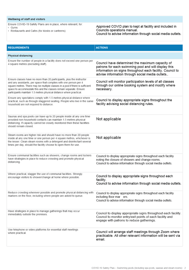
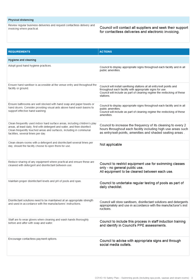

Attachment b Public Health (COVID-19 Restrictions on Gathering and Movement Order (No 4) 2020


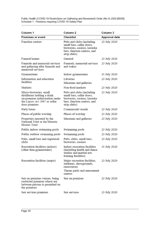
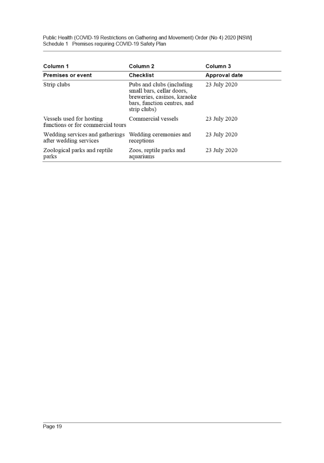
8.6 Draft 2020 Stategic Plan Murrumbateman Recreation Grounds
To advise of the process to update the 2017 Strategic Plan Murrumbateman Recreation Grounds. To ensure community participation in the development of the site and fast track current capital work improvements.
The current 2020/21 Operational plan includes budget to complete:
1. New amenities building
2. Sand arena stabilisation.
3. Enclosed dog park
· Local Government Act 2993
· 2017 Strategic Plan Murrumbateman Recreation Grounds
Council had made an undertaking to consult with the community regarding updating the 2017 Strategic Plan Murrumbateman Recreation Grounds in early 2020. Unfortunately planned community workshops were cancelled due to COVID-19 restriction.
A Councillor Workshop was held on 31 August 2020 to develop a revised strategic plan prior to community engagement. Councillors and staff had a collaborative discussion, worked through site issues, site constraints and ideas received from user groups. These have been formulated into concepts within the draft strategic plan (refer Attachment A).
The main features that were resolved by the workshop and incorporated into a new strategic plan for community consultation are;
· The development of an equestrian precinct which formalises a storage and clubhouse into one facility
· The site for horse yards and associated infrastructure
· New amenities building location
· Location of future community hall
· All purpose hardcourts for multiple sports i.e. tennis, basketball and netball
· Upgrade of site entrance from Barton Highway
· Development of an enclosed dog park facility within the southern sand arena
· Pathways and roadway linkages within the site
· Oval irrigation and water storage tank
· Signs as remote supervision
Council currently has funding within the 2020/21 financial year capital works budget to undertake the following:
· Murrumbateman sand arena stabilisation
· Murrumbateman Recreation Ground dog park
· Murrumbateman Recreation Ground amenities
Council has also undertaken grant submissions to seek funding to complete the following projects:
· Storage/club house facilities for equestrian and other user groups
· Horse yards and formalised roadway within the Equestrian Precinct
A new strategic plan will identify infrastructure for existing and new activities. It is important to acknowledge that whilst the consultation with the community and users is currently being completed approved capital improvements will commence. These are:
· Preliminary work activities for the new amenities building
· Design for the new enclosed dog park
· Working construction drawings for the future community hall (shovel ready for grant funding opportunities)
· Investigation of sand arena stabilisation for equestrian groups
The draft 2020 Strategic Plan Murrumbateman Recreation Grounds is suitable for public exhibition, user group consultation and wider community comment. If there are no significant submissions received it is recommended that the document be adopted after the exhibition period.
Key Pillar 4. Our Infrastructure
CSP Strategy IN4 - Maintain and update existing community facilities, and support the development of new community infrastructure as needed
Delivery Program Action IN4.1 - Develop and maintain new and existing recreational and community assets to address our communities needs in a sustainable manner
Operational Plan Activity IN4.1.1 - Develop and maintain sports grounds and associated facilities to standard that enables use by a variety of users
ATTACHMENTS: a. Draft 2020 Strategic Plan Murrumbateman Recreation Grounds ⇩
8.6 Draft 2020 Stategic Plan Murrumbateman Recreation Grounds
Attachment a Draft 2020 Strategic Plan Murrumbateman Recreation Grounds

![]()
![]()
Table of Contents
1. INTRODUCTION
2. BACKGROUND
3. AIMS AND OBJECTIVES
4. CURRENT FACILITY PURPOSES
5. CONSULTATION
6. STRATEGIC PLAN
7. MANAGEMENT ZONES
8. PLAN OF MANAGEMENT PROGRAM
9. PROPOSED ACTIONS
10. ACTION PLAN
Murrumbateman Recreation Ground is a multi-use facility located along the Barton Highway within the main township of Murrumbateman. The facility is approximately 45 hectares in size and includes an equestrian precinct, sporting field, tennis courts, playground, community hall, amenities building, public toilets and passive open space areas.
The purpose of this strategic plan is to provide Yass Valley Council and the community with a direction for structured development of the Murrumbateman Recreation Ground as well as meeting the legislative requirements of the Local Government Act 1993.
The objectives of this strategic plan is to identify the current uses of the area and outline the long term direction of the development of the recreation grounds.
Yass Valley Council has 10 sporting facilities, which are well distributed throughout the municipal area providing a range of varying sporting activities.
In 2017 Council developed an upgrade program based off consultation with sporting user groups for existing assets located at sporting facilities in the Yass Valley LGA. This program supports the significant increase of participants in sports and provides an opportunity to introduce new sporting codes to the LGA. This program also aligns with the renewal program identified in Council’s Asset Management Plan.
The heavy use of sporting grounds by multiple user groups has considerably increased in the past three years which has caused Council to review the demands placed on the individual sporting venues.
It is important to ensure that Council’s facilities are well managed, maintained and meets the growing needs and expectations of both residents and visitors to Yass Valley. Council has committed to the ongoing maintenance, enhancement and redevelopment of sporting facilities within the Yass Valley, and this is assisted through this strategic plan.
3. AIMS AND OBJECTIVES
The aims and objectives of the strategic plan are:
· To provide quality sporting and recreational space for the community.
· To provide a management approach that delineates and integrates activities within the site and surrounding recreational areas that will identify the various elements.
· To provide a proposed program for the development of the site to a regional or national sporting level.
· Identify the need to develop a Plan of Management that will meet legislative requirements and be a supporting document for any grant funding applications.
· To enhance the aesthetics for the natural environment of the Murrumbateman Recreation Ground.
4. CURRENT FACILITY PURPOSES
Murrumbateman Recreation Ground is a facility that is utilised for active and passive recreation. The local activities undertaken include:
|
· Tennis · Cricket · Equestrian activities · Scouts · Dog Shows · Dancing · Karate · Community Events |
· Men’s Shed · Yoga · Mothers & children playgroups · Village Markets · Film evenings · Christmas Carols · Wine shows · Field Days |
The Murrumbateman Recreation Ground has recently been developed with new an equestrian facility which removes equestrian activities from the main sporting oval. Council is undertaking works to the main oval to bring the surface up to a suitable playing standard. These upgrades will create an opportunity for sporting events to commence such as:
· AFL
· Soccer
· Rugby League
· Little Athletics
The recreation grounds has a designated passive recreation area known as Jones Park which includes a category 3 playground and significant open space area. Service levels for this park aligns with Council’s adopted 2017 Parks and Playground Strategy.
5. CONSULTATION
Yass Valley Council will use in its methodology for consultation a holistic approach to each facility including both internal and external stakeholders to understand and develop the assets required through the strategic direction in which Murrumbateman Recreation Ground needs to move towards to create more sporting opportunities for the community.
Council has previously worked extensively within the community and with local sporting bodies to gain an understanding of the future requirements for the Murrumbateman Recreation Grounds which is reflected in the actions list in this strategic plan.
Sporting and Active Zones
This zone provides an area which can be utilised for both sporting and active recreation. The site includes a playing field, multiple equestrian arenas and open space for equestrian activities.
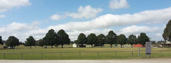
Figure 3 –playing field
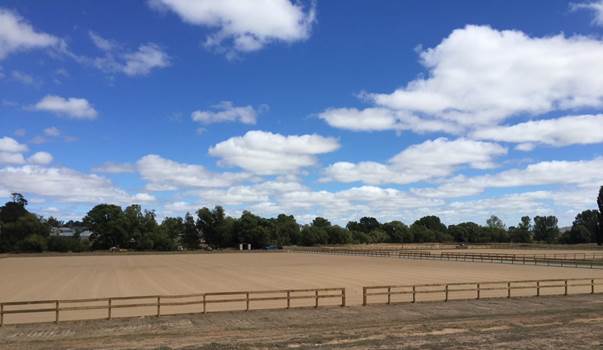
Figure 4 – equestrian arenas
Passive Recreation Zones
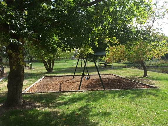
Figure 5- Jones Park
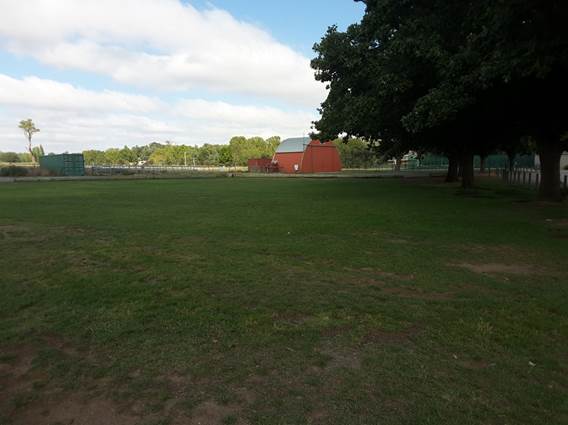
Figure 6- Passive open space area
8. PLAN OF MANAGEMENT PROGRAM
Under Section 36 of the Local Government Act 1993, Council must prepare Plans of Management for community land.
All Council owned sporting facilities will be incorporated in a generic Plan of Management. This will provide management actions that relate to all sporting facilities and will comprise the following:
· A plan of management for community land must identify the category of the land
· A current description of the natural and cultural resources.
· Planning considerations relevant to the land.
· A statement of the long term objectives for the reserve and the associated management targets for the specified period.
· Method of assessment of organized objectives and targets.
· The condition of the land, and of any buildings or other improvements on the land, as at the date of adoption of the plan of management.
9. PROPOSED ACTIONS
It is important to develop Murrumbateman Recreation Ground in a sequential and detailed approach. This allows the various tasks to be identified, resourced and programmed as appropriate. Projects can be considered annually by Council for consideration in its yearly operational plan and also identified for grant funding where applicable.
The proposed actions as outlined hereunder will provide the guidelines for the enhancement and development of Murrumbateman Recreation Ground and its immediate surrounds.
|
Item |
Activity |
|
1 |
Construct new Community Hall |
|
2 |
Investigate power upgrade to recreation grounds |
|
3 |
Relocate internal fencing to increase parking around sporting oval |
|
4 |
Formalise wash bay / car parking – equestrian precinct |
|
5 |
Construct new Amenities Building |
|
6 |
Installation of irrigation to sporting oval |
|
7 |
Installation of 120,000L Water Tank |
|
8 |
Construct new Multipurpose Courts |
|
9 |
Construct new Netball Courts |
|
10 |
Cricket net – adjust entry point into nets to the south side |
|
11 |
Construct new storage facility – sporting groups |
|
12 |
Install directional signs for equestrian facilities |
|
13 |
Construct new Dog Park |
|
14 |
Install new swings at Jones Park |
|
15 |
Construct improvements to Barton Highway entrance into recreation ground |
|
16 |
Construct new storage facility/clubhouse – equestrian precinct |
|
17 |
Construct linked pathway to dog park / winery trail |
|
18 |
Upgrade existing public toilets |
|
19 |
Upgrade internal roadway to equestrian precinct |
NB: priorities and funding will be subject to consideration annually by Council in its Operational Plan Process.
9.1 Investment and Borrowings Report
SUMMARY
In accordance with the Clause 212 Local Government (General) Regulation 2005, this report provides a summary of Council’s investments as at 31 July 2020. In accordance with paragraph (1)(b), it can be certified that the investments listed have been made in accordance with the Act, the Regulations and Council’s Investment Policy.
|
The Investment Report as at 31 August 2020 be received and it be noted that the summary has been prepared in accordance with the Act, the Regulations and Council’s Investment Policy.
|
Financial IMPLICATIONS
Council’s investment portfolio provides funding for some projects identified in the Operational Plan.
POlicy & Legislation
· s625 Local Government Act 1993
· Clause 212 Local Government (General) Regulation 2005
· Investment Policy
REPORT
Comments on Economic Climate
The RBA has kept the official cash rate at 0.25% and released updated forecasts for the Australian economy. The Australian economy is experiencing the biggest contraction since the 1930’s. Arguing that while the initial decline in activity appears to be smaller than initially feared, the recovery will also be slower than anticipated. The major uncertainty looming over the outlook remains whether governments can contain the spread of COVID-19 and the level of restrictions that remain in place.
Council Investments
Valuations of Council investments are detailed in Attachment A.
Due to the uncertainty around the potential impacts of COVID-19, Council is currently holding a higher than usual balance in its ‘At Call’ accounts.
Council Loans
Council has five loans with balance owing as at 30 June 2020 of $16.782m. The table below provides loan details as at 30 June 2020. Indicative repayments for 2020/21 are shown for both principal and interest for all current loans. Balances will not change on a monthly basis as the most frequent repayment cycle is quarterly.
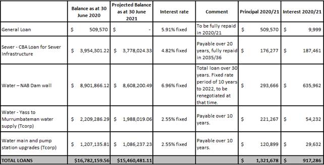
Key Pillar 5. Our Civic Leadership
CSP Strategy CL1 - Effect resourceful and respectful leadership and attentive representation of the community
Delivery Program Action CL1.6 - Maximise Council’s ability to generate income
Operational Plan Activity CL1.6.3 - Review commercial activities to ensure Council is maximising returns
ATTACHMENTS: a. August 2020 - Investments ⇩
Ordinary Council Meeting 23 September 2020
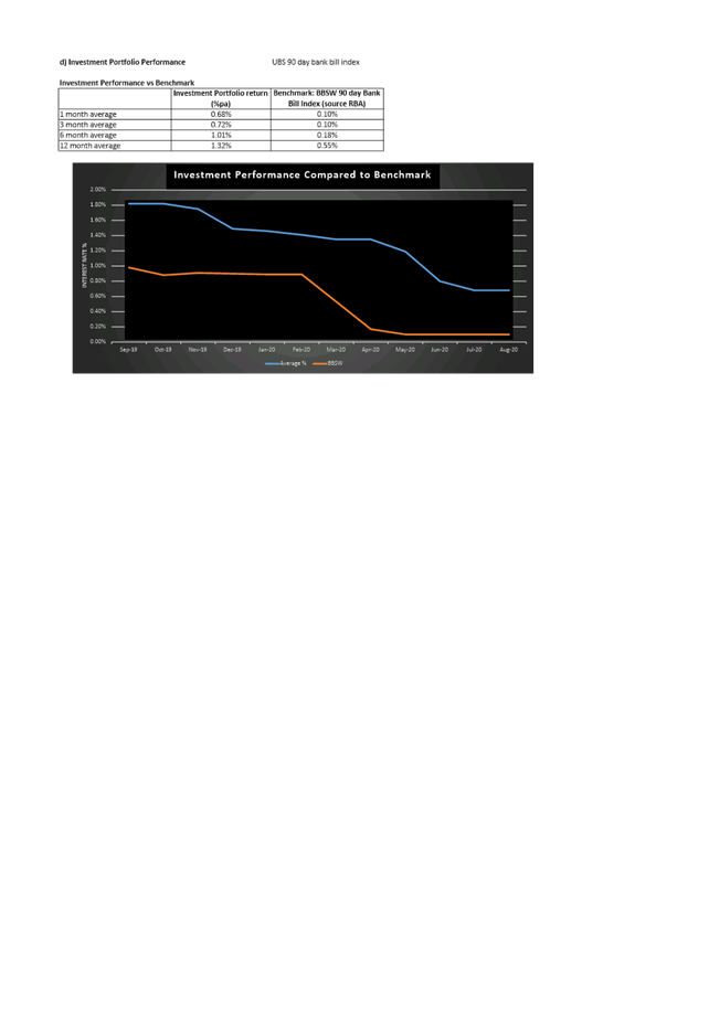
10.3 Application for Financial Hardship
To consider an application seeking a rebate for water usage under the Financial Hardship Policy.
Reduction in income.
· Financial Hardship Policy
In May 2020 Council adopted a Financial Hardship Policy. Council are required to make a determination in respect of all hardship applications received. An application seeking a rebate for water usage has been received. As it deals with the personal hardship of a resident the matter needs to be considered in closed session.
Key Pillar 5. Our Civic Leadership
CSP Strategy CL2 - Encourage and facilitate open and respectful communication between the community, the private sector, Council, and other government agencies
Delivery Program Action CL2.1 - Make doing business with Council easier
Operational Plan Activity CL2.1.1 - Continued development of Council's online presence that improves customer experiences