Ordinary Meeting of Council
Wednesday 17 December 2014
4:30pm
Council Chambers
209 Comur Street, Yass
Ordinary Meeting of Council
Wednesday 17 December 2014
4:30pm
Council Chambers
209 Comur Street, Yass
|
PRAYER:
All Stand:
Mayor: Let us be still and remember the presence of God. As we commence our meeting let us together pray for guidance and help.
All say together:
Almighty God, we ask your blessing upon this Council.
Direct and prosper our deliberations to the true welfare of Australia and the people of Yass Valley Amen.
|
FUTURE MEETINGS
|
February 2015 Wednesday 4th 4:30pm Special Planning Meeting
Wednesday 25th 4:30pm Ordinary Meeting of Council
|
Ordinary Meeting of Council
Open Forum Page No.
(i) Austin Goodfellow (tentative) – Item 8.1 Gundaroo Groundwater
(ii) Brendan Price – Item 8.4 Asbestos Issues - Hume Park and Allen Park
1. Prayer
2. Apologies
3. Declaration of Pecuniary Interests/Special Disclosures
4. Confirmation of Minutes
Minutes of Ordinary Council Meeting held on 26 November 2014........................................................... 5
5. Business Arising from Minutes
6. Minutes and Recommendations of Council Committees
6.1 Draft Minutes of the Murrumbateman Recreation Reserve Grounds Committee Meeting held on 25 November 2014........................................................................................................................................................ 28
8. Director of Planning Reports
8.1 Gundaroo Groundwater ........................................................................................................................................ 31
8.2 Parkwood Planning Proposal - Gateway.......................................................................................................... 36
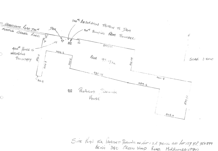
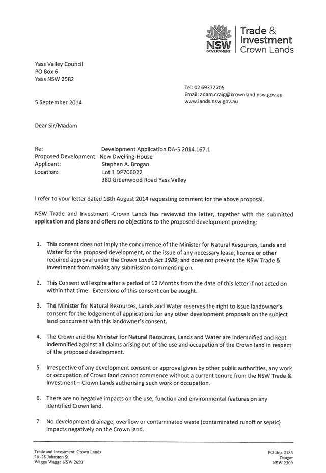
8.3 Development Applicaton No 5.2014.177.1 - Dwelling House, 380 Greenwood Road, Yass River... 54
8.4 Asbestos Issues - Hume Park and Allen Park.................................................................................................. 83
8.5 Draft Policy: Consolidation of Lots...................................................................................................................... 88
8.6 Enforcement Policy................................................................................................................................................. 101
9. Director of Engineering Reports
9.1 Playground Strategy 2014.................................................................................................................................... 125
9.2 Minutes Statutory, Regional and Council Supported Committees......................................................... 147
9.3 Regional Waste Strategies................................................................................................................................... 150
9.4 Works Section Structure....................................................................................................................................... 153
9.5 Water Supply Policy............................................................................................................................................... 157
9.6 Yass Dam Riparian Revegetation Contract YVC/ASS/07.2014 ................................................................. 165
10. Director of Corporate & Community Reports
10.1 Fees and Charges Waived Under Delegation................................................................................................ 167
10.2 Investment Report.................................................................................................................................................. 168
10.3 Model Code of Conduct Complaint Statistics 2013/14................................................................................ 171
11.1 Local Government Reform - Fit for the Future.............................................................................................. 172
11.2 Yass Business and Cultural Precinct.................................................................................................................. 176
12.1 Strategy to Reduce Council Operating Costs................................................................................................ 179
Close of Meeting Time
D.J. Rowe
GENERAL MANAGER
Minutes of the
Ordinary Meeting of Council
Wednesday 26 November 2014
4:30pm
Council Chambers
209 Comur Street, Yass
Table of Contents
1. Prayer
2. Apologies
3. Declaration of Interest/Disclosures
4. Confirmation of Minutes
5. Business arising from Minutes of Ordinary Meeting
6. Minutes and Recommendations of Council Committees
6.1 Draft Minutes of the Sutton Hall Committee held on 14 October 2014
6.2 Draft Minutes of the Wee Jasper Community Association held on 1 November 2014
6.3 Draft Minutes of the Finance and Governance Committee held on 11 November
6.4 Minutes of the Southern Slopes Noxious Weeds Authority held on 21 August 2014
7. Mayoral Minute
8. Director of Planning Reports
8.1 Rural Lands Planning Proposal Update
8.2 Development Consent 5.2014.68.1 - Rural Subdivision, 452 Fifeshire Road, Good Hope
9.6 Strategic Business Plan for Water & Sewerage
8.3 Development Application No 5.2014.133.1 - Child Care Centre, 116 Rossi Street, Yass
8.4 Hadlow Drive, Sutton - Development Compliance Issues
8.5 Home Business/Home Occupation Enforcement Procedure
8.6 Town Centre Parking Enforcement
9. Director of Engineering Reports
9.1 Yass Tramway Cycleway link
9.2 Update on Yass Park and Ride Facility
9.3 Condition Assessment of Council's Timber Road Bridges
9.4 Hovell Street Land Acquisition
9.5 Road Standards Policy - RD-POL-9
10. Director of Corporate & Community Reports
10.1 Operational Plan Progress Report to 30 September 2014
10.2 Investment Report
10.3 Legal Services Panel
10.4 1st Quarterly Financial Budget Review
11. General Manager Reports
11.1 Resolution for 2016 Local Government Elections
11.2 Minutes Statutory, Regional & Council Supported Committees 21
11.3 High Speed Rail
12. Notice of Motion
13. Questions with Notice
14. Confidential Matters
Present
Councillors Rowena Abbey, Mayor, in the chair, Cecil Burgess, Greg Butler, Ann Daniel, Geoff Frost, Michael McManus, David Needham and Garry Ware.
Also present were the General Manager – David Rowe, Director of Planning & Environmental Services – Chris Berry, Director of Operations – Simon Cassidy, Director of Corporate & Community Services – Sheri Norton and Corporate Planning and Executive Support Officer – Shirree Garland.
Open Forum
Presentation of Australian Citizenship Certificates
The Mayor conducted a citizenship presentation ceremony and congratulated the following people on becoming Australian Citizens: Mr Mark Gatt, Mrs Elsie Pieterse and Mr Renier Pieterse.
Presentation – Asbestos Issues
The Mayor welcomed Mr Terry Apps to the meeting and invited him to address Council. Mr Apps raised concerns about asbestos and when it would be cleared from the property, Allan Park on the Hume Highway near Bowning.
At the conclusion of the presentation the Mayor thanked Mr Apps for his attendance and presentation to Council.
Presentation – Asbestos Issues
The Mayor welcomed Mr Brendan Price to the meeting and invited him to address Council. Mr Price raised concerns about asbestos which may have been illegally disposed of at Hume Park.
At the conclusion of the presentation the Mayor thanked Mr Price for his attendance and presentation to Council.
Presentation – Auditors
The Mayor welcomed Ms Clare Wagner to the meeting and invited her to address Council. Ms Wagner provided comments in relation to investments, revenue, expenses and cash flows and answered questions from Councillors.
At the conclusion of the presentation the Mayor thanked Ms Wagner for her attendance and presentation to Council.
The meeting opened at 5.20 pm.
1. Prayer
2. Apologies
Councillor Jones was granted leave of absence for the 26 November 2014 Council Meeting at the meeting held on 30 April 2014 - Minute No. 78.
3. Declaration of Interest/Disclosures
Councillors Rowena Abbey, Cecil Burgess and Ann Daniel declared Special Disclosure of Pecuniary Interests in Item 8.1 – Rural Lands Planning Proposal Update.
Councillor Rowena Abbey declared a Non-Significant, Non Pecuniary Interest in Item 8.2 – Development Consent 5.2014.68.1 and a Pecuniary Interest in Item 9.6 – Strategic Business Plan for Water & Sewerage.
4. Confirmation of Minutes
|
RESOLVED that the minutes of the Ordinary Council Meeting held on 22 October 2014 covered by page numbers 1 - 15 inclusive and resolution numbers 243 - 268 inclusive, copies of which had been circulated to all Councillors, be taken as read and confirmed. (Ware/McManus) 269 |
5. Business arising from Minutes of Ordinary Meeting
Nil
6. Minutes and Recommendations of Council Committees
|
6.1 Draft Minutes of the Sutton Hall Committee held on 14 October 2014 FILE: C.02.04.04 - CC |
|
SYNOPSIS To provide Council with the draft minutes of the Sutton Hall Committee meeting held on 14 October 2014. The following recommendations are presented for Council’s consideration and adoption.
|
|
RESOLVED that Council receive the draft Committee Minutes of the Sutton Hall Committee meeting held on 14 October 2014. (Needham/Burgess) 270 |
|
6.2 Draft Minutes of the Wee Jasper Community Association held on 1 November 2014 FILE: C.02.04.06 - CC |
|
SYNOPSIS To provide Council with the draft minutes of the Wee Jasper Community Association held on 1 November 2014. The following recommendations are presented for Council’s consideration and adoption. |
|
RESOLVED that Council receive the draft Committee Minutes of the Wee Jasper Community Association meeting held on 1 November 2014. (Frost/Ware) 271 |
|
6.3 Draft Minutes of the Finance and Governance Committee held on 11 November FILE: C.02.00.03 - SN |
|
SYNOPSIS To provide Council with the draft minutes of the Finance and Governance Committee held on 11 November in the Council Chambers. The following recommendations are presented for Council’s consideration and adoption.
|
|
|
|
RESOLVED that Council receive the draft Committee Minutes of the Finance and Governance Committee meeting held on 11 November 2014 and adopt the following recommendations:
1. That the Quarterly Budget Review Statement for the period ending 30 September 2014 with a deficit of ($585,301) be recommended to Council; 2. It is noted that in accordance with the Local Government (General) Regulation (NSW) Section 203(2)(a), Council’s financial position as at 30 September 2014 is satisfactory, having regard to revised projected estimates of income and expenditure, and the original budgeted income and expenditure. (Needham/McManus) 272 |
|
6.4 Minutes of the Southern Slopes Noxious Weeds Authority held on 21 August 2014 FILE: FL.C.02.05.06 - CB |
|
SYNOPSIS To provide Council with the minutes of the Southern Slopes Noxious Weeds Authority held on 21 August 2014 in Boorowa. From these minutes there are no items which cover matters that:
· Requires expenditure not provided for in the current Operational Plan · Involve a variation to a Council Policy · Are contrary to a previous decision or position of Council · Relate to a matter which requires Council to form a view or adopt a position · Deal with matter of specific interest
|
|
RESOLVED that Council receive the Minutes of the Southern Slopes Noxious Weeds Authority meeting held on 21 August 2014. (Burgess/Ware) 273 |
7. Mayoral Minute
8. Director of Planning Reports
|
8.1 Rural Lands Planning Proposal Update FILE: PP-2012-01 - LM |
|
At 05:32 PM Councillors Burgess, Abbey and Daniel left the Chambers. Councillor Michael McManus, Deputy Mayor took the Chair. |
|
SYNOPSIS To advise of the outcome of discussions with the NSW Office of Environment & Heritage, and the Department of Primary Industries – Agriculture in relation to the Rural Lands Planning Proposal.
|
|
RESOLVED that - 1. Support for a 40 ha minimum lot size with averaging provisions across all RU1 and RU2 zoned land within the Yass Valley Local Government Area continue to be reaffirmed; 2. The retention of a 80 ha minimum lot size within parts of the LGA is not supported; 3. Copies of all community submissions received during public exhibition be forwarded to the Department of Planning & Environment; 4. That the Deputy Mayor write to the Minister for Planning and Primary Industries and copied to the Premier and Deputy Premier to express extreme disappointment of Yass Valley Council and the Yass Valley people that through their Departments they have been unwilling to resolve this issue in favour of the Yass community in accordance with the well-researched and transparently produced Rural Lands proposal. (Needham/Frost) 274 |
FOR: Councillors G Butler, G Frost, M McManus, D Needham and G Ware
AGAINST: Nil
INTEREST: Councillors Councillor Abbey, Councillor Burgess and Councillor Daniel
ABSENT: Councillor Jones
At 05:53 PM Councillors Burgess and Daniel returned to the Chambers.
|
8.2 Development Consent 5.2014.68.1 - Rural Subdivision, 452 Fifeshire Road, Good Hope FILE: 2450 - KM |
|
|
|
SYNOPSIS An application has been received to modify Development Consent 5.2014.68.1 for a four lot rural subdivision of 452 Fifeshire Road, Good Hope. The proposed modification is seeking to vary Council’s policy on the Provision of Power Supply and Telephone Services in Rural Subdivisions.
|
|
RESOLVED that - 1. Development Consent No 5.2014.68.1 for a four lot rural subdivision of 452 Fifeshire Road, Good Hope be modified under delegations; 2. Work be undertaken on Fifeshire Road after the $20,000 contributions have been received. (Frost/Burgess) 275
|
FOR: Councillors C Burgess, G Butler, A Daniel, G Frost, M McManus, D Needham and G Ware
AGAINST: Nil
INTEREST: Councillor Abbey
ABSENT: Councillor Jones
|
Motion
|
|
RESOLVED that Item 9.6 – Strategic Business Plan for Water & Sewerage be dealt with. (Ware/Frost) 276 |
|
9.6 Strategic Business Plan for Water & Sewerage FILE: W.02.01.00 - SC |
|
SYNOPSIS Council’s current strategic business plan for water supply and sewerage was adopted in 2006. This plan has now been revised to incorporate Council’s current financial position and reflect Council and community aspirations for water and sewerage infrastructure. The plan identifies that the required infrastructure and services can be provided sustainably and identifies when specific projects are planned to be completed. The plan also models the required level of typical residential bill (rates) to achieve the identified works. This shows a reduction in current water rates once Council’s current debt for the Yass Dam project is reduced, and a small increase in sewerage rates to cover the costs of the various new and upgraded infrastructure required to be provided.
|
|
RESOLVED that the Strategic Business Plan for Water and Sewerage Services 2014 be adopted by Council. (Frost/Butler) 277 |
At 06:04 PM Councillor Abbey returned to the Chambers.
|
8.3 Development Application No 5.2014.133.1 - Child Care Centre, 116 Rossi Street, Yass FILE: 1297.B - MR |
|
SYNOPSIS To consider Development Application No 5.2014.133.1 for a Child Care Centre at 116 Rossi Street, Yass. The proposal has received three submissions and involves variations to Council Policy.
|
|
RESOLVED that conditional Development Consent be issued under delegation for Development Application No 5.2014.133.1 for a Child Care Centre at 116 Rossi Street, Yass. (Frost/Ware) 278 |
FOR: Councillors R Abbey, C Burgess, G Butler, A Daniel, G Frost, M McManus, D Needham and G Ware
AGAINST: Nil
ABSENT: Councillor Jones
|
8.4 Hadlow Drive, Sutton - Development Compliance Issues FILE: PR007054 - CB |
|
SYNOPSIS To provide a status report on action taken in relation to development compliance issues for several properties in the Hadlow Drive area of Sutton.
|
|
RESOLVED that - 1. The progress report on development compliance issues in Hadlow Drive, Sutton be noted; 2. The Draft Enforcement Policy be brought back to the December meeting with the Complaints Policy. (Needham/Burgess) 279 |
|
8.5 Home Business/Home Occupation Enforcement Procedure FILE: 1104 - CB |
|
SYNOPSIS To present a draft procedure in relation to operating a business from a residential property. |
|
RESOLVED that the Home Business/Home Occupation Enforcement Procedure be endorsed with the inclusion of feedback being provided to the complainant. (Ware/McManus) 280 |
|
8.6 Town Centre Parking Enforcement FILE: FL.R.05.06.03 - CB |
|
SYNOPSIS To outline the approach to town centre parking enforcement. |
|
RESOLVED that the broad approach to town centre parking patrols be endorsed. (Ware/McManus) 281 |
9. Director of Engineering Reports
|
9.1 Yass Tramway Cycleway link FILE: R.01.00.00 - SC |
|
SYNOPSIS Council has previously supported the concept of constructing a cycleway along the route of the old tramline parallel to Laidlaw Street. A submission was recently provided to Transport for NSW detailing this concept and funding opportunities are currently available through the NSW government active transport program. For the project to proceed Council needs to obtain community support and also gain approval from the Minister to have the tramlines removed or covered to allow the construction of a cycleway. It is proposed that community engagement be commenced and that an application for funding to develop a concept design also be submitted. |
|
RESOLVED that - 1. Council support the proposal for a future cycleway along the old tramway corridor and that an application be submitted under the NSW government active transport program; 2. A community engagement plan be developed and community engagement on the proposed cycleway be commenced. (Butler/Ware) 282 |
|
9.2 Update on Yass Park and Ride Facility FILE: B.08.00.00 - TC |
|
SYNOPSIS Following completion of the Park & Ride Options Study, Council has successful received a $330,000 grant from Transport for NSW to construct the park and ride bus facility in Lead Street Yass. In preparation to undertake this project a review of the drainage infrastructure adjacent to the site indicates that an open drain is currently unstable and it is proposed that this issue be addressed as part of the park and ride project.
|
|
RESOLVED that - 1. Council note the receipt of $330,000 grant from Transport for NSW for the construction of a Park and Ride facility in Lead Street Yass; 2. The upgrade of the open drain adjacent to the park and ride facility be undertaken concurrently with the Park and Ride facility construction; 3. The Ford Street (Yass River to Grampian St) stormwater drainage project be deferred and considered as part of the draft 2015/16 Operational Plan and the $100,000 budget be utilised to fund work from Recommendation 2 above. (Frost/Daniel) 283 |
|
9.3 Condition Assessment of Council's Timber Road Bridges FILE: R.05.06.01 - TC |
|
SYNOPSIS To provide an update to Council on a review undertaken of Council’s timber road bridges and the potential need to implement load limits.
|
|
RESOLVED that -
1. Letters be prepared and sent to property owners that are directly impacted by the potential bridge load limits;
2. A further report be prepared to Council to provide details of any proposed load limits and actions to remove or ameliorate the effects of the load limits. Such options could include bypasses, low level crossings, bridge shoring, component replacement, bridge replacement etc.;
3. A 5 tonne bridge load limit be placed on Walmsleys Bridge, Yass River Road as a matter of urgency;
4. Further community engagement be undertaken once final results of bridge assessments are known. (McManus/Ware) 284 |
|
9.4 Hovell Street Land Acquisition FILE: R.05.01.00 - SC |
|
SYNOPSIS As a result of two separate development applications, discussions were held with two property owners about the potential for Council to acquire land on Hovell Street as “Road Widening” to improve the ability to construct a future cycleway at a reasonable gradient. Negotiations have taken place and Council now needs to consider the acquisition of the land.
|
|
RESOLVED that - 1. Council agree to the acquisition from Watt of Part Lot 3 DP 817640 and Part Lot 35 DP 872665 for $6,528;
2. Council agree to the acquisition from Marshall of part Lot 2 DP 817640 and Part Lot 101 DP 1106965 for $32,750.
(McManus/Ware) 285 |
|
9.5 Road Standards Policy - RD-POL-9 FILE: P.05.00.00 - SC |
|
SYNOPSIS Councils Road Standards Policy RD-POL-9 has been amended in response to recent Council decisions and also to clarify a number of issues and correct some typographical errors. The revised policy has been placed on public exhibition and no submissions were received. The policy is now being presented to Council for adoption.
|
|
RESOLVED that revised policy RD-POL-9 – Road Standards, be adopted by Council with the following amendment: “13. Village Laneways (2nd paragraph) Subdivision will not normally be permitted where the primary access to any lot is proposed from a Laneway. Any proposed dwelling or dual occupancy on an existing lot must also be accessed from the Council road network and not via a Laneway.” (Needham/McManus) 286 |
|
Title: |
ROAD STANDARDS POLICY RD-POL-9 |
Service: ROADS
Responsible Officer: ENGINEERING SERVICES MANAGER
1. OBJECTIVES
To provide guidelines for minimum design standards of roads, private accesses and car parking facilities.
To provide guidelines to be used in assessment of development applications.
2. DEFINITIONS
|
Dwelling - |
“A room or suite of rooms occupied or used or so constructed or adapted as to be capable of being occupied or used as a separate domicile”.
|
|
Dwelling House - |
“A building containing one but not more than one dwelling”.
|
|
Dual Occupancy - |
“A building or group of buildings on one allotment of land containing two dwellings”.
|
|
Existing Parcel - |
As defined in Council’s Environmental Planning Instruments.
|
|
Regional Roads |
Sutton Rd, Gundaroo Rd, Murrumbateman Rd, Yass Valley Way, Burrinjuck Rd, and Wee Jasper Rd. |
3. RIGHT OF CARRIAGEWAY (ROW) ACCESS
3.1 RoW’s will not be permitted where subdivision to create new allotments with an entitlement to erect a dwelling house(s) is proposed, irrespective of the type of access arrangements currently servicing the land.
3.2 RoW’s will only be considered to allow access from a road maintained by a public authority to a proposed dwelling house on an allotment where that allotment is either:
3.2.1 a vacant “existing parcel” or “land with a dwelling entitlement” currently accessed by a ‘ROW’;
OR
3.2.2 a vacant allotment lawfully created by subdivision for the purpose of a dwelling house under a previous planning instrument of Council which may be currently accessed by an existing right of way.
3.3 Exiting RoW’s that are considered to be trafficable and provide a safe all weather access will not require upgrading.
3.4 Existing RoW’s (or part thereof) that are considered substandard in relation to safety or accessibility, will require upgrading to the minimum standard specified in Clause 3.5.
3.5 Minimum requirements for construction of RoW’s shall be as follows:
Table 1.0. – RoW and Battleaxe Handle Characteristics
|
Land Zoning |
Min. Dedicated Width (m) |
Pavement Width (m) |
Min. Pavement Depth (mm) |
Drainage Design l in .... Years |
|
Rural and Rural Residential |
10 |
4.5 |
150 |
5 |
|
Urban Note 3, Note 4 |
5.0 |
4.5 |
100 |
5 |
1 Any RoW in an urban or rural-residential environment shall be constructed as follows:
Minimum of 50mm thick gravel base and 100mm thick concrete layer (25 MPA with SL72 mesh), or similar approved all weather pavement.
2 The maximum length of a RoW in an urban area shall be 50m.
3.6 Maintenance of RoW’s is the responsibility of the beneficiaries.
4. BATTLE-AXE HANDLE ACCESS
4.1 Battle-axe allotments will only be approved in exceptional circumstances where it can be demonstrated that the proposed layout supports the planning, heritage and environmental objectives of the area.
4.2 Adjoining battle-axe handle accesses are permitted to a maximum of two adjoining allotments only in an urban area where a shared access is provided and a reciprocal right of carriageway is created over the access.
4.3 The maximum length of a battle-axe handle is 50m in urban areas.
4.4 Construction standards for battle axe handles shall be in accordance with table 1.0.
5. URBAN PROPERTY ACCESS
5.1 All property entrances accessing an urban road or village street shall be constructed to the following minimum specifications from the road pavement to the property boundary:
· Safe Sight Distance Requirements in accordance with Section 7 of this policy;
· A Minimum of 3.0 metres wide with maximum trafficable width of 5.0 metres wide at the kerb or road edge where no kerb exists.
· Minimum of 50mm thick gravel base and 100mm thick concrete layer (25 MPA with SL72 mesh), or similar approved all weather pavement.
· Cut and fill batters within the road verge shall be graded to a maximum of 1 in 8.
· Driveways are to be constructed at least 6m from the tangent point of the kerb at any intersection.
· The grade of the driveway from the kerb or edge of seal to the property boundary shall be +2.5% (ie. 2.5% sloping upwards from the kerb to the property boundary).
· The maximum allowable longitudinal change in grade of any driveway shall be 12%.
NB: Where the above requirements are not practical due to site constraints, alternative proposals may be considered by the Director of Operations.
5.2 Property accesses for corner blocks shall be located on the street with the lowest traffic volumes wherever practical. In Village areas access to the road with higher traffic may be permitted where the lower trafficked road is unsealed or unformed.
5.3 Driveways should generally be located 1.5 - 2 metres from the southern or western boundary of the block as appropriate. This will ensure any future residence on the block is able to make maximum use of any northerly aspect.
5.4 Details of the proposed garage Finished Floor Level (FFL) and the reduced level of either:
(a) concrete driveway where one already exists;
(b) back of kerb, or
(b) edge of seal where no kerb exists,
shall be provided to Council with all new Development Applications. In addition, where requested by Council, a detailed long section showing levels and longitudinal grades from the centreline of the road to the proposed garage shall be provided by the applicant to ensure that adequate access can be achieved.
5.5 New property accesses in Gundaroo, may be constructed of decomposed granite or other approved material in lieu of sealing to fit with the heritage conservation value of the village.
5.6 New property accesses shall not be constructed over any water service or sewer tie. Where an access is constructed over Councils water, sewer, or stormwater mains a minimum of 450mm cover is required over the main. Clearance to other services shall be by approval of the relevant service authority.
6. RURAL PROPERTY ACCESS
All property entrances accessing a rural or rural/residential road shall be constructed to the following minimum specifications from the road pavement to the property boundary:
· All property accesses shall be constructed to “Rural Property Access –with Indented Access” (see Appendix B) standard in accordance with Austroads Guide to Road Design – Part 4: Intersections and Crossings General, and be sealed from the edge of the road to the gate.
· Property accesses onto roads with Average Annual Daily Traffic (AADT) greater than 1000 vehicles per day shall also include a sealed BAR right turn treatment (see Appendix B). A BAR may also be required on Regional roads where specified by the RTA.
· Site Distance requirements in accordance with Section 7 of this policy.
· Access points are to be located to achieve Safe Intersection Sight Distance (SISD) in accordance with Austroads standards. Consideration will be given to accepting Approach Site Distance (ASD) on difficult sites subject to additional facilities such as BAR right turn treatment and/or BAL left turn treatments being provided as appropriate.
· Driveways are to be constructed with a minimum thickness of 100 mm. approved compacted gravel. Where the driveway accesses onto a sealed road pavement, then the entrance will also be provided with a two coat bitumen seal or 100mm thick concrete (25 MPA with SL72 mesh), or similar all weather pavement.
· Gate to be set back 15 metres from the edge of pavement on local roads and 20m from edge of pavement on Regional roads.
· Reinforced concrete pipes (minimum of 300 mm diameter) and headwalls are to be installed in the table drain in accordance with AS 3725. Pipe and headwall structures are to be set back a minimum of 2m from the edge of the road formation and be provided with permanent erosion protection upstream and downstream of the culvert. Pipes are to be designed for a minimum of a 1 in 5 year storm event or determined as follows:
Table 2.0. – Minimum Culvert Sizes
|
Catchment Size |
Less than 0.5Ha |
Less than 1Ha |
Less than 2Ha |
Less than 3Ha |
3+Ha |
|
Pipe Size |
300mm |
375mm |
450mm |
600mm |
AR&R 1 in 5 year storm event |
· Where a pipe culvert would be unsuitable, due to topography and pipe cover requirements, a reinforced concrete dish drain may be constructed in the table drain with the approval of the Director of Operations. Minimum requirements for the construction of a dish drain are as follows:
- minimum 150mm thick;
- 1.5m wide;
- dish drain to be constructed full width of the driveway, minimum 5 metres in length;
- 25MPa concrete with SL72 mesh.
- Permanent erosion protection upstream and downstream of the dish drain.
· The finished surface of any earthworks required for the driveway shall be graded to a maximum of 1 in 4 in cut, and 1 in 2 in fill.
7. SIGHT DISTANCE FOR PROPERTY ACCESS
The required sight distance will be determined using the Austroads Guide to Road Design – Part 4A: Unsignalised and Signalised Intersections. The following table provides a summary of the most common sight distance requirements:
|
Road Type/Location |
Sight Dist. Category |
Normal posted Speed |
Sight Distance Required |
|
Residential/Urban Areas |
ASD* |
50km/h |
55m |
|
Rural Residential |
ASD* |
70km/h |
92m |
|
Local Rural Roads |
ASD* |
100km/h |
165m |
|
Regional Roads |
SISD# |
100km/h |
262m |
|
State Roads/Highways |
SISD# |
100/110km/h |
262m/300m |
* ASD = Approach Sight Distance in accordance with Table 3.1 of Austroads.
# SISD = Safe Intersection Sight Distance in accordance with Table 3.2 of Austroads.
NOTES:
1 Reaction Time, RT, of 2.5 seconds is to be used in all cases.
2 Consideration will be given to accepting a lower Reaction Time RT on difficult sites subject to additional facilities such as BAR right turn treatment and/or BAL left turn treatments being provided as appropriate.
3 The Design Speed for the purposes of determining adequate sight distance shall be the lower of either the:
- Posted Speed Limit; or
- The 85th percentile speed of vehicles using the road.
4 Grade correction factors in accordance with Table 3.3 of Austroads may be used as appropriate.
5 Accesses onto Regional or State Roads, or National Highways, may have additional requirements as they are governed by the Roads and Traffic Authority (RTA).
8. PARKING FOR COMMERCIAL/INDUSTRIAL USE
8.1 All parking facilities for commercial and industrial development shall be designed by a qualified engineer to meet the requirements of AusSpec and AS2890. The pavement is to be designed in accordance with the Austroads Pavement Design Guide to the following minimum specification:
|
Location |
Minimum Gravel Thickness |
Surface |
|
Within towns and villages |
150mm |
Two coat bitumen seal |
|
Commercial - Light vehicle use only - Heavy vehicle use |
150mm 150mm |
Two coat bitumen seal Asphalt or concrete |
|
Industrial |
150mm |
Asphalt or concrete |
|
All other areas |
100mm |
Gravel |
8.2 The number of car parking spaces for all commercial or industrial developments shall be calculated in accordance with the RTA Guide to Traffic Generating Developments and ASS-POL-8 – Off Street Car Parking.
8.3 All car parking requirements generated by a commercial or industrial development are to be accommodated on the subject site unless a Section 94 plan for parking has been adopted by Council for the locality to which the development application relates.
9. NEW ROADS
9.1 General
9.1.1 New roads shall be deemed to be any public road created by a development;
OR
any existing road that is proposed to be utilised by the development which has not been formally gazetted as a Council Road or has not had any significant road formation constructed.
9.1.2 All new roads that are created or existing roads that are upgraded as a result of development, shall be constructed to the standards specified herein, registered or gazetted as a Council Road and be maintained by Council following Councils acceptance at the completion of the defects liability period (the exception being roads held in Community Title).
9.1.3 Community Title Roads may be created within any development, but must be constructed to the standards applicable if it were to be created as a Council Road.
9.2 Rural Roads
All rural roads and rural/residential roads shall be constructed in accordance with the following table:
Table 3.0. – Rural Road Standards
|
Category |
Local Road HEIRACHY
|
AADT1 |
Design Traffic ESA’s 2 |
Pavement Width (m) 3 |
Seal Width (m)6 |
Road Reserve Width (m)9 |
Drainage Design 1 in ... 6 |
Design Speed (km/h) |
|
ACCESS 7 |
4 |
<50 |
5 x 10⁴ |
5.54 |
See Note 5 |
20 |
5/20 |
See Note 10 |
|
LOCAL - Minor |
3 |
51-200 |
1 x 10⁵ |
7 |
6 |
20 |
5/20 |
See Note 10 |
|
LOCAL- Secondary |
2 |
201-500 |
2 x 10⁵ |
8 |
6.5 |
25 |
20/50 |
80 |
|
LOCAL – Primary |
1 |
501-1,000 |
5 x 10⁵ |
9 |
7 |
25 |
20/50 |
80 |
|
REGIONAL |
- |
1,001-2,000 |
1 x 10⁶ |
9 |
8 |
30 |
20/50 |
100 |
|
STATE |
- |
>2,000 |
2 x 10⁶ |
11 |
9 |
30 |
20/50 |
100 |
NOTES: 1 AADT – average annual daily traffic.
2 ESA – equivalent standard axle.
3 Pavement – shall be designed in accordance with Austroads Pavement Design Guide. Minimum depth of approved roadbase shall be 150mm. and constructed in accordance with AusSpec;
4 Minimum pavement width 6.0m in rural residential zones.
5 To be sealed for the full width of the pavement if located in:
- rural/residential zone;
-
- Murrumbateman Precinct as defined by the Section 94 Plan.
6 5/20 – design shall cater for a 1 in 5 year flow beneath the road and a 1 in 20 year trafficable flow;
20/50 – design shall cater for a 1 in 20 year flow beneath the road and 1 in 50 year trafficable flow.
All bridges or major structures shall be designed to pass 1 in 100 year flow beneath the structure.
7 Minimum seal requirements shall be a two coat bitumen seal (14 mm/7 mm.).
8 Minimum standard of road “Access” category (previously know as a ‘Category 1’ road).
9 Road reserve width may need to be increased to provide adequate space between road batters and the property boundary to allow for catch drains, service trenches, vegetation etc.
10 Rural residential roads = 70km/h design speed
Rural roads = 80km/h design speed
9.3 Urban Roads
New streets shall be created in accordance with the following table:
Table 4.0. – Urban Road Standards
|
Type |
Width (m) 1 |
Kerb Type |
Road Reserve Width (m) 6 |
Design Traffic ESA 2 |
Design Speed (km/h) |
|
Cul-de-Sac4,5 |
7 |
Layback |
16 |
1 x 10⁵ |
50 |
|
Local |
9 |
Layback |
18 |
2 x 10⁵ |
50 |
|
Collector |
11 |
Upright |
20 |
1 x 10⁶ |
50 |
NOTES:
1 Width of roads are to be measured between the nominal kerb lines; in accordance with Councils standard Kerb and Gutter Drawing – Appendix A.
2 Pavement shall be designed in accordance with AusSpec. Minimum depth of approved gravel is 200 mm.;
3 All roads shall be sealed with a two coat bitumen seal (14 mm/7 mm.), or approved asphalt wearing course;
4 Cul-de-sac head to have a 12m radius from the nominal kerb line;
5 Alternatives to cul-de-sac treatments will be considered where the length of road is less than 50m;
6 Minimum road reserve width may have to be increased to allow for planned services/facilities in the particular subdivision.
7 All cul-de-sac heads are to be provided with an asphaltic concrete wearing surface. Minimum standard 40 mm thick AC14.
8 The maximum length of any cul-de-sac shall be 100m.
9.4 Village Roads
New village roads shall be created in accordance with the following table:
Table 5.0. – Urban Road Standards
|
Type |
Width (m) 1 |
Kerb Type |
Road Reserve Width (m) 6 |
Design Traffic ESA 2 |
Design Speed (km/h) |
|
Village Street |
7 |
Flush |
19 |
1 x 10⁵ |
50 |
|
Collector/ Arterial |
9 |
Flush |
20 |
2 x 10⁵ |
50 |
NOTES:
1 Width of roads are to be measured between the nominal kerb lines; in accordance with Councils standard Kerb and Gutter Drawing – Appendix A.
2 Pavement shall be designed in accordance with AusSpec. Minimum depth of approved gravel is 200 mm.;
3 All roads shall be sealed with a two coat bitumen seal (14 mm/7 mm.), or approved asphalt wearing course;
4 Cul-de-sac head to have a 12m radius from the nominal kerb line;
5 Alternatives to cul-de-sac treatments will be considered where the length of road is less than 50m;
6 Minimum road reserve width may have to be increased to allow for planned services/facilities in the particular subdivision.
7 All cul-de-sac heads are to be provided with an asphaltic concrete wearing surface. Minimum standard 40 mm thick AC14.
8 The maximum length of any cul-de-sac shall be 100m.
9.4.1 Provision of flush kerb is only applicable to roads in new village estates commenced after 30 October 2013 and is not applicable to upgrading of village streets existing prior to this date.
9.4.3 Verges to be designed to provide swale drains to cater from stormwater runoff. Grades of verges to be designed sufficient to allow access to private property without the need for culverts under property entrances.
9.4.4 An underground stormwater drainage system to collect water from swale drains is to be provided for all new village roads to cater for a 1 in 5 year ARI rainfall event.
10. CONTRIBUTION TO EXISTING ROAD NETWORK
10.1 Section 94 Contributions
Contributions to the existing road network shall be levied in accordance with the Section 94 Plan for that zone.
10.2 Murrumbateman Precinct
10.2.1 Where an existing sub-standard road abuts the proposed subdivision/development, the existing road shall be brought up to the required standard as detailed in Table 2.0.
This clause is additional to the requirements of Clause 9.1.
10.2.2 For the purposes of this policy, development assessment for roads in the former areas of Gunning and Yarrowlumla Shire be applied as if located in the Murrumbateman Precinct as defined by the Yass Valley Council Rural Roads Section 94 plan.
11. SUBDIVISION ON SUBSTANDARD ROADS
A road is considered substandard where it does not meet the minimum road width requirement of 5.5m and/or has significant deficiencies in terms of horizontal or vertical alignment.
Substandard roads will be required to be upgraded to the standards specified in Section 9 at full cost to the developer where a subdivision is proposed on the road.
Proposed two lot subdivisions (ie. Creation of one additional lot) will be exempt from the requirement to upgrade a substandard road provided the following requirements are met:
(i) The land owner or a company part or fully owned by the land owner has not undertaken previous subdivision of the holding in question after the date of adoption of Councils Rural Roads Section 94 Contributions Plan (26 July 2000).
For the purposes of this clause a holding is considered to be one or more parcels of land in the one ownership which have frontage or access to the same road.
(ii) Specific safety improvement works are to be undertaken at the direction of Council where it is considered that additional traffic generated by the development would have an adverse effect on safety.
Exemption from the requirement to upgrade a substandard road does not entitle the developer to exemption from other charges applicable to the development under Councils Section 94 contributions plans.
12. LEGAL & PRACTICAL ACCESS
Each separate property shall have legal and physical access as required by the Environmental Planning & Assessment Act 1979.
This legal and physical access shall be coincident, that is, the physical
access must be located within the boundaries of the defined legal access.
13. VILLAGE LANEWAYS
Mid block laneways in village areas are considered Public Roads under the Roads Act 1993 but will not be maintained by Council unless identified as a Council asset within Council’s asset register.
Subdivision will not normally be permitted where the primary access to any lot is proposed from a Laneway. Any proposed dwelling or dual occupancy on an existing lot must also be accessed from the Council road network and not via a Laneway.
Secondary access from laneways is permitted for infrequent or periodic use to access the rear of properties.
14. DUAL OCCUPANCY
Demand for service on an access is created by the number of vehicles that utilise the access.
Road Standards and developer contributions for upgrading the road network are applied with respect to demand. The base unit of demand is a single dwelling.
Any dual occupancy is therefore considered to create the same demands for access as an additional allotment with entitlement to erect a dwelling house. In practical terms, this means that dual occupancies are assessed similarly to subdivisions.
Dual occupancies where practicable are to be serviced by one common access to Councils road network.
HISTORY
|
Minute No |
Date of Issue |
Action |
Author |
Checked By |
|
78 337 411 |
27 March 2013 23 October 2013 18 December 2013 24 September 2014 |
Adopted Amended Adopted
|
Simon Cassidy |
Council Meeting Council Meeting Council Meeting
|
Appendix A
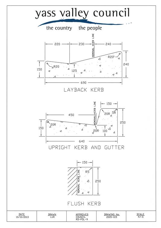
Appendix B
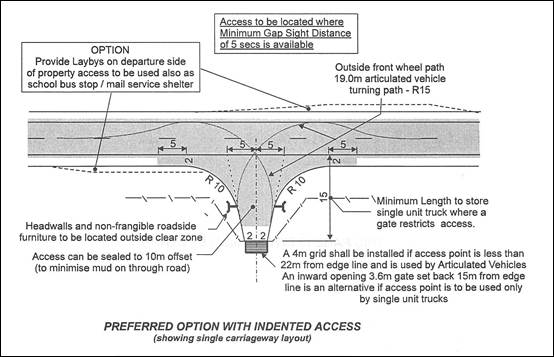
RTA Rural Property Access – Layout 2(SU)
BAR Right Turn Treatment
10. Director of Corporate & Community Reports
|
10.1 Operational Plan Progress Report to 30 September 2014 FILE: M.03.00.00 - SG |
|
SYNOPSIS Advising Council of the status of Key Performance Indicators and Projects identified in the Operational Plan for 2014-2015 for the period ending 30 September 2014.
|
|
RESOLVED that the Operational Plan 2014-2015 Progress Report as at 30 September 2014 be noted. (McManus/Needham) 287 |
|
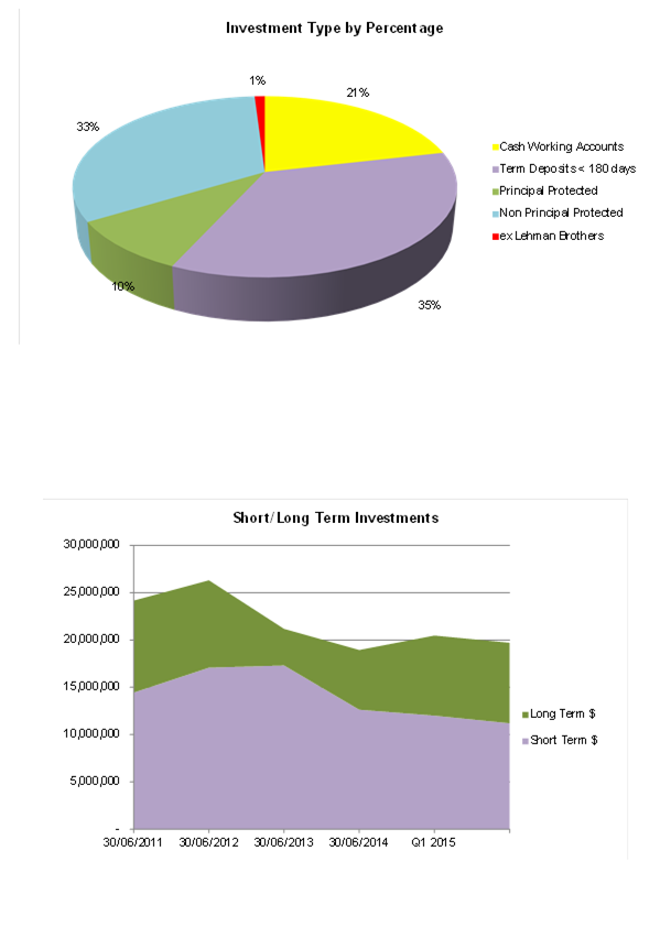
10.2 Investment Report FILE: F.01.04.04 - SD |
|
SYNOPSIS Submitting Investment Report as at 31 October 2014.
|
|
RESOLVED that the Investment Report as at 31 October 2014 be received and it be noted that the summary has been prepared in accordance with the Act, the Regulation and Council’s Investment Policy. (McManus/Needham) 288 |
|
10.3 Legal Services Panel FILE: C.02.06.04 - SG |
|
SYNOPSIS Council take up the option of a further two year appointment of the Legal Services Panel. A Legal Services Panel, as proposed by SEROC, was adopted by Council on 23 May 2012. The term of appointment was for two years commencing 1 June 2012, with an option for a further two year appointment at the discretion of Council. |
|
RESOLVED that Council take up a further two year appointment of the Legal Services Panel as recommended by SEROC: · Marsdens Law Group, Campbelltown · RMB Layers, Nowra · HWL Ebsworth, Sydney/Canberra · Kells The Lawyers, Wollongong · Spark Helmore, Sydney · Williams Love & Nicol, Canberra · Maddocks, Sydney · Elringtons, Canberra/Queanbeyan (McManus/Needham) 289 |
|
10.4 1st Quarterly Financial Budget Review FILE: F.01.00.02 - SD |
|
SYNOPSIS Presentation of the 1st Quarterly Budget Review for the period 1 July 2014 to 30 September 2014 in the financial year ending 30 June 2015. |
|
RESOLVED - 1. That the Quarterly Budget Review Statement for the period ending 30 September 2014 with a deficit of $585,301 be adopted. 2. It is noted that in accordance with the Local Government (General) Regulation (NSW) Section 203 (2)(a), Council’s financial position as at 30 September 2014 is satisfactory, having regard to revised projected estimates of income and expenditure, and the original budgeted income and expenditure. (McManus/Needham) 290 |
11. General Manager Reports
|
11.1 Resolution for 2016 Local Government Elections FILE: E.02.00.01 - JB |
|
SYNOPSIS The NSW Electoral Commission requested Council to amend its resolution in relation to the conduct Council’s 2016 elections. |
|
RESOLVED that - 1. Pursuant to s.296(2) and (3) of the Local Government Act 1993 (NSW)(“the Act”)that an election arrangement be entered into by contract for the Electoral Commissioner to administer all elections of the Council until 2016;
2. Pursuant to s.296(2) and (3) of the Act, as applied and modified by s.18, that a council poll arrangement be entered into by contract for the Electoral Commissioner to administer all council polls of the Council to 2016;
3. Pursuant to s.296(2) and (3) of the Act, as applied and modified by s.18,that a constitutional referendum arrangement be entered into by contract for the Electoral Commissioner to administer all constitutional referenda of the Council to 2016. (Frost/McManus) 291 |
|
11.2 Minutes Statutory, Regional & Council Supported Committees FILE: C.02.03.00 - SG |
|
SYNOPSIS To have Council receive, for information only, the draft minutes of recent meetings of the following Regional and Council supported Committees.
|
|
RESOLVED that the draft minutes of the Yass Valley Rescue Committee Meeting and the Yass Valley Local Emergency Management Committee Meeting held on 29 October 2014 be received for information only. (Butler/Frost) 292 |
|
11.3 High Speed Rail FILE: R01.00.00 - DR |
|
SYNOPSIS The High Speed Rail Forum recently held in Canberra outlined the significance of the project for regional Australia and the need for commitment from all levels of government if the project is to eventuate. The Forum was also seeking confirmation of Council’s position in relation to the project.
|
|
MOVED that Council reaffirms its support in principle for the High Speed Rail project. (Butler/McManus) |
MOTION LOST
|
Motion |
|
RESOLVED That council reaffirms its support in principle for the High Speed Rail project dependent on the routing. (Needham/Butler) 293 |
Councillor Frost requested that his vote be recorded against the motion.
12. Notice of Motion
|
Motion |
|
RESOLVED that a report be brought back to the December meeting in relation to asbestos issues at Allan Park and Hume Park. (Ware/Butler) 294 |
13. Questions with Notice
Nil
14. Confidential Matters
Nil
The
meeting closed at 7.22 pm![]() .
.
Ordinary Council Meeting 17 December 2014
6.1 Draft Minutes of the Murrumbateman Recreation Reserve Grounds Committee Meeting held on 25 November 2014
FILE: C.02.04.02 – TS
To provide Council with the draft minutes of the Murrumbateman Recreation reserve Grounds Committee meeting held on 25 November 2014. The following recommendations are presented for Council’s consideration and adoption.
RecommendationThat Council receive the draft Committee Minutes of the Murrumbateman Recreation Reserve Grounds Committee meeting held on 25 November 2014.
|
Attachments: a. Draft Minutes of the MRRGC Meeting held on 25 November 2014 ⇩
6.1 Draft Minutes of the Murrumbateman Recreation Reserve Grounds Committee Meeting held on 25 November 2014
Attachment a Draft Minutes of the MRRGC Meeting held on 25 November 2014
Clr Greg Butler, Tony Stevens, Libby Turner, Cathy Woodhams, Wayne Miller, Anna Marsden,
Bob Evans, Mike Reid, Terry Hunt, Elizabeth Young.
Guests: Margaret Head, Kim Williams, Robert Wait, Wayne McIllhatton, Lisa Borella.
Clr Butler chaired the meeting
Apologies Clr David Needham , Melanie Singh Leonie Makin.
Declaration of Interest
NIL
.
Confirmation of Minutes
Confirmation of minutes for meeting held 30th September 2014
Woodhams/Reid
Matters Arising from Minutes
Campers:
It was noted that there are a number of campers using the grounds and staying for long periods of time. This needs to be policed.
Mural for Amenities Wall
Committee advised that this was still underway and hopefully would be started early December 2014. The Youth group would be involved in this project. Grant funding was secured for the project.
Post office site:
Committee was advised of arrangements for the room vacated by the Post Office, this area would be used as a shared area between the Field Days office and the Cool Climate Wine Show committee throughout the year leaving the lockable cupboard in the meeting room available for user storage.
Maintenance List
Matters that need urgent attention:
· Spray Blackberry bushes in the creek behind the Men’s Shed and also near the Scout’s shed.
· Noxious week inspectors (Dept of Ag) advised that there was Chilean Needle Grass in the Dundoos paddock that needed spraying. It appears the Chilean needle grass spread from the road verge
· First Aid kit in the hall needs replenishing.
Summary of Finances.
Update not available for meeting
Capital Works Income. $100.000 - Stage Three. New horse arena.
Waiting draft plans for further discussion Site meeting took place on 21 October 2014.
General Business
Stage 3 Planning of the Horse Arena
Interested groups along with committee members & Council staff meet on site to discuss on the 21 October 2014 to discuss suitable options to place the arena.
It was decided the ideal place to locate the new arena would be in the area adjacent the sand arena, would give allow all the horse facilities to be located in the one area.
Draft plans to be circulated to committee when available. Consideration be given to timing of these works as not to interfere with field days and the show jumping weekend.
Mowing Arrangement
Committee advised that the MPA mowing program totalled 250 hours per year, 40 hours to mow the entire site.
As per MPA agreement all groups are to liaise and take joint responsibility for maintaining mowing schedule.
Running costs to be revised with the view of replacing the mower in 2 years’ time at which stage additional funding would be required to purchase a new machine.
Men’s Shed
Advised that building of the free standing veranda attachment to their shed has started.
Shared Storage container:
Mike Reid representing the Murrumbateman Farmers Market thanked the committee for use of the container and expressed their gratitude for the imitative of the committee.
Also asked it there could be more oak trees planted on the south side of the village green to provide add shade.
Solar Avertising Signage on Hall Roof.
The committee agreed that this signage should now be removed as the agreed time for display has expired.
Field Days
Kim Williams spoke about the poor condition of some roads within the site which continually incur repairs costs prior to holding field days.
Mr Williams was advised to formalise his concerns with council.
Next Meeting 27 January 2015
Meeting Closed. 21:10
Ordinary Council Meeting 17 December 2014
FILE: PP-2012-03 & PP-2013-01 – LM
SYNOPSIS
Council has been made aware of potential groundwater contamination risks within the Gundaroo Village. This report considers options for assessing the extent of the problem and ways it could be addressed.
OPERATIONAL PLAN AND BUDGET IMPLICATIONS
Long term Goal 1.1 within the Community Strategic Plan is that ‘Our environment remains clean and healthy’.
Investigations into groundwater contamination issues can be undertaking utilising existing staff resources.
COMMUNICATION PLAN
Letters are proposed to be sent to all owners of ‘RU5 Village’ zoned land within Gundaroo requesting assistance and offering to undertake voluntary water testing of bores free of charge.
SUSTAINABILITY IMPLICATIONS
|
Social |
Groundwater contamination presents possible risks to public health |
|
Economic |
Potential constraint to development of existing village land and efficient use of land |
|
Environment |
Management of on-site sewage management is crucial in preventing the pollution risk to the aquifer. |
|
Governance |
Approval and compliance role under the Local Government Act 1993 for on-site sewage management systems |
|
That: 1. Gundaroo landowners be encouraged to register unlicensed bores within the Gundaroo Village to the NSW Office of Water 2. An offer to undertake voluntary water testing of bores within the Gundaroo Village be extended free of charge to residents |
Attachments: Nil
REPORT
1. Introduction
The recent consultation for the Planning Proposals to rezone land to the north and south of Gundaroo village raised a number of critical issues. One particular issue that was raised by both the community and the NSW Office of Water (NOW) is that of effluent disposal. It appears to be a serious issue for the village regardless of any proposals for growth. The issue also requires consideration in regard to options for the two Planning Proposals.
2. Current situation
Groundwater is a difficult resource to measure, particularly in fractured rock environments such as that of Gundaroo. The groundwater/bore licensing authority is the NSW Office of Water (NOW) not Yass Valley Council. This is one of the inherent problems in managing and protecting groundwater. NOW issue licenses for bores, however there appears to be minimal or no formal monitoring regime in place – which is particularly concerning for domestic bores.
Council receives very limited information from NOW with regard to bores. During consultation with the Gundaroo community, it became apparent that there are unlicensed bores within the village, however Council is not aware of where. This is problematic – particularly when staff may unknowingly approve locations of on-site sewage management facilities (OSMF) within the minimum required 250m buffer to a bore.
Council does issue approvals to operate OSMF under the Local Government Act 1993. It is then the responsibility of the owner/occupier to maintain and operate the facility so that it does not pose a risk to the health of the community or environment. Landowners must ensure all necessary service contracts are in place.
Figure 1 indicates the types of on-site sewage management systems within Gundaroo. A preliminary review of Council’s records indicates there are 100 Aerated Wastewater Treatment Systems (AWTS), 69 Septic Tanks and Absorption Trenches, and a further 9 alternative systems installed (wet composting and dry composting systems).
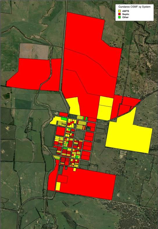
Figure 1: Gundaroo On-Site Sewage Management Facilities
The Gundaroo community has expressed reluctance in the past for reticulated sewerage in the village dating back to the former Gunning Shire Council. Since that time the village has continued to grow through infill development.
Gundaroo has experienced relatively frequent stormwater drainage issues and flooding events. In recognition of this, Council received funding in 2014 under the NSW Government’s Floodplain Management Program to undertake Gundaroo and Sutton Floodplain Risk Management Studies and Plans, and a consultant has been engaged to carry out this work. In addition a village stormwater plan is currently under preparation.
Major rainfall events have the potential to overload absorption areas of traditional systems. Figure 2 details a photo which was taken in the village after the recent early December 2014 rainfall events.
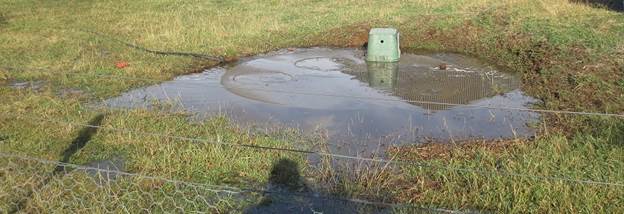
Figure 2: Inundated Septic System
There have been claims that some of the domestic bores within the village may be contaminated, however these claims have not yet been substantiated.
There are a small number of existing lots less than 2,000m2, together with more intensive development such as the recently approved tourist accommodation. These systems are required to be designed to higher specifications and providing they are serviced regularly, they should continue to operate effectively.
A recurring theme in many of the submissions to the Planning Proposals is the existing infill potential within the village. It must be acknowledged that some of the vacant lots are constrained – particularly by drainage issues. Continued reliance on traditional OSMF systems within a village that is prone to flooding and drainage issues is a significant public health risk – particularly given the lack of information on bores, and understanding of the fractured rock aquifer environment.
3. NSW Office of Water
Gundaroo village is identified as being within an area of Groundwater Vulnerability in the LEP (i.e. Groundwater Vulnerability Map). This mapping has been based on data from OEH and NOW (refer Figure 3).
NOW’s response to the Gundaroo Planning Proposals included the following key comments:
· Supportive of reticulated sewer and water to adequately service the proposed lot sizes for the site
· Gundaroo already has a high density of groundwater bores. Planning Proposals may lead to a concentration of basic landholder right bores for domestic and stock purposes
· NOW’s groundwater database shows records of groundwater levels in the local area ranging from 7-20m below ground
· Potential risk for groundwater contamination from irrigated effluent entering the pathways of the fractured rock geology
· Effluent irrigation in areas where groundwater is shallow could pose a potential risk for contamination from direct infiltration of effluent into groundwater
· NOW is supplied with limited data of groundwater quantity and quality upon drilling of each bore
· Concern with AWTS is that their use in concentrated areas may cause potential impacts on groundwater
· Supports Council investigating decentralised wastewater treatment options for higher density housing such as that proposed at “Kyeema”
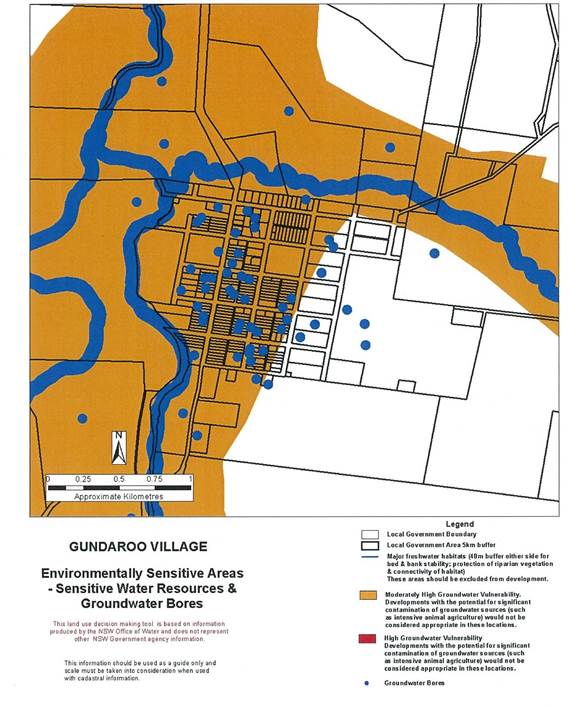
Figure 3: Groundwater Vulnerability and Licensed Bore locations
4. Possible Solutions
As Council has been made aware of the possible contamination of bores/groundwater within the village, there is a duty of care to investigate and take action where necessary.
Bore Testing
One of the first steps in resolving this issue is to determine the extent of the problem. As Council is not the licensing authority for groundwater, and NOW appears reluctant to take on any regulatory role, there will need to be willingness and cooperation within the community in order to resolve the problem.
Council staff recently met with members of the Gundaroo Community Association Executive, and have requested assistance in sourcing residents who would be willing to share bore monitoring results or access to bores for water testing.
As Council does not have access to data on bore water quality within the community, it is considered reasonable that Council undertake water testing for any concerned residents free of charge. There will not be any mandatory water testing undertaken by Council, however this may be required by NSW Health or NOW in the future if a significant contamination problem is detected.
There have been misleading references within the community to the testing results within the monitoring bore on the southern Planning Proposal site. It is noted that the initial May 2014 sampling from the monitoring bore recorded a confirmed EColi reading of 24 CFU/100ml This reduced to a reading of 6 CFU/100ml. in the June 2014 reading (similar to that of the nearby dam). The report by Barker Harle (July 2014) postulates that the Ecoli/ faecal coliform reading is likely to have been caused by the use of the farm dam water during the drilling of the borehole, thus cross contaminating the sample. The borehole was disinfected and tested again in November 2014 with a normal reading of <2 CFU/100ml.
OSSMF Inspections
Council’s records indicate that a high number of AWTS systems do not appear to be serviced regularly. Likewise, there is anecdotal evidence of issues with the operation of septic tanks and absorption trenches. One of the solutions could be an audit to identify systems which are at risk of failure. Systems can fail due to inadequate maintenance, age of the system or overloading. These systems would then be required to be upgraded or replaced. Individual owner would then need to demonstrate that servicing and maintenance regimes had been adhered to.
Any audit and inspection regime would need to be appropriately scoped and resourced by Council as well as an appropriate inspection fee.
Identification of Bores
Council is aware of the existence of a number of bores which are not registered and mapped by NOW as shown in Figure 3. It is in the public health interests of the owners and the wider community to ensure their location is known, to avoid the location of OSMF within the 250m buffer and risking contamination.
Again, as Council is not the licensing authority, this again relies on the willingness and cooperation of the community.
Treatment Plant
Some of the submissions received from the community in relation to the Planning Proposals raised the issue of reticulated sewerage within the village. Some of the questions raised were:
· Has an STP had been budgeted for?
· Should pipe routes/easements be planned for now?
· Has a site for the STP been determined?
· Impact of STP costs on existing residents?
Whilst it is acknowledges that there has been community opposition in the past, in the event that a significant contamination problem is detected, consideration may need to be given to a reticulated sewerage system for the village. In addition, the changing pattern of storm and flood events may increase the risk of OSMF failing due to inundation. An indicative costings and feasibility report is currently underway for reticulation of Gundaroo Village.
Planning Proposals
The assessments of the Planning Proposals are being finalised including consideration of significant issues such as servicing. The risks to groundwater within the existing village appear to be present regardless of whether any village expansion occurs or not, and affects further infill of the village – particularly those subject to drainage issues.
Any decision on the Planning Proposal sites will require the same considerations and approach to effluent disposal consistent with the village, including possible flood mitigation works, buffer distances, moratorium on new bores or connection to a village reticulated sewerage system.
Ordinary Council Meeting 17 December 2014
8.2 Parkwood Planning Proposal - Gateway
FILE: PP-2014-01 – LM
SYNOPSIS
For Council to consider progression of the Parkwood Planning Proposal and seek a Gateway Determination for public consultation.
OPERATIONAL PLAN AND BUDGET IMPLICATIONS
3.2.3.3 - Actively engage with the community and encourage participation on short, medium and long term land use planning and environmental matters of importance to the Yass Valley.
COMMUNICATION PLAN
Given the Planning Proposal is for a large, complex, long term development, it is recommended that public exhibition should be undertaken for a minimum of 40 days to provide the opportunity for interested and affected residents to comment on the proposal.
Public Exhibition would be undertaken in accordance with Council Procedure SP-OP-1 Public Exhibition – Strategic Land Use Planning. Given the remote accessibility of the site to the rest of the LGA, it is considered appropriate to direct interested residents at the existing shopfront at Kippax, and to have an information display at Yass.
Although the site has abuttal to the ACT, the adjoining land is under 99 year leasehold by the Corkhill Brothers (parent company of Reid and Stevens Pty Ltd) and that land is the subject of the amendment to the ACT Territory Plan for West Belconnen. It is therefore unnecessary to notify the current leaseholder.
A significant amount of pre-lodgement consultation has occurred for this Planning Proposal over the past few years. This has included:
· 3 day Planning Design Forum/Workshop – November 2013
· ‘Talk West Belconnen’ Website
· West Belconnen Facebook Page & Twitter
· Project Shop front – Kippax Centre, ACT
· Community and Stakeholder Vision Workshop
· Electronic Newsletters
· Numerous meetings/presentations with Yass Valley Council Staff and Councillors
· Site visits/discussions with agency representative (e.g. OEH)
Council has had numerous representations over recent years from the Ginninderra Falls Association, with regard to a proposal for the establishment of a National Park. Council also has a relationship with the Ginninderra Catchment Group whose primary focus is advancing the health of the Catchment. Both these groups will be notified directly during the exhibition period.
SUSTAINABILITY IMPLICATIONS
|
Social |
The design of residential neighbourhoods will need to provide for social interaction and community facilities. |
|
Economic |
The proposal would generate additional construction activity within the regional economy. |
|
Environment |
The proposal includes refinement of the E3 Environmental zone boundary and concept of Trust to manage the Conservation Corridor. |
|
Governance |
Council has a role to consider Planning Proposals as the relevant planning authority in accordance with s54 Environmental Planning & Assessment Act 1979. |
|
That: 1. Planning Proposal PP-2014-01 for ‘Parkwood’ be endorsed and forwarded to the Minister for Planning to request a Gateway Determination pursuant to s56 Environmental Planning & Assessment Act 1979 2. The the Department of Planning & Environment be requested to assist in undertaking Community Consultation and any Public Hearing for the Planning Proposal.
|
Attachments: a. Department of Planning & Environment Response ⇩
REPORT
1. Introduction
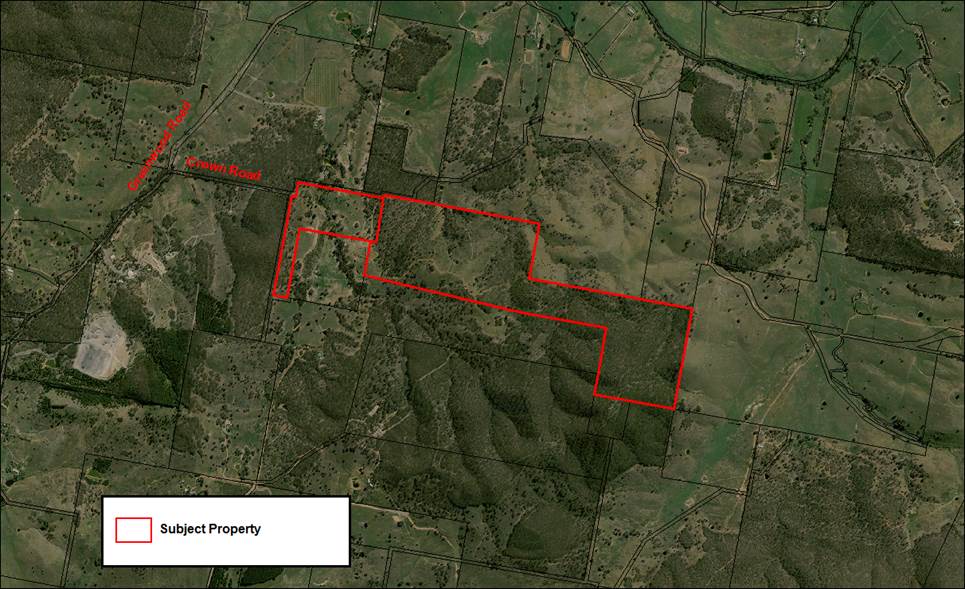
Council was advised at its meeting of 23 July 2014 of the receipt of a Planning Proposal for the NSW component of the West Belconnen development known as ‘Parkwood’. A location plan of the subject land is shown in Figure 1.
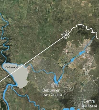
Figure 1: Parkwood Location Map – Subject Site
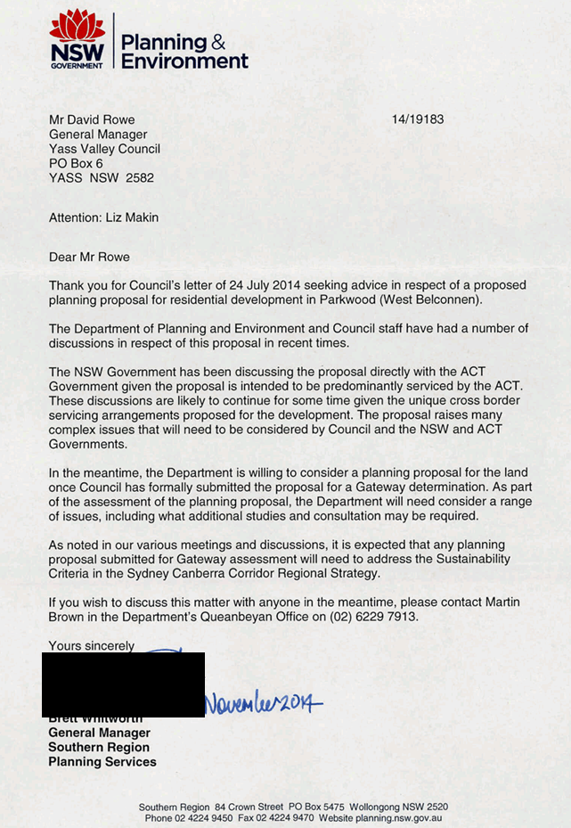
The Planning Proposal currently sits outside Council’s Strategic Land Use Planning carried out to date. The current Sydney Canberra Corridor Regional Strategy also makes no reference to cross border development of this kind. Council determined that the Department of Planning & Environment be advised of the lodgement of the Planning Proposal and be requested to indicate their formal strategic position on Parkwood.
A response has been received (refer Attachment A) and although it does not provide a formal strategic position, it does state that:
· There have been discussions with the ACT
· The proposal raises many complex issues that will need to be considered by Council and the NSW and ACT Governments
· DP&E is willing to consider the Planning Proposal once Council formally submits it for a Gateway Determination
Given the above, Council is now required to consider whether to progress the proposal to Gateway.
2. Planning Proposal
The Planning Proposal has been submitted by Riverview Projects and involves the following key elements:
· Area of approximately 600 ha
· Approximately 394 ha for urban purposes
· Approximately 206 ha for conservation/riparian uses
· Total number of dwellings is approximately 5,000 with an estimated population of 13,000
· Overall release of West Belconnen/Parkwood estimated to be 11,500 dwellings
· Creating a new principal LEP for the land
The Planning Proposal seeks:
· To amend the Yass Valley LEP 2013 by amending the ‘Land Application Map’. This would have the effect of removing the application of the current Yass Valley LEP 2013 to the subject land
· To prepare a new LEP which would apply only to the subject land which would be known as Yass Valley (Parkwood) LEP
· To include an ‘Urban Release Area Map’ within the Yass Valley (Parkwood) LEP
· To include a provision in the Yass Valley (Parkwood) LEP which requires that satisfactory arrangements be made for the provision of designated State and Territory public infrastructure before the subdivision of land in a designated urban release area.
In terms of proposed Land Use Zoning:
· The proposed zone boundaries are proposed to be consistent with the master plan prepared by Roberts Day shown in Figure 2
· The rezoning of the land from ‘RU1 Primary Production’ to ‘R1 General Residential’
· The rezoning of the land from ‘RU1 Primary Production’ to ‘E3 Environmental Management’ where it aligns with the confirmed riparian and conservation values of areas adjacent to Ginninderra Creek. The zone boundary is to reflect the findings of the environmental and ecological surveys undertaken on behalf of the proponent
· Amending by zoning of part of the land currently zoned ‘E3 Environmental Management’ to ‘R1 General Residential’
· Amending the land use tables for the ‘R1 General Residential’ zone and ‘E3 Environmental Management’ zones as they will apply to the proposed Yass Valley (Parkwood) LEP - i.e. the permitted land uses within the Yass Valley (Parkwood) LEP are proposed to be different to those within the current Yass Valley LEP 2013
Two options are to be considered for Minimum Lot Sizes within the Planning Proposal:
· The adoption of a minimum lot size (proposed to be 250m2) over the land proposed to be zoned R1 General Residential together with the inclusion of a provision providing for an exception to the minimum lot size subject to the preparation of a local neighbourhood plan incorporated into a Development Control Plan (DCP)
or
· To not include a minimum lot size in the LEP. The LEP would specify that urban development could not be undertaken until such time as a minimum lot size is specified in a neighbourhood plan or similar (that is a DCP)
The proponent hopes that the Planning Proposal for ‘Parkwood’ will be considered concurrently with its parallel rezoning submission, Draft Amendment to the Territory Plan #351 for the adjacent ‘West Belconnen’ land. The Amendment has been formally lodged with the ACT Government. It should be noted however that due to the proposed staging, the applicant has provided an estimated timing of 2024 before land would be released in NSW.
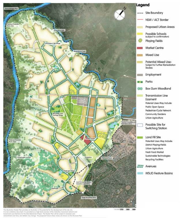
Figure 2: West Belconnen - Parkwood Master Plan – Roberts Day
The Planning Proposal for Parkwood and the amendment to the Territory Plan for West Belconnen are the result of a large number of studies, reports and an intensive design forum in November 2013. These reports are included as appendices to the Planning Proposal and are listed below:
|
Study/Report |
Consultancy |
|
Urban release NSW Position Paper |
Knight Frank |
|
Agricultural Lands Review |
Edge Land Planning |
|
Visual Impact Assessment |
Roberts Day |
|
Landscape and Open Space Strategy |
McGregor Coxall |
|
Proposed West Belconnen Conservation Area |
TRC Tourism Pty Ltd |
|
Urban Capability |
Douglas Partners |
|
Flora and Fauna and Targeted Bird Survey |
Kevin Mills and Associates |
|
Archaeological Report |
Biosis |
|
Phase 1 Environmental Assessment (Contamination) |
AECOM |
|
Masterplan |
Roberts Day |
|
Integrated Sustainable Transport Plan |
MR Cagney |
|
Community Plan |
Elton Consulting |
|
ACTEW Water Letters of Support |
ACTEW Water |
|
Environmental Trust for West Belconnen |
Elton Consulting |
|
Bushfire Management Strategy |
Ecological Australia |
|
Geotech Report – Urban Capabilities |
Douglas Partners |
|
Water Summary |
AECOM |
|
Buffer zone for Parkwood Egg Farm |
CEE Consulting Environmental Engineers |
|
West Molonglo Urban Development Project |
Lindsay Taylor |
|
Sewer and Water Concept Plan |
Browns |
|
Extent of Habitat for Pink Tailed Worm Lizard |
Will Osborne and David Wong (UC) |
|
European Cultural Heritage Reports |
Eric Martin & Assoc |
|
Traffic Report |
AECOM |
The following points are key notable features of the site:
· Site is primarily exotic grassland and largely cleared of woodland above the river and creek gorges
· Scattered areas of Box Gum Woodland regrowth occur on edge of the gorge
· Transgrid High voltage transmission lines extend north west to south east over the site
· Murrumbidgee flooding confined within the steep riparian areas
· An indicative 1 in 100 year flood line has been provided along Ginninderra Creek, however a broader study incorporating the larger catchment is being prepared
· Habitat for the Pink Tailed Worm Lizard in the rocky area above the river. This may trigger the TSC and/or EPBC Act, and the significance of the impact will need to be specifically assessed
· Three threatened bird species were recorded in the open farmland i.e. Flame Robin, Scarlet Robin and Spotted Harrier
· Field Survey identified sixteen Aboriginal Cultural Heritage Sites mainly comprising small artefact scatters or isolated finds. Many of these would be due to the presence of the waterways and pathways of the Murrumbidgee River and Ginninderra Creek
· Part of the land within NSW is within a 500m Parkwood Egg Farm Buffer. It is intended to restrict development within the buffer area until operations cease. The egg farm has a limited land lease from the ACT until 2033
· The applicants contend that the grazing potential of the site is limited due to the location of the land- having to move stock through urban parts of Canberra, and domestic dog attacks upon sheep
· Landscape features and topography of the site are shown in Figure 3 below. The eastern portion of the site is gently undulating while the land slopes down (steeply in sections) toward the Murrumbidgee River;
· The major landscape feature of the entire site is the Ginninderra Falls, situated just upstream of the confluence of Ginninderra Creek with the Murrumbidgee River shown in Figure 4.
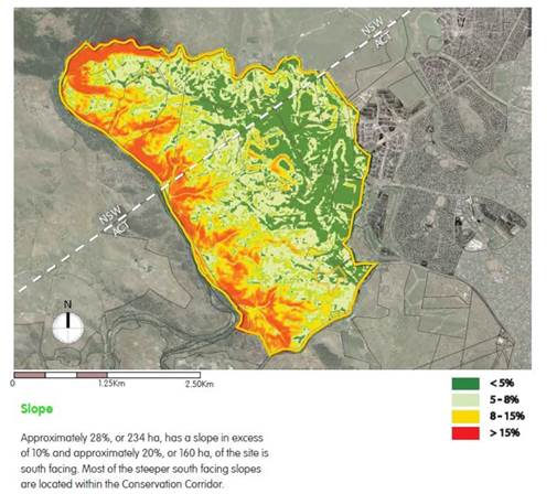
Figure 3: Topography Map (Roberts Day)

Figure 4: Ginninderra Falls
In relation to The Murrumbidgee River and Ginninderra Creek conservation corridor, this land is proposed to be privately managed through a Trust. It is intended to do this through a Conservation Agreement under the National Parks & Wildlife Act 1974, which would set out a strategic framework and a plan of management including responsibilities.
Main objectives of the Trust are proposed to be conservation of natural values and bushfire fuel management. It is intended that it be administered by a company with a board comprising government and community representatives and other stakeholders. Committees encompassing Land Management, Social Sustainability and Public Funds are proposed to be established. The Planning Proposal states that the Trust would earn annual income through a percentage of sale proceeds (NSW land only) and an annual contribution from the ACT equal to those costs of managing the ACT portion of the corridor.
Ginninderra Falls are proposed to be reopened for recreation/tourism purposes with educational facilities.
3. Land Use & Tenure
The Parkwood Site has abuttal along its south eastern boundary to the ACT. Although within NSW, the site can only be accessed through the ACT via the Barton Hwy – Kingsford Smith Drive – Southern Cross Drive/Parkwood Road route.
The Parkwood Planning Proposal extends over all land within the Parkwood peninsula as shown in Figure 1, comprising the following land under the respective ownerships:
|
Land |
Owner |
Existing Use |
|
Lots 1,2,3 & 7 DP 771051 |
Reid and Stevens Pty Ltd |
Agriculture & Grazing |
|
Lot 61 DP 801234 |
A & J Hyles |
Red Granite Quarry & Former Ginninderra Falls Recreation Area |
|
Lot 4 DP 771051 |
E Shaw and G Armitage |
Agriculture & Grazing |
|
Lot 5 DP 771051 |
P Fleming and G Moore |
Dwelling/Agriculture & Grazing |
|
Lot 62 DP 801234 |
S Scibberas |
Ginninderry Homestead – Accommodation /Day Spa /Function Centre |
The ACT portion of the proposal is known as ‘West Belconnen’. It is held under a 99 year rural lease by the Corkhill Brothers, (whereas in NSW it is freehold). It is currently characterised by urban related infrastructure such as the electricity substation, transmission lines and landfill, together with the Parkwood Egg Farm.
4. Council Planning Proposals Policy
Council’s Planning Proposals Policy (SEP-POL-1) outlines the requirements for the submission of Planning Proposals to Council.
The policy states that a Planning Proposal will only be considered by Council if the land has been identified as a ‘Future Investigation Area’ in the Yass Valley Town and Villages Study. It does however state that if an exceptional, innovative Planning Proposal is forwarded to Council, which falls outside those areas, it will be considered if it satisfies:
· The ‘Threshold Sustainability Criteria’ outlined in Appendix 1 in the Sydney Canberra Corridor Regional Strategy, or
· NSW and ACT regional strategies for development adjacent to or across the ACT border.
To enable Council to ascertain whether a Planning Proposal should be supported, it needs to be accompanied by supporting information which demonstrates that the above, together with all other constraints have been considered.
5. Yass Valley LEP
The subject land is currently zoned part ‘RU1 Primary Production’, and part ‘E3 Environmental Management’ under the Yass Valley Local Environmental Plan 2013 (YVLEP 2013) shown in Figure 5 below.
The RU1 zoning extends over the majority of the rural–non urban lands within the Yass Valley LGA. One of the objectives of the RU1 zone is:
· To prevent the subdivision of land on the fringe of urban areas into small lots that may prejudice the proper layout of future urban areas
The Parkwood peninsula is held in the ownership of five parties, and thus the RU1 zone has been effective in preventing excess subdivision and fragmentation of this land on the fringe of ACT urban lands.
The objectives of the E3 zone are:
· To protect, manage and restore areas with special ecological, scientific, cultural or aesthetic values
· To provide for a limited range of development that does not have an adverse effect on those values
The extent of the E3 zone was transferred from the provisions of the ‘7(e) Environmental Protection’ Zone under the Yarrowlumla LEP 2002 and it is unknown how the boundaries of this zone were established.
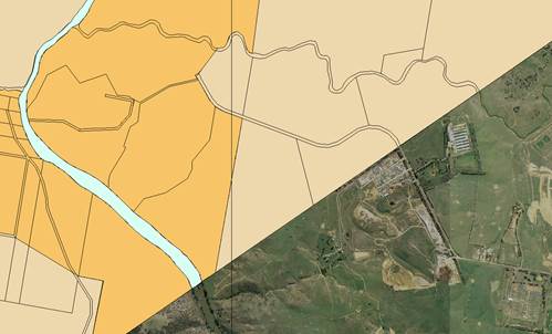
Figure 5: Zoning of the subject site
![]() RU1
RU1
![]() E3
E3
Parts of this site have been identified as subject to ‘High Soil Erodibility’ as detailed on the Natural Resources Maps within the YVLEP 2013 (refer Figure 6). Development on this land must be designed so as to avoid, minimise or mitigate adverse environmental impact. Proposals must consider whether they are likely to have any adverse impact on soil erosion processes on the land or whether soil erosion is likely to have an impact on the development.
It is noted that the areas subject to high soil erodibility are generally restricted to the steeper areas of the site, including those associated with the riparian/gorge areas of the Murrumbidgee River and Ginninderra Creek. It is noted that these areas are proposed to be retained within the proposed E3 zoning.
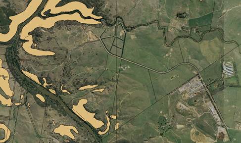
Figure 6: High Soil Erodibility
The Murrumbidgee River and Ginninderra Creek are shown as ‘Riparian Lands and Watercourses’, and a large portion of the subject site is subject to ‘Groundwater Vulnerability’ as detailed on the Natural Resources Maps within the YVLEP 2013 (refer Figure 7). The area of the site identified as having Groundwater Vulnerability can be attributed to the adjacent Murrumbidgee River and Ginninderra Creek.
The YVLEP 2013 requires that consideration is given to:
(a) the likelihood of groundwater contamination from the development (including from any on-site storage or disposal of solid or liquid waste and chemicals),
(b) any adverse impacts the development may have on groundwater dependent ecosystems,
(c) the cumulative impact the development may have on groundwater (including impacts on nearby groundwater extraction for a potable water supply or stock water supply),
The proposed urban areas will require connection to urban utility services (e.g. water, sewer and stormwater) to minimise impacts on groundwater.
For riparian land and watercourses the YVLEP 2013 requires consideration to be given to whether a development will have an adverse impact upon:
(i) the water quality and flows within the watercourse,
(ii) aquatic and riparian species, habitats and ecosystems of the watercourse,
(iii) the stability of the bed and banks of the watercourse,
(iv) the free passage of fish and other aquatic organisms within or along the watercourse,
(v) any future rehabilitation of the watercourse and riparian areas, or
(vi) whether or not the development is likely to increase water extraction from the watercourse,
The riparian areas are proposed to be included within the E3 zone and the corresponding conservation corridor.
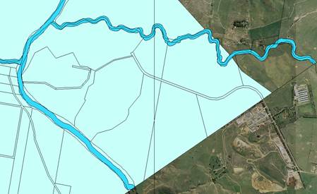
Figure 7: Riparian land and watercourses & Groundwater Vulnerability
The areas of the site identified as having ‘Biodiversity’ values are detailed on the Natural Resources Maps within the YVLEP 2013 (refer Figure 8). This area is identified as having values associated with ‘Tablelands Box Gum Woodland’. The YVLEP 2013 requires consideration whether the development will have:
(i) any adverse impact on the condition, ecological value and significance of the fauna and flora on the land, and
(ii) any adverse impact on the importance of the vegetation on the land to the habitat and survival of native fauna, and
(iii) any potential to fragment, disturb or diminish the biodiversity structure, function and composition of the land, or
(iv) any adverse impact on the habitat elements providing connectivity on the land;
The biodiversity areas are largely to be retained within the E3 zone and the conservation corridor.
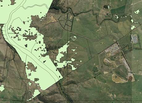
Figure 8: Biodiversity
6. Sydney-Canberra Corridor Regional Strategy
Despite the presence of the border, the physical constraints which define the boundary of this site – the Murrumbidgee River and Ginninderra Creek - mean that it has it’s nexus with existing development within the ACT rather than NSW. For this reason, the site is extremely unique within the Yass Valley and for development surrounding the ACT.
This proposal has a discrete area which would not have the effect of eroding the ACT border and settlement boundary. The biggest development pressure for YVC is development spill over into NSW and beginning a slow creep towards existing settlements within the Yass Valley. The Yass Valley - ACT border is otherwise intact and characterised by the visual buffer of the rural landscape, however in this instance the Murrumbidgee and Ginninderra waterways would present as a defined urban edge.
The Sydney Canberra Corridor Regional Strategy (2008) does not specifically discuss or anticipate cross border development between the ACT and the Yass Valley. Its overarching principles of directing future residential growth to, or to be contiguous with existing centres is very relevant, as is building upon existing infrastructure and regional services. In this instance however, Canberra is the major centre rather than a local NSW regional centre.
The Sydney Canberra Corridor Regional Strategy anticipated that the joint ACT-NSW Settlement Strategy would be undertaken, and this did commence in the form of C+1, however has not progressed. This strategy was to identify cross-border infrastructure implications of development and appropriate funding mechanisms, including developer contributions. In the absence of this strategy and these mechanisms, these issues need to be dealt with on a site specific basis.
The Sydney Canberra Corridor Strategy states that additional development sites outside the settlement framework should only be considered if it can be demonstrated that the Sustainability Criteria can be satisfied. The criteria have been considered as follows:
|
Threshold Sustainability Criteria |
Response |
|
1. Infrastructure Provision Mechanisms in place to ensure utilities, transport, open space and communication are provided in a timely and efficient way |
Infrastructure would be extended and provided from within the ACT. A report on options for service delivery arrangements has been prepared by Elton consulting (see section on YVC implications for further detail). A ‘Heads of Agreement’ has been entered into between Riverview and the ACT Government, confirming that the ACT will provide the provision of water and sewer infrastructure and services to permit the development of the NSW land. Planning for Transport, Open Space and Community facilities will be required to be carried out in an integrated way with ‘West Belconnen’. The ‘Urban Release Area’ provisions in a future LEP would require ‘satisfactory arrangements be made for the provision of designated State and Territory public infrastructure before the subdivision of land in a designated urban release area.’ The levying of section 64 and 94 contributions, or entering into Voluntary Planning Agreements will be the subject of further discussion and negotiations. |
|
2. Access Accessible transport options for efficient and sustainable travel between homes, jobs, services and recreation to be existing or provided |
An ‘Integrated Transport Plan’ has been prepared by MR Cagney, and a Technical Traffic Report by AECOM. In comparison to the rest of the Yass Valley LGA, ‘Parkwood’ has the potential for integrated public transport and linkages with the ACT. Parkwood is a highly accessible site, with vehicle trips/movements are likely to be significantly lower- especially for employment and retail purposes. |
|
3. Housing Diversity Provide a range of housing choices to ensure a broad population can be housed |
The Masterplan and intended minimum lot size indicates greater density and diversity than elsewhere in the Yass Valley. While it would contribute to geographic spread of supply, it would primarily be meeting the needs of the ACT including affordable and adaptable housing. The NSW government will need to determine whether meeting these regional diversity and choice targets is acceptable where the main benefits will be realised for the ACT. |
|
4. Employment Lands Provide regional/local employment opportunities to support the Sydney-Canberra Corridor’s expanding role in the wider regional and NSW economies |
The site is likely to provide employment lands, although again the ACT market will be the main beneficiary. In the medium to longer term, development of this land will create a number of jobs in the construction industry – some of which are likely to draw employees from the Yass Valley. There is a risk that Parkwood-West Belconnen may compete with Yass and the villages. It is therefore important that YVC continues to build upon its identity and differentiate itself from the ACT. |
|
5. Avoidance of Risk Land use conflicts, and risk to human health and life, avoided |
Reports have been provided to address the following risks: · Urban Capability · Phase 1 Environmental Assessment (Contamination) · Bushfire Management Strategy · Geotech Report – Urban Capabilities · Buffer zone for Parkwood Egg Farm It is considered that satisfactory preliminary consideration has been given to risk across the site. These risks will be reviewed by the various stakeholders and public agencies during the consultation period. |
|
6. Natural Resources Natural resource limits not exceeded/ environmental footprint minimised |
The proposal has given due consideration to minimising the environmental footprint of the development, in proposing Water Sensitive Urban Design, Community Gardens/Urban Agriculture and a Green Building Council 6 star community. There would also be increased access to Public transport, and fewer vehicle trips. |
|
7. Environmental Protection Protect and enhance biodiversity, air quality, heritage and waterway health |
Assessments have been undertaken on the biodiversity and Aboriginal Cultural heritage of the site. The recommendations will largely be given effect by a refined E3 boundary and the establishment of a Trust to manage the conservation corridor. |
|
8. Quality and Equity in Services Quality health, education, legal, recreational, cultural and community development and other government services are accessible |
The unique location of Parkwood means that services would be available and accessible within the ACT. The extent of NSW/YVC cost sharing or servicing agreements will be the subject of further discussion. It is acknowledged that a major issue with the NSW Service provision will be that of government schools given the difficulties currently being experienced by Murrumbateman and within other LGA growth areas. This issue has already been raised as a priority cross border issue that requires significant negotiation with the Department of Education & Communities. |
It should be noted that work on the South East and Tablelands Regional Growth and Infrastructure Plan has commenced, and the plan will supersede the Sydney Canberra Corridor Regional Strategy. The DP&E are liaising with YVC on cross-border development- specifically this site, and it is expected that the preparation of the plan will take these cross-border growth and serving issues into account.
7. ACT/NSW Settlement Agreement
The ACT–NSW Cross Border Region Settlement Memorandum of Understanding (MOU) was entered into in 2006, and contained a number of settlement principles for the region.
The Parkwood Planning Proposal is considered to satisfy the principles within the MOU, namely that settlement of this area would maximise the efficient use of infrastructure and services from within the ACT, and minimise the need for additional infrastructure, thereby minimising the economic and community costs of provision and maintenance.
The areas identified for settlement propose to protect areas of high conservation and landscapes through setting aside a Conservation Corridor proposed to be managed through a Trust. The ‘E3 Environmental Management’ zoning applying to that land would limit uses and development which might compromise the unique values of the land.
The Planning Proposal is also consistent with the principle that development be complementary and integrated into land uses on the other side of the ACT border. It is proposed that Parkwood and West Belconnen be considered concurrently to allow for integrated planning of the land across the border. It is also noted that West Belconnen is mentioned strategically within the ACT Planning Strategy (2012) which states areas for future possible settlement within the ACT, including Kowen Plateau in the east and west Belconnen, will be considered in a regional context and in terms of their interrelationships with immediately adjoining areas of NSW.
The concept for development of Parkwood demonstrates a high level of urban containment which would enhance access to and efficiency of services and transport. The Masterplan for the site demonstrates the intention to release the land in a staged manner radiating out from the ACT – consistent with the demand from Canberra.
It is acknowledged that the ACT portion of the development is intended to progress ahead of NSW. The NSW land will be safeguarded in the medium to long term through the ‘Urban Release Area Map’ within the Yass Valley (Parkwood) LEP, which will require satisfactory arrangements be made for the provision of designated State and Territory public infrastructure before the subdivision of land in a designated urban release area. It should be noted that in the event that approval is not granted for the ACT component, development of Parkwood may become untenable. YVC’s position may need to be reviewed if this occurs.
The MOU states that water may be supplied to any proposed settlement where both ACT and NSW agree. ACT have recently entered into a Heads of Agreement with Riverview in relation to the provision of water and sewer to Parkwood. The Heads of Agreement contains details which are commercial in confidence and is unable to be made publicly available. The terms of this agreement will be considered as part of the more detailed Infrastructure Delivery Plan.
8. Yass Valley Implications
The implications for YVC are wide ranging, however much of the detail regarding cross border infrastructure and service delivery has not yet been determined. The proposed scale and lead time for this project requires mechanisms and safeguards to be in place to ensure that the detail is resolved prior to development. As such, Parkwood is proposed to be designated as an urban release area within the proposed Yass Valley (Parkwood) LEP.
It is proposed to include provisions that:
a. Address arrangements for designated State and Territory public infrastructure. The objective of this provision is to require that satisfactory arrangements be made for the provision of designated State and Territory public infrastructure before the subdivision of land in a designated urban release area.
b. Provision of public utility infrastructure. This provision will require that development consent is not to be granted unless Yass Valley Council is satisfied that any public utility infrastructure that is essential for the proposed development is available or that adequate arrangements have been made to make that infrastructure available when it is required
c. Require the preparing and adopting of a Development Control Plan. The objective of this provision will be to ensure that development in Parkwood occurs in a logical and cost effective manner, in accordance with a staging plan and only after a development control plan that includes specific controls has been prepared. The applicant has indicated that those controls are expected to be:
· A staging plan for the timely and efficient release of urban land, making provision for necessary infrastructure and sequencing
· An overall transport movement hierarchy showing the major circulation routes and connections to achieve a simple and safe movement system for private vehicles, public transport, pedestrians and cyclists
· An overall landscaping strategy for the protection and enhancement of riparian areas and remnant vegetation, including visually prominent locations and detailed landscaping requirements for both the public and private domain
· A network of active and passive recreation areas
· Stormwater and water quality management controls
· Amelioration of natural and environmental hazards including bush fire, flooding and contamination
· Detailed urban design controls for significant sites
· Measures to encourage higher density living around transport, open space and service nodes
· Measures to accommodate and control appropriate neighbourhood commercial and retail uses
· Suitably located public facilities and services including provision for appropriate traffic management facilities and parking
The Planning Proposal also includes a report on NSW service delivery arrangements i.e.
|
Function |
Potential Options |
|
Rates and Charges |
- YVC undertakes collection functions. Income obtained from YVC could be used to fund contractual arrangements with ACT. - Servicing agreement required between YVC and ACT Government. - Negotiation of Section 94, Voluntary Planning Agreements and/or other funding mechanism. |
|
Residential Waste and Recycling |
- YVC undertakes functions directly or - YVC undertakes functions via a contractor or - ACT NOWaste undertakes functions via a contractor. - Income obtained by YVC from waste management charges could be made available to ACT. - Potential requirement for servicing agreement between YVC and ACT Government |
|
Residential water and sewer |
- ACTEW owns the infrastructure, ACTEW Water supplies the water and receives and treats the effluent or - YVC owns the infrastructure, ACTEW Water supplies the water and receives and treats the effluent. - YVC Sewer charge could be redistributed to ACT? - Detail of specific infrastructure required to be provided within the Infrastructure Delivery Plan. *Heads of Agreement confirms that the ACT will provide as part of the development of the land (within the ACT), infrastructure and services to permit the development of the NSW Land. |
|
Electricity and gas |
- ACTEWAGL owns electricity infrastructure in ACT, Essential Energy owns electricity infrastructure in NSW. - ACTEWAGL and Essential Energy provide electricity services on both sides of the border. - ACTEWAGL owns gas infrastructure and provides gas services on both sides of the border. |
|
Roads and Street Lighting |
- Vested in YVC with YVC undertaking maintenance and renewal functions or - Vested in YVC with ACT undertaking maintenance and renewal functions under a servicing agreement with YVC or - Held in Community Title |
|
Parks and Open Space |
- YVC undertake functions in NSW or - ACT undertake functions in NSW under servicing agreement with YVC. |
|
Fire, rescue and ambulance services |
- Functions provided on both sides of the border as per existing MOU between the ACT and NSW Governments. *changes may occur in funding arrangements – with regard to the way in which contributions are calculated in NSW (i.e currently based on Council population – may move to a property based levy) |
|
Policing |
- Function undertaken in NSW by NSW Police, with inter-jurisdictional cooperation. Discussions are ongoing. |
|
Development Assessment |
- YVC undertakes functions – possible assistance from consultant or - YVC delegates some functions to ACT or - ACT undertakes all functions legally permissible. It is intended that the LEP/supporting DCP will be designed so that the majority of residential development can be complying. Potential for a service agreement between YVC and ACT to undertake functions. |
|
Schools |
- Public primary schools provided in NSW by NSW Education and Communities. - Public High School provided in ACT with NSW students able to access school under Priority Placement Policy. |
|
Library |
- Library functions provided in ACT by ACT Government and able to be accessed under servicing agreement. - Library could be in form of expansion of existing Kippax library or a local outlet be co-located with a community centre. Masterplan currently locates the ‘local centre’ in the ACT. |
|
Child and family care |
- Private sector undertakes functions. |
|
Health services |
- Function undertaken in NSW by NSW Government. Residents of NSW able to access services in the ACT. - Currently no formal agreement between ACT and NSW Governments regarding cost allocation. - Current MOU for ACT-NSW Regional Collaboration contains a priority action relating to integrated service provisions (location, sequencing, cost sharing). |
|
Integrated Planning and Reporting |
- YVC undertakes functions with assistance from ACT Government. |
|
Ranger services |
- Functions in NSW undertaken by YVC or - Functions in NSW delegated to ACT. - ACT could undertake functions in NSW under servicing agreement with YVC. *Compliance – abandoned vehicles and illegal dumping |
|
Companion animals |
- Functions in NSW undertaken by YVC or - Functions in NSW delegated to ACT. - ACT could undertake functions in NSW under servicing agreement with YVC. |
Whilst there is likely to be a split in functions between YVC/NSW and the ACT, it is likely that there will be a need for provision or access to YVC/NSW administrative functions locally within the Parkwood Peninsula (e.g. RMS Registry, YVC Kiosk for rates enquiries etc) The extent of the functions required is impossible to determine at this stage, however by way of comparison, the population of the Yass Valley in 2013 was 16,270 and Yass Town’s population was 5,591. The Parkwood Planning Proposal incorporates a concept for 5,000 dwellings with an estimated population of 13,000.
This is the first consideration of Cross Border Development for the Yass Valley LGA, and its potential for precedent must be carefully considered given the number of speculative development enquires along the ACT border in past years. These types of development have always been problematic for YVC in that they could only be serviced from within the ACT combined with the concern of opening up the border to urban development.
A stated previously, this proposal for cross-border development is unique as the NSW component is confined to the peninsula area and is physically constrained by the Murrumbidgee River and Ginninderra Creek. It can only be publicly accessed via the ACT, and therefore the only relationship it has to NSW is it’s governance and associated services.
It cannot be regarded as a land use planning precedent for cross border development, however it would establish NSW-ACT servicing mechanisms, which will be important if water from the ACT is required for Yass town in the future.
The overall long term impacts on the demographic and voting composition of Yass Valley residents are issues that sit outside this initial planning process, but will need to be considered if the Planning Proposal progresses through Gateway, and also as part of the Draft South East and Tablelands Regional Growth and Infrastructure Plan.
9. Agency Consultation
The proposed West Belconnen Territory Plan Variation was circulated to ACT internal and external agencies for comment in July 2014. Of particular relevance were comments received from ACT Treasury, Territory & Municipal Services (TAMS) and ACTEW in relation to cross border issues. It is understood that some additional information was requested by ACT agencies prior to re-submission of the planning report. These comments from the ACT agencies should be provided to the respective NSW Agencies in relation to service provision between the ACT and NSW to inform their responses to the Planning Proposal.
If a Gateway Determination is issued, it is recommended that comment be sought from the following Agencies/Organisations:
· ACT
Chief Minister
Environment & Planning Directorate
Territory and Municipal Services
ACTEW (Water & Sewer)
· NSW
Department of Education and Communities
Infrastructure NSW
Office of Environment and Heritage
Rural Fire Service
Transgrid
Police Force
Department of Primary Industries (Agriculture)
Department of Primary Industries (Office of Water)
Department of Trade and Investment (Trade and Energy) – [Hyles Quarry]
Office of the Cross Border Commissioner
10. Delegation of Plan Making Functions
In November 2012 changes were made to the Planning Proposal and Plan Making process under the Environmental Planning & Assessment Act 1979. These changes included returning some delegation to Local Government for Planning Proposals of minor, local matters.
This Planning Proposal cannot be considered a routine, minor matter. As such, no request is proposed to be made to delegate the plan making functions to Council for this Planning Proposal.
Given the scale of the Planning Proposal, it is prudent that Council request resources and support from the Department of Planning in undertaking community consultation and any Public Hearing for the Planning Proposal.
8.3 Development Applicaton No 5.2014.177.1 - Dwelling House, 380 Greenwood Road, Yass River
FILE: PR.2703.B – JTK
SYNOPSIS
To consider Development Application 5.2014.117.1 for a dwelling house at 380 Greenwood Road, Yass River (refer Attachment A).
The proposal has received one submission and involves a variation to Council Policy.
OPERATIONAL PLAN AND BUDGET IMPLICATIONS
Nil.
COMMUNICATION PLAN
The proposal was not required to be notified under Council’s Community Consultation Development Control Plan. However a submission has been received from NSW Trade and Investment: Crown Lands which specifies requirements for access to a Crown Road.
SUSTAINABILITY IMPLICATIONS
|
Social |
Impacts considered as part of planning assessment |
|
Economic |
Impacts considered as part of planning assessment |
|
Environment |
Impacts considered as part of planning assessment |
|
Governance |
Applications required to be considered in accordance with the Environmental Planning & Assessment Act 1979 |
|
That: 1. Crown Lands be advised: · Applications for the transfer of any Crown Roads to Council will not be made without appropriate financial resources for ongoing maintenance on the basis it is contrary to the ‘Intergovernmental Agreement to Guide NSW State – Local Government Relations on Strategic Partnerships’ · The inclusion of such a requirement in a Development Consent is not a matter an applicant can comply with and is therefore invalid · In the absence of any Crown Lands requirements or policy for Crown Road construction standards that Council’s ‘Road Standards Policy’ should apply to ensure appropriate access is provided 2. Conditional Development Consent be issued under delegation for Development Application No 5.2014.117.1 for a dwelling house at 380 Greenwood Road, Yass River including a requirement for adequate public road access to be provided to the requirements of Crown Lands
|
Attachments: a. Locality Plan ⇩
b. Proposal Plans ⇩
c. Crown Lands Correspondence ⇩
d. Photographs ⇩
e. Draft Conditions ⇩
REPORT
1. Application Details
|
Date Received |
- |
27 June 2014 |
|
Land |
- |
Lot 137 DP754899 and Lot 1 DP706022, 380 Greenwood Road, Yass River |
|
Area |
- |
16.19ha and 80.91ha |
|
Zoning |
- |
RU1 Primary Production |
2. Proposal
The submitted application involves:
· The erection of a dwelling house and associated infrastructure
· The consolidation of lots to achieve a dwelling entitlement
Details of the proposed development are included as Attachment B.
3. Site Description and Locality
The site is located off Greenwood Road in the Yass River area (refer Attachment A). The area is characterised by rural properties, often undulating terrain, and exhibits environmental and biodiversity features of potential significance.
The site for the dwelling house is relatively flat and clear, but the access to the property off Greenwood Road along the unnamed Crown Road is very steep towards the termination of the road to the east, near the subject land.
4. Referrals
The proposal was referred to NSW Trade and Investment: Crown Lands. The agency has raised concerns with the ownership, construction and ongoing maintenance of the Crown Road which the subject land (and three of other properties) utilises to gain access to the property. Crown Lands have objected to the proposal unless Council makes application to transfer the Crown Road to be under the future control of Council (refer Attachment C).
These issues are discussed as part of the assessment.
5. Assessment
An assessment of the proposal has been completed in accordance with the planning legislation. The proposal generally complies with the relevant planning controls, policies and guidelines with the exception of:
· Issues raised in a submission from NSW Trade and Investment: Crown Lands
· Construction standards for the access road to the property
5.1 Crown Roads
The proposal relies on access off an un-named Crown Road. The Crown Lands Department has indicated that they are not an authority for the purposes of road construction and maintenance.
Unfortunately this appears to be in conflict with the provisions of the Road Act 1993 which indicates that the Minister is responsible for Crown Roads and therefore responsible for specifying the construction and maintenance requirements for these roads.
In the absence of any Departmental standards there would be nothing preventing them:
· Adopting of Council’s standards for local roads as the standard for Crown Roads and
· Passing the maintenance responsibilities to the benefitting landowners as part of granting permission to undertake works within the Crown Road reserve.
Crown Lands have indicated that Council apply for the transfer of the Crown Road to Council for upgrade and maintenance. This raises two issues i.e.
1. A Consent condition must be something that an applicant is able to satisfy. The applicant has no control over whether or not Council makes application for the transfer of the road. This would therefore be an invalid condition.
2. The transfer of State assets to Local Government is an example of cost shifting and contrary to the requirements of the Intergovernmental Agreement to Guide NSW State – Local Government Relations on Strategic Partnerships i.e.
Where local government is asked or required by the State Government to provide a service or function to the people of NSW, any consequential financial impact is to be considered within the context of the capacity of local government.
It is well documented that Local Government is struggling financially to maintain the existing road assets without acquiring new assets. The incremental increase of Council’s road assets through the transfer of Crown Roads without the financial resources for their ongoing maintenance is detrimental to Yass Valley.
It is recommended that Crown Lands be advised that:
1. Council will not make application for the transfer of any Crown Roads without appropriate financial resources for ongoing maintenance on the basis it is contrary to the intergovernmental agreement
2. The inclusion of such a requirement in a Development Consent is not a matter an applicant can comply with
5.2 Roads Policy
Council’s Road Standards Policy specifies the standards for rural roads to provide legal and safe physical access to development.
Substantial work has already been undertaken within the Crown Road reserve without permission (refer Attachment D). While the road is generally trafficable in all-weather conditions by a four wheel drive and a two wheel drive vehicle in some conditions it does not meet the standards in Council policy.
Whilst Council is not the Roads Authority in this instance, as the Determining Authority for the Development Application it needs to be satisfied that safe and suitable access is available to service the development. The recent earthworks on the Crown Road reserve have created steep cut and fill batters along its length which are already exhibition signs of erosion. This is both a safety and environmental concern.
To remedy this situation a requirement could be included in the Consent for adequate public road access to be provided to the requirements of Crown Lands. In this instance as a minimum this should include:
· A report prepared by a geotechnical engineer that considers the safety and stability of these sections of road to be submitted. The report will need to make recommendations for any works required to ensure the safety and stability of the road and adjoining land.
· The installation of a culvert approximately 700m along the road to provide drainage and prevent the road from being eroded.
· The upgrading of the intersection between Greenwood Road and the un-named Crown Road to the standard of a rural property access as per the Roads Standards Policy including meeting the minimum sight distance requirements.
Permission will be required from Crown Lands for works of this nature to be undertaken within the Crown Road reserve.
6. Conclusion
From the assessment of the proposal and consideration of issues raised in the Crown Lands submission, it is recommended that:
1. Crown Lands be advised that
· Application for the transfer of any Crown Roads to Council will not be made without appropriate financial resources for ongoing maintenance on the basis it is contrary to the Intergovernmental Agreement
· The inclusion of such a requirement in a Development Consent is not a matter an applicant can comply with and therefore invalid
· In the absence of any Crown Lands requirements or policy for Crown Road construction standards that Council’s Road Standards Policy should apply to ensure appropriate access is provided
2. Conditional Development Consent be issued under delegation including a requirement for adequate public road access to be provided to the requirements of Crown Lands
8.3 Development Applicaton No 5.2014.177.1 - Dwelling House, 380 Greenwood Road, Yass River
Attachment a Locality Plan
Attachment b Proposal Plans
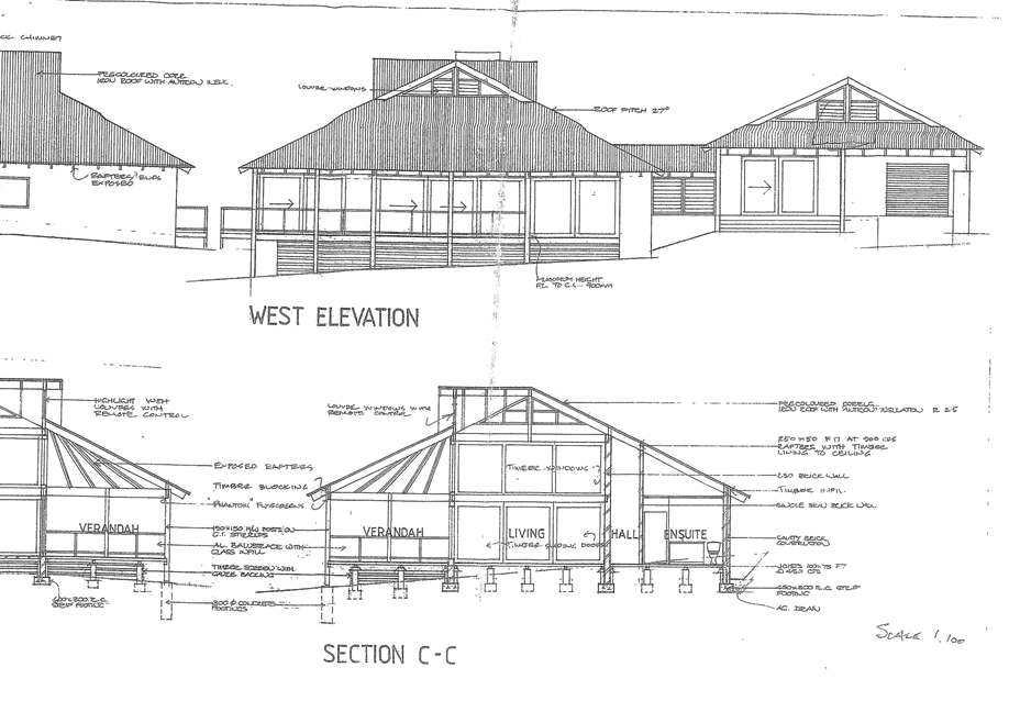
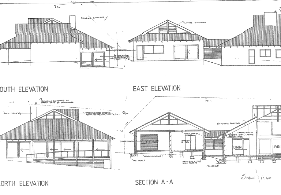
Attachment c Crown Lands Correspondence
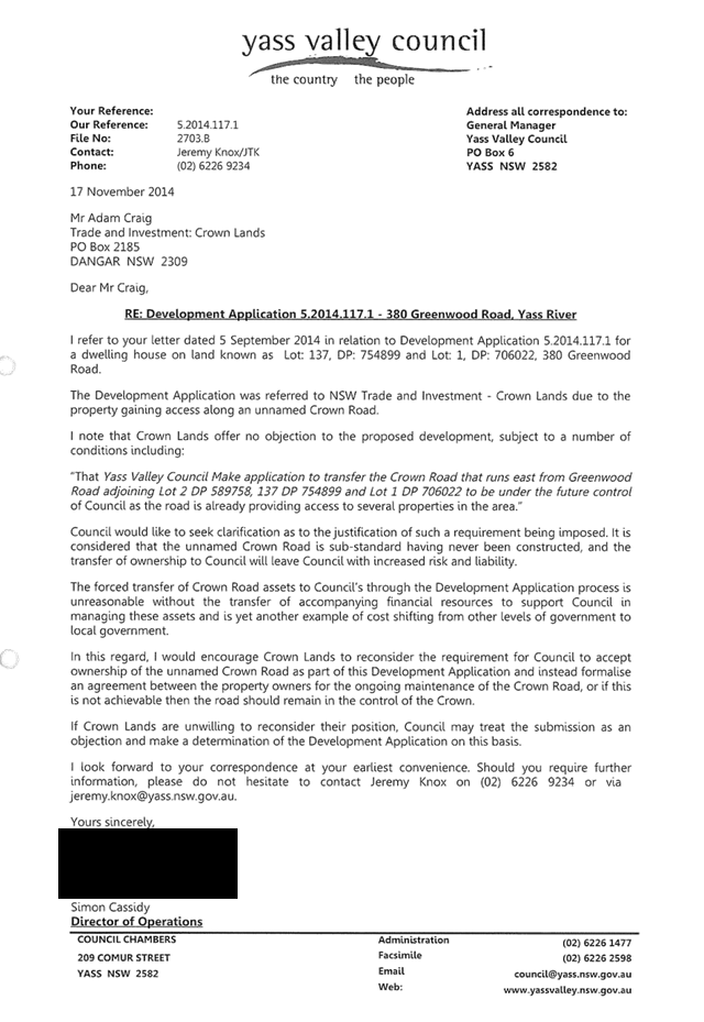
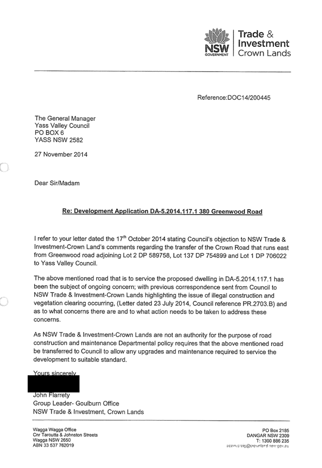
Attachment d Photographs
![]()
![]()
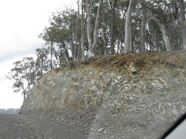
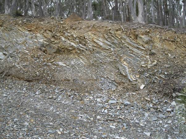
![]()
![]()

Attachment e Draft Conditions
(1) Consent is granted generally in accordance with the plan(s) and details submitted to Council with the Development Application. The plan and details have been stamped and attached to this consent. The development shall be carried out in accordance with the stamped plans or as modified by these conditions;
(2) Work on any building shall not commence until a Construction Certificate, complying in all respects with the provisions of the Environmental Planning and Assessment Act 1979, Environmental Planning and Assessment Regulation 2000 and the Building Code of Australia, has been issued.
Note: A Construction Certificate Application has not been lodged with Council.
(3) This approval relates only to the development referred to in the development application and specifically does not amount to an approval or acceptance by the Council of any works or buildings already erected on the land, whether or not those works or buildings are the subject of a prior development or building approval;
(4) The capacity and effectiveness of runoff and erosion control measures shall be maintained at all times to the satisfaction of Council as shall any techniques to suppress dust and the tracking of sediment onto existing sealed roads;
(5) All adjustments to existing utility services whether caused directly or indirectly by this proposed development are to be undertaken at the developer’s expense;
(6) The colours and external materials used are to be of such a nature to be compatible with those of existing development in the locality.
Note: Reflective materials (i.e. zincalume and surf mist) are not permitted;
(7) Adequate public road access shall be provided to the requirements of Crown Lands.
Note: In the absence of any roads standards specified by Crown Lands the standard of construction shall be in accordance with Council requirements
PART B - PRIOR TO ISSUE OF CONSTRUCTION CERTIFICATE
(1) The applicant shall submit to the Principal Certifying Authority, a copy of an Owner Builder Permit or Home Owner’s Warranty Insurance for the proposed development;
(2) Structural drawings prepared by a suitably qualified and experienced Structural Engineer being submitted to and approved by the Principal Certifying Authority prior to the issue of a Construction Certificate. The plans shall detail:
(a) All reinforced concrete floor slabs and/or beams or raft slab (having due regard to the possible differential settlement of the cut and fill areas where applicable);
(b) Footings of the proposed structure;
(c) Structural steel beams/columns;
(3) The applicant shall submit to the Principal Certifying Authority, manufacturer’s specifications for the proposed solid fuel heater;
(4) The applicant shall submit details for the construction of the public road access to the requirements of Crown Lands.
Note: In the absence of any requirements specified by Crown Lands the following will apply:
(a) A report prepared by a suitably qualified geotechnical engineer is to be provided to Council. The report is to consider the stability and safety of the cut and fill batters along the length of the unnamed Crown Road, and make recommendations for remediation measures to ensure the ongoing safety and stability of the road embankment and batters. Consideration is to be given to site drainage as well as constraints such as property boundaries and native vegetation in determining proposed remediation measures;
Note: Irrespective of any approval given by Council, a current tenure is required from NSW Trade & Investment: Crown Lands authorising such work.
(b) Engineering Drawings associated with the design of a culvert at approximate chainage 700m is to be provided to Council for approval. The design shall be undertaken by a suitable qualified engineer and designed in accordance with Council policy, Council’s Design and Construction Specification - AusSpec#1, and relevant standards;
Note: Irrespective of any approval given by Council, a current tenure is required from NSW Trade & Investment: Crown Lands authorising such work.
PART C - PRIOR TO COMMENCEMENT OF WORK
(1) Council shall be informed of the name and details of the Principal Certifying Authority and the date construction work is proposed to commence, no later than 2 days prior to such commencement;
(2) Appropriate soil erosion and sediment control measures shall be installed;
(3) A sign shall be displayed in a prominent position on any site on which building, work, subdivision work or demolition work is being carried out.
The sign must list the following details:
Ø The name, address and telephone number of the Principal Certifying Authority; and
Ø The name of the Principal Contractor and an after hours telephone number; and
Ø That unauthorised entry to the site is prohibited.
The sign must be maintained while the building work, subdivision work or demolition work is being carried out and removed upon completion;
(4) Public access to the site and building works, materials and equipment on the site is to be restricted, when building work is not in progress or the site is unoccupied.
Note: The public safety provisions must be in place prior to the commencement of any demolition, excavation or building works and be maintained throughout construction;
(5) Toilet facilities must be provided at the work site on which work involved in the erection or demolition of a building is being carried out. Each toilet provided must be:
a) a flushing portable toilet maintained under a service agreement with an accredited service provider; or
b) a standard flushing toilet connected to a public sewer; or
c) a standard flushing toilet connected to an accredited on-site sewage management facility approved by Council;
(6) The building(s) shall be set out by a registered surveyor to verify the correct position of each structure in relation to the property boundaries;
(7) Any contractor undertaking works in a Council road reserve shall be recognised by Council as an “Approved Contractor” for such works.
The contractor shall submit the following details to Council not less than three (3) days prior to works commencing in the road reserve:
(a) A current public liability certificate with a minimum cover of $20mil.;
(b) Current plant / vehicle insurances;
(c) A certified traffic control plan for the proposed works.
PART D – BUILDING INSPECTIONS
(1) A critical stage building inspection must be carried out by the Principal Certifying Authority (or another Certifying Authority if agreed by the Principal Certifying Authority except for the final) at the following stages of construction:
|
Inspection |
Hold Point |
|
|
(a) After excavation of footings
|
Prior to pouring concrete; |
|
|
(b) Bearers and Joists |
Prior to placement of floor sheeting;
|
|
|
(c) Floor slab, |
Prior to pouring concrete,
|
|
|
(d) Frame/Pre-sheet |
Prior to placing internal sheeting, after all internal services including water plumbing and electrical are installed and external cladding has been fixed;
|
|
|
(e) Waterproofing of wet areas |
Prior to the placement of tiling and/or covering;
|
|
|
(f) External drainage and stormwater |
Prior to backfilling or covering pipes and connections to services;
|
|
|
(g) Interim Occupation |
Building completed with minor works outstanding – able to be occupied;
|
|
|
(g) Final |
All works relating to the proposed development are complete and all conditions of development consent are complied with. |
|
It is advised that any Certifying Authority is unable to issue an Occupation Certificate unless all critical stage inspections have been carried out (Section 109 E (3) (d) of the Environmental Planning and Assessment Act 1979);
(2) As the local Water and Sewer Authority Yass Valley Council must undertake inspections at the following stages of construction:
|
Inspection |
Hold Point |
|
|
(a) All internal and external drainage. |
Prior to backfill;
|
|
|
(b) All internal hot and cold plumbing works.
|
Prior to the installation of insulation and internal linings;
|
|
|
(c) Subsurface land application area and/or surface drip line prior to backfill or covering.
|
Prior to backfill or covering;
|
|
|
(d) Inspection prior to use of the system.
|
At point of commissioning of the system. |
|
|
(e) At the completion of all plumbing works. |
Prior to the occupation of the dwelling; |
|
(3) Yass Valley Council must undertake inspections at the following stages of construction:
|
Inspection |
Hold Point |
|
|
(a) Completion of culvert and any remediation works; |
Upon completion of the culvert and any remediation works.
|
|
|
(b) Completion of the intersection upgrade (from Greenwood Road);
|
Upon completion the completion of Greenwood Road intersection and prior to the occupation of the development.
|
|
Note: The fee per inspection shall be levied in accordance with Council’s Management Plan, relevant at the time payable;
(4) Upon inspection of each stage of construction, the principal certifying authority (or other suitably qualified person on behalf of the principal certifying authority subject to the provisions of the Environmental Planning and Assessment Act 1979 and Regulation 2000) is also required to ensure that adequate provisions are made for the following measures (as applicable), to ensure compliance with the terms of Council’s approval:
a) Sediment control measures.
b) Provision of perimeter fences or hoardings for public safety and restricted access to building sites.
c) Maintenance of the public place free from any unauthorised materials, waste containers or other obstructions.
(5) Roof truss and wall bracing details are to be supplied to the Principal Certifying Authority prior to frame inspection.
PART E – CONSTRUCTION
(1) All building work shall be carried out in accordance with the provisions of the Building Code of Australia (as amended) and all relevant Australian Standards;
(2) Noise generated during construction of the proposed development shall comply with the provisions of the Protection of the Environment Operations Act, 1997;
(3) To prevent water from entering the building, the floor level shall be a minimum of 225 mm above finished ground level. Seepage and surface waters shall be collected and disposed of without nuisance to adjoining properties;
(4) Timber framing shall be in strict accordance with the National Timber Framing Code AS 1684;
(5) Roof trusses must be installed in strict accordance with the manufacturer’s specifications;
(6) All plumbing and drainage work shall be in strict accordance with Australian Standard 3500;
(7) A properly constructed drain shall be placed in such a position as to divert all surface water runoff clear of the building area and all footings;
(8) Stormwater from roof areas shall be linked to a Council approved disposal system immediately before placement of any roofing materials;
(9) Smoke alarms must be located and installed in accordance with the Building Code of Australia.
Note: The Building Code of Australia requires smoke alarms to be hard wired and interconnected;
(10) All construction waste associated with any demolition and construction work shall be separated into components of:
Ø Asbestos;
Ø Clean fill;
Ø Bricks, tiles, concrete;
Ø Steel;
Ø Other metals;
Ø Timber & vegetation; and
Ø Other material.
Any asbestos shall be handled, removed and wrapped in accordance with relevant regulations and WorkCover directions and taken to Murrumbateman Landfill. Two days notice of delivery is required.
Fill shall be taken to either Gundaroo Landfill or Murrumbateman Landfill. All other material may be taken to either Yass Transfer Station, Gundaroo Landfill or Murrumbateman Landfill and deposited in the appropriate separated pile;
(11) To minimise soil erosion and sediment movement during construction, the following measures shall be implemented:
a. Removal and/or disturbance of vegetation shall be confined to the basal area of the approved building, the site of permanent accessways, and land extending a maximum of three (3) metres beyond the outermost projection of the approved building.
b. Topsoil stripped from the construction site shall be stockpiled and protected from erosion until re-use during landscaping.
c. Stockpiles of construction and landscaping materials, and of site debris shall be located clear of drainage lines and in such a position that they are within the erosion containment boundary or are equivalently protected from erosion and do not encroach upon any footpath, nature strip or roadway.
d. Final site spoil shall be disposed of to the satisfaction of Council.
e. Trenches shall be backfilled, capped with topsoil and compacted to a level at least 75mm above adjoining ground level.
(12) The proposed building is to be protected from the infestation of termites in accordance with the Building Code of Australia and AS3660.
Note: Upon completion of the building work, a durable notice must be permanently fixed to the building in a prominent location, such as a meter box or the like, indicating:
a) the method of protection;
b) the date of installation of the system;
c) where a chemical barrier is used, its life expectancy as listed on the National Registration Authority label; and
d) the installer’s or manufacturer’s recommendations for the scope and frequency of future inspections for termite activity.
(13) The Solid Fuel Heater must be installed on a non-combustible hearth in accordance with the Building Code of Australia or as specified by the manufacturer;
(14) The Solid Fuel Heater must be installed in strict accordance with the manufacturer’s specifications, in particular, safety clearances and flue installation, as required by AS.2918 Domestic Sold Fuel Burning Appliances – Installation;
(15) The Solid Fuel Heater shall be installed by a suitably licensed and/or experienced tradesman.
PART F – ON-SITE SEWAGE MANAGEMENT FACILITY
(1) The Septic Tank shall be located no closer than 3 metres from any building, 10 metres down slope from any in-ground rainwater storage tank, and 3 metres down slope from any above-ground rainwater storage tank;
(2) The Septic Tank and disposal area shall be protected from damage by vehicular traffic and stock;
(3) All stormwater and seepage from higher levels shall be diverted from the disposal area by a suitable drain;
(4) The Highland Tanks Pty Ltd Septic Tank and 40m2 absorption trench shall be installed in strict accordance with the Onsite Effluent Dispersal Investigation report prepared by Peter Fogarty of Soil and Land Conservation Consulting;
(5) All plumbing and drainage work shall be in strict accordance with Australian Standard 3500;
(6) Land application systems for effluent disposal must be greater than 40 metres from any dam, 70 metres from any non-potable bore, 250 from any potable bore, 100 metres from any watercourse and no closer than 15 metres from any residence;
(7) The Highland Tanks Pty Ltd Septic Tank shall be installed and maintained in strict accordance with NSW Health Certificate Accreditation No: 005-20582.
PART G – BUSHFIRE PROTECTION
(1) Water, electricity and gas are to comply with Section 4.1.3 of “Planning for Bush Fire Protection 2006”.
(a) Prior to the use of the development the following active firefighting systems shall be implemented:
· A dedicated water supply with a minimum capacity of 20,000 litres is required for firefighting with a 65mm Storz fitting and ball valve attached;
Note: Water supply tanks in bushfire prone areas must be non-combustible (I.e. Metal or Concrete).
· Provision of a 65mm Storz coupling with gate or ball valve to be located adjacent to the development access road and within the Inner Protection Area. This coupling shall be connected to the dedicated water supply and it is preferable that it is not located within 10m of the dwelling;
Note: See separate note on locating coupling point.
· Provision of petrol or diesel driven pump or gravity feed system connected to the dedicated static water supply. 3kW (5Hp) firefighting pumps are adequate for most domestic firefighting systems;
· Provision of taps and at least two hoses (with a minimum diameter of 18mm) such that all parts of the built assets within the development can be reached;
· All plumbing from the dedicated water supply, to and including the standpipe and ball valve shall be a minimum of 50mm;
· Delivery line to be buried a minimum of 300mm below finished ground level;
· There shall be a 50mm ball valve and a 50mm non return valve inserted into the delivery line at the outlet point from the tank containing the 20,000 litres dedicated water supply. This is to facilitate constant “prime” of the delivery line;
(2) Property Access Roads shall comply with Section 4.1.3 (2) of “Planning for Bush Fire Protection 2006”;
(a) Access from the road/property boundary to the development shall be constructed and maintained to the following design criteria:
· Minimum trafficable width of 4m with an additional 1m wide strip on each side of the road kept clear of bushes and long grass;
· Minimum vertical clearance of 4m to any overhanging obstructions, including tree branches, over carriageway;
· A fuel reduced zone shall be maintained for a distance of 5m each side of the 6m wide access road;
· The capacity of road surfaces shall be sufficient to carry a fully loaded firefighting tanker. (approx 15 tonnes);
(3) New construction is to comply with Appendix 3 -Site Bush Fire Attack Assessment of “Planning for Bush Fire Protection 2006”. In this regard the following design standards for construction are to be incorporated into the development:
(a) New construction on the eastern elevation shall comply with Sections 3 and 7 (BAL 29) Australian Standard AS3959-2009 'Construction of buildings in bush fire-prone areas' and section A3.7 Addendum Appendix 3 of 'Planning for Bush Fire Protection';
(b) New construction on the northern, southern and western elevations shall comply with Sections 3 and 6 (BAL 19) Australian Standard AS3959-2009 'Construction of buildings in bush fire-prone areas' and section A3.7 Addendum Appendix 3 of 'Planning for Bush Fire Protection';
(c) Roofing shall have leafless guttering (gutter guard) to prevent the build up of flammable material. Any materials used shall have a Flammability Index no greater than 5;
(4) At the commencement of building works and in perpetuity the property around the building shall be managed as follows as outlined within section 4.1.3 and Appendix 5 of 'Planning for Bush Fire Protection 2006' and the NSW Rural Fire Service's document 'Standards for asset protection zones':
Ø North for a distance of 43 metres as an asset protection zone;
Ø East for a distance of 25 metres as an asset protection zone.
Land to the south and west has been classified as 'managed land' as vegetation considered to be a bush fire threat is at a distance of greater than 100m from the proposed dwelling and therefore have not been conditioned with an APZ;
(5) Landscaping should be undertaken in accordance with Planning for Bushfire Protection 2006.
PART H – CROWN LANDS
(1) Irrespective of any development consent or approval given by other public authorities, any work or occupation of Crown land cannot commence without a current tenure from NSW Trade & Investment: Crown Lands authorising such work and occupation;
(2) No materials shall be dumped or stored on Crown land/Crown roads;
(3) Public access on the Crown land shall be retained and not restricted on and along the Crown land;
(4) The development shall be undertaken in a manner that involves minimal environmental disturbance to the Crown land and shall avoid the removal or damage of native trees located within the Crown land;
(5) Measures should be taken by the applicant to ensure that the works do not contribute to the spread of noxious weeds. Should any noxious weeds or other environmental hazard be present on the site, NSW Trade and Investment: Crown Lands must be immediately informed and the appropriate advice on management sought.
PART I - PRIOR TO ISSUE OF ANY CERTIFICATE OF OCCUPANCY
(1) The premises shall not be occupied until all conditions and requirements of BASIX Certificate Number: 548101S have been complied with in accordance with the provisions of the Environmental Planning and Assessment Act, 1979, and Regulation, 2000.
Note: All critical stage inspections must be carried out in accordance with Section 109E(3)(d) of the Environmental Planning and Assessment Act, 1979 prior to the issue of any Occupation Certificate;
(2) The applicant is to certify that all measures required to achieve compliance with BASIX Certificate Number: 548101S have been installed in the dwelling;
(3) All retaining walls or other approved methods of preventing the movement of the soil must be completed prior to the issue of any Interim Occupation Certificate;
(4) Potable water supply storage shall be provided on-site to the following minimum standard:
Ø 45,000 litres for houses less than 150 m2 ;
Ø 90,000 litres for houses in excess of 150 m2.
Above ground tanks shall provide for the refilling of fire tankers by the installation of a “Storz” fitting at the base of the tank with a gate valve. The house service may branch off this outlet. Underground tanks shall include an access hole at least 150mm diameter;
(6) A Certificate of Compliance prepared by the installing tradesman shall be submitted to Council and a final inspection shall be conducted prior to the utilisation of the Solid Fuel Heater;
(7) A Commissioning Certificate from the installation company shall be submitted to Council, verifying the land application system for effluent disposal, has been installed in accordance with the manufacturer’s specifications;
(8) The applicant is to certify that all measures required to achieve the standard for construction specified in PART G (having due regard to Planning for Bushfire Protection 2006 and AS 3959 “Construction of Dwellings in Bushfire Prone Areas”) have been completed;
(9) Lot: 137, DP: 754899 and Lot: 1, DP: 706022 shall be consolidated into a single allotment. Evidence of the consolidation having been registered at the Land Titles Office shall be submitted to Council;
(10) A Right of Way shall be created over the existing track located on Lot: 137, DP: 754899 to provide legal access to Lot: 96, DP: 754899;
(11) The applicant is to complete all works associated with the recommendations of the geotechnical report, and/or other road remediation;
(12) A culvert is to be constructed at approximate chainage 700m in accordance with the approved construction certificate plans;
(13) The intersection between the unnamed Crown Road and Greenwood Road shall be constructed and maintained as a ‘Rural Property Access’ to the following minimum standards:
(a) Safe Distance Requirements in accordance with Section 7 of Council’s Roads Standards Policy RD-POL-09;
(b) The access shall be constructed to “Rural Property Access –with Indented Access” (see Appendix B of Council’s Road Standards Policy RD-POL-09) standard in accordance with Austroads Guide to Road Design – Part 4: Intersections and Crossings General, and be sealed from the edge of the Greenwood Road for 15 metres along the unnamed Crown road;
(c) The access is to be constructed with a minimum thickness of 100 mm. approved compacted gravel. Where the access is onto a sealed road pavement, then the entrance will also be provided with a two coat bitumen seal or 100mm thick concrete (25 MPA with SL72 mesh), or similar all weather pavement;
(d) Reinforced concrete pipes (minimum of 300 mm diameter) and headwalls are to be installed in the table drain in accordance with AS 3725. Pipe and headwall structures are to be set back a minimum of 2m from the edge of the road formation and be provided with permanent erosion protection upstream and downstream of the culvert. Pipes are to be designed for a minimum of a 1 in 5 year storm event or determined as follows:
|
Catchment Size |
Less than 0.5 Ha |
Less than 1 Ha |
Less than 2 Ha |
Less than 3 Ha |
3+Ha |
|
Pipe Size |
300 mm |
375 mm |
450 mm |
600 mm |
AR & R 1 in 5 year storm event. |
(e) Where a pipe culvert would be unsuitable, due to topography and pipe cover requirements, a reinforced concrete dish drain may be constructed in the table drain with the approval of the Director of Operations. Minimum requirements for the construction of a dish drain are as follows:
- minimum 150mm thick;
- 1.5m wide;
- dish drain to be constructed full width of the access, minimum 5 metres in length;
- 25MPa concrete with SL72 mesh;
- Permanent erosion protection upstream and downstream of the dish drain;
(f) The finished surface of any earthworks required for the access shall be graded to a maximum of 1 in 4 in cut, and 1 in 2 in fill;
(g) The surrounding soil shall be made flush with the new access and reseeded;
(h) Concealed entry signs must be installed and maintained on either side of Greenwood Road 70m in advance approaching the subject access;
Note: The required concealed entry signs are a standard Road Maritime Service (RMS) sign which display “CAUTION (Curved Symbol) DRIVEWAY’ (sign Number W2-206-2).
PART J - PRIOR TO ISSUE OF A FINAL OCCUPATION CERTIFICATE
(1) A Final Occupation Certificate will not be issued until all conditions of this consent have been complied with in accordance with the provisions of the Environmental Planning and Assessment Act, 1979, and Regulation, 2000;
(2) Prior to the issue of any Final Certificate of Occupancy, individual Certificates of Compliance are to be submitted to Yass Valley Council certifying that the following specialist work (as applicable to the development):
Ø Plumbing/drainage work
Ø Gas fitting work
Ø Electrical work
has been undertaken by a tradesperson licensed by the NSW Department of Fair Trading and complies with all relevant Australian Standards and the Building Code of Australia (as amended).
Note: A copy of the tradespersons license number, name, address and the Australian Standards to which the certificate relates is to be included on any Certificate of Compliance submitted to Yass Valley Council;
(3) The developer shall restore, replace or reconstruct any damage caused to road pavements, surfaces, street furniture, roadside drainage, street lighting or underground facilities as a result of the construction of the development.
NOTES ACCOMPANYING DEVELOPMENT CONSENT 5.2014.117.1
(Please read these notes carefully to ensure you are fully conversant with the conditions under which this consent is granted.)
(1) This consent has been granted under Clause 2.3 and 4.2B of Yass Valley Local Environmental Plan, 2013;
(2) All fees and charges associated with this consent shall be adjusted annually from the date of this consent in accordance with seasonal movements in the CPI for the Canberra region;
(3) Any additional Council inspection, beyond the scope of any Compliance Certificate package and needed to verify the compliance of any work, shall be charged at the individual inspection rate nominated in Council’s Fees and Charges Schedule;
(4) The applicant shall ensure all sub-contractors are licensed by the NSW Department of Fair Trading;
(5) Balconies more than 1 metre above ground shall be provided with a balustrade or other barrier that has minimum height of 1 metre, with balusters spaced at a maximum 125 mm;
(6) The stairwell is to have a minimum headroom height of 2 metres, going of 240 mm and maximum risers of 190 mm. Slope relationship (2R+G) shall be within the range of 550 mm – 700 mm;
(7) The Occupational Health & Safety Act, 2000, the Occupational Health & Safety Regulation, 2001 and various Australian Standards provide a comprehensive set of risk control measures and procedures for development sites which cover all types of risk. This legislation is administered by Workcover New South Wales which has produced a variety of guidelines and other supporting documents for the information of developers.
All persons undertaking work in connection with this consent should ensure that all required risk control measures and procedures are complied with.
(8) The location of the active firefighting system in relation to the dwelling must be;
· Accessible at all times;
· Located greater than 10 metres and less than 30 metres from the dwelling;
· Located adjacent to the access road to the dwelling;
· Located within the Inner Protection Area;
· Attached to a metal stand pipe 500mm minimum height above finished ground level;
· Appropriately painted with yellow reflective paint and have a blue reflective device affixed to the top of a support stake so it is clearly visible at night;
· In an area that is maintained cleared of all vegetation (except grass) for a distance of 1 metre all round.
(9) Crown Lands Advice
(a) This Consent does not imply the concurrence of the Minister of Natural Resources, Lands and Water for the proposed development, or the issue of any necessary lease, licence or other required approval under the Crown Lands Act 1989; and does not prevent the NSW Trade & Investment from making any submission commenting on;
(b) The Minister of Natural Resources, lands and Water reserves the right to issue landowner’s consent for the lodgement of applications for any other development proposals on the subject land concurrent with landowner’s consent;
(c) The Crown and the Minister for Natural Resources, Lands and Water are indemnified and kept indemnified against all claims arising out of the use and occupation of the Crown land in respect of the proposed development.
8.4 Asbestos Issues - Hume Park and Allen Park
FILE: PR1617 & PR001942 – CB
SYNOPSIS
To present a report on the status of the asbestos issues at Hume Park and Allen Park.
OPERATIONAL PLAN AND BUDGET IMPLICATIONS
Resources for compliance action are included in the Operational Plan
COMMUNICATION PLAN
Nil
SUSTAINABILITY IMPLICATIONS
|
Social |
Asbestos poses potential risks to public health |
|
Economic |
Asbestos contamination can impact on the effective use of land |
|
Environment |
Asbestos poses a potential risks to the environment |
|
Governance |
The Environmental Planning & Assessment Act 1979 and the Protection of the Environment Operations Act 1997 provide a compliance role for Council |
|
That the report on asbestos issues at Hume Park and Allen Park be noted and a further report be brought back to Council in the new year.
|
Attachments: Nil
REPORT
At its meeting on 26 November 2014 Council resolved that:
‘A report be brought back to the December 2014 meeting in relation to asbestos issues at Allen Park and Hume Park.’
The asbestos issues at Hume Park relate to illegal landfill operations while at Allen Park, Bowning they relate to a fire damaged building.
According to the WorkCover guidelines Managing asbestos in or on soil (March 2014) asbestos only poses a risk to human health when elevated levels of asbestos fibres are breathed in. The guidelines also indicated:
The likelihood of exposure occurring depends upon the potential for the asbestos material to release fibres, whether the asbestos material is contained or covered, and any operational control measures or personal protective equipment which have been applied to limit the generation and/or inhalation of airborne fibres.
Non-friable asbestos, previously referred to as ‘bonded asbestos’, in sound condition represents a low human health risk. However, friable asbestos materials or damaged, crumbling bonded asbestos, have the potential to generate, or be associated with, free asbestos fibres and therefore must be carefully managed to minimise the release of asbestos fibres into the air.
Guidelines for managing asbestos contaminated sites indicate that remediation options are preferred which minimise public risk, soil disturbance and also minimise the amounts of contaminated material that are removed to landfill. Management of asbestos in situ is encouraged, which may include covering the contamination with clean fill and/or other protective or warning layers. The common alternative of complete removal of asbestos from a site often involves extensive and costly investigative and confirmatory sampling and is sometimes not effective.
Hume Park
There are two compliance issues at the Hume Park site i.e.
· Unauthorised building works (retaining wall within the park)
· Illegal disposal of asbestos
Reports of asbestos being used as backfill for retaining walls at the site were reported in December 2008. Following a site inspection an independent structural engineering report was commissioned in relation to the building safety issues. This assessment did not deal with the asbestos matters.
The asbestos issues were determined to be of greatest concern so the focus of compliance action has been on this issue.
On 24 December 2008 the lessee of the site was directed:
· To prevent any further waste being buried on site
· To identify the areas where waste have been buried
In early 2009 there were discussions between Council staff and the lessee regarding how the issues would be managed and some indication that activities were being monitored by Council’s compliance staff. The Department of Environment & Climate Change also requested details of investigation work undertaken into allegations of non-compliance of asbestos disposal at the site. There are no records of any further action until 2012.
In February 2012 a plan identifying the location of alleged asbestos waste was prepared following further reports of asbestos at the site and in May 2012 assistance was sought from the Environmental Protection Authority (EPA).
The EPA subsequently advised that Council engage an Occupational Hygienist to assess the entire surface area where the asbestos is alleged to be deposited to ensure that there is no public health risk at that location.
In June 2012 a proposal from Robson Environmental was submitted to investigate the alleged contamination which was referred to the EPA for comment. By the end of August 2012 the project outline was finalised and Robson Environmental formally engaged on 5 September 2012.
In October 2012 the initial report from Robson Environmental made two key findings i.e.
1. The airborne fibre monitoring results were below the minimum practical detection limits. These results indicate that during the fieldwork undertaken at the site, it is unlikely that respirable asbestos fibres became airborne at detectable levels
2. In its current state the surface area of the investigation area is considered to pose an immediate risk to users of the site. Mitigation measures such as removal of the asbestos from the site should be undertaken as soon as possible
It is noted that the recommendation seems inconsistent with the guidelines which prefer for the material to be managed in situ.
In November 2012 a report of excavation and landfilling works being undertaken along the shoreline with no consent/approval was received. The Office of Water, State Water Corporation and EPA were notified and a joint inspection conducted was by the EPA and Council staff. On 8 November 2012 an Order was issued requiring:
· Works to cease
· Erosion and sediment control measures to be installed
· Approvals to be obtained
On 14 November 2012 the EPA confirmed the outcomes from the recent inspection and concluded that:
From observations made during the inspection, the EPA is satisfied that the lessee is not using soil material from the former landfill area to conduct the current earthworks in the foreshore area of the Park.
On 15 November 2012 Council and Office of Water staff inspected the site and confirmed access to the investigations areas was restricted by parawebbing and some construction fencing.
On 20 November 2012 a Direction to Take Clean-Up Action under the Protection of the Environment Operations Act 1997 was issued with action to be completed by 20 May 2013. This Direction stated that:
All excavated material, ‘waste’, waste tyres and asbestos-containing material are to be removed from the areas identified as follows:
· Investigation Area assessed by Robson Environmental Pty Ltd
· Excavation Site adjacent to the Trailer Parking Area
· Park Foreshore to the north east of the existing Boat Ramp
The Order was also reissued to cross reference the Clean Up Action Direction.
It is not clear what compliance action was taken throughout 2013 but in June 2014 an inspection was taken by Council staff and new directions were issued on 2 July 2014 which will expire on 5 January 2015.
In light of the Robson Environmental report and past Orders there is priority to manage the investigation areas in situ until some permanent arrangement is made. These areas should be clearly fenced off to restrict access with appropriate sites to inform why access is restricted. In addition the lessee should be requested to submit an action plan to outline how compliance with the Orders is to be achieved.
If the Orders are not complied with, then a further report will be brought back to Council indicating the options for removing the material or more permanently managing the areas in situ and mechanisms for passing these costs onto the lessee.
It is noted that there have been other recent reports of unauthorised building works at the site unrelated to the asbestos issue and these will continue to be addressed separately.
Allen Park, Bowning
The asbestos issues at Allen Park, Bowning have involved the following compliance action.
Council staff inspected the site on 6 January 2014 in response to reports of a fire. A large shed, stockyards and a dwelling all sustained significant damage as a result of the fire. The large shed and stockyards were in the process of being demolished at the time of the inspection. It was understood that emergency services were having difficulty completely extinguishing the fire within the dwelling. To assist in extinguishing the fire the dwelling was demolished leaving the subfloor of the building and a pile of fire damaged debris.
Whilst a review of Council’s records in relation to the date of construction of the dwelling was inconclusive, it was determined that there was potential for the home to contain asbestos material. This combined with the fact that the dwelling had sustained significant damage lead to the issuing an Order on 6 January 2014 for the demolition and removal of all the fire damaged buildings.
As a precaution, Council staff erected signs to warn visitors of the potential of asbestos being present on the site. Upon issuing the Order, the landowner expressed concern about being able to fund the clean-up.
The initial Order to demolish and remove the fire damaged building was not completed and no further action was taken until concerns were raised by the neighbour in September 2014. As a result the Order to demolish and remove the debris on site was reissued on 25 September 2014.
Along with several telephone calls the neighbour was sent a letter on 2 October 2014 explaining that the Order had been reissued and the risk to the public was considered to be extremely low. The Order gave a four week period for compliance and a commitment to keep the neighbour informed was reinforced.
Following receipt of a complaint on 8 October 2014 Council staff visited the site to find the landowner burning material without the necessary permits. The landowner was requested to stop burning material and the fire was subsequently extinguished by the Rural Fire Service.
During this inspection it became clear the landowner had been sorting the fire damaged debris on-site into piles of timber, steel, bricks, fibro sheet and other material. From this inspection the extent of potential asbestos on the site appeared to be restricted to the eaves linings of the dwelling and seemed to have remained in a bonded or non-friable form. The measures taken remained precautionary as there was still no confirmed evidence that asbestos is present on-site.
In late October 2014 the landowner contacted Council staff to indicate he was unable to comply with the Order. Staff were informed that negotiations for the sale of the land were underway. Discussions between the prospective purchaser and staff indicated a strong commitment to have the issue resolved, at which point simply extending the Order to allow this to transpire was considered. Unfortunately to date the sale has not taken place and ultimately there are no guarantees it will.
Council has continually contacted the neighbour to keep him informed of developments with the site. The most recent correspondence was on 4 December 2014 to indicate the matter would be reported to Council.
The neighbour has consistently disputed Council staff opinion that the site presents a low risk to the community. A Licensed Asbestos Assessor has recently visited the site and has verbally confirmed that it poses a low risk, reaffirming the staff assessment. At this stage it is not considered necessary for any further independent assessment to be commissioned.
Given the nature of the risk associated with the remaining debris on-site and taking into account the negotiations concerning the sale of the site it is recommended that the demolition Order be extended until March 2014 and that staff continue to work with the landowner to have the material removed. Should removal of the material within this time be unsuccessful then a further report will be brought back to Council indicating the options for removing the material and mechanisms for passing these costs onto the landowner.
Ordinary Council Meeting 17 December 2014
8.5 Draft Policy: Consolidation of Lots
FILE: P.05.00.00 – CB
To present the outcomes from the public exhibition of the Draft Consolidation of Lots Policy
5.1.2.2 Develop and implement planning controls which guide the future built form of the rural townships whilst retaining large residential lots.
The draft policy was placed on public exhibition for wider community input.
|
Social |
Nil |
|
Economic |
Nil |
|
Environment |
Nil |
|
Governance |
The policy will be taken into account when considering Development Applications under the Environmental Planning & Assessment Act 1979 |
RECOMMENDATIONThat the revised Consolidation of Lots Policy be adopted.
|
Attachments: a. Submissions ⇩
b. Revised Consolidation of Lots Policy ⇩
At the 22 October 2014 meeting Council determined to place a draft Consolidation of Lots Policy on public exhibition for wider community comment.
Two submissions from the one person were received on the Draft Policy (refer Attachment A). In essence the submitter seeks to have alternate solutions to consolidation considered at both the Development Application stage and the request for modification stage. The draft policy has been revised to include this option (refer Attachment B).
The revised policy is suitable for adoption and provides a clear basis for assessing any Development Applications, requests to modify a Consent or review a determination.
Attachment b Revised Consolidation of Lots Policy
|
Title: |
CONSOLIDATION OF LOTS POLICY |
DA-POL-< > |
Service: DEVELOPMENT ASSESSMENT
Responsible Officer: DIRECTOR OF PLANNING
1. OBJECTIVES
· To detail when consolidation of lots will be required as part of any new construction proposal.
2. AREA OF APPLICATION OF THIS POLICY
This policy applies to the determination of applications and approvals under the Environmental Planning & Assessment Act 1979,
3. BACKGROUND
In many instances development has taken place on properties held in multiple titles by the same owner. In some case the development may be in close proximity to the common boundary and even built across this boundary.
Buildings should be confined to the lot upon which they are built with access to a public road and meet the appropriate fire separation requirements. This last point is important to minimise the spread of fire from one property to another.
Development that historically has been built on, near or across the common boundary may raise issues for new development (e.g. additions, alterations, extension) in relation to fire safety requirements under Part 3.7.1 Building Code of Australia (BCA) and clause 94 Environmental Planning & Assessment Regulation 2000.
As land is held in separate titles there is nothing preventing the land being separately sold without dealing with the encroachment/fire safety or access issues resulting in multiple parties inheriting the problem and potentially messy legal disputes.
Council has a responsibility to ensure fires safety requirements are not compromised, access is provided to a public road and a general duty to ensure problems are resolved as they are identified and before being passed on to subsequent owners.
4. POLICY STATEMENT
4.1 To ensure that fire safety requirements under the BCA and Environmental Planning & Assessment Regulation 2000 are addressed affected lots will be consolidated unless:
· The proposed development is not attached to or part of the existing structure that is over, on or near a lot boundary less than the required setback distance under the BCA to fire safety requirements and the proposed development meets the required setback requirements under the BCA; or
· An alternate solution is provided by an Accredited Certifier demonstrating compliance with the performance requirements of the BCA (eg boundary adjustment, fire rating the wall(s), other fire solution)
Where lots are not required to be consolidated an ADVISORY NOTE will be included in any Development Consent issued.
The following diagram details these circumstances:
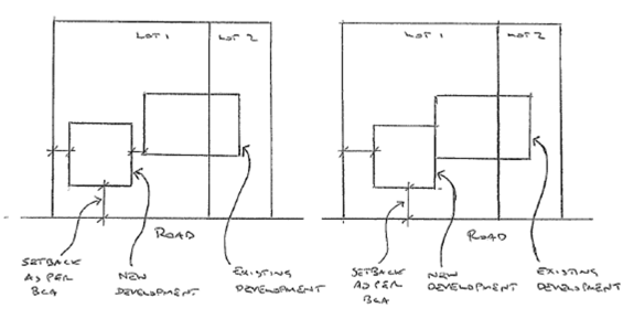
NO CONSOLIDATION REQUIRED CONSOLIDATION REQUIRED*
Note: The BCA specifies the setback distances relating to fire separation requirements. The Yass Valley LEP and/or DCP may specify additional setback requirements which may be for aesthetic or streetscape objectives rather than fire safety.
* Consolidation will not be required where an alternate solution is provided demonstrating compliance with the BCA for the existing development
4.2 In circumstances in which the requirement to consolidate has been overlooked, for whatever reason, then the requirement for the lots to be consolidated will be taken when a request for Consent modification is received provided that the applicant has been consulted prior to any decision being made.
As an alternative to consolidation in these instances Council will consider
1. Entering into an agreement for:
· Both lots to be held in the same ownership while ever the development remains on the land; and
· Consolidation is undertaken if the land is sold or if a new Development Application is received triggering the need for consolidation as outline in Section 4.1 whichever occurs first.
2. Accepting an appropriate title restriction for both lots to be held in the same ownership.
3. Other alternate solution prepared and endorsed by an Accredited Certifier
Note: In consulting with the applicant consensus or agreement on whether the land should or should not be consolidated is not necessary for a determination to be made. The particular circumstances of the case will be taken into account.
If the applicant is aggrieved by the decision made the options remain to seek a s82 Review under the Environmental Planning & Assessment Act 1979 or to appeal the decision to the Land & Environment Court.
4.3 Consolidation will not be required if the existing development, which encroaches over the common boundary or is less than the required setback under the BCA, is to be demolished.
4.4 Consolidation will not be required if the lot boundaries are realigned to ensure the existing building is on a single lot that complies with the required setbacks and all lots meet the minimum size, depth and frontage requirements.
4.5 Consolidation may be required for other purposes than fire safety e.g. to create legal access / road frontage for any ‘land locked’ lot.
HISTORY
|
Minute No |
Date of Issue |
Action |
Author |
Checked By |
|
|
22 Oct 2014 |
|
Chris Berry |
|
|
|
|
|
|
|
|
|
|
|
|
|
|
|
|
|
|
|
FILE: 111 – CB
To present a Draft Enforcement Policy for consideration (refer Attachment A).
Resources for development compliance are included in the current Operational Plan.
Proposed to place draft policy on public exhibition for wider community comment
|
Social |
N/A |
|
Economic |
N/A |
|
Environment |
N/A |
|
Governance |
Regulated responsibility under the Environmental and Local Government legislation |
RECOMMENDATIONThat the Draft Enforcement Policy be placed on public exhibition and if no significant objections are received the policy be adopted.
|
Attachments: a. Draft Enforcement Policy ⇩
b. Complaints Policy ⇩
c. Draft Enforcement Procedure ⇩
At its meeting on 26 November 2014 Council determined that the Draft Enforcement Policy be brought back to the December 2014 Council meeting with the Complaints Policy.
A copy of the Complaints Policy is included in Attachment B for information.
The current Enforcement Policy outlines the policy approach but this is largely ‘buried’ in operational procedure. No reference is made to available resources.
The existing policy document has been reviewed to separate policy from procedural matters. A revised policy and new operational procedure have been prepared (refer Attachments A and C).
The policy approach is based on:
· Determining whether or not investigation is warranted
· Identifying whether or not the matter is part of an existing compliance program/priority
· Assessing the risk to public safety or the environment to prioritise action
· Progressively escalating action (if necessary) to achieve compliance
Under the current Complaints Policy a complaint is defined as generally any formal expression of dissatisfaction with Council’s policies and procedures, quality of service or follow up communication. It includes dissatisfaction with the outcome of a decision, level or quality of service, the failure to adhere to a policy or a procedure or the behaviour of an employee or agent that can be acted upon. For example:
· Council’s current setback policy does not provide any flexibility to be varied
· My letters have not been responded to and my telephone calls have not been returned
· I am dissatisfied with the decision not to grade my road and the reasons provided by Council’s representative
· Council’s representative spoke to me rudely
The Complaints Policy includes the following timeframes for acknowledging and responding to these complaints i.e.
|
Timeframe |
Action |
|
Immediate |
Complaints lodged by phone and 'in person' will be acknowledged at time of receipt |
|
Within 1 day |
All complaints will be recorded in Council’s electronic document management system |
|
Within 10 days |
Written or electronic complaints - the staff member dealing with the complaint will provide acknowledgement and aim to give a timeframe for resolution of the matter where it is complex or requires investigation. |
|
Within 28 days |
Council will aim to address the full complaint or keep the complainant informed of progress. For long and complicated issues updates will be provided at periodic intervals with the interval determined by the nature of the issue. |
A complaint or report alleging a breach of environmental legislation is not a matter handled under the Complaints Policy.
The Enforcement Policy aims to provide a clear indication of the organisational approach to these compliance matters. The current Enforcement Policy indicates that complaints will be acknowledged in 7 days and a response provided in 28 days. This is inconsistent with the timeframes in the Complaints Policy outlined above.
Unfortunately this approach does not differentiate between the levels of risk involved. The revised Enforcement Policy aims to address this shortcoming i.e.
|
Risk |
Response |
|
Life threatening or serious risk to the environment |
Response as soon as practical |
|
Non-life threatening or non-serious risk to the environment |
Response within 10 working days |
|
Council identified priority |
Response as per program or plan |
Any complaints or allegations under the Enforcement Policy will be acknowledged immediately they are received and lodged within Council’s electronic document management system within one day for consistency with the Complaints Policy. These have now been incorporated into the Draft Enforcement Policy.
8.6 Enforcement Policy
Attachment a Draft Enforcement Policy
|
Title: |
ENFORCEMENT |
RAN-POL-5 |
Service: PLANNING & ENVIRONMENTAL SERVICES
Responsible Officer: DIRECTOR OF PLANNING
1. OBJECTIVES
The objective of this policy is to establish clear guidelines for the exercise of discretion in dealing with regulatory action about unlawful activity and to provide consistent responses
2. DEFINITIONS
Unlawful activity - means any activity or work that has been or is being carried out:
· Contrary to the terms or conditions of a Development Consent, approval, permission or other written authorisation from the Council
· Contrary to an Environmental Planning Instrument that regulates the activities or work that can be carried out on particular land
· Contrary to any legislative provision regulating a particular activity or work
· Without a Development Consent, approval, permission or the like
3. AREA OF APPLICATION OF THIS POLICY
This policy applies to the investigation and enforcement of complaints about unlawful activity or failure to comply with the terms or conditions of approvals and orders in Yass Valley including such matters as:
· Regulation of parking
· Control over animals
· Heavy vehicles
· Pollution control
· Food safety
· Public health and safety issues
· Unauthorised development including buildings
· Non-compliance with Development Consent conditions
· Dumping of waste
· On site wastewater management systems
· Tree/s removal
4. BACKGROUND
There are limited resources to undertake investigations into alleged illegal activities and enforcement.
Experience indicates that many matters can be satisfactorily resolved without formal enforcement. This will be the approach generally taken unless there is a significant risk to life or the environment.
Discretion will also be used to determine whether formal enforcement will be taken or not.
Allegations lodged by telephone or ‘in person’ will be acknowledged immediately at the time of receipt. The allegations will in turn be recorded in Council’s electronic document management system within 1 day.
Council will take a risk based approach to responding to allegations of illegal activity and enforcement i.e.
|
Risk |
Response |
|
Life threatening or serious risk to the environment |
Response as soon as practical |
|
Non-life threatening or non-serious risk to the environment |
Response within 10 working days |
|
Council identified priority |
Response as per program or plan |
Any complaints or allegations will be acknowledged immediately they are received and lodged within Council’s electronic document management system within one day.
Allegations will be initially assessed to determine if investigation is warranted. Investigations will not occur if:
(a) The matter has already been investigated and resolved
(b) Council has no jurisdiction
(c) The activity is determined to be lawful
(d) The complaint is trivial, frivolous or vexatious
(e) Too much time has elapsed between the activity and the complaint being received
(f) There is another appropriate agency to investigate the matter
For those matters warranting investigation those that are non-life threatening/non-serious risks to the environment will progressively escalate from ‘counselling’ through to formal enforcement options provided for in the relevant legislation if corrective action is not taken.
For life threatening/serious risk to the environment a stronger enforcement response will initially be taken to achieve corrective action.
Where it is established that investigation is warranted then the following guide details the initial enforcement response related to the level of risk the process e.g.
|
Issue |
Risk |
Initial Enforcement Response |
|
Annual Fire Safety Statement- non submission by owner |
Low |
Reminder letter |
|
Advertising signs without approval |
Low |
Letter |
|
Air pollution – smokey chimney |
Low |
Letter |
|
Commercial swimming pool not properly maintained |
Medium/High |
Warning Letter or Notice/Order |
|
Development/Activity without Consent/Approval or not in accordance with conditions · Minor development or old unauthorised development · Minor breach of condition/s · Risk to health and safety |
Low
Low Medium |
Letter
Letter Warning letter |
|
Dangerous building/awning |
High |
Emergency Order |
|
Deposit litter from vehicle |
Low |
Penalty Infringement Notice |
|
Deposit litter/Dumped rubbish |
Low |
Letter (if someone can be identified) |
|
Dangerous Dog/Attacking Dog/Restricted Dog |
High |
Penalty Infringement Notice |
|
Issue (cont) |
Risk (cont) |
Initial Enforcement Response (cont) |
|
Dogs roaming and/or unregistered |
Low |
Pick up and impound (subject to available resources) |
|
Dog nuisance |
Medium |
Letter |
|
Erosion & sediment control (no imminent risk of pollution) |
Low |
Letter |
|
Erosion & sediment control (risk of pollution) |
High |
Notice/Order |
|
Environmental damage of a significant nature |
High |
Notice/Order |
|
Fire hazard (Long Grass) |
Medium |
Letter |
|
Fire Hazard (Building Safety) |
Medium |
Warning Letter |
|
Food safety/hygiene matters |
High |
Warning Letter |
|
Livestock on public road |
Medium |
Attend site and make safe |
|
Noise pollution · Air conditioner* · Intruder alarm* · Musical instrument and sound equipment* · Power tools* · Motor vehicle on residential premises* · Use of refrigeration equipment fitted to motor vehicle* |
Low Low Low
Low Low
Low |
* Mandatory warning required by legislation |
|
Obstruction of road/public place involving safety. |
Low/medium |
Letter |
|
Parking offences |
Low |
As per Parking Patrol Program |
|
Pollution Incident (eg water) |
High |
Notice/Order |
|
Tree removal/damage |
Low |
Letter |
|
Swimming Pool fencing/gates/open |
Medium/High |
Warning Letter or Notice/Order |
If a complainant is dissatisfied with the enforcement action taken, the matter should be brought to the attention of the Director Planning & Environmental Services for review.
If the complainant is not satisfied with the response of the Director Planning & Environmental Services the complaint can be reviewed in accordance with Council’s Complaints Policy or referred to the NSW Ombudsman.
6. REFERENCE DOCUMENTS/LEGISLATION
Previously known as Policy ORD-POL-5
Code of Conduct
Independent Commission Against Corruption Act 1988
Local Government Act 1993
Environmental Planning & Assessment Act 1979
Protection of the Environment Operations Act 1997
Enforcement Guidelines for Councils – NSW Ombudsman 2002
HISTORY
|
Minute No |
Date of Issue |
Action |
Author |
Checked by |
|
|
26 July 2010 |
Written |
Paul De Szell |
EMT |
|
450 |
10 November 2010 |
Adopted |
|
Special Planning Committee Meeting |
|
246 |
13 June 2012 |
Amended |
Paul De Szell |
Special Planning Committee Meeting |
|
|
< > Dec 2014 |
Amended |
Chris Berry |
Council Meeting |
Attachment c Draft Enforcement Procedure
|
Procedure: |
ENFORCEMENT |
XXX-OP-X |
Service: Planning & Environmental Services
Responsible Officer: Director Planning & Environmental Services
1. OBJECTIVE
To outline the approach to implementation of Council’s Enforcement Policy
2. DEFINITIONS
As per legislation
3. DETAILS/PROCESS
3.1 Responsibilities
All Council staff who deal with enforcement legislation are responsible for following this procedure.
All notifications of alleged unlawful activity should be logged into Council’s ‘Customer Action Request’ system and directed to the Responsible Officer.
All standard enforcement action will be undertaken by an Authorised Officer in accordance with these procedures.
Non-standard enforcement action will be reviewed by the Director Planning & Environmental Services or General Manager prior to approving the approach for the Authorised Officer to follow.
3.2 Investigating unlawful activities
All allegations and complaints regarding unlawful activities will be managed as per Flowchart 1 below.
An initial assessment will be made (refer Checksheet 1) to determine whether or not investigation is warranted.
If a decision is made not to investigate a complaint, this decision will be recorded with the reasons for that decision and the complainant must be advised of the decision.
If investigation is warranted then a risk assessment will be undertaken (refer Checksheet 2) to determine the enforcement response.
The complainant will be informed of the enforcement response.
The process for managing these is outlined in Flowchart 1.
3.3 Programmed Inspections/Patrols
The following activities will have programmed inspections/patrols:
· Parking infringements
· Food/Health premises inspections
· Onsite Wastewater Management
· Fire safety
· Awnings
· Companion Animals
· Dumping Surveillance
These inspections/patrols (other than Companion Animals) will generally be scheduled to occur regardless of risk level and usually will involve a specific program indicating how resources will be deployed. Companion Animals matters will be involve a risk assessment before determining whether resources will be deployed.
The process for managing these is outlined in Flowchart 2.
3.4 Right of appeal
If a complainant is dissatisfied with the enforcement action taken by Council, the matter should be brought to the attention of the General Manager.
If the complainant is not satisfied with the response of the General Manager the complaint can be referred to the NSW Ombudsman.
3.5 Options for dealing with unlawful activity
Council’s authorised officers will try to use the quickest and most appropriate option to deal with unlawful activity wherever possible unless there is little likelihood of compliance with these options. Approaches to be considered include:
· Referring the complaint to an external agency for further investigation or prosecution
· Taking no action on the basis of a lack of evidence or for some other appropriate reason
· Counselling the subject of the investigation to educate them on the relevant Council requirements
· Negotiating with the subject of the investigation and obtaining some undertakings to address the issues of concern arising from the investigation e.g. an application for modification of Development Consent
· Referring the parties for mediation with the Community Justice Centre or alternatively for private mediation
· Issuing a letter requiring work to be done or the activity to cease in lieu of more formal action
· Issuing a Notice of Intention to Serve an Order or Notice under relevant legislation, followed by service of an appropriate Order or Notice e.g. s124-128Local Government Act 1993 (LG Act 1993), s121B Environmental Planning & Assessment Act 1979 (EP&A Act 1979), and the Parts 4.2-4.4 and 8.6 Protection of the Environment Operations Act 1997 (POEO Act 1997)
· Issuing a Notice requiring work to be done under appropriate legislation
· Starting proceedings in the Land & Environment Court for an Order to remedy or restrain a breach of the relevant Act or Regulation (s673 LG Act 1993, s 123 EP&A Act 1979).
· Seeking injunctions from the Land & Environment Court or the Supreme Court
· Issuing a Court Attendance Notice in the local court
· Issuing a Penalty Infringement Notice
· Taking proceedings for an offence against the relevant Act or Regulation (e.g. s691 LG Act 1993, s125 EP&A Act 1979, Chapter 5 POEO Act 1997).
· Carrying out the works specified in an Order at the cost of the person served with the Order.
· Taking any other action as determined by a relevant Act or Regulation.
All enforcement action will be monitored and a decision made in relation to non-compliance within 2 weeks of any deadline imposed.
3.7 Taking enforcement action
When deciding what enforcement action to take, Council’s Authorised Officers will consider the circumstances of each specific case. The approach will take into account the level of risk (determined in Checksheet 2) and the particular circumstances (as determined in Checksheet 3).
4. REFERENCE DOCUMENTS/LEGISLATION
Previously known as Policy ORD-POL-5
Code of Conduct
Independent Commission Against Corruption Act 1988
Local Government Act 1993
Environmental Planning & Assessment Act 1979
Protection of the Environment Operations Act 1997
Enforcement Guidelines for Councils – NSW Ombudsman 2002
HISTORY
|
Date of Issue |
Action |
Author |
Checked By |
|
|
|
|
|
|
|
|
|
|
|
|
|
|
|
|
|
|
|
|
CHECKSHEET 1 – WARRANT FOR INVESTIGATION
To determine whether a matter needs to be investigated the following checks shall be undertaken:
|
Question |
Yes |
No |
|
Has the matter already been investigated and resolved? |
|
|
|
Is the matter within the jurisdiction of Council? |
|
|
|
Is the activity determined to be lawful? · Is the activity permissible without Consent/Approval? · Is there an Approval/Consent already in place? · Is the work still in progress under an existing approval/Consent? |
|
|
|
Is the complaint trivial, frivolous or vexations? |
|
|
|
Has too much time elapsed between the activity and the complaint being received? |
|
|
|
If there another appropriate agency to investigate the matter? |
|
|
|
Is the matter part of a Programmed Inspection/Patrol? |
|
|
Based on the responses to the above questions the alleged illegal activity will / will not be inspected.
……………………………………………………………………..
Authorised Officer
Date:………………………….
CHECKSHEET 2 – RISK ASSESSMENT
To determine the level of risk:
|
Question |
Yes |
No |
|
Does the matter involve a threat to life or public safety? · Unsafe building issue? · Food safety issue? · Dangerous/attacking dog? · Livestock on a busy road? |
|
|
|
Is there likely to be a significant/serious pollution incident? |
|
|
|
Is there information indicating there is a wider community concern? |
|
|
|
Does the complaint indicate the existence of a: · Systemic problem? · Series of complaints? · Pattern of conduct? · Widespread problem? |
|
|
|
Has the complainant discussed the matter with the alleged offender? |
|
|
|
Is there any indication the matter is likely to escalate? |
|
|
|
Are there likely to be significant resource implications for the organisation? |
|
|
Based on the responses to the above questions the alleged illegal activity has a:
□ Low level risk
□ Medium level risk
□ High level risk
The response priority is:
□ Urgent / Immediate (same day)
□ As resources permit (within 10 working days)
……………………………………………………………………..
Authorised Officer
Date:………………………….
Where it is established that investigation is warranted then the following guide details the initial enforcement response related to the level of risk the process e.g.
|
Issue |
Risk |
Initial Enforcement Response |
|
Annual Fire Safety Statement- non submission by owner |
Low |
Reminder letter |
|
Advertising signs without approval |
Low |
Letter |
|
Air pollution – smokey chimney |
Low |
Letter |
|
Commercial swimming pool not properly maintained |
Medium/High |
Warning Letter or Notice/Order |
|
Development/Activity without Consent/Approval or not in accordance with conditions · Minor development or old unauthorised development · Minor breach of condition/s · Risk to health and safety |
Low
Low Medium |
Letter
Letter Warning letter |
|
Dangerous building/awning |
High |
Emergency Order |
|
Deposit litter from vehicle |
Low |
Penalty Infringement Notice if vehicle/person can be identified |
|
Deposit litter/Dumped rubbish |
Low |
Letter (if someone can be identified) |
|
Dangerous Dog/Attacking Dog/Restricted Dog |
High |
Penalty Infringement Notice |
|
Dogs roaming and/or unregistered |
Low |
|
|
Dog nuisance |
Medium |
Letter |
|
Erosion & sediment control (no imminent risk of pollution) |
Low |
Letter |
|
Erosion & sediment control (risk of pollution) |
High |
Notice/Order |
|
Environmental damage of a significant nature |
High |
Notice/Order |
|
Fire hazard (Long Grass) |
Medium |
Letter |
|
Fire Hazard (Building Safety) |
Medium |
Warning Letter |
|
Food safety/hygiene matters |
High |
Warning Letter |
|
Livestock on public road |
Medium |
Attend site and make safe |
|
Noise pollution · Air conditioner* · Intruder alarm* · Musical instrument and sound equipment* · Power tools* · Motor vehicle on residential premises* · Use of refrigeration equipment fitted to motor vehicle* |
Low Low Low
Low Low
Low |
* Mandatory warning required by legislation |
|
Obstruction of road/public place involving safety. |
Low/medium |
Letter |
|
Parking offences |
Low |
As per Parking Patrol Program |
|
Pollution Incident (eg water) |
High |
Notice/Order |
|
Tree removal/damage |
Low |
Letter |
|
Swimming Pool fencing/gates/open |
Medium/High |
Warning Letter or Notice/Order |
CHECKSHEET 3 – ASSESSMENT OF CIRCUMSTANCES
|
Question |
Yes |
No |
Comments |
|
Has the Council created an estoppel situation?
|
|
|
|
|
Is the breach a technical breach only?
|
|
|
|
|
When was the unlawful activity carried out and for how long?
|
|
|
|
|
How has the unlawful activity affected the natural or built environment and/or the health, safety and amenity of the area? |
|
|
|
|
Would Consent have been given if it had been sought?
|
|
|
|
|
Can the breach be easily remedied?
|
|
|
|
|
Does the person in breach show contrition?
|
|
|
|
|
Are there any particular circumstances affecting the complainant or the person the subject of the complaint? |
|
|
|
|
Has the person the subject of the complaint received any previous non-punitive approach or has formal legal action been taken? |
|
|
|
|
Would an educative approach be more appropriate than a punitive approach? |
|
|
|
|
What are the costs and benefits of taking formal enforcement action as opposed to taking informal or no action? |
|
|
|
|
What action would be reasonable and proportionate in this case?
|
|
|
|
|
What would be in the public interest?
|
|
|
|
The recommended course of action is:
……………………………………………………………………………………………………………………………………………………………………………………………………………………………………………………………………………………………………………………………………………………………………………………………………………………………………………………………………………………………………………………………………………………………………………………………………………………………………………………………………………………………………………………
Authorised Officer …………………………………………………………….. Date……………………………………………..
FLOWCHART 1 – Allegation of Illegal Activity
![]()
FLOWCHART 2 – Programmed Inspections / Patrols
![]()
![]()
FLOWCHART 2A
![]()
FLOWCHART 2B
![]()
FLOWCHART 2C
![]()
Ordinary Council Meeting 17 December 2014
FILE: P.01.08.01 – SB
SYNOPSIS
Council previously adopted a playground strategy in 2007 and the vast majority of the goals and projects identified in the 2007 strategy have now been achieved. A revised strategy is now presented to Council for consideration.
OPERATIONAL PLAN AND BUDGET IMPLICATIONS
The Park & Playground Strategy 2014 addresses the following Strategies outlined in Council’s Community Strategic Plan 2013-2030:
4.2.1 Ensure that planning and provision of parklands and open space meets community needs
4.2.2 Develop specific plans of management for parklands and open space areas
4.2.3 Ensure that appropriate parkland is provided in new urban release areas
4.2.4 Ensure all playground infrastructure continues to meet Australian standards .
COMMUNICATION PLAN
It is proposed to place the strategy on public exhibition for a period of 28 days.
SUSTAINABILITY IMPLICATIONS
|
Social |
Playgrounds and the surrounding parks play an important role in the social environment for residents and visitors of the Yass Valley. |
|
Economic |
The projected costs included in the strategy are in line with the long term Asset Management forecast |
|
Environment |
Nil |
|
Governance |
The Playground Strategy is based on the requirements outlined in the Community Strategic Plan 2030 and provides for the management of playgrounds in accordance with current Australian standards. |
|
1. That the Playground Strategy 2014 be placed on public exhibition 2. That the Playground Strategy 2014 be adopted if no significant objections are received.
|
Attachments: a. Park and Playground Strategy 2014 ⇩
REPORT
1. Background
Council previously adopted a playground strategy in 2007 and the vast majority of the goals and projects identified in the 2007 strategy have now been achieved.
The Park and Playground Strategy 2014 identifies the standards for provision of playgrounds at various parks across the Yass Valley LGA and sets priorities for upgrading and replacement of Council’s playgrounds.
The document adheres to current Australian standards and is in line with Statewide Insurers best practice manual for management of risks associated with playgrounds.
The Park and Playground Strategy 2014 is designed to assist in achieving the goals outlined in the Community Strategic Plan 2030.
2. Playground Strategy
The Park and Playground Strategy 2014 guides the future development and maintenance of parks and playgrounds within the Yass valley. The key objectives of the document are;
· To provide a wide range of play opportunities within an accessible distance from residences
· To meet the needs of children through all stages of physical development
· To provide opportunities for both abled and disabled children
· To ensure that equipment complies with current safety standards and is appropriately maintained at all times.
The strategy identifies where key facilities are located and defines a hierarchy to ensure parks and playgrounds are developed sustainably and that adequate maintenance and renewal of park assets is able to be achieved. The strategy provides a priority list which if adopted will provide Council with priorities for renewal and upgrade of infrastructure as and when funding is available.
The Park and Playground Strategy 2014 has been provided as Attachment A.
9.1 Playground Strategy 2014
Attachment a Park and Playground Strategy 2014
Table of Contents
1. INTRODUCTION
2. BACKGROUND
3. OBJECTIVES
4. PLANNING ISSUES
4.1 Play Equipment
4.2 Associated Features
4.3 All Abilities Play Equipment
4.3 Siting
4.4 Vandalism
5. PLAYGROUND CATEGORIES
5.1 Park Hierarchy
5.1 Park Locations
6. INSPECTIONS AND MAINTENANCE
7. PLAYGROUND UPGRADE PROGRAM
7.1 Existing Playground Facilities
7.2 Park and Playground Priorities
8. LEVELS OF SERVICE
Yass Valley Council parks and playgrounds are some of the more essential recreational resources within the Local Government Area (LGA). Parks and playgrounds are more than places for children to play. They provide gathering areas for parents and carers, encouraging community interaction and providing children with opportunities for social and physical development.
Council aims to provide parks and playgrounds that are challenging, safe and fun for children of all ages. Currently, Yass Valley Council has 14 major parks and playgrounds, which are well distributed throughout the municipal area providing a range of varying play experiences. Other parkland and reserves exist throughout the LGA areas however are used for less organised leisure activities and generally contain no play equipment.
This strategy discusses not only play equipment, but also additional facilities that are an integral part of high quality play environments. Seats, picnic tables, bubblers, landscaping, surfacing material and edging not only make a playground more functional, but also makes it attractive and an enjoyable place to be for parents and carers.
It is intended that this document is a revision of the very successful Yass Valley Council’s Playground Strategy 2007. Ideally this strategy should be revised after 5 years.
2. BACKGROUND
Since 2003 Yass Valley Council has been implementing planned upgrades to existing park and playground facilities including the installation of four additional playgrounds. This work has ensured that playgrounds in the Yass Valley LGA meet current safety standards.
For the purpose of this plan, the term playground encompasses play equipment and features directly related to the playground, including soft fall material. Playgrounds are designed primarily to cater for children between the ages of two and twelve. They are valuable resources within the Yass LGA, and have an important function in the social and physical development of children, along with implications for community welfare.
The usage a park and playground receives is primarily associated with its location and the standard of play equipment available at the site. It is not financially possible to provide extensive play equipment at all sites, and as a result this strategy identifies a hierarchy of parks which aims to provide varying standards of parks dependent on likely usage at each site. People are more likely to travel greater distances to an open space area that offers a wide range of activities and experiences, and location of such facilities in central, easily accessible locations, promotes the use of these facilities by both residents and visitors to the area.
It is important to ensure that Council’s park and playgrounds are well managed and maintained in a manner that meets the needs and expectations of both residents and visitors to Yass Valley. Council has committed to the ongoing maintenance, enhancement and redevelopment of playgrounds within the Yass Valley, and this is assisted by the adoption of a hierarchy to ensure the ongoing sustainability of Council’s playgrounds.
3. OBJECTIVES
The following are Council’s objectives in the provision of parks and playgrounds:
· To provide a wide range of play opportunities within an accessible distance from urban residences;
· To meet the needs of children through all stages of physical development;
· To provide opportunities for both able and disabled children;
· To ensure that equipment complies with current safety standards and is appropriately maintained at all times;
4. PLANNING ISSUES
4.1 Play Equipment
This Strategy considers a long term policy and direction for:
(i) Play equipment and associated facilities.
(ii) The provision of adequate facilities for parents and carers supervising play activities.
(iii) The aesthetic appearance of play equipment and the park as a whole.
(iv) Acknowledging and providing play experiences for persons with disabilities
The strategy covers playground equipment as well as features directly related to the equipment including soft fall material, seats and tables, bubblers, fencing, lighting, pathways and landscaping.
Since 2003 the Yass Valley Council has made significant progress in the upgrading of old playgrounds and the installation of new facilities that meet current safety standards. Open spaces in Yass and the LGA are of high value to the community and attract much attention.
Council has a good reputation for the standard of its recreation facilities and to maintain this reputation, it is important to continue to plan for the replacement of aging playgrounds, and to plan for new open space and play facilities to address future growth.
4.2 Associated Features
In association with the ongoing provision of playgrounds across the LGA, it is recognised that there is a need to also install and maintain other facilities including amenities, seating, tables, bubblers, lighting, pathways and landscaping.
Seating: Facilities need to be made available to encourage the enjoyment of our park space by a large number of users. Seating plays an important part in this both as locations to rest and enjoy the park and for adults supervising children using the play equipment. Seating, including picnic tables need to be installed at playgrounds where facilities do not currently exist. The predominant type of seating (and table) facilities are high quality anodised aluminium which is both long lasting and vandal resistant. Any new table installations should take into consideration wheelchair accessibility.
Soft fall: Playground surfacing material has been installed in all of Yass Valley Council playgrounds in accordance with the Australian Standards. The standards relate to impact attenuation and fall zones, and require that soft fall is placed underneath and around all play equipment from which a child may fall, reducing impact. Preference is for playground bark, which provides a soft landing and is economical to install and maintain.
Fencing: Playgrounds in the Yass Valley LGA are generally not fenced off as they are considered part of the whole park space. Exceptions are where specific hazards have been identified which can be addressed by the installation of fencing.
There are currently three parks in the LGA that have fencing around or near the play equipment; Riverbank Park has a three sided fence to reduce immediate access to the river from the playground. Bowning Hall playground is fenced and Henry Lawson Park has a post and rail fence around the outside of the park space. Fencing in the immediate vicinity of a playground must be in good condition and be constructed of materials that are appropriate for use with children. Fences near playgrounds must meet the playground standards and be included in the operational inspection.
Landscaping: Landscaping features are integral parts of the overall design concept of a park. Landscaping can add another dimension to the park and playground by creating a visual appeal with specific effects including appealing fragrances, colours, textures and seasonal variations.
Bubblers: Category 1 parks such Riverbank Park and Coronation Park have installed bubblers. Banjo Paterson Park also has a bubbler unit due to the close proximity to the CBD and childcare facility. Other sites are generally not considered for Bubblers due to the lower level of usage and higher likelihood of vandalism.
Lighting: Council will aim to provide lighting for Category 1 playgrounds. Other sites will be assessed depending on potential risk and lighting considered on a needs basis.
Pathways: pathways provide linkage within parks and openspace areas. They are mostly provided within high usage park areas. These are required within all Category 1 Park areas as they have toilets, car parking, fitness tracks, or other buildings i.e. Visitor information centre.
4.3 All Abilities Play Equipment
Ideally Council would like to provide inclusive play experiences within parks and playgrounds that meet the needs of varying age groups as well as varying levels of mobility. It is recognised that this may not always be achievable due to funding constraints, however Council will strive to identify opportunities for more inclusive play equipment and attempt to source funding for its provision.
Council has undertaken consultation with a number of community groups and feedback indicates that Coronation Park would be a suitable and well utilised site for facilities such as a Liberty Swing. A Liberty Swing is a purpose built swing for wheel chair access and would provide opportunities for less able children to experience recreation opportunities which are limited in regional areas.
Opportunities for provision of such a facility will be pursued and it is recognised that there may be the possibility of joint funding such a project with either community groups or other service providers.
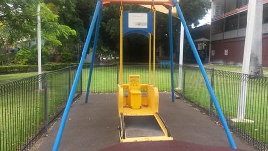
Image 1- Liberty Swing
4.3 Siting
The siting of playgrounds within parks is an issue to be considered when existing playgrounds are upgraded. Usually Council playground areas are custom designed to suit the site. Refurbishment is an opportunity to carry out a thorough site evaluation to ensure that the playground is positioned correctly within the park. Some issues to be considered are:
(i) Ease of access for all users from surrounding entrance points.
(ii) Location in relation to public amenities.
(iii) Views to all areas of the park and natural surveillance from surrounding areas.
(iv) Suitable distance from potential hazards such as roads or waterways, where possible.
4.4 Vandalism
Whilst Council does not have a significant vandalism issue, Council parks are periodically the subject of vandalism and antisocial behaviour. There are a number of key strategies that can be used to assist in reducing vandalism in community parks and playgrounds including the following:
(i) Encouraging community awareness and reporting of vandalism.
(ii) Installation of playgrounds and other equipment in locations which are visible and achieve natural surveillance from surrounding properties or other adjoining areas.
(iii) Actively seek to encourage community ownership of the playgrounds and facilities.
(iv) Install lighting in locations prone to vandalism; and
(v) Prompt removal of graffiti.
5. PLAYGROUND CATEGORIES
5.1 Park Hierarchy
The need to provide and maintain play equipment means that careful planning and location of facilities is required. Council will consider whole of life costs in planning for new playgrounds and park equipment to ensure that any facilities are financially sustainable in the longer term.
The following table provides the park and playground hierarchy and typical facilities that will be provided for each category of park:
|
Park Category |
Description |
Typical Playground Standard |
Typical Park Equipment |
Locations |
|
Category 1 |
Centralised park with diverse major play equipment, (population >5000)
|
- Large playground unit - Multiple pieces of equipment to cater for diverse age ranges -Softfall attenuation area to 250sqm |
-Table & seating -Signage -Lighting -Formalised gardens -Toilets -Formalised pathways -Tree plantings -Bins -Irrigation -Bubbler |
- Coronation Park Yass - Riverbank Park Yass |
|
Category 2 |
Neighbourhood park with varied equipment, (population 1500 – 5000 and Village population >100). |
-Small playground unit -Set of swings - Singular piece of equipment i.e. spring rocker -Softfall attenuation area to 150sqm |
-Table & seating -Bin -Lighting where applicable -Signage -Tree planting
|
- Henry Lawson Park - Banjo Paterson Park - John O’Brien Pk - Sutton Rec. Ground - Gundaroo Rec Ground - Binalong Rec Ground - Bowning Hall - Hercules St Murrumbateman - New Development areas at Hatton Park, Morton Ave, Fairley Estate and Hamilton Rise |
|
Category 3 |
Local park with a set of swings and spring rocker or equivalent (population <1500).
|
- Set of Swings - Singular piece of equipment i.e spring rocker -Softfall attenuation area to 100sqm |
- Seating - Signage - Tree planting - Bin where applicable |
- Jones Park Murrumbateman - Bookham Rec Ground - Townsend Place Yass |
Table 1 – Park Hierarchy
5.1 Park Locations
The approximate
location of each park and the relevant hierarchy category for each park are
shown in Figures 1 to 7 below:
Figure 1 - Yass
![]()
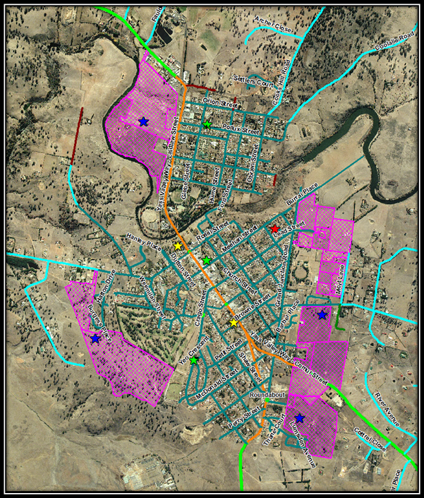
Figure 2 - Murrumbateman
![]()
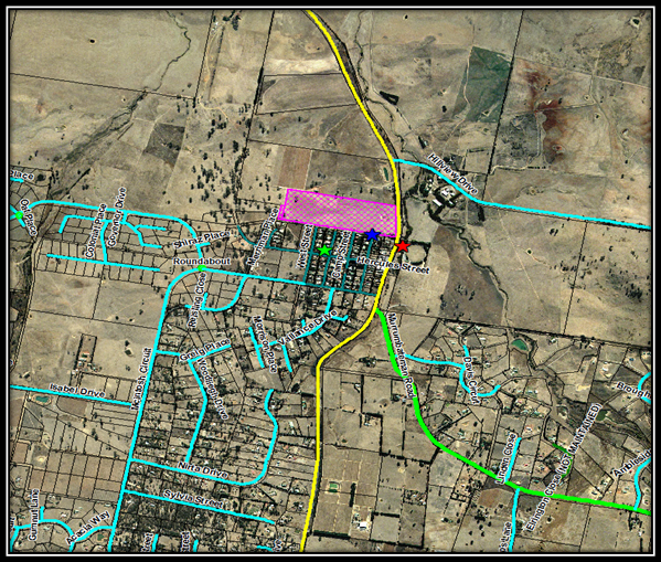
Figure 3 - Gundaroo
![]()
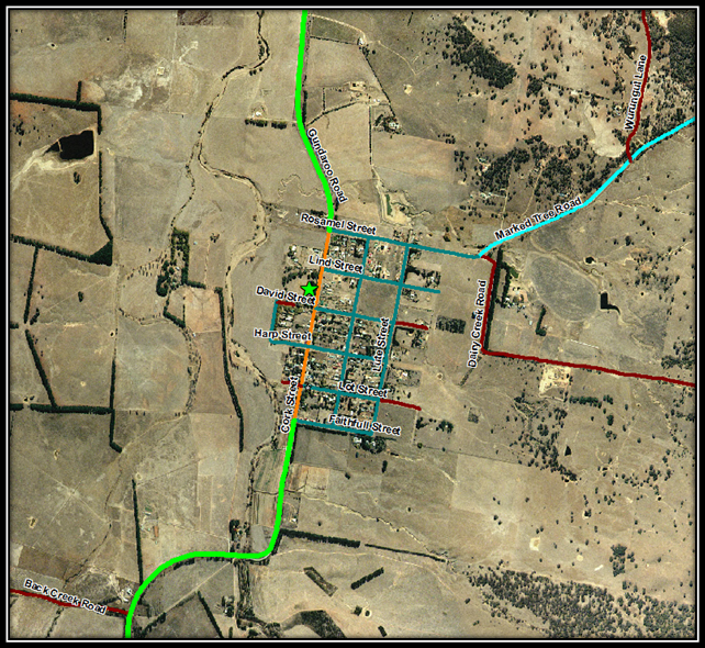
Figure 4 - Sutton
![]()
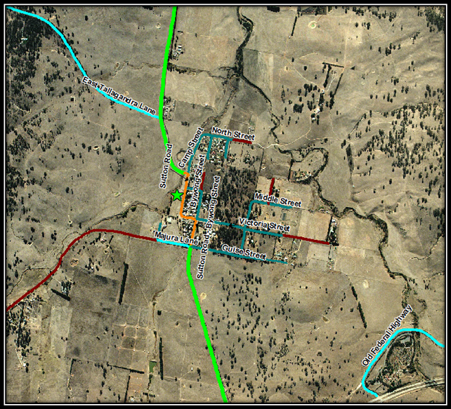
Figure 5 - Bowning
![]()
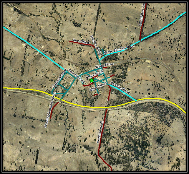
Figure 6 - Binalong
![]()
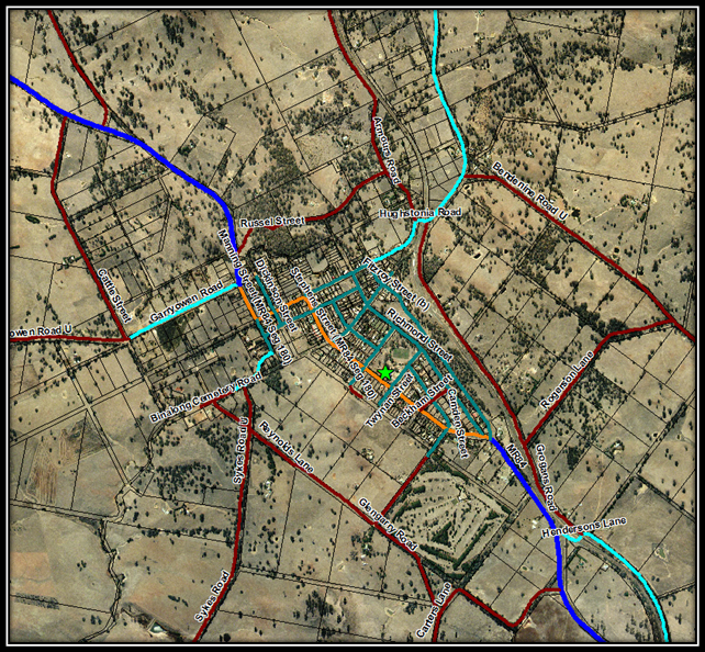
Figure 7 - Bookham
![]()
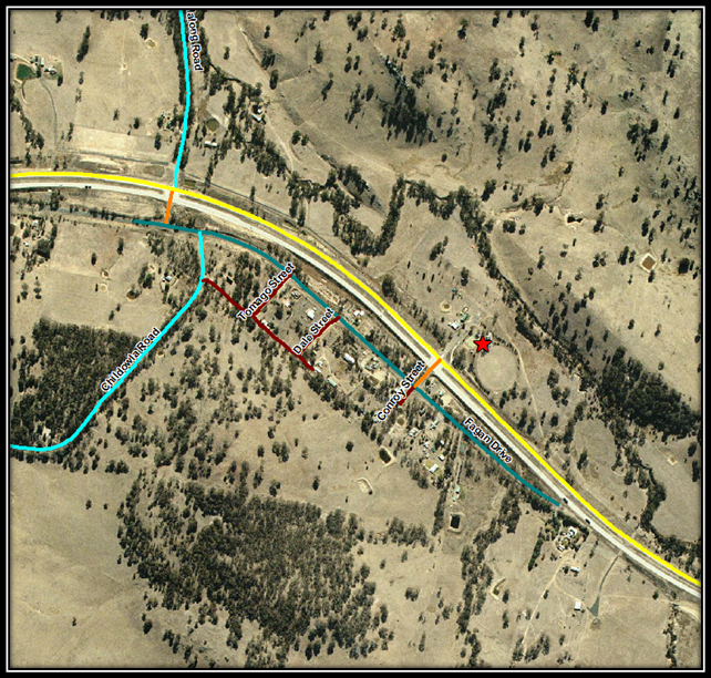
6. INSPECTIONS AND MAINTENANCE
There are four different types of inspection as detailed in the table below. For each of these inspections, the scope, complexity and frequency of the inspection varies. Council will ensure all playground inspections are undertaken by competent inspectors who are suitably trained and experienced.
|
Inspection Type |
Frequency |
Scope |
|
Routine |
Monthly |
This level of inspection identifies general maintenance issues associated with normal wear and tear, cleanliness, vandalism, or other routine maintenance requirements. |
|
Operational |
Annual |
This inspection checks the operation, stability and wear of equipment. |
|
Comprehensive |
Biennial |
This inspection checks the compliance of equipment with the safety standards, the overall safety of the equipment, foundations and surfaces. This inspection also assesses the compliance of any repairs made, added or replaced components and any new playground installations. |
|
Reactive |
As required |
Reactive inspections are conducted when issues are reported by the general public or Council staff. |
Table 2 – Park Inspection Schedule
Maintenance of playgrounds and public safety is a high priority for Council. Inspections of parks and playgrounds will be undertaken in accordance with the identified inspection frequency and will be recorded into Council’s electronic maintenance management system “Reflect”. Maintenance will be programmed based on the assessed risk of the specific issues identified during an inspection.
7. PLAYGROUND UPGRADE PROGRAM
The playground upgrade program is separated into two separate components as follows:
(i) existing playground facilities, and
(ii) new playground facilities.
The priority for upgrading existing playground facilities is reassessed annually, and takes into consideration a number of factors including:
· the age of the playground,
· inspection condition reports,
· the level of use, and
· community interest in the facility.
New playground installations relate to new development areas and are required to be provided by developers. The location and category of any playgrounds in new development areas will be determined based on the likely number of properties in any new development, and the proximity to existing playgrounds. Ideally Council aims to provide a playground within walking distance of each residential property where achievable.
Lifecycle asset management principals are utilised for park and playground equipment. This means that playgrounds that are installed are appropriately funded for maintenance and replacement over their 15 year lifespan. In some cases playgrounds that are in good serviceable condition after 15 years may be retained if no deterioration or safety concerns are recorded. Due to the significant lifecycle costs of a playground they can only be installed where specified. These are within a 1km radius of most residents within Yass and village areas
It is recommended that consideration be given to the installation of a Liberty Swing at one of our category one playgrounds. Coronation Park with its proximity to the Visitor Information Centre is an ideal location for the placement of a Liberty Swing that would be able to service local residents and visitors alike.
7.1 Existing Playground Facilities
The following table provides a list of current play equipment as at December 2014:
|
Park |
Location |
Category |
Equipment Type |
Date Installed |
|
Coronation Park |
Yass |
1 |
Playspace modular unit and swings |
2005 |
|
Riverbank Park |
Yass |
1 |
Forpark modular unit |
2009 |
|
Banjo Patterson Park |
Yass |
2 |
Playspace modular unit |
2000 |
|
Henry Lawson Park |
Yass |
2 |
Ausplay modular unit |
1992 |
|
John O'Brien Park |
Yass |
2 |
Moduplay unit |
2014 |
|
Townsend Place Park |
Yass |
3 |
Forpark stand-alone slide, swings and rocker |
2013 |
|
Hercules Street Playground |
Murrumbateman |
2 |
Forpark modular unit |
2009 |
|
Jones Park |
Murrumbateman |
3 |
Swing set |
1999 |
|
Binalong Rec. Ground |
Binalong |
2 |
Forpark modular unit |
2005 |
|
Bowning Hall |
Bowning |
2 |
Forpark modular unit |
2007 |
|
Bookham Rec. Ground |
Bookham |
3 |
Playspace swing set |
2005 |
|
Sutton Rec. Ground |
Sutton |
2 |
Forpark modular unit |
2008 |
|
Caravan Park renewal |
Yass |
2 |
Forpark modular unit |
2004 |
|
Gundaroo Rec. Ground |
Gundaroo |
2 |
Moduplay modular unit and swings |
unit: 1996 swings: 2006 |
Table 3 – Existing Play Facilities
7.2 Park and Playground Priorities
Yass Valley Council’s park and playground priorities will be reviewed annually as part of the Operational Plan process, taking into consideration the priority list identified in this document, condition of existing equipment, demands from new development and community input. The following table provides a prioritised list of projects for Council consideration as and when funds are available:
|
Priority |
Playground Site |
Estimated Cost |
Comments |
|
1 |
Coronation Park |
$ 30,000 |
Liberty Swing ( All abilities concept) |
|
2 |
Banjo Paterson Park |
$ 30,000 |
Playground Renewal. |
|
3 |
Riverbank Park |
$ 12,000 |
Irrigation for openspace near playground equipment |
|
4 |
Coronation Park |
$ 15,000 |
Park seating and shelter |
|
5 |
Gundaroo Rec.Ground |
$ 30,000 |
Playground renewal |
|
6 |
Caravan Park |
$ 30,000 |
Playground renewal |
|
7 |
Jones Park Murrumbateman |
$ 8,000 |
Jones Park: swings replacement |
|
9 |
Coronation Park |
$ 30,000 |
Playground renewal |
|
10 |
Henry Lawson Park |
$ 2,000 |
Park seating renewal |
|
12 |
Murrumbateman |
$ 30,000 |
Fairley Estate Cat 2 – timing related to development of area |
|
13 |
Hamilton Rise Estate |
$ 30,000 |
Cat 2 – timing related to development of area |
|
15 |
John O’Brien Park |
$ 20,000 |
New equipment/location. Time related to lower Walker Park improvements |
|
16 |
Hatton Park area |
$ 30,000 |
Cat2 – timing related to development of area |
|
17 |
Morton Ave area |
$ 30,000 |
Cat 2 – timing related to development of area |
Table 4 – Park & Playground Priority List
8. LEVELS OF SERVICE
It is important that our parks and playgrounds are adequately maintained to ensure an acceptable service standard. The following table lists the target maintenance activities and frequency undertaken within available resources:
|
Type of maintenance activity |
Category 1 - Park |
Category 2 - Park |
Category 3 - Park |
|
Mowing of grass |
Weekly |
Monthly |
Monthly |
|
Edging/Whipper snipping of hard landscaping |
Weekly |
Monthly |
Monthly |
|
Irrigation in summer |
Weekly |
N/A |
N/A |
|
Weed spraying |
Monthly |
Quarterly |
Quarterly |
|
Fertilizing |
Quarterly |
As required |
As required |
|
Garden maintenance |
Weekly |
As required |
As required |
|
Sweeping/blowing hard pavement |
Weekly |
N/A |
N/A |
|
Rubbish removal |
Weekly |
Fortnightly |
As required |
|
Toping up softfall |
As required |
As required |
As required |
|
Cleaning of equipment |
Weekly |
Quarterly |
Quarterly |
Table 5 – Maintenance Service Levels
9.2 Minutes Statutory, Regional and Council Supported Committees
FILE: R.05.00.00 – MC
SYNOPSIS
To have Council receive the draft minutes of the Traffic Committee meeting held on 4 December 2014.
OPERATIONAL PLAN AND BUDGET IMPLICATIONS
Signage and linemarking works identified in the minutes are able to be funded from existing operational budgets.
COMMUNICATION PLAN
Nil
SUSTAINABILITY IMPLICATIONS
|
Social |
N/A |
|
Economic |
N/A |
|
Environment |
N/A |
|
Governance |
N/A |
|
That the draft minutes of the Traffic Facilities Management Committee Meeting held on 4 December 2014 be received and the recommendations contained within the minutes be adopted by Council.
|
Attachments: Nil
REPORT
Traffic Facilities Management Committee Meeting
Present
Mr Peter Barelli (RMS), Terry Cooper (Engineering Services Manager) Melissa Weller (Road Safety Officer), Elouise Ball (Operations Support officer)
Meeting opened at 11:15 am
Apologies
Const Phil Downes (NSW Police), Councillor Greg Butler, Simon Cassidy (Director of Operations)
Declaration of Interest
Nil
Confirmation of Minutes
RECOMMENDED that the minutes (as amended) of the Meeting held on 21 August 2014, copies of which had been circulated to all Committee members, be taken as read and confirmed.
Matters Arising From Minutes
None
ITEMS FOR DISCUSSION
1. NO PARKING ZONE JULIAN PLACE
FILE: RD.1179– TC
PURPOSE OF REPORT
To propose installation of no parking zones in Julian Place, Yass so that waste/recycling collection is not interrupted.
RECOMMENDATION:
1. That the proposed no parking zone and signs be installed.
2. WELLINGTON AND FITZROY STREETS INTERSECTION BINALONG
FILE: RD.2380 – TC
PURPOSE OF REPORT
To approve proposed line marking and installation of give way signs at the Wellington and Fitzroy Streets intersection in Binalong.
RECOMMENDATION:
1. That the line marking and additional give way signs proposed in this report be installed.
2. The centre lines be installed in the northern end of Wellington St.
3. That an edge line and continuity line be installed on the Southern end of Wellington St on the Northwest edge.
4. That a centre liner be installed in Fitzroy St at both sides of the intersection with Wellington St.
3. INSTALLATION OF CHEVRONS ON CLIFF STREET YASS
FILE: RD.0510 – TC
PURPOSE OF REPORT
To install chevron markers on the Cliff St bend (near the Yass District Hospital) and renew the existing road line-marking on the bend.
RECOMMENDATION:
1. That the proposed chevron signs and line marking renew be undertaken.
2. That the existing No Parking sign be moved further along Cliff St (10 metres) away from the Hospital intersection.
4. YASS PUBLIC SCHOOL GIVE WAY PRIORITY
FILE: R.05.06.00 – TC
PURPOSE OF REPORT
To recommend that the give way sign at the Yass Public School be moved in order to give priority to school buses and school car park traffic.
RECOMMENDATION:
1. That the existing give way sign be moved to provide priority to buses as detailed in the above report.
5. SIGNALISED TRAFFIC LIGHTS ON COMUR STREET ASSESSMENT
FILE: RD.0530 /TC
PURPOSE OF REPORT
To request an investigation be undertaken on the signals for pedestrian management associated with the signalised traffic lights at the intersection of Comur and Meehan Streets Yass.
RECOMMENDATION:
1. That the RMS be requested to review the signalised intersection at Comur and Meehan Streets Yass to improve pedestrian safety.
2. Accurate figures to be provided to RMS from Traffic Counters.
6. TRAFFIC CALMING ON ORION STREET OPPOSITE CHILD CARE CENTRE
FILE: RD.1770 /TC
PURPOSE OF REPORT
To recommend actions to reduce speed adjacent to the childcare centre in Orion Street Yass and increase on street parking for the centre.
RECOMMENDATION:
1. That the committee support the proposed work to reduce speed and increase parking adjacent to the childcare centre in Orion Street Yass as detailed above.
7. TRAFFIC COMMITTEE
ACTION SHEET
FILE: EG.358 – TC
PURPOSE OF REPORT
Submitting an update on current Traffic Committee matters
RECOMMENDATION
That the information be noted.
General Business Without Notice
None
Next Meeting
The next meeting will be held on 5th March 2014 at 11:00am in the Council Chambers.
Ordinary Council Meeting 17 December 2014
FILE: M.01.01.00 – SC
SYNOPSIS
Council is a member of both the South East Resource Recovery Group (SERRG), and South West Region Waste Management Group (SWRWMG). Both of these groups have now developed regional waste management strategies which have been provided to Council for endorsement prior to completing a draft Council waste strategy.
OPERATIONAL PLAN AND BUDGET IMPLICATIONS
The Operational plan identifies the need to works with SERRG and SWRWMG in the development of regional waste strategies. A key performance indicator in the 2014/15 Operational plan is for Council to endorse these regional strategies.
COMMUNICATION PLAN
Nil..
SUSTAINABILITY IMPLICATIONS
|
Social |
Effective waste management strategies will ensure that high quality services can continue to be delivered to the community. |
|
Economic |
The ongoing reduction of waste going to landfill is important to minimise the cost of waste management services to the community and to prolong the life of existing landfill facilities. |
|
Environment |
Maximising reuse and recycling opportunities will allow Council to reduce the quantities of waste going to landfill, minimising Council’s impact on the environment. |
|
Governance |
There are numerous legislative requirements related to waste management including requirements to minimise waste and improve resource recovery. |
|
1. That Council endorse the Regional Waste Strategies Developed by SERRG and SWRWMG.
|
Attachments: a. SERRG Regional Waste Stream Management Strategy (Under Separate Cover)
b. SWRWMG Regional Waste Management and Minimisation Strategy (Under Separate Cover)
REPORT
1. Background
Yass Valley Council is a member of two regional waste management groups as follows:
(i) South East Resource Recovery Group (SERRG) – This group is a sub-committee of SEROC and serves to provide a regional approach to waste management through combined waste reduction and education programs across the region. SERRG lists
(ii) South West Region Waste Management Group (SWRWMG) - The South West Region Waste Management Group is a group of eight Councils working collaboratively together to manage waste within their individual local government areas. The member Councils are:
· Boorowa Council
· Cootamundra Shire Council
· Gundagai Council
· Harden Shire Council
· Tumbarumba Shire Council
· Tumut Shire Counci
· Yass Valley Council
· Young Shire Council
The Group has been formed to meet the growing physical, social, environmental and economic challenges of waste management for their respective local communities. .The bulk of the putrescible (municipal) waste from the Councils within the Group is sent to the Regional Waste Management Facility (Bald Hill) at Jugiong and the group administers the agreement with the operators of the regional facility.
2. Regional Waste Strategies
2.1 SERRG Regional Waste Stream Management Strategy
SERRG activities are guided by the adopted Regional Waste Stream Management Strategy. The key outcomes sought by the strategy are to:
· Help member councils be pro-active, holistic and innovative in addressing the concept of waste
· Help member councils provide efficient waste services to meet community needs
· Foster the take-up of sustainable behaviours in member councils and their communities
· Improve council bargaining power in service contracts and managing difficult products
· Increase local markets for, and business and employment opportunities in, recovered resources
· Educate and advocate for life cycle responsibility, and against the creation of waste
A full copy of the SERRG Regional Waste Stream Management Strategy has been provided to Councillors under separate cover.
2.2 SWRWMG Regional Waste Management and Minimisation Strategy
This strategy looks at possible options in which waste within our region can be managed and minimised. The SWRWMG strategy sits as a sub-strategy within the Regional Waste Plan developed and approved the SERRG Regional Waste Group. In this regard the SWRWMG Strategy was developed in communication with SERRG to ensure it complements the common goals and key initiatives of the SERRG plan. It is intended that individual Councils will also develop strategies that align with SWRWMG strategy.
The key elements in the SWRWMG Strategy are:
· Setting an example by minimising Council waste;
· Recovering organics from the waste stream as a valuable resource;
· Facilitating the local value adding to recycling and re use; and
· Educating and involving the community about opportunities to reduce and/or re use waste.
A full copy of the SWRWMG Regional Waste Management and Minimisation Strategy has been provided to Councillors under separate cover.
3. Council Waste Strategy
The two regional strategies are high level strategies that set regional targets and objectives. The intent is for each Council to develop their own strategies to identify specific targets, activities or programs that could be undertaken to achieve the regional goals.
Both the endorsement of the regional waste strategies and development of a local waste strategy are included in Council’s Delivery Plan.
Council staff have commenced work on a Waste Strategy and a draft is expected to be completed in the first quarter of 2015. There may also be an opportunity to involve the new Environmental Sustainability committee in development of this strategy.
Ordinary Council Meeting 17 December 2014
FILE: P.02.00.00 – SC
SYNOPSIS
A review of the Works Section structure has recently been undertaken which has identified a lack of resources in two key areas that is impacting on the efficient and effective delivery of services. Two additional positions are now proposed to resolve the identified problems. In addition, there have been a number of changes to responsibilities and authorities of various positions within the structure to improve work flow and execution of tasks.
OPERATIONAL PLAN AND BUDGET IMPLICATIONS
The creation of these two new positions assist with achieving many of the goals listed in the Operational plan. In addition Council has had a focus on improving communication and customer service and this would be the primary focus of the Depot Administration Officer position. Both positions will incur additional costs to Council but will contribute to increasing the efficiency of operations particularly in relation to planning of works and providing a higher level of customer focus.
COMMUNICATION PLAN
Staff within each of the areas where changes are proposed have been consulted. In addition the changes and additions have been considered by the Staff Consultative Committee who have endorsed the proposal.
SUSTAINABILITY IMPLICATIONS
|
Social |
The additional positions allow for better management and coordination of works to ensure that high quality services are being provided to the community. |
|
Economic |
The Water and Sewer Coordinator position is able to be funded from the water and sewer funds and this has been included in Councils Strategic Business Plan for Water and Sewerage. The Depot Administration Officer would need to be largely funded from general rate revenue and would cost around $52k per annum. |
|
Environment |
Nil |
|
Governance |
The addition of the two positions assists with meeting a number of governance requirements such as meeting health guidelines for water supply, and meeting Councils obligations with respect to WHS and other legislative requirements. |
|
1. That the position of Depot Administration Officer being added to the staff structure. 2. That the position of Water and Sewer Coordinator being added to the staff structure.
|
Attachments: Nil
REPORT
1. Background
In recent times a number of vacancies within the Works Section of Council has provided the opportunity to reconsider the existing staff structure at the works depot.
A number of issues were also raised as part of cultural change workshops that were held earlier in the year with all employees. These issues related to communication, work planning, customer service, and general improvements required to systems. All of these issues were identified as impacting the efficiency and the level of service provided to our customers.
A number of changes have been made to responsibilities and authorities of various positions within the structure. In addition to these changes, two additional positions are proposed and Council now needs to consider the creation of these positions within the structure.
2. Depot Administration Officer
The structure of the works section has been unchanged for a number of years. To further investigate issues that were raised as part of cultural change workshops held earlier in the year, a workshop was held with key staff within the works structure to clearly identify current workflows and to identify areas for improvement.
As a result of this workshop a draft structure was developed and further consultation undertaken with affected depot staff. The identified structure provided for a number of changes to responsibilities of existing positions to better align the positions with the identified workflows and to provide clarity to staff on communication and reporting lines.
In addition it was identified that ever increasing administrative requirements of the workplace for example changes to purchasing systems, increasing use of technology for works planning/reporting/ customer service, and legislative requirements (eg. Work Health and Safety), has impacted on the work load of the Works Manager and Coordinators and affects their ability to find the appropriate time to plan and coordinate works and provide the desired level of customer service to clients and ratepayers.
This impact on these key works staff has impacted the efficiency of Council’s works crews and less than desirable communication both internally and with customers. To address these issues it is proposed that a new position of Depot Administration Officer be added to the structure to assist with administrative tasks and customer service activities associated with the Works Section. The main functions of this role would be:
· General administrative duties
· Coordination and follow up of customer service requests and correspondence to ensure customers are notified of progress of any requests and that correspondence is responded to in a timely manner
· Collation and filing of records such as daily costing and daily running sheets, risk assessments, daily plant checklists etc
· Purchasing and credit card reconciliation
· Reporting and manipulation of data in maintenance management system (Reflect), to provide regular reporting of statistics on works completed, progress of customer requests etc.
The changes reflect the need to better plan and coordinate works and be more responsive to customers in responding to their concerns and requests. In addition to directly providing improved customer service, the new position would also free up technical staff to better plan, coordinate and manage works to ensure efficient use of Council resources.
It is estimated that the cost of this additional position would be $52k per annum. This could be partially funded from external funding sources such as RMS programs. There is sufficient funds within the current year budget to fund the position for 3-4 months as a result of other vacancies in the section. Whilst it is difficult to quantity the immediate savings, it is expected the position will result in the ability to more effectively plan and execute all our construction projects and there would be an expected efficiency gain on each project.
An improved customer responsiveness is not measurable in terms of dollars but should gradually lead to community holding our works operations in higher regard which in turn will have a morale boosting impact on the staff.
3. Water & Sewerage Coordinator
The water and sewer supervisor position has been vacant for a number of months and this has allowed time to consider future arrangements and the best structure to assist with providing the required services to the community. A number of meetings and workshops have been held between senior management and water and sewer staff to discuss operations in this area, identify current issues and to obtain any suggestions on how water and sewerage operations could be better managed.
The following diagram shows the current structure as it relates to water and sewerage:
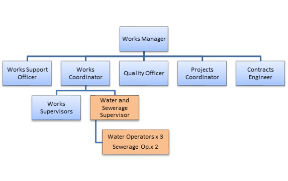
The current structure has led to a number of issues which impact on communication and coordination within the section and reporting lines have been blurred by the structure. Staff often work under a coordinator who does not specialise in water and sewer operations which has resulted in water and sewer staff liaising directly with the Manager of Water and Sewer Business. It is not the role of this Manager to be involved in day to day operational issues as the position should be devoted to strategic planning with a major projects focus. The current situation impacts on the ability to provide the appropriate attention to delivering major infrastructure projects.
As a result of the meetings and workshops and consultation with affected water and sewer staff the proposed structure has been developed as follows:
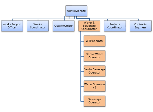
The proposal is to create an additional position of Water and Sewer Coordinator as well as create the position of Water Treatment Plant Operator. It is expected that this change to the structure will provide benefits in the following ways:
(i) Take the burden of day to day operational issues away from the Water & Sewer business Manager so he can focus on strategic planning activities and major projects rather than day to day maintenance activities ;
(ii) The addition of the Murrumbateman Sewerage system will require additional resources as will a future water supply to Murrumbateman. The creation of this additional position provides both a dedicated coordination role and additional capacity to manage current and future operations.
(iii) In recent times, the addition of a treatment process to remove manganese from the water supply and the resulting need to more closely monitor raw water parameters at the water treatment plant have resulted in the requirement for more staffing resources. It is envisaged that the position of WTP Operator will attend to these duties as well as managing testing across the system and preventative maintenance of pumps, pump stations, valves, reservoirs etc.
(iv) The coordinator will assist in the development and implementation of a Drinking Water Quality Management Plan to meet legislative requirements. This will require additional processes, monitoring, testing, and reporting;
(v) The proposed structure provides a career pathway for staff with a number of defined levels within the structure to allow progression as skills and experience are obtained. This is expected to assist with retaining staff in the longer term.
(vi) The creation of a coordinator position will enable knowledge transfer from the Water and Sewer Business Manager to ensure the continued operation of Council’s water and sewer supply systems in the event the manager should leave Council. This is considered a critical succession planning requirement.
(vii) There is an ever growing need for sufficient staff to manage after hours and weekend operation of plants where daily maintenance activities are required to be undertaken. This includes the ability to respond to afterhours callouts for water leaks and sewer chokes.
Limited current staff numbers make on-call rosters problematic especially when individuals are on RDO, annual leave, long service leave, sick leave etc. the creation of the additional role will assist in easing these pressures.
It is estimated that the cost of this additional position to Council would be $70 - $80k per annum. This can be funded from the water and sewer funds. As part of the recent development of Council’s Strategic Business Plan for Water and Sewerage services, the need for an additional staff member in this area was recognised and included in the funding scenarios. Council recently adopted this plan which includes provision for funding this position.
Ordinary Council Meeting 17 December 2014
FILE: W.01.00.00 – SC
The revised policy covers numerous amendments to reflect current processes and to reduce duplication with other Council documents and standards. As part of this review it is suggested that Council offer pressure Reducing Valves (PRV’s) to property owners, at no cost, in identified high pressure areas where static water pressure is likely to be over 500kPa. It would be the property owners responsibility to have the device installed at their own cost.
Pressure reduction valves can be funded from existing operational budgets.
It is intended to write to all property owners who are likely to have water pressures over 500kPa.
|
Social |
Nil |
|
Economic |
Nil |
|
Environment |
Nil |
|
Governance |
Nil |
RECOMMENDATION1. That draft Council policy WS-POL-1 – Water Supply be placed on public exhibition for 28 days. 2. That the draft policy be adopted if no significant objections are received.
|
Attachments: a. Draft policy WS-POL-1 - Water Supply ⇩
Council’s water supply policy has been amended to reflect current practices and to reduce duplication with other Council documents and standards. As part of this review it is suggested that Council offer pressure Reducing Valves (PRV’s) to property owners in identified high pressure areas where static water pressure is likely to be over 500kPa. It would be the property owner’s responsibility to have the device installed at their own cost.
This change is suggested as a result of the variation between the Water Supply Code of Australia which allows for a maximum supply pressure of 800kPa at the supply point (water meter), and the Australian Standard for residential plumbing which specifies a maximum pressure of 500kPa.
Whilst it is the property owners (and their plumbers) responsibility to ensure internal water pressures are restricted to below 500kPa, it is suggested that Council could assist this process by making Pressure reducing valves available. The cost of these valves is approximately $60 for a 20mm sized valve. The supply of PRV’s would be limited to services up to 25mm in size.
The draft policy is included as Attachment A for Council’s consideration.
9.5 Water Supply Policy
Attachment a Draft policy WS-POL-1 - Water Supply
|
Title: |
WATER SUPPLY WS-POL-1 |
Service: WATER
Responsible Officer: WATER & SEWERAGE BUSINESS MANAGER
Objective
To provide a secure water supply to meet current and future needs of the community;
Policy
1. Supply Principles
1.1. Water Security
Council will strive to provide a secure water supply that meets the NSW Office of Water’s 5/10/10 rule as follows:
· The duration of water restrictions does not exceed 5% of the time
· The frequescy of water restrictions does not exceed 10% of years on average
The severity of restrictions on average requires a reduction in water consumption of not more than 10% of normal demand. ·
1.2. Quality
Council will develop and implement a Drinking Water Quality Management Plan to ensure thequality of supply continues to meet the requirements of the Australian Drinking Water Guidelines.
1.3. Pressure
A minimum pressure of 12 metres (=120 KPa) residual head at a flow rate of 0.2 litres per second will be provided at Council’s supply point (water meter location).
A maximum pressure of 80 metres residual head (800kPa) will be provided throughout the water reticulation network. Where water pressures are identified as being above 500kPa, Council will make available on application, a pressure reducing valve to each property free of charge.
1.4. Supply Area
The supply area shall be limited to urban areas or existing areas of supply, in accordance with the attached maps of Yass, Bowning, Binalong & Murrumbateman.
2. Connections
2.1. Multiple Connections
An availability charge shall be applied to each connection to the water reticulation.
If multiple assessments are serviced by a single service, standard availability charge (20 to 32mm water service charge) shall be applied to each assessment.
2.2. New Connections
New connections to existing watermains will be undertaken on application. The applicant is responsible for payment of the water connection fee in accordance withCouncil’s adopted “Fees and Charges”;
Where a watermain extension is required to enable a new connection within the supply area, the applicant will be required to pay the water availability charge plus 50% of the costs of the main extension where the the extension is required in advance of Council’s construction programme. Works will be programmed for construction within six (6) months of receipt of payment.
3. Yass Dam
The use of Motorised Boats on yass Dam is prohibited, with the exception of electric powered boats and those boats on official Government business for such tasks for the Catchment Management, aquatic management and infrastructure management.
Private Jetties and/or other structures in private ownership will not be permitted to be constructed within the Yass Dam storage.
Other Relevant Policies/Procedures
WS-POL-11 Water Supply Restrictions
WS-PR-1 Water Supply Connections
History
|
Minute No |
Date of Issue |
Action |
Author |
Checked By |
|
67 |
12th March, 2003 |
Amended |
David Rowe |
David Rowe |
|
103 |
23 April 2003 |
Amended |
David Rowe |
David Rowe |
|
220 |
28 June 2003 |
Amended |
Siva Sivakumar |
David Rowe |
|
|
22nd June 2005 |
Amended |
Siva Sivakumar |
David Rowe |
|
|
10 July 2008 |
Amended |
Siva Sivakumar |
EMT |
|
330 |
23 July 2008 |
Adopted |
|
Council Meeting |
|
64 |
22 February 2012 |
Amended |
Siva Sivakumar |
Council Meeting |
Ordinary Council Meeting 17 December 2014
9.6 Yass Dam Riparian Revegetation Contract YVC/ASS/07.2014
FILE: T.01.03.00 – SC
SYNOPSIS
Submitting details of tenders received for contract YVC/ASS/07.2014 for the Yass Dam Raising Riparian Revegetation.
OPERATIONAL PLAN AND BUDGET IMPLICATIONS
Long term Goal 1.3 of Council’s operational plan is to Restore and Preserve healthy riparian zones. Council has identified this work as a way of achieving this by planting around the Yass Dam storage area.
Council has allocated funds to this activity for the 2014/15 financial year.
COMMUNICATION PLAN
Negotiation and consultation has taken place with property owners along the dam.
SUSTAINABILITY IMPLICATIONS
|
Social |
Nil |
|
Economic |
Nil |
|
Environment |
The proposed riparian revegetation will have a positive impact on the biodiversity of the river foreshores and assist with improving water quality in the river. |
|
Governance |
Nil |
|
That this Item of the Director of Engineering Report be classified as CONFIDENTIAL and considered in the Closed Meeting of Council in accordance with Section 10A(2)(d)(i) of the Local Government Act as the material in this report is commercial information of a confidential nature. |
Attachments: Nil
REPORT
As part of the Yass Dam Raising project, Yass Valley Council is required to offset inundated vegetation through the revegetation of riparian land along the new Full Storage Level (FSL).
The revegetation works are to be undertaken on private property under agreements between Council and the individual landowners. These agreements (Property Vegetation Plans) are currently being negotiated by South East Local Land Services(LLS) and will clearly define the extent of revegetation works that are to be undertaken on the individual properties.
The initial aims of the PVP’s are to gain an agreement with each landowner to undertake:
· Weed control;
· Primary revegetation of the riparian zone (to extend at least 20m above the new top water level); and
· Fencing of revegetated areas to exclude stock.
Council has set a target of revegetating 17.7 hectares of riparian land.
Tenders were advertised in the Sydney Morning Herald and on Council’s Tenderlink E-Tendering portal and submissions were received until 4:00pm Monday 24th October 2014. Tenders were received from the following contractors:
· Earth Repair and Restoration Pty Ltd
· Natural Capital Pty Ltd
Details of the tender evaluation process and tendered prices have been provided in the attached confidential report.
Ordinary Council Meeting 17 December 2014
10.1 Fees and Charges Waived Under Delegation
FILE: CD.01.00.00 – CC
To advise Council of fees and charges waived by the General Manager, in consultation with the Mayor, under delegated authority for the period September 2013 to November 2014.
All fees and charges waived are funded from the annual donations budget.
n/a
|
Social |
Donations provide significant relief to a number of community organisations. |
|
Economic |
There is an impact on Council’s total income stream however this would be considered to be offset by the benefits to the organisations. |
|
Environment |
N/A |
|
Governance |
N/A |
RECOMMENDATIONThat the information be noted. |
Attachments: Nil
In accordance with the delegation provided by Council March 2013, the General Manager, in consultation with the Mayor, is authorised to waive hiring fees and charges where satisfied it is warranted by the circumstances. The following donations were approved under this delegation.
|
ORGANISATION |
PURPOSE/EXPLANATION |
AMOUNT |
DATE APPROVED |
DATE REFUSED |
|
Yass Bowling Club |
Reimbursement of DA fees for construction of shed |
$806.90 |
|
26/8/13 |
|
Yass Rostrum |
Reimbursement of hire fees for Yass Soldiers Memorial Hall for ‘Meet the Candidates’ evening |
$185.00 |
15/11/13 |
|
|
STARTS |
Reimbursement of hire fees for Yass Soldiers Memorial Hall for Melbourne Comedy Festival |
$185.00 |
5/4/14 |
|
|
The Vine Church |
Reimbursement of hire fees for Yass Soldiers Memorial Hall for 2013 annual Christmas party |
$185.00 |
12/6/14 |
|
|
Yass Valley Men’s Shed & University of the 3rd Age |
Reimbursement of Section 68 fees associated with Car Boot Sale |
$190.00 |
12/6/14 |
|
|
National Trust |
Provision of additional funds to assist support various community events at Cooma Cottage |
$4,313.60 |
|
11/6/14 |
|
Maddison Senior |
Reimbursement of hire fees for Yass Soldiers Memorial Hall for a private event |
$145.00 |
|
12/6/14 |
|
Yass Clay Target Club |
Donation to cover rate expenses incurred for 13/14 financial year |
$414.95 |
|
29/8/14 |
|
Gundaroo Music Festival |
Reimbursement of Council fees for Gundaroo Music Festival |
$535.00 |
|
29/8/14 |
Ordinary Council Meeting 17 December 2014
FILE: F.01.04.04 – SD
SYNOPSIS
Submitting Investment Report as at 30 November 2014.
OPERATIONAL PLAN AND BUDGET IMPLICATIONS
Council’s investment portfolio provides funding for some projects identified in the Operational Plan.
COMMUNICATION PLAN
N/A.
SUSTAINABILITY IMPLICATIONS
|
Social |
N/A |
|
Economic |
N/A |
|
Environment |
N/A |
|
Governance |
Ensure compliance with the Local Government Act, Regulation and Council’s Investment Policy. Funds invested with due diligence and with consideration of Council’s liquidity requirements. |
|
The Investment Report as at 30 November 2014 be received and it be noted that the summary has been prepared in accordance with the Act. The Regulation and Council’s Investment Policy.
|
Attachments: Nil
REPORT
1. Introduction
In accordance with the Local Government (General) Regulation 2005 (NSW) Section 212, this report provides a summary of Council’s investments as at 30 November 2014. In accordance with Section (1)(b), it can be certified that the investments listed have been made in accordance with the Act, the appropriate Regulation and Council’s Investment Policy.
2. Comments on Investments
The RBA has again left the cash rate unchanged at 2.5% during its December meeting. Term deposit rates appear to be less attractive in the current economic climate and this would normally be apparent when there is an expectation of interest rate cuts, but in the current market this seems unlikely. Council’s term deposits are currently achieving interest rates of approximately 1% above the cash rate. Valuations of Council investments as at 30 November 2014 are detailed below. As in previous years, complete valuations for the month of December 2014 together with January 2015 will be provided to the February meeting of Council.
3. Calculation of Interest
A number of Council’s investments have complex factors involved in the calculation of interest (excluding term deposits and cash accounts). The information shown below forms only part of the interest calculation and should be taken as an indication of the relevant interest rate only. Further information, including any contingencies, is held in Financial Management and can be made available on request.
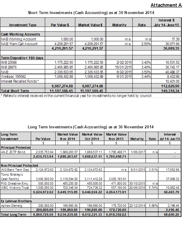
Ordinary Council Meeting 17 December 2014
10.3 Model Code of Conduct Complaint Statistics 2013/14
FILE: P.02.02.00 – SN
SYNOPSIS
Council is required to report, by 30 November each year, to the Office of Local Government on statistics relating to Code of Conduct complaints against Councillors and the General Manager for the period 1 September to 31 August. For the year to 31 August 2014 eight such complaints were received, seven against Councillors and one against the General Manager.
OPERATIONAL PLAN AND BUDGET IMPLICATIONS
The cost of Code of Conduct complaints against Councillors and the General Manager during the reporting period, including staff time, was $15,924. All costs have been absorbed in the current year’s budget but may affect other projects as we get closer to the end of the financial year.
COMMUNICATION PLAN
N/A
SUSTAINABILITY IMPLICATIONS
|
Social |
N/A |
|
Economic |
N/A |
|
Environment |
N/A |
|
Governance |
The Model Code of Conduct sets the minimum requirements of conduct for council officials in carrying out their functions. The Model Code, which has been adopted by Council, is prescribed by regulation. |
|
That the information be noted.
|
Attachments: Nil
REPORT
In the reporting period 1 September 2013 to 31 August 2014, the following Code of Conduct complaints were received.
|
|
Against Councillors |
Against the General Manager |
Completed at 31/8/14 |
Completed at 10/12/14 |
|
|
No of Code of Conduct Complaints received |
7 |
1 |
5 |
1 |
|
|
Dismissed on procedural grounds |
0 |
1 |
|
|
|
|
Resolved by alternate means by the General Manager or Mayor |
3 |
|
3 |
|
|
|
Referred to an External Conduct Reviewer |
4 |
|
|
|
|
|
|
- Dismissed at Preliminary Assessment stage with no action |
1 |
|
|
|
|
|
- Assessed at Preliminary Assessment stage as requiring investigation |
3 |
0 |
1 |
|
There are currently 2 Code of Conducts complaints outstanding which were considered together by the External Conduct Reviewer. The final report in relation to these complaints will be considered by Council in closed session at the February 2015 Council meeting.
Ordinary Council Meeting 17 December 2014
11.1 Local Government Reform - Fit for the Future
FILE: G.02.05.00 – DR
SYNOPSIS
Updating progress on Council Fit for the Future program and foreshadowing the need for Council to consider a special rate variation in 2015/16 as the first stage of ensuring ongoing sustainability of Yass Valley Council.
OPERATIONAL PLAN AND BUDGET IMPLICATIONS
Strategic Action 7.1.2.2 “Assess the need for a special rate variation and pursue as appropriate” is reflected by the recommendation to lodge an application for 2014/15.
Engagement of technical experts to assist with the preparation of Fit to the Future and/or Special Rate Variation Application is expected to cost in the order of $30,000 to $80,000. At this stage it would add to the budget deficit however we would be scanning the budget for savings to offset these expenses if at all possible.
COMMUNICATION PLAN
Both the Fit For The Future (FFTF) and Special Rate Variation (SPV) work will require individual community engagement plans. These will be brought to Council in detail at the meeting proposed on 4 February 2015.
SUSTAINABILITY IMPLICATIONS
|
Social |
Any rate increase will impact on the disposal income of ratepayers. An analysis of the impact of various rate categories including pensioners will be prepared as part of this analysis. |
|
Economic |
Council’s economic sustainability will be dependent on appropriate special rate variations being considered by Council. |
|
Environment |
N/A |
|
Governance |
Notification to IPART for an SRV was required by the 12 December 2014. The full application for an SRV must be submitted to IPART by 16 February 2015. The proposal for the FFTF must be submitted to the Office of Local Government by 30 June 2015. |
|
1. That Council lodges a special rate variation application with IPART for 2015/16; 2. That technical advisors be engaged as required to assist with the preparation of Councils “Fit for the Future’ proposal and/or Special Rate Variation application for 2015/16.
|
Attachments: Nil
REPORT
1. Commencement of Program for FFTF
The NSW Independent Local Government Review Panel in its “Revitalising Local Government “ report released in October 2013 outlined a number of merger options for neighbouring Councils however there was ‘no change’ recommended for Yass Valley Council.
The NSW Government outlined its proposed reform agenda tilted ‘Fit for the Future’ in October 2014 and a brief report was presented to the October meeting where Council resolved that:
“a submission be prepared and lodged to the Office of Local Government on the basis of Yass Valley Council being a standalone Council into the future”.
Table 1 below summarises the proposed timetable for completion of our FFTF ‘Improvement Proposal’ submission and includes a workshop with Council on the 4 February 2015.
Table 1 – Project Plan for Fit for the Future Submission
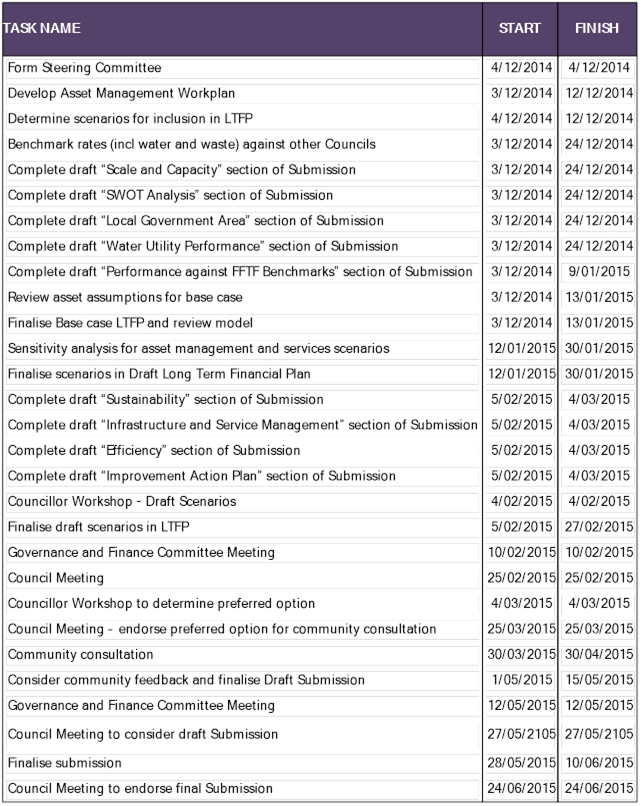
As outlined by the Office of Local Governments FFTF package the proposal must cover key issues such as:
· Scale and Capacity: although though there are no specific benchmarks established The Panel indicated that Councils needed to be sufficiently large to possess:
o A robust revenue base with an increased discretionary spend
o Scope to undertake major projects and employ a wide range of skilled staff
o Advanced skills in strategic planning
o High quality political and managerial leadership
o Effectiveness as regional partner
· Identifying Councils current position:
o Key challenges and opportunities
o FFTF – Sustainability Benchmarks (Financial / Asset Management)
o Water Utility Performance
· Becoming Fit for the Future:
o Identify strategies to ensure future sustainability
o Develop Improvement Action Plan
The Office of Local Government recently has established technical advisory panels under the four categories of Financial Sustainability, Asset and Infrastructure Management and Planning, Service Delivery and Review and Community Engagement. The majority of the preparation will be undertaken by Council staff however expertise will be drawn from this panel as required to ensure that all requirements of the FFTF are addressed prior to the closing date for submissions of the 30 June 2015.
2. Special Rate Variation
Council adopted a $560,000 budget deficit in 2014/15 which was compounded by a reduction in real funding of $130,000 from the Federal Government not providing any increase in the Federal Assistance Grants. A special rate variation for 2015/16 was foreshadowed following adoption of the budget and if it is not to be considered for 2015/16 then Council will have to again dip into its dwindling cash reserves.
Failure to immediately take action to address asset maintenance issues will have a detrimental long term impact.
As a minimum a special rate variation should consider funding for:
· Bitumen Resealing $250,000
· Gravel Resheeting $50,000
· Timber Bridge Replacement program $200,000
· Restoration of one year of the FAG increase $130,000
A timber bridge replacement strategy is currently under development. The $200,000 allowance above is for an anticipated loan repayment. The total increase of $630,000 is essential to maintain the current level of service and represents an 8.5% rate rise. Combined with the rate peg of 2.4%, the total increase would be 10.9%.
Special Rate variations have been approved by IPART for over 50 NSW Councils over the past 2 years. In contrast to other Council’s in our region, some of which have had multiple applications approved, Yass Valley Council has never applied for a special rate variation. The Local Government Reform Panel held the view that Councils that did not seek special rate variations to maintain their assets could almost be considered to be negligent in their duty.
The FFTF process will identify different levels of service and corresponding rating levels to be considered by Council and the community beyond 2015/16 however it is considered imperative to consider an increase for the next financial year so that asset maintenance is not detrimentally impacted.
Council was required to notify IPART by 12 December 2014 that it intends to apply for a special rate variation for 2014/15.
An application has been lodged with IPART for an 8.5% increase plus the rate peg of 2.4% with the full application to be submitted to IPART by 16 February 2015.
The process will require a community consultation phase without which it is unlikely that any increase would be approved by IPART. Council has the ability to withdraw the application or not impose the rate increase even it was approved by IPART.
Ordinary Council Meeting 17 December 2014
11.2 Yass Business and Cultural Precinct
FILE: G.02.05.00 – DR
SYNOPSIS
Redevelopment of the precinct has been on Council’s agenda for many years however the absence of a major funding source has seen a lack of progress. Broad concept plans have been developed and should now be used to develop a business case to attract future tenants and prospective business partners.
OPERATIONAL PLAN AND BUDGET IMPLICATIONS
The Delivery Plan identifies Strategic Action 3.1.3.1 to design, investigate funding options and undertake project planning for a new civic centre in Yass.
COMMUNICATION PLAN
Community consultation was originally undertaken in 2006. This identified a need for a mix of community uses on the site in addition to the Council administration building however a renewed community engagement will be undertaken if there is a positive business case for the development to proceed in the immediate future.
SUSTAINABILITY IMPLICATIONS
|
Social |
Any rate increase will impact on the disposal income of ratepayers. An analysis of the impact of various rate categories including pensioners will be prepared as part of this analysis. |
|
Economic |
Council’s economic sustainability will be dependent on appropriate special rate variations being considered by Council. |
|
Environment |
N/A |
|
Governance |
N/A |
|
1. Seek quotations to undertake a Business Case analysis for the development of business/ cultural precinct on the 209 Comur Street site; 2. The General Manager in consultation with the Mayor and Deputy Mayor be authorised to engage a consultant to undertake the Business Case Analysis; 3. A further report be brought back to Council on receipt of the Business Case Analysis to consider seeking a private-public partnership for the development of the site.
|
Attachments: Nil
REPORT
1. Background
Council has discussed the prospects of commercially developing the site of the current Council chambers and the surrounding land on a number of occasions. The lack of ready funding has been the major reason that the project has not progressed.
A draft concept plan was prepared by Cox Architects in April 2012 and Council resolved on the 27 March 2013 that:
1. Council proceed to investigate 209 Comur Street Yass site as the location for a future retail, commercial office community space and parking;
2. Geotechnical investigations be undertaken on the site as soon as practicable;
3. Cox Architects be engaged to prepare detailed concept plans for a multi-purpose commercial building on the south east corner of the site.
Preliminary geotechnical investigations indicate that whilst there will be some minor site remediation to be undertaken in the vicinity of the existing fuel tanks on the old petrol station site there was no major contamination of the site that would be an impediment to development.
In April 2014 Council reconsidered the draft concept plan and expressed the view that a more general concept should be compiled that could provide development along Adele Street as well as Comur Street frontages. A broad concept for the site was drawn by Cox Architects in May 2014 (refer sketch below).
The Main Street Strategy developed earlier this year and adopted by Council in July 2014 clearly identified that as part of the journey to revitalise the main street that 209 Comur Street needs to be redeveloped.
It is now considered to be time to examine all avenues to determine whether it is feasible to proceed with the project at this point in time or whether it has to wait several more years until there is an identified income stream to develop the site.
2. Project Development
The project is proposed to have a business and cultural focus with the development of a new Council administration building. The current administration building has gone well beyond its useful life in terms of functionality and serviceability by today’s standards. The long held view is that any redevelopment of the administration building must be funded by sources other than rates. That is, the building must be funded from profit generated from another development such as the Woolworths Development, by grant funding or by a joint venture with a developer. However, should these funding sources not eventuate there will come a time when council has no other choice but to consider a loan in order to strategically plan for the future as the Local Government Area expands and provide staff accommodation and a council chamber that residents ought to be rightly proud of.
Regardless as to how the project is brought together, it is necessary that it is financially sustainable. As a starting point any new buildings need some anchor tenants as a catalyst for the development to proceed. There must be a business case to support the development.
Prospective tenants could be:
· Smart work hub users
· Art and cultural activities
· Library
· Community services
· Federal and State Government Agencies
· Council
· Commercial offices
· Retail along Comur Street frontage
Efforts have recently been concentrated on trying to acquire interest from Federal and or State agencies. There is a mood for decentralisation in both government jurisdictions and it is therefore considered important to be able to demonstrate a sound business case to prospective clients in a bid to convince them to relocate their operations to Yass.
3. Next Steps
1. Continue to canvass politicians in a bid for the relocation of some government services to Yass.
2. Undertake a business case analysis to demonstrate the financial viability of the project and outline rental costs to prospective tenants.
3. Seek a partner to assist Council to develop the site. Following preparation of the business case analysis a report be presented to Council to consider calling an expression of interest seeking to develop a public private partnership for the development of the site.
![]()
![]()
![]()
![]()

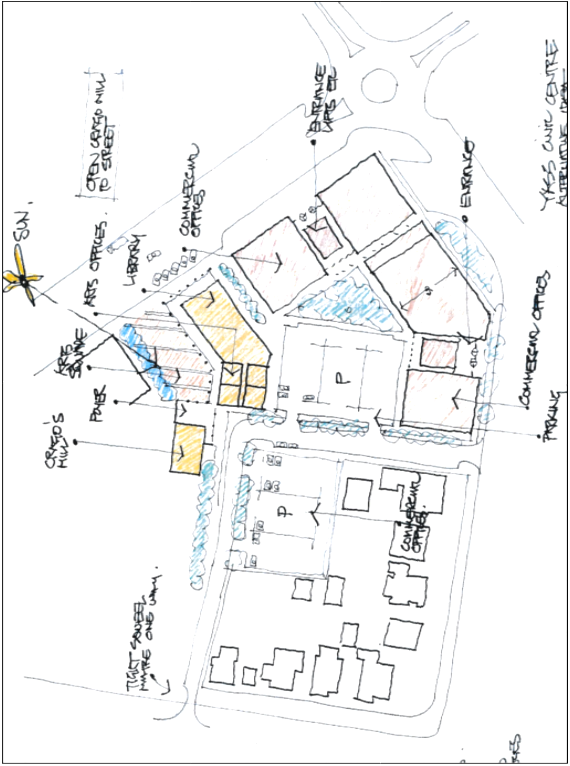
Ordinary Council Meeting 17 December 2014
12.1 Strategy to Reduce Council Operating Costs
FILE: C.07.00.02 – G
Councillor Geoff Frost has given notice that at the Ordinary Council Meeting on 17 December 2014, he will move the following motion.
Councillor: Geoff Frost, Councillor