![]() Ordinary Meeting of Council
Ordinary Meeting of Council
Wednesday 28 April 2021
4.00pm
Council Chambers
209 Comur Street, Yass
![]() Ordinary Meeting of Council
Ordinary Meeting of Council
Wednesday 28 April 2021
4.00pm
Council Chambers
209 Comur Street, Yass
|
PRAYER:
All Stand:
Mayor: Let us be still and remember the presence of God. As we commence our meeting let us together pray for guidance and help.
All say together:
Almighty God, we ask your blessing upon this Council.
Direct and prosper our deliberations to the true welfare of Australia and the people of Yass Valley Amen.
|
FUTURE MEETINGS
|
May 2021
Wednesday 26th 4.00pm Ordinary Meeting of Council
|
Ordinary Meeting of Council
Open Forum Page No.
Webcasting
This meeting is being webcast, a reminder to those in attendance that you should refrain from making any defamatory statements.
Acknowledgement of Country
I acknowledge that we are meeting on the ancestral land of the Ngunnawal people. I recognise the Ngunnawal as the traditional custodians and pay respect to the Elders of the community and their descendants.
1. Prayer
2. Apologies
3. Declaration of Pecuniary Interests/Special Disclosures
4. Confirmation of Minutes
Minutes of Ordinary Council Meeting held on 24 March 2021................................................. 5
6. Director of Planning & Environment Reports
6.1 Community Grants 2020/21 Round 2................................................................................... 15
7. Director of Infrastructure & Assets Reports
7.1 Shared Path, Dutton Street Yass - Request for Review.......................................................... 20
7.2 Flood Mapping Addendum for the Flood Studies Prepared for the villages of Murrumbateman, Bowning, Bookham, Binalong, Gundaroo and Sutton............................................................ 36
7.3 Yass Flood Risk Manangement Plan & Study....................................................................... 110
8. Director of Corporate & Community Reports
8.1 Rates Arrears.................................................................................................................... 114
8.2 Investment and Borrowings Report - March 2021............................................................... 116
8.3 2021/22 Draft Operational Plan......................................................................................... 120
9.1 Yass to Murrumbateman Water Supply Pipeline - Easement Acquisition.............................. 127
9.2 Quotation Evaluation Report - Supply and Delivery of Motor Grader................................... 128
Nil
11.1 Questions With Notice - Cr Geoff Frost............................................................................... 130
12. Minutes and Recommendations of Council Committees
12.1 Minutes of the Canberra Region Joint Organisation Board Meeting held on 26 March 2021.. 137
12.2 Minutes of the Audit, Risk & Improvement Committee Meeting held on 30 March 2021...... 154
13. Confidential Matters.................................................................................................... 163
The following matters are classified as CONFIDENTIAL and will be considered in the Closed Meeting of Council in accordance with Section 10A(2) as they deal with commercial, personnel and legal matters:
13.1 Yass to Murrumbateman Water Supply Pipeline - Easement Acquisition.............................. 163
13.2 Quotation Evaluation Report - Supply and Delivery of Motor Grader................................... 163
Close of Meeting Time
Chris Berry
GENERAL MANAGER
Minutes of the
Ordinary Meeting of Council
Wednesday 24 March 2021
4.00pm
Council Chambers
209 Comur Street, Yass
Table of Contents
1. Prayer
2. Apologies
3. Declaration of Interest/Disclosures
4. Confirmation of Minutes
5. Mayoral Minute
5.1 Walker Park Grandstand
6. Director of Planning & Environment Reports
6.1 Development Application No DA200109 - Erosion Gully Rehabilitation, 66 Brooklands Road, Wallaroo
6.2 Graffiti Art Trial
7. Director of Infrastructure & Assets Reports
7.1 Yass Water Treatment Plant Upgrade Project: Design and Business Case Preparation
7.2 Water Extraction from Council Standpipe
7.3 Safety Concerns Burley Griffin Way Binalong - Safety Barrier Update
8. Director of Corporate & Community Reports
8.1 Investment and Borrowings Report - February 2021
8.2 Non-Rate Income
9. General Manager Reports
9.1 Yass Soldiers Memorial Hall - Reimbursement of Costs
9.2 Tender Evaluation Report - Murrumbateman Winery Trail YVC.IA.18.2020
10. Notice of Motion
11. Questions with Notice
12. Minutes and Recommendations of Council Committees
12.1 Minutes of the Economic Development Committee held on 3 December 2020
12.2 Minutes of the Country Mayors Association held on 5 March 2021. 8
13. Confidential Matters
13.2 Tender Evaluation Report - Murrumbateman Winery Trail YVC.IA.18.2020
Mr Salahuddin Qureshi
Mr Mohammad Rahman
Mrs Afsana Hayat
Ms Rufayda Tazmeen
Mr Thomas Stoneham
Mr Sanjaya Vithanage
Open Forum
Presentations to Council – Items on the Meeting Agenda
· Item 6.1 Development Application No DA200109 – Erosion Gully Rehabilitation, 66 Brooklands Road, Wallaroo
Paul
Newell
Jodie Newall
Council Meeting - The Mayor declared the meeting open at 4.57 pm.
Present
Councillors Rowena Abbey, Mayor, in the chair, Cecil Burgess, Geoff Frost, Nathan Furry, Allison Harker, Jasmin Jones, Michael McManus, Mike Reid and Kim Turner.
Also present were the General Manager – Chris Berry, Director of Planning & Environment – Julie Rogers, Director of Infrastructure & Assets – James Dugdell, Director of Corporate & Community – Mark Eady and Corporate Planning & Executive Support Officer – Shirree Garland.
Acknowledgement of Country
1. Prayer
2. Apologies
Nil
3. Declaration of Interest/Disclosures
Councillor Abbey declared a significant, non-pecuniary conflict of interest in Items 9.1 and 13.1 – Soldiers Memorial Hall - Reimbursement and stated that she believed her interest would preclude her from voting.
Reason: Councillor Abbey declared an interest as she is a friend of the proponent.
4. Confirmation of Minutes
|
RESOLVED that the minutes of the Ordinary Council Meeting held on 24 February 2021 resolution numbers 1-41 inclusive, be taken as read and confirmed. (Furry/Reid) 42 |
FOR: Councillors R Abbey, C Burgess, G Frost, N Furry, A Harker, J Jones, M McManus, M Reid and K Turner
AGAINST: Nil
5. Mayoral Minute
FOR: Councillors R Abbey, C Burgess, G Frost, N Furry, A Harker, J Jones, M McManus, M Reid and K Turner
AGAINST: Nil
6. Director of Planning & Environment Reports
|
|
|
SUMMARY This report advises on the trial of the utilisation of the face of the bridge support under the Hume Bridge as a ‘free wall’ for graffiti art over recent months, as resolved by Council at its October 2020 meeting.
|
|
1. Utilisation of the wall under the Hume Bridge as a ‘free wall’ for graffiti art be permitted to continue. 2. A sign be installed at the site stating that the area is a ‘free wall’ for graffiti art. 3. A garbage bin be placed at the site. (Furry/Harker) 46 |
FOR: Councillors R Abbey, C Burgess, G Frost, N Furry, A Harker, J Jones, M McManus, M Reid and K Turner
AGAINST: Nil
7. Director of Infrastructure & Assets Reports
FOR: Councillors R Abbey, C Burgess, G Frost, N Furry, A Harker, J Jones, M McManus, M Reid and K Turner
AGAINST: Nil
FOR: Councillors R Abbey, C Burgess, G Frost, N Furry, A Harker, J Jones, M McManus, M Reid and K Turner
AGAINST: Nil
FOR: Councillors R Abbey, C Burgess, G Frost, N Furry, A Harker, J Jones, M Reid and K Turner
AGAINST: Councillor M McManus
8. Director of Corporate & Community Reports
FOR: Councillors R Abbey, C Burgess, G Frost, N Furry, A Harker, J Jones, M McManus, M Reid and K Turner
AGAINST: Nil
|
|
|
SUMMARY To present a report on various revenue sources. |
|
1. The report on non-rate/grant income, revenues from lease of road reserves, income from caravan park, business leases and tip fees be noted. 2. A revised Long Term Financial Plan (10 year) be provided to the May 2021 Council meeting. (Harker/Turner) 51 |
FOR: Councillors R Abbey, C Burgess, G Frost, N Furry, A Harker, J Jones, M McManus, M Reid and K Turner
AGAINST: Nil
9. General Manager Reports
At 06:18 pm Councillor Abbey left the Chambers.
Councillor Furry, Deputy Mayor, took the Chair.
FOR: Councillors C Burgess, G Frost, N Furry, A Harker, J Jones, M McManus, M Reid and K Turner
AGAINST: Nil
At 06:22 pm Councillor Abbey returned to the Chambers.
FOR: Councillors R Abbey, C Burgess, G Frost, N Furry, A Harker, J Jones, M McManus, M Reid and K Turner
AGAINST: Nil
10. Notice of Motion
Nil
11. Questions with Notice
Nil
12. Minutes and Recommendations of Council Committees
|
12.1 Minutes of the Economic Development Committee held on 3 December 2020
|
|
RESOLVED that the minutes of the Economic Development Committee meeting held on 3 December 2020 be noted. (Harker/Frost) 54 |
FOR: Councillors R Abbey, C Burgess, G Frost, N Furry, A Harker, J Jones, M McManus, M Reid and K Turner
AGAINST: Nil
|
12.2 Minutes of the Country Mayors Association held on 5 March 2021
|
|
RESOLVED that the Minutes of the Country Mayors Association General Meeting held on 5 March 2021 be noted. (Furry/Reid) 55 |
FOR: Councillors R Abbey, C Burgess, G Frost, N Furry, A Harker, J Jones, M McManus, M Reid and K Turner
AGAINST: Nil
13. Confidential Matters
FOR: Councillors R Abbey, C Burgess, G Frost, N Furry, A Harker, J Jones, M McManus, M Reid and K Turner
AGAINST: Nil
Closed Council commenced at 6.24 pm.
|
13.2 Tender Evaluation Report - Murrumbateman Winery Trail YVC.IA.18.2020
|
|
SUMMARY This report provides advice on the submission of tenders for the construction of the Murrumbateman Winery Trail. |
|
RESOLVED that the tender submitted by Complete Civil Pty Ltd to undertake the Murrumbateman Winery Trail (Contract No.YVC/IA/18.2020) be accepted as per the unit rates submitted with the tender offer. (Furry/Reid) 57 |
FOR: Councillors R Abbey, C Burgess, G Frost, N Furry, A Harker, J Jones, M McManus, M Reid and K Turner
AGAINST: Nil
|
RESOLVED that the meeting move into Open Council. (Furry/Turner) 58 |
FOR: Councillors R Abbey, C Burgess, G Frost, N Furry, A Harker, J Jones, M McManus, M Reid and K Turner
AGAINST: Nil
Open Council resumed at 6.28 pm.
|
RESOLVED that the recommendations in Closed Council be adopted. (Reid/Furry) 59 |
FOR: Councillors R Abbey, C Burgess, G Frost, N Furry, A Harker, J Jones, M McManus, M Reid and K Turner
AGAINST: Nil
The
meeting closed at 6.28 pm.
![]()
Rowena Abbey
Mayor
Ordinary Council Meeting 28 April 2021
6.1 Community Grants 2020/21 Round 2
A report recommending grants to be made through Council’s Community Grants Program- Round 2.
Council allocated $49,000 to Community Grants in the 2020/21 budget, with $28,362 allocated in Round 1. $20,638 is available for Round 2. The recommended grant for Round 2 total $17,855.
· Local Government Act 1993
· Community Grants Policy
A total of 10 applications were received and assessed by a panel comprising Cr Turner, Cr Frost and the Strategic Planning Manager. Details of the applications are in Attachment A. The panel members declared no pecuniary and non-pecuniary interests in the applications.
The application from Murrumbateman Village market requires Development Consent, and in accordance with the Community Grants Policy, this was required to be obtained prior to the application being lodged. In this instance the panel agreed to conditionally recommend this project be funded if development consent is obtained.
Three applications are not recommended for funding:
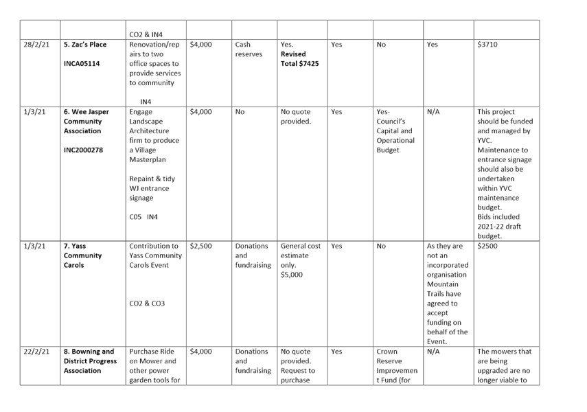
· Wee Jasper Community Association to engage a landscape architecture firm to produce a Village Masterplan and repaint and tidy entrance signs. This project should be funded and managed by Council. Maintenance to entrance signs should also be undertaken within Council’s maintenance budget. The draft 2021/22 budget includes an allocation for a Wee Jasper Masterplan.
· Bowning and District Progress Association to purchase a second hand ride on mower from Council and other power garden tools for maintaining nature strips, recreation ground, cemetery and church grounds. The mowers that are being upgraded by Council are no longer viable to maintain and operate, and there may be a burden on Council to keep the mower operational and safe. Church land is private property, and the Cemetery and Recreation Ground maintenance (and some roadside mowing) is the responsibility of Council. The Director of Infrastructure & Assets has advised that Council mowing schedules are currently being reviewed.
· The Valley Boxing Gym to construct an outdoor concrete area at 35 Meehan Street, Yass. The gym is a private business, not an incorporated community association or group. Development Consent required for this business (boxing classes) has not been obtained.
The other applications meet the eligibility criteria.
Key Pillar 3. Our Community
CSP Strategy CO2 - Encourage and facilitate active and creative participation in community life
Delivery Program Action CO2.5 - Support the growth of a diverse range of community events
Operational Plan Activity CO2.5.1 - Provide access to financial support for development of community events through Council's Community Grants Program
ATTACHMENTS: a. Community Grants Assessment Matrix Round 2 ⇩
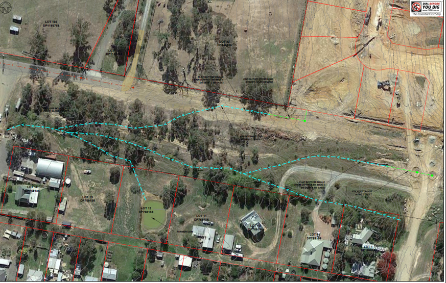
7.1 Shared Path, Dutton Street Yass - Request for Review
Community representations have been received to not construct a footpath proposed for Dutton Street, Yass from Riverbank Park to Rossi Street.
Nil - Should Council decided not to proceed with these works then the grant funding allocated to them will be relocated to another shared path per the Bike Plan and Pedestrian Access Mobility Plan (PAMP) 2017-2027.
· Yass Bike Plan and Pedestrian Access Mobility Plan (PAMP) 2017 - 2027
In 2016/17 Council reviewed it existing Bike Plan and PAMP 2010-2017.
The review included an extensive consultation process including a survey to ascertain the needs and concerns of cyclists and pedestrians in the Yass Valley Local Government Area. The survey distributed widely to residents and community organisations including all schools, retirement facilities, health centres, and public transport providers etc. The survey could be completed on-line or via hard copy.
A draft plan was developed and place on public exhibition in mid-2017 and as subsequently adopted by Council in late 2017.
The adopted plan detailed a range new upgrade works to the value of $1.7M including:
· Kerb ramps
· Footpaths
· Shared Paths
· Pedestrian Refuges
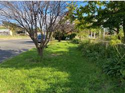
The highest priority shared path identified in the plan was the stage 1 of a shared path to connect existing infrastructure on Riverbank Park to existing infrastructure on Walker Park.
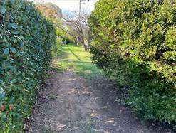
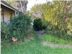
This section of path is an important missing link to connect Riverbank Park, Mount Carmel School, tennis courts, the Rail Museum and ultimately the Civic Precinct along lower traffic volume streets and through parklands. There is evidence of a wear strip from pedestrian movements along the eastern side of the street for the proposed path suggesting it is the preferred travel path.
Stage 1 of these works was the construction of a shared path on Dutton Street from Riverbank Park to Rossi Street (refer the following extract from the Bike Plan and PAMP 2017-2027).
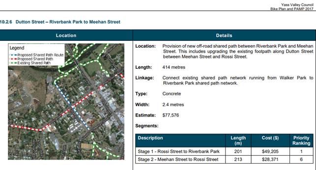
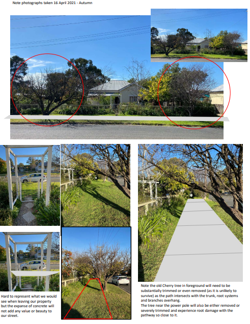
In July 2020 Council considered a report on the Local Road and Community Infrastructure Grant Round 1. This program was created as part of the Federal Government stimulus package associated with the impacts of COVID19. This program was for shovel-ready works that could be delivered before 30 June 2021. The construction of the Dutton Street shared path from Riverbank Park to Rossi Street was one of the projects endorsed for funding under this grant program. The following photographs show the site.
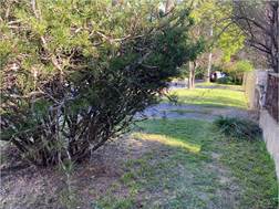
Recently Council staff undertook a site inspection with the contractor selected to deliver this shared path construction. During discussions with residents that were at home at the time it was obvious that these residents are fiercely opposed to the construction of this section of shared path. Subsequently several submissions have been received (refer Attachment A) and staff have met with representatives of all the premises on this section of Dutton Street that will be impacted by the new shared path. It is also noted that representations have been made with the Member for Goulburn, Wendy Tuckerman. The following is a summary the concerns raised:
· Lack of consultation
· Increase temperature caused by the hard surface
· Reduction in the heritage value of this group of residences
· Loss of the charm of the area
· Extra work to maintain the council verge (i.e. more edges to wiper snip)
· Loss of streetscape through the removal or significant trimming of trees
· Loss of a significant and old cherry tree
· Loss of shade
· Increased temperatures in house particularly those built very close to the property boundary
· Increase glare
· Uncertainty about land owners having to formalise their property accesses
· Destruction of garden areas on the council verge
· Reduced on-street parking noting that the older houses do not have on-site parking
· Poor health outcomes from increased noise and glare
· Increased noise close to residents noted the dwelling construction from the time period (some dating back to 1844) did not give much consideration to noise abatement and heat insulation
· Reduce pedestrian/resident safety due to encouraging greater use
· Reduced privacy due to dwellings close to the verge
· Safety concerns relating to residences with driveway not having adequate site distance when reversing out of the property and across the proposed shared path
The footpath design involves narrowing and meandering around exiting street trees to preserve these assets and protect streetscape amenity. The path is a key piece of infrastructure to provide for pedestrian and cycle movements for the wider community. It is recommended that the shared path design and location be endorsed.
Alternate options to the proposed shared path provided by residents include:
· Not undertake these works and use the grant funds in other area e.g. upgrade of the Council land across the road, improve the rail bridge, streetscaping in Comur Street, Yass Memorial pool change room improvements
· Construct the path on the opposite side of the road
· Construct an on-road shared path particularly since this is currently the main way pedestrians are accessing the area and the traffic volumes are very low, this would require the reduction of the speed limit on the road
· Reduce the width of the path from 2.5m to 1.5m
Residents have been advised that their representations will be reviewed and considered by Council. In addition, they were informed of the opportunity to address Council at the Open Forum. In the interim the works have been placed on hold pending the Council decision.
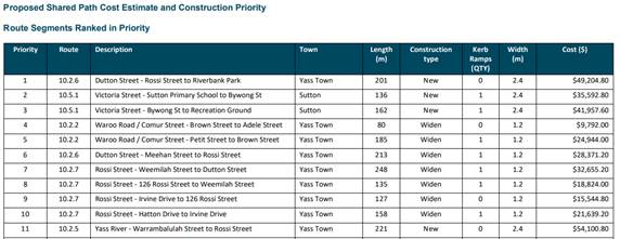
Should Council decide to defer the construction of this particular project the following is a list from the PAMP of five alternate sites. Based on constructability it would be suggested that Priority 6 – Dutton Street-Meehan Street to Rossi Street. Council may also wish to consider other options on the Shared Path priority list below.
Key Pillar 4. Our Infrastructure
CSP Strategy IN3 - Maintain and improve road infrastructure and connectivity
Delivery Program Action IN3.1 - Deliver transport asset infrastructure, maintenance, renewal and enhancement programs for urban, rural and regional roads to maintain or improve overall condition
Operational Plan Activity IN3.1.1 - Develop and deliver annual programs for urban, rural and regional road renewal and construction, including bridges and stormwater
ATTACHMENTS: a. Submissions ⇩
7.1 Shared Path, Dutton Street Yass - Request for Review
Attachment a Submissions
Dear Mayor Abbey and Yass Counsellors,
We have been in contact with Yass Council staff over the last two weeks over the proposed 2.5 metre shared pathway for Dutton Street.
You may have already heard from and spoken to some of my neighbours, and I appreciate your attention and reconsideration of this matter.
I have applied to speak at the next Council meeting with my neighbour Linda Swadling, where we will talk to you about the:
· Loss of heritage appeal and charm of the street with houses from 1844 and through the 1920s
· Temperature rises from additional hard surfaces on our streetscape
· Loss of bird habitat all the way down the street as many established trees and shrubs are damaged and/or removed/killed by the work.
Please see attached the visual representation (I did not have Photoshop to make it realistic!) of what the pathway would do to the look of the front of our house and the damage to our specific trees.
Please also note that while I believe there was general community consultation via a consultant, at no time were we or the other residents of Dutton Street, consulted about this addition to our heritage listed street.
Had that direct consultation happened (with very little time and effort) it would have resulted in the funding going to a street that would be much better suited to a 2.5 metre wide shared pathway in the Yass Valley.
I appreciate everyone is busy however I would appreciate a short acknowledgement from yourselves that this is a concern from a resident.
I look forward to meeting you at the April Council meeting.
Many thanks
I am writing this email to voice my objection for the proposed shared path in Dutton Street.
I have lived In Dutton Street for 28 years and have several issues with the path you are planning to destroy our nature strip with. I also have an issue with how this has been dealt with by the council.
Until this week the residents of our street received zero notice of the proposal. On Tuesday we received a notice that the concreters would be door knocking to discuss disruptions due to their work. There was no information about the path included in the letter, no indication of the extent of the work, and no information about how we could lodge any complaints about this. When several residents of our street arranged to meet with you to discuss our issues we are then told that the work is beginning on Monday so we do not have time to organise our objections, especially when your office has no phone or email today. This is simply not good enough.
We were told we should have read the 2017-2027 bike plan to know that this was happening. This was not simple to do, and it took a lot of searching to even find it. I would not have found it if I didn't know what I was looking for it. The survey done at the start of the plan only had responses from 0.3% of the residents of Yass Valley. I was actually one of those 43 respondents. From memory the survey was actually specifically advertised on Facebook as being used to assess the suitability of using the old "rail corridor" as a shared path to connect north and south Yass. It is not surprising that so few people responded when that is how it was described. That is not what is being proposed in the plan, and of course it's not when Yass Valley Council does not own that land. I do not understand how you consider this consultation with the community, particularly with the residents affected.
This plan meant to be how we were "informed" of the path. I would like to know how anyone looking at the map is expected to have any idea where the path is going. There is a dotted line marking the direction of the path, but if you're looking at it you will see the line covers the entire street. Have you been down Dutton street recently? It is a large street. There a multi lane road, then then the train tracks, then another lane on the other side, with both sides having a nature strip before the houses. The line on the map clearly covers that whole space. How are residents expected to know which side of the street the path is, or if it's going through the middle. This lack of communication is simply not good enough.
There are trees all along the nature strip, and almost all of them have been here longer than I have. To have a 2.4 metre path placed on this area would mean that every single tree on this section of the street would have to be ripped out. How can the council claim to be trying to help the environment by encouraging bike riding, and then in the same plan remove many trees that are 30+ years old. Where do you plan to replant trees to make up for that? And how to plan to make up for the 30+ years lost? It's not possible.
Take a walk down our street on a summer evening and you'll likely come across a family of kangaroos or a wallaby or two eating the grass. Late summer into early autumn you'll find the massive flock of bats living in the trees. Year round the street is home to at least one echidna and dozen of possums use our trees as home and for food. During the 2019/2020 bushfire season it became common for yellow-tailed black cockatoos to be found in the trees. With all these native species calling our street home it would be despicable to remove the green space and replace it concrete. A huge reason for many people choosing to live in this town is for the country environment, including the nature reserves and wild life. If we wanted concrete and asphalt we would live in the city.
We were told that safety issues would not be considered in our objections. I find it DISGUSTING that we were told this. Your jobs on the council should be to serve the residents, and if ensuring our safety is not your number one concern then how can you consider yourselves fit to serve us? I am the mother of two young children, and to be told that our safety concerns do not matter is horrifying. I do not want to bring my children up in a town where safety is not important.
I personally do not drive. I walk my children to school and day care. I walk to work. I walk to the shops and the doctors and anywhere else I need to get to. If anyone in this street understands what it's like to get around without a car in this town then it is me. I would not feel safe using a shared path in Dutton Street. I do not want to walk out my front gate and be knocked down by a cyclist going 20km/hr. I also would not consider it a safe option as a cyclist. I would like to be able to leave my house without being put at risk.
I am well experienced with the paths that currently exist. The current bike path at the park is not fit for purpose. When the current path was laid there was not proper consideration for drainage and as a result the path joining the road to the park gets flooded everytime we get even a small amount of rain. You also would be well aware than the bridge at duck pond weir also floods most years, sometimes dozen of times as does the low level crossing. There are also countless spots where the path has shifted, presumably from tree roots, and are major trip hazards. I am often seeing children falling on bikes because of this. I also personally struggle because I can not push a pram over some of these bumps, which is particularly a problem on the path from the river to Yass Public School. My elderly father has also had his mobility scooter completely tip over, and I know he's not the only one to have experienced this. The fact that this path had been in for over twenty years and I can not once remember any maintenance being done to it is a scary thought. I do not want the path extended in front of my house only for it to become a hazard in 5 years and for you not to maintain it. You've shown that this will be a problem by the way the rest of the paths in this town are maintained, and by telling us that safety is not a concern.
As far as I'm concerned a good bike path is one that gets cyclists moving without stopping. A continuous paths that does not interact with road traffic. This works in the park, but does not work when crossing driveways and intersecting busy roads such a Rossi street. I invite you to sit on the corner of Dutton and Rossi streets between 2:45 and 3:15 on Tuesday when school has returned. You will then surely reconsider if it is a spot you wish to encourage bike riders, especially children, to attempt to cross the road on a bicycle. This is not the area for a shared path.
If you look at the existing bike paths you'll find the bike path at riverbank park is ALREADY connected to the main street. The path goes through Riverbank Park, along the creek and comes out by the bus depot. Directly across the road is the Bus Stop, and a perfectly good Path through Banjo Patterson Park. For those people wishing to catch the Bus to Canberra all that would be needed is a bike rack at the bus stop. For those wanting to access local businesses the main street is just metres away, with an existing bike rack outside the toilets connected to to library. Why would someone ride their bike from Riverbank Park UP a ridiculous hill (have you ever tried riding a bike up the hill from Riverbank Park towards the train bridge?) To ride along Dutton Street then back down the hill of Rossi street, when there is a perfectly flat path linking riverbank Park to Banjo Patterson Park?
There are many more reasons I do not want this path put in, but I do not expect that any of you are actually reading our objections in their entirety. I suspect the fact we were not informed of the path was not an accident, rather that you knew we would take issue with it and did not want to give us a chance to object. As this is the attitude of the council, and the disregard for our safety concerns, I do hope that none of the councillor's expect my vote at the next election, because they will not receive it if this path goes ahead.
There is already a path linking the river loop to the main Street. Dutton street is one of the older streets in town and we should not ruin it for the sake of adding in a path that no one wants.
Thank you,
Dear Terry
We write to you in regards to the planned cycleway construction for Dutton Street, which if constructed will run down the side of our house, as our house fronts Rossi Street.
We have heard the opinions of many of our neighbours along this street, who are all against the proposed cycleway, as are we.
While we are not against the progress and improvement of our town, and am aware that the verge is council property, we urge council to consider whether this particular cycleway plan is appropriate. A 2.5 meter cycleway is not appropriate for this street. We would prefer that no construction take place on Dutton Street and that instead the cycleway be utilised somewhere else. A footpath (closer to the roads than the houses) would be better received should works be absolutely necessary.
SIZE - The verge in question commences at our house wide enough to accommodate 2.5 meters, yes. However the verge’s width decreases along Dutton Street and would barely be 2.5 meters in total once it gets to the end. It is not appropriate surely to suggest a verge on one of the oldest streets in Yass be completely concrete at one end? 2.5 meters may well be the new standard for cycleways, however our houses are not new and this is not proportionate to the house style, age and verge size of the street.
PARKING – Our main concern regarding the construction of the cycleway is parking. While we have always understood that the verge is council property, our house, as with many houses on this end of Dutton Street (in particular our neighbours Linda Swadling and the Phemister’s at the end) do not have adequate parking and should we not be able to park on the verge we would be required to park on the road. Our houses were not built with garages or parking in mind for modern vehicles. While we do have a garage, it is not wide enough to fit in our caravan or car and we would need to park these on the road instead should a cycleway or footpath be installed.
Our house and Linda’s are very close to Mount Carmel School, and due to there not being much available parking for parents/carers along Rossi and Dutton, there are often many people parking along our roads at school pick up and drop off times. We currently require the verge for parking. I am a parent who returns home at that time of the day and worry that I won’t be able to get a park on the road as there are already vehicles parked there, and I may end up struggling to find a park near my house at all. This is also to be said of weekends as our town is now so busy on weekends particularly, that Rossi Street parking is often utilised by Yass Valley residents and visitors as an overflow from the main street parking. If we cannot park on the verge and when the road parking is full then where are we residents to park?
In the creation of the Bike Plan and PAMP 2017 plan was it at all considered that should cycleways or footpaths be installed (particularly in areas where houses like ours lack driveways or sufficient sheds) that there will be an influx of cars requiring to be parked on the streets when street parking is already fully utilised due to our growing town and it’s visitors?
Consider that those walking on this cycleway would be walking between our house and our vehicles which now must be parked on the street, instead of their current walk which is along a quiet street with residents who maintain appealing gardens and lawns which complement our older style buildings.
GREENSPACE - Many of the current verges along Dutton Street provide gardens and plants that give habitats, food and safety for wildlife, assist in cooling older houses, and are currently providing interest to those that do walk down this street. Installing a cycleway would remove the majority if not all of these plants, and would be in conflict with one of the reason why people do enjoy the walk down this street. We are concerned that either footpath or cycleway works will wipe out the majority if not all of these plants and will either not have space to regrow due to their whole verge being concrete, or, those houses that have a wider verge like us will take time and money to re-green. We are interested as to whether this was considered at all in the creation of council’s Bike Plan and PAMP 2017 would see many verge gardens completely removed.
CONSULTATION - We also thought it quite clumsy of council that staffer Kellie Jones and contractor Nick Pollack were discussing works on site, and marking lines with spray paint, prior to residents being advised. This was unnecessary and we believe council should be mindful that sending the letter to homeowners prior to this would be better practice and less stressful for all parties. We would also like to add that newsletters, media releases and documents such as the Bike Plan and PAMP 2017 are not high on our reading lists, and should not be required of us to check in case something that so directly affects us take place.
PLACEMENT - Kellie advised that one reason to install the cycleway is that there is a gap between the existing cycleway that starts at the end of Dutton Street near the Phemister’s and between the footpath on the other end of Dutton Street. However, most people who walk down this end of the street are continuing their natural walking path which is on the other side of the road. I do not believe walkers will cross the road simply to use the path for a few meters. Many walkers and riders who come from the railway end of the street still don’t cross the road to utilise the footpath. Most walkers continue to walk on the other side on the dilapidated road, despite having a footpath on the other side.
We propose that the opposite side of the street be considered. The other side of the road only has one resident, and the rest of that undeveloped and unmaintained and ugly land is council’s land. Instead of paving our nicely kept greenery on this side, was it considered at all that the other side could be just as good?
RIVER WALK - There are many parts of the Yass River walk that could better benefit from the grant. There is much need for the cycleway near the weir to be continued around the RV area near Joe O’Connor Park, which could assist with the current safety issues on that walk. If you currently attempt to cross the weir and turn left to walk under the old bridge, the wire that holds down the rocks is torn up and dangerously sticking up. This has been a safety issue for the 30 years I’ve lived here. If the aim of the Bike Plan and PAMP 2017 “maintain and improve road infrastructure and connectivity” then using the funds in this area would surely be in pursuit of that goal. Linking the RV area to the current weir cycleway towards town would be in line with the Bike Plan and PAMP 2017’s objectives, be better received by community, improve tourist’s connectivity to town businesses and be more in keeping with Yass’s heritage.
We appreciate the work of council and appreciate that council staff work very hard for the benefit of our town.
We kindly urge council to reconsider the proposed works. A cycleway is not appropriate for this street.
Thank you for your email Terry.
A site induction process would indicate that this process (the shared path/cycle way) cannot be negotiated in any way. Use of the word notification reinforces this idea.
The consultation that you refer to did not deal with people who will be directly impacted by
this development. This is not right or fair.
I do not make a habit of keeping up to date with what occurs on the council website. I do not keep up with the local paper as much as I could.
Logic and courtesy would dictate that stakeholders in any development should be liaised with before it came to a point where there is no opportunity to negotiate progress. I am happy to work with council to achieve resolutions that are in the best interests of our community.
I will ring this afternoon to arrange an appointment to speak to yourself – hopefully next week? I am on school holidays at present so this time is what I have to work with during business hours currently.
I look forward to hearing from you again soon.
Yours sincerely,
From:
Terry Cooper <[email protected]>
Sent: Tuesday, April 6, 2021 4:37 pm
Subject: Shared Path Construction - Dutton Street (between Rossi Street
and Riverbank Park)
Good afternoon
Thank you for your email
Firstly I need to correct a misunderstanding, the visit by our staff and the contractor was not meant to be consultation. The site visit was part of the site induction process between Council and the contractor. This meeting would have then be followed by resident notification (eg door knock and/or letter box drop) advising of the work program etc.
Consultation for these works was undertaken several years ago as part of the preparation of the adopted Bike Plan and Pedestrian Mobility Plan (PAMP) 2017-2027.
This plan is available on Council’s website (refer the following tabs Our Council/Council Documents/Individual Strategic Plans/Bike Plan and PAMP 2017-2027) and is shown as stage 1 of a project to connect Riverside Park to Walker Park (refer page 51). This project has also been identified as the highest shared path with in the plan (refer appendices page Z)
As you noted, our representative has advised me of the concerns that residents raised during their site induction meeting and that I should expect receive representation from the residents in relation to these work.
In preparation of this I have already discussed the concerns raised with my Director and the General Manager. The result of this is to prepare a report for the April 2021 Council meeting advising of your concerns plus the concerns of others that I have or will receive so that Council can re-consider the work previously approved when they adopted the plan in 2017 and endorsed when the current grant funding was considered in December 2020.
Terry Cooper | Engineering Services Manager | Yass Valley Council
D: +61 (0)2 6226 9274 | M: +61 (0)407 184
376 | P: +61 (0)2 6226 1477
E: [email protected]
| W: www.yassvalley.nsw.gov.au
Working Together for our Community
From: >
Sent: Thursday, 1 April 2021 5:05 PM
To: Terry Cooper <[email protected]>; YVC
Customer Service Team <[email protected]>
Cc: Subject: Re: shared pathway development on Dutton Street
(between Rossi Street and Riverbank Park)
|
[EXTERNAL] |
Please exercise caution when clicking on links or attachments from external sources. |
Dear Mr Cooper (Engineering Services Manager at Yass Valley Council),
I am getting in touch with you following a meeting I had with a member of YVC staff, Kelly, who was on Dutton Street outside my home with a subcontractor named Nick at 3.30pm yesterday afternoon. Nick had a can of blue spray paint and measuring tape with him. Nick measured and sprayed indication lines out the front of my property to demonstrate the new standards of the 2.5m walkway. If I had not chosen to come home early, I would have missed them being there and been unaware of the whole issue being so close to commencement.
They stated that they were 'consulting with stakeholders' yesterday to discuss concerns about a 'shared walkway' (for cyclists and pedestrians) linking Rossi Street to the Riverbank Park walking paths, that is slated to be complete by end of June.
I understand that our Local Government Area has won funding to address 'gaps in our local infrastructure'. This money comes with a caveat in its spending. I understand that there are 5 sites (thanks to Kelly) for pathways - one in Sutton connecting the school to the local sports fields, another in Yass and two in other locations.
I was only aware of any path at all because my neighbour, XXXXXXX, spoke to me after the second to last mayoral pamphlet. This is the only notice I have had about the proposed development. He made mention of how water already flows into his place from the road. Any shared path will increase run-off into his yard.
When I met XXXXXX, I was joined by two of my neighbours (XXXXX and XXXXX). We were understandably upset but I was polite, recognising that they are doing their job. Kelly said she would forward our concerns to you. This email ensures that my concerns are also voiced.
After I spoke with XXXXX, I went on to talk with XXXXXXXX, XXXXXX , XXXXXX, XXXXXX and XXXXXXX (my neighbour who lives with his wife XXXXX next door to XXXX and XXXXX XXXXXX ). I will make a point of speaking to Mick (next door to Al) and my lady neighbour across the way. None of us are wildly in favour. I have asked them to think of pros and cons for the development so we are showing a balanced approach in talking with council. Katherine said that she is going to see what legal recourse we have. I will make sure that all of us have a chance to share concerns and am happy to liaise with those less comfortable with typing or technology to make sure that their feelings and concerns are heard.
I am encouraging everyone to share their own personal concerns with you and with council. Each of us have our own perspectives on the issue.
For myself: I live at XX Dutton Street with my eleven-year-old son. The house was built in 1844. It is the one that is built closest to the road. My verandah will be immediately adjacent to any path.
I do not have a front yard: I enclosed my 'nature strip' with railway sleepers and planted it out with native plants endemic to our area for privacy. When I did this I sought council advice and was told that as long as there was clear access through, this was fine. My native bed will be severely curtailed.
My house is old. There are four main rooms in the house. My bedroom is at the front of my house. My house has a westerly front aspect. The plants, selected for their modest, mature height by species, lend shade to my front rooms and house overall.
My garage cannot house my little car. I currently park in my driveway. Having a path put in will have obvious ramifications: I would not be allowed to do that any longer and would have to park it in the street (until I can afford to upgrade my garage - which won't be as soon as I'd like). I know other neighbours also use the verge/their driveways for the same purpose.
My health will be impacted by this path infrastructure going ahead. I suffer from migraines and am photophobic (light sensitive). Plants were also planted with this in mind. Bare concrete is not good for me to traverse and heat coming off the hardscaping will also be an issue.
Increased foot and cycle traffic will also mean more noise: right next to my bedroom! My bed will be roughly the same distance from the path that you are proposing the width of. This is a huge consideration for me and my quality of life.
There is not a lot of 'through' car traffic on our street at our end. We argued against Hanley Place development, when it was being built up on the hill, being connected to our street (they wanted a throughfare). We did not want to make it busier (and less safe). We like that people walk down our street. We like that cars slow down.
Our street is wide. Couldn't any path be built into the road? I really don't believe (and my neighbours concur) that if it is built that people will choose to use it if the street is still an option. Part of the appeal in walking down our street is the age and the history of the different types of homes. I really believe that a path will impact on the street appeal. It will definitely impact on my own enjoyment of the neighbourhood and the softening that the green brings to the shared space with my neighbours.
Privacy is a major concern for me and my son. I am involved in lots of community groups (I teach at the local catholic school; I am involved in St Augustine's parish; Yass Community Garden; Yass and District Bee Keepers; Yass Scouts; Yass Repertory), I am a single mum and working to pay off my own home and bring up my youngest child safely. I know the importance of connections with others but having a safe place to retreat is important too.
Losing the plants will have a very real impact with heat in the summer for my home. It also affords protection for local small birds and insects. I regularly have echidnas visit (and have had to relocate them three times). Introducing more hardscape will impact on a successful relationship between the native animals and the people who live in my street. A lot of us are like-minded in our love of garden and environment.
In my opinion, the residents of Dutton Street between Rossi Street and Riverbank Park environs have not been talked with in a timely and transparent way. We do not want this path. There are other locations in town that would benefit more from this targeted source of funds.
I will write a letter as well as this email.
I would also like to respectfully ask for an appointment to see any plans or impact statements which show how this has been thought through in consultation with the community in a real way. My neighbour, XXXXX, has agreed to come with me.
I think it's good that the residents of our street are all being transparent in our communications of concern and are working cooperatively to find a resolution with council.
Yours respectfully,
Dear Terry,
I’m contacting you as Engineering Services Manager to consult about work planned to remediate ‘gaps in local infrastructure’.
As a Dutton Street resident since November 2015, I was disappointed to hear that work was being done to put a 2.5m wide cycle/pedestrian shared path down the verge of the right hand side of the street in front of existing houses.
Blue lines were drawn by Kelly and Nick from the Yass Council yesterday on our driveway, and fortunately my neighbour was there to ask what they were doing.
When we purchased the house we were advised that this was a heritage listed area and had caveats around what we could do to the exterior of the house. Has this caveat changed?
We loved the 1920’s house and street due to the way it looked, with wide green and treed/planted strips in front.
I find it hard to believe that adding an extra wide (or any) concrete pavement would be preferable under the Heritage area principles.
While I realise we aren’t talking deep heritage here (Indigenous for example) and there is a younger house (1980s?) further down the street, we are talking local community heritage and there will be a definite loss of heritage value should such a structure not in keeping with the houses on this side of the road.
As part of conversations with several neighbours there was general agreement that this work is not wanted and would detract from the street in a number of ways.
My objections:
· Temperature increase with a hard surface:
· we do not need it to be any hotter and there is plenty of research to show the temperature gain when hard surfaces are added to streetscapes.
· Heritage value
· loss of value to the house price as natural street charm is lost with a modern and wide path
· according to the NSW Heritage principles, the cultural significance of a place is embodied in its fabric, its setting and its contents; in the associated documents; and in people’s memory and association with the place
· the significance, charm and nature of the heritage area will be materially affected by a modern addition
· extra work on the home owners part to keep grass mown off the pathway (as opposed to just mowing).
· Damage to trees and subsequent loss of shade if they die/require pruning off the pathway
· The existing trees will be very close to the proposed pathway and will either need to be removed or pruned back – this will be a loss of particularly old Cherry Blossom out the front of our house which, when in flower you can see from the church end of Dutton Street
· Loss of shade will increase streetscape temperature
· Glare of white concrete walking out of the house and loss of green space
· Even in drought I do not want to see a concrete path in front of my house and at the moment it would split the very green verge in half.
· Uncertainty and potential cost to remediate our driveways
· Will we need to concrete or pave around the path if we have no hard driveway?
· Will we need to pay for the path to be fixed should it be damaged by our vehicles?
· Will our vehicles be damaged if the path sits oddly across the driveway (leaving a large ‘lip’ to get over as you approach the house)?
Further
· Almost no one walks on the verge that I have observed since living here – the road is wide and not busy. I doubt the pathway would change that situation that much.
· There has been no identified health and safety issue of the area by Council to date to prioritise this work.
· No resident from Dutton Street suggested this addition so I’m not sure why we were included when there are so many other spots in Yass town and surrounds that would enjoy the spending.
Use the funding to:
· Improve the council car tip across the road - plant trees or more screening plants
· Put towards a joint project to improve the railway bridge and make it a feature of the town
· Put towards other work on Comur Street to improve the look
· Yass Memorial Pool change room improvements
· Provide guttering or paving to another street somewhere in town that wants/needs it.
Separately, can you please advise any other Council plans for vacant land, Council property and railway infrastructure on the street.
I look forward to your reconsideration of this work and your response to this correspondence in a reasonable time.
Many thanks
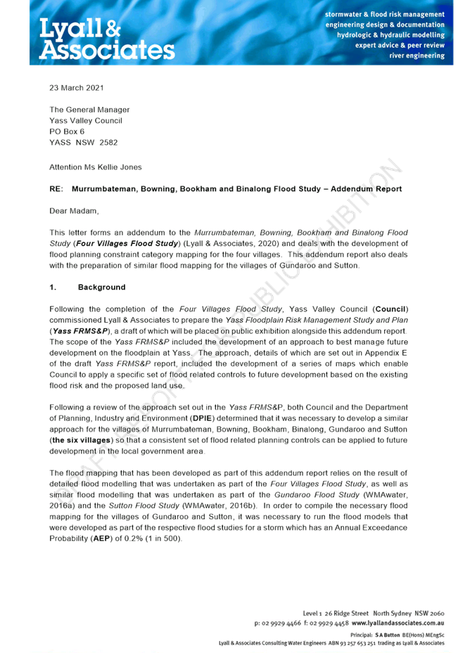
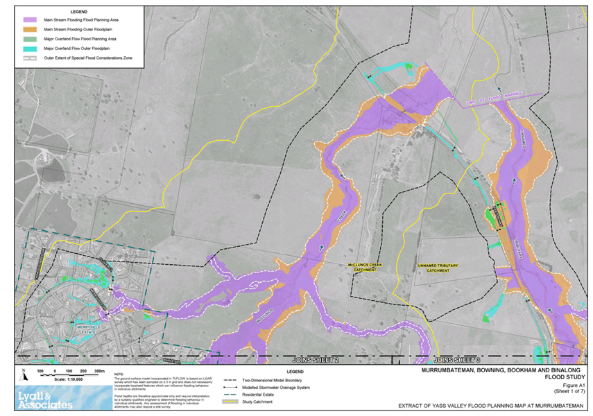
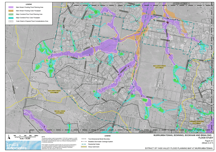
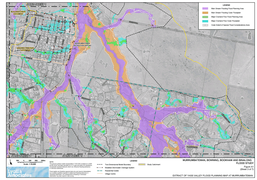
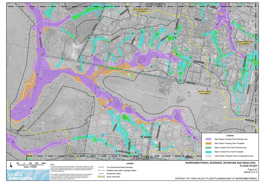
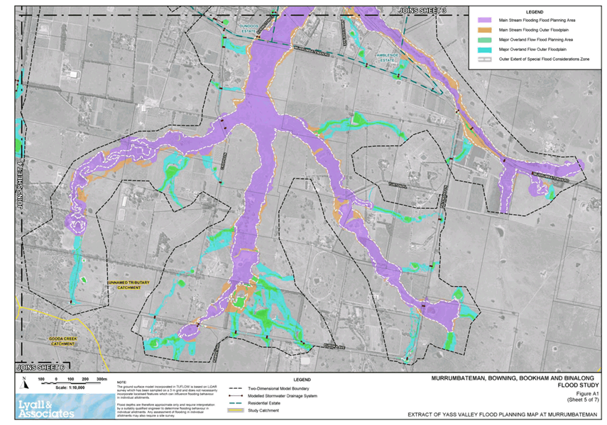
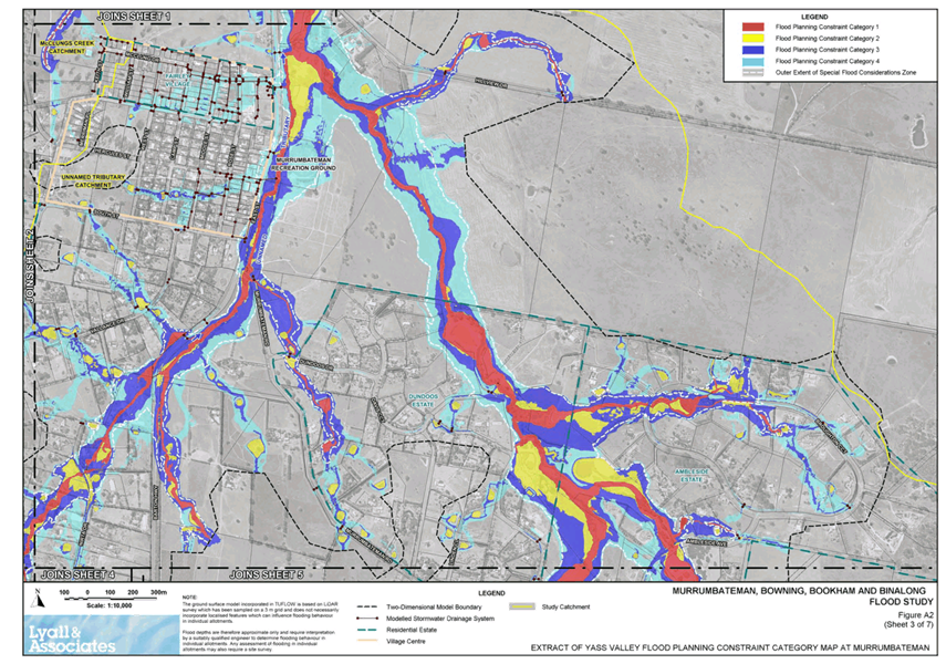
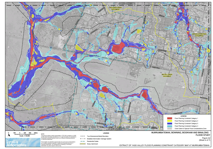
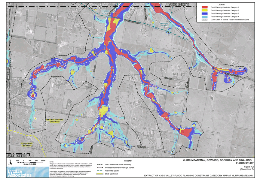
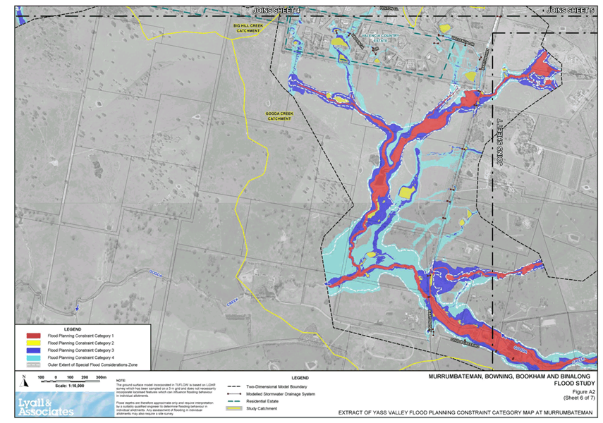
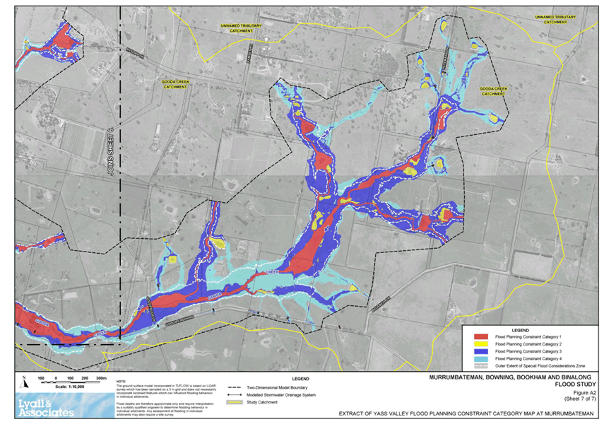
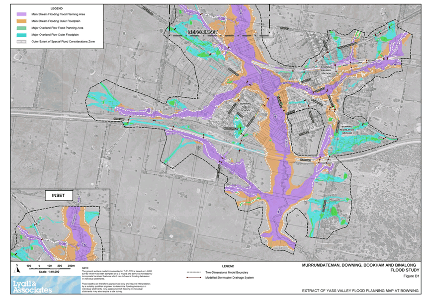
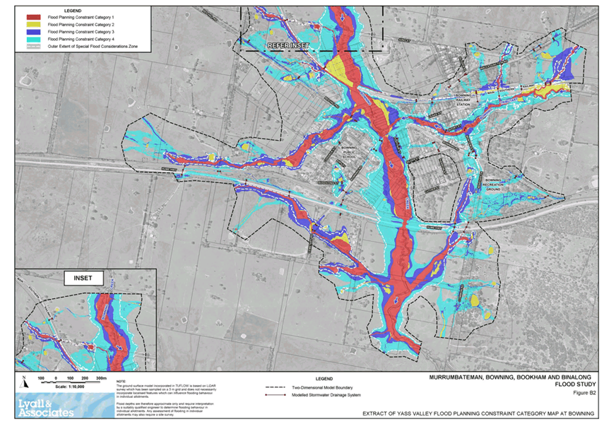
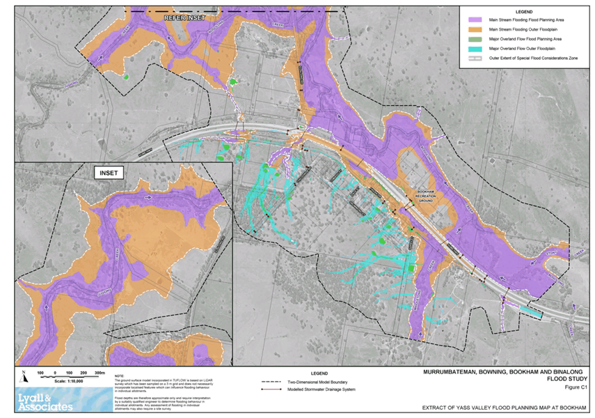
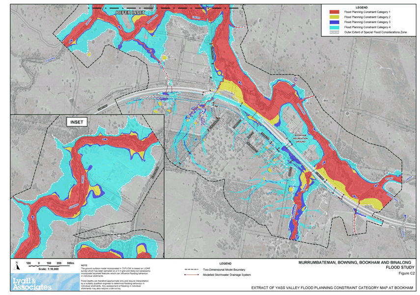
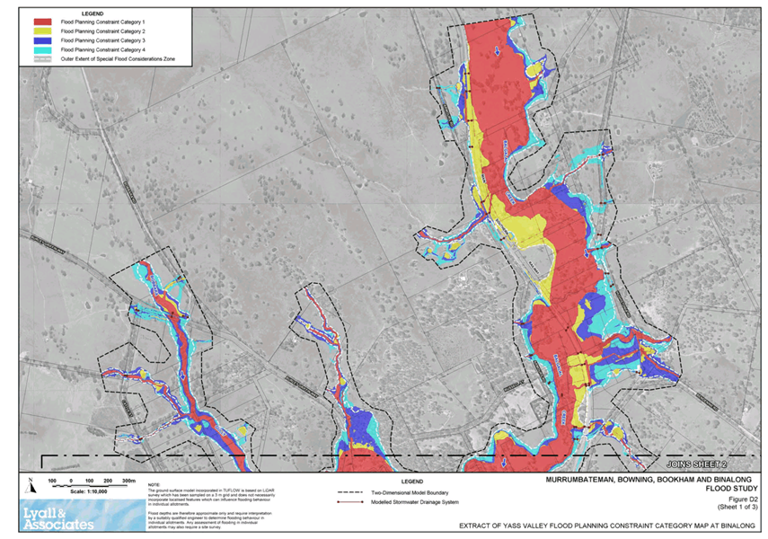
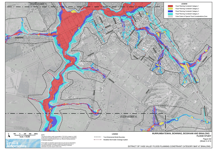
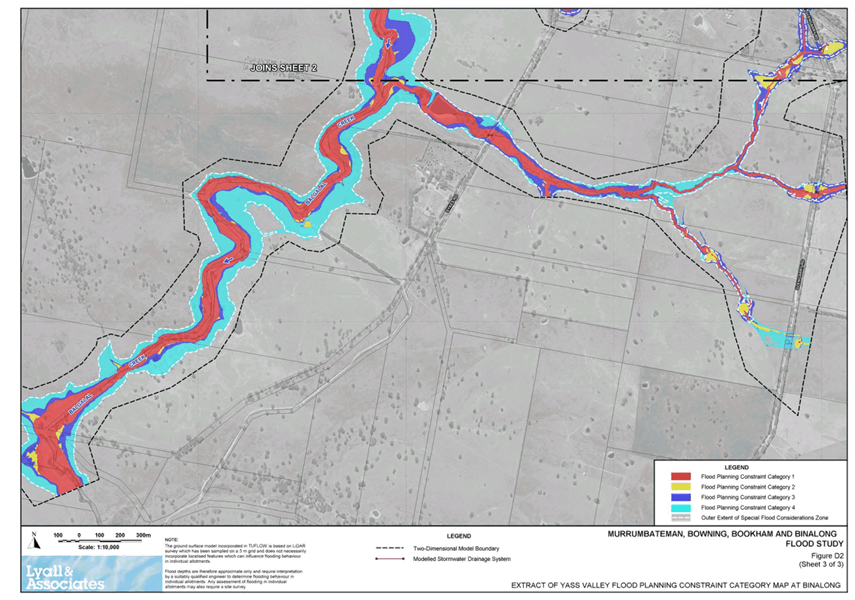
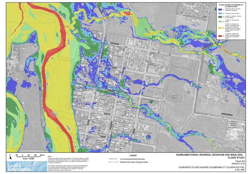
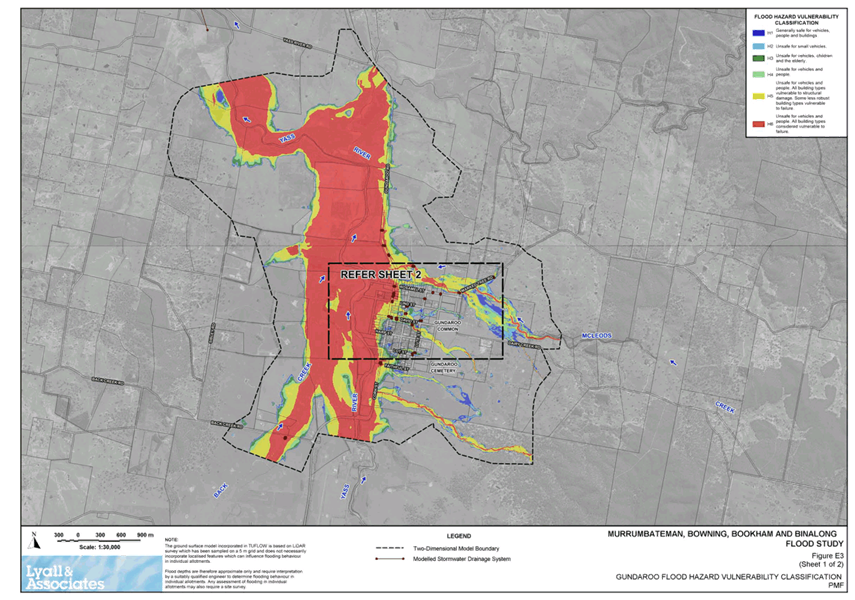
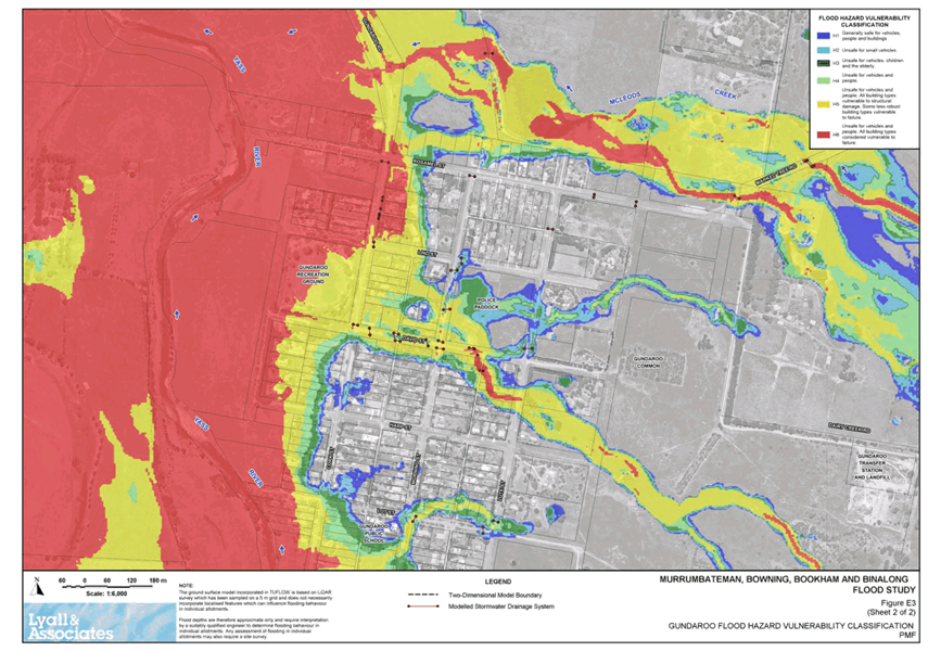
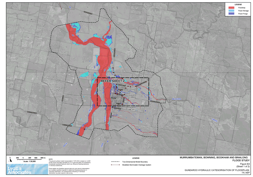
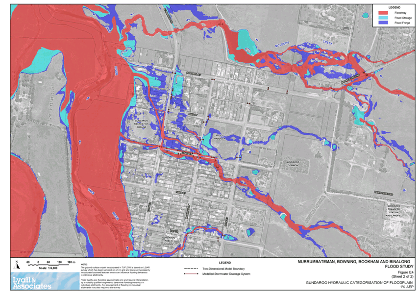
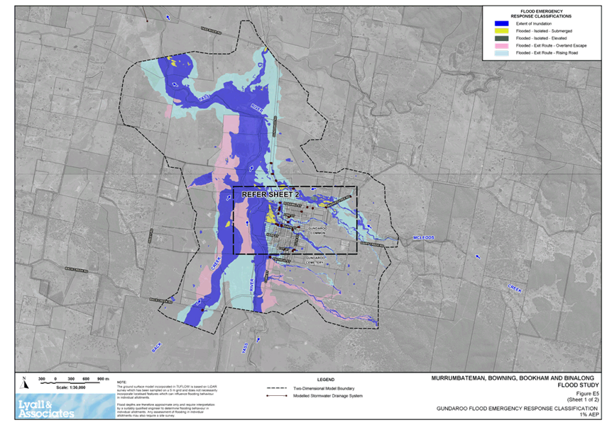
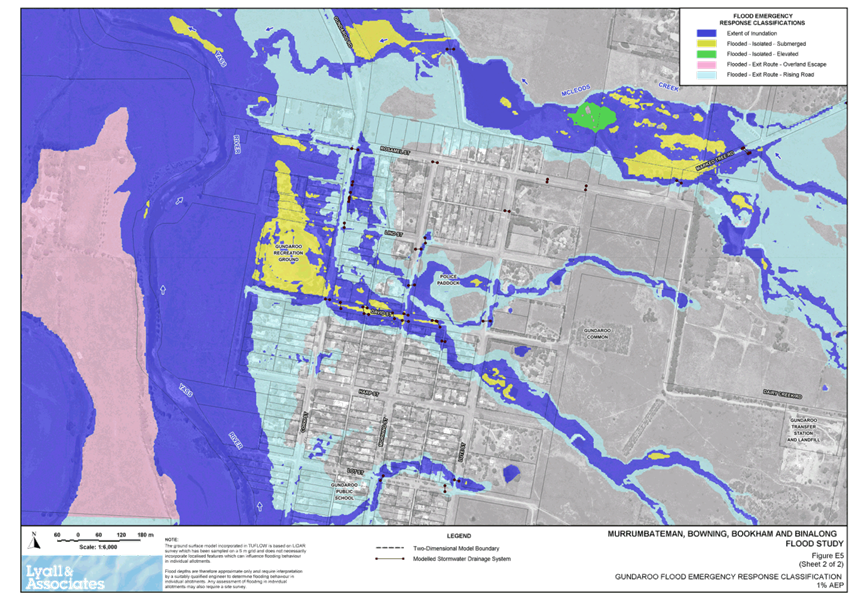
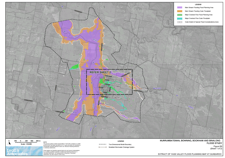
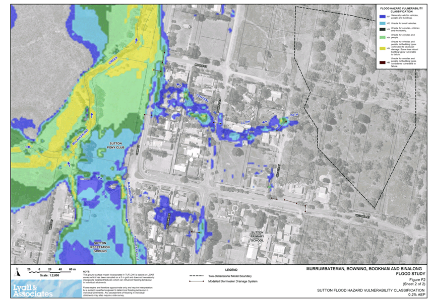
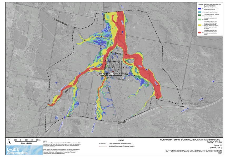
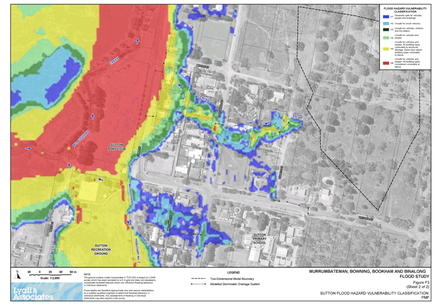
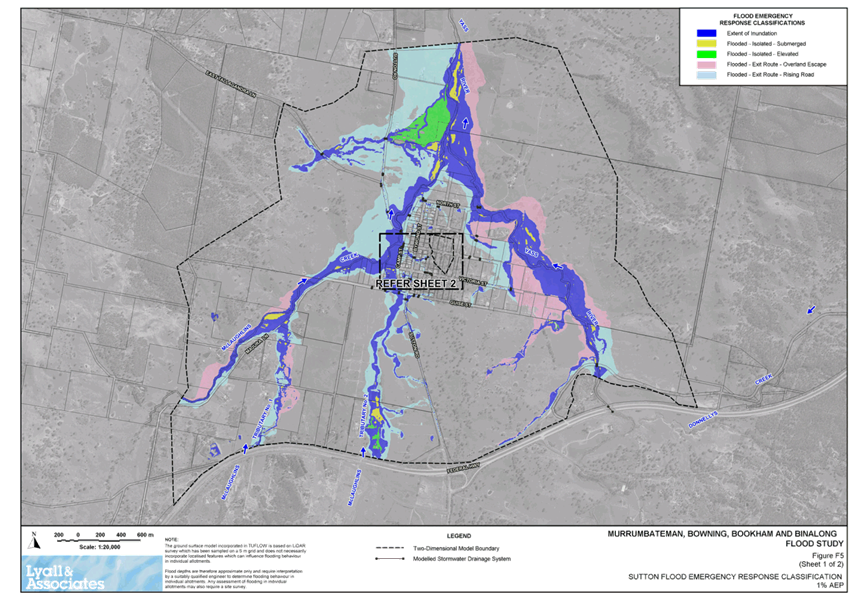
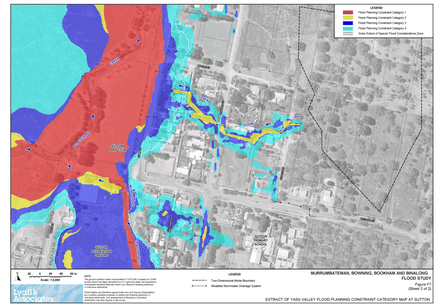
7.2 Flood Mapping Addendum for the Flood Studies Prepared for the villages of Murrumbateman, Bowning, Bookham, Binalong, Gundaroo and Sutton
To ensure a consistent set of flood related planning controls can be applied to future development in the local government area the flood studies prepared for the villages of Murrumbateman, Bowning, Bookham, Binalong, Gundaroo and Sutton have been review and are proposed to be updated.
RECOMMENDATIONThat the Flood Mapping Addendum for the Flood Studies prepared for the villages of Murrumbateman, Bowning, Bookham, Binalong, Gundaroo and Sutton be placed on public exhibition |
Nil as a result of this report.
· NSW Flood Prone Land Policy
Background
The NSW State Government’s Flood Prone Land Policy is directed at providing solutions to existing flooding problems in developed areas and to ensuring that new development is compatible with the flood hazard and does not create additional flooding problems in other areas. Under the Policy, the management of flood liable land remains the responsibility of Local Government. The State subsidises flood mitigation works to alleviate existing problems and provides specialist technical advice to assist Councils in the discharge of their floodplain management responsibilities. The Policy provides for technical and financial support by the Government through the following four sequential stages:
· Flood Study - determines the nature and extent of flooding
· Floodplain Risk Management Study - evaluates management options for the floodplain in respect of both existing and proposed development
· Floodplain Risk Management Plan - involves formal adoption by Council of a plan of management for the floodplain
· Implementation of the Plan - construction of flood mitigation works to protect existing development. Use of Local Environmental Plans to ensure new development is compatible with the flood hazard. Improvements to flood emergency management measures
In 2019/20 Council commenced the preparation of the Murrumbateman, Bowning, Bookham and Binalong Flood Study (MBBB Flood Study) and the Yass Floodplain Risk Management Plan and Study (Yass FRMS&P). These projects where jointly funded by Council and the NSW Government, via the Department of Planning, Industry & Environment (DPIE).
In June 2020 the draft MBBB Flood Study was reviewed by the Steering Committee and was placed on public exhibition from 16 June 2020 to 17 July 2020. No public submissions were received.
During this period work also commenced on the Yass FRMS&P. The approached used included the development of a series of maps which enable Council to apply a specific set of flood related controls to future development based on the existing flood risk and the proposed land use. Following a review of this approach with DPIE it was determined that it was necessary to develop a similar approached for the villages of Murrumbateman, Bowning, Bookham, Binalong, Gundaroo and Sutton. This would result in a consistent set of flood related planning controls can be applied to future development in the local government area.
Action Taken
Council, with the support of DPIE, have issued variations to the contractor developing the MMMB Flood Study to develop flood mapping for the villages of Murrumbateman, Bowning, Bookham, Binalong, Gundaroo and Sutton.
This flood study mapping work has been completed as an addendum document prepared (refer Attachments A and B). This Addendum was presented to the Steering Committee on 7 April 2021. The Steering Committee has endorsed the addendum to be referred to Council for public exhibition.
Once the addendum document has completed its exhibition and all submissions considered the flood mapping will then be:
· Added directly in the draft MMMB Flood Study and the updated document referred to Council for adoption
· Added as addendums to the existing Gundaroo and Sutton Flood Studies
Key Pillar 1. Our Environment
CSP Strategy EN4 - Maintain a balance between growth, development and environmental protection through sensible planning
Delivery Program Action EN4.1 - Ensure Council's statutory planning instruments are up to date and reflective of the community needs
Operational Plan Activity EN4.1.1 – Undertake ongoing strategic land use planning and reviews of existing instruments
ATTACHMENTS: a. Flood Mapping Addendum - Report ⇩
b. Flood Mapping Addendum - Figures ⇩
7.2 Flood Mapping Addendum for the Flood Studies Prepared for the villages of Murrumbateman, Bowning, Bookham, Binalong, Gundaroo and Sutton
Attachment a Flood Mapping Addendum - Report

7.2 Flood Mapping Addendum for the Flood Studies Prepared for the villages of Murrumbateman, Bowning, Bookham, Binalong, Gundaroo and Sutton
Attachment b Flood Mapping Addendum - Figures


7.3 Yass Flood Risk Manangement Plan & Study
A draft Yass Flood Risk Management Plan & Study has been prepared to assess the impacts of flooding, review existing Council policies as they relate to development of land in flood liable areas and to consider measures for the management of flood affected land.
RECOMMENDATIONThat the Yass Flood Risk Management Plan & Study be placed on public exhibition. |
Nil as a result of this report.
· NSW Flood Prone Land Policy
1. Background
The NSW State Government’s Flood Prone Land Policy is directed at providing solutions to existing flooding problems in developed areas and to ensuring that new development is compatible with the flood hazard and does not create additional flooding problems in other areas. Under the Policy, the management of flood liable land remains the responsibility of local government. The State subsidises flood mitigation works to alleviate existing problems and provides specialist technical advice to assist councils in the discharge of their floodplain management responsibilities. The Policy provides for technical and financial support by the Government through the following four sequential stages:
· Flood Study - determines the nature and extent of flooding
· Floodplain Risk Management Study - evaluates management options for the floodplain in respect of both existing and proposed development
· Floodplain Risk Management Plan - involves formal adoption by Council of a plan of management for the floodplain
· Implementation of the Plan - construction of flood mitigation works to protect existing development. Use of Local Environmental Plans to ensure new development is compatible with the flood hazard. Improvements to flood emergency management measures
In 2019/20 Council commenced the preparation of the Yass Floodplain Risk Management Plan & Study (Yass FRMP&S). This project is jointly funded by Council and the NSW Government, via the Department of Planning, Industry & Environment (DPIE).
The overall objectives of the project were to assess the impacts of flooding, review existing Council policies as they relate to development of land in flood liable areas, consider measures for the management of flood affected land and to develop the Yass FRMP&S, which:
· Proposes modifications to existing Council policies to ensure that the development of flood affected land is undertaken so as to be compatible with the flood hazard and risk
· Sets out the recommended program of works and measures aimed at reducing over time, the social, environmental and economic impacts of flooding
· Provides a program for implementation of the proposed works and measures
The study area for the Yass FRMP&S applies to areas that are affected by the following two types of flooding at Yass:
· Main Stream Flooding, which occurs when floodwater surcharges the inbank area of the existing river and creek systems. Main Stream Flooding is typically characterised by relatively deep and fast flowing floodwater, but may be shallower and slower moving in flood fringe areas
· Major Overland Flow which occurs during storms which result in the surcharge of the existing piped drainage system. It is also present in the upper reaches of the study catchments
The following map shows the area cover by the Yass FRMP&S.
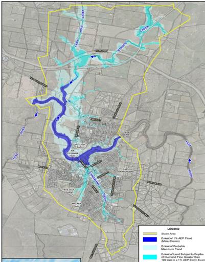
Yass FRMP&S – Study Area (more detailed maps can be found in Attachment B)
Prior to commencing the Yass FRMP&S it was determined that the Yass Flood Study required to be updated to add missing information, reflect changes in the Australian Rainfall & Runoff Manual and the potential impact of climate change.
The Yass FRMP&S has been prepared under the guidance of a Steering Committee comprising representatives from Council, the NSW Department of Planning, Industry & Environment, the NSW State Emergency Service and community representatives.
General community input to the project was obtained via hardcopy community newsletter (distributed to all residents in Yass township) and a questionnaire (hardcopy or on-line)
2. Action Taken
A draft Yass FRMP&S has been prepared, refer Attachments A and B (provided under separate cover).
The draft report identifies a number of priority flood management measure, which are estimated to cost approximately $7M. These measures can be broadly grouped as follows:
3. Flood Modification
Development and implementation of a Vegetation Management Plan for Chinaman’s Creek. This would require the removal of dense vegetation from the inbank area, which will significantly reduce the frequency of nuisance flooding and blockage risk of hydraulic structures.
4. Property Modification
· Update wording in the Yass Local Environmental Plan 2013
· Improvements to planning and development controls for future development in flood prone areas. This includes a graded set of planning controls for future development that recognises the location of the development within the floodplain and applied consistently across the whole of the LGA
· Potential inclusion of 12 properties identified at possible risk during serious flooding event in future rezoning plans or future NSW Government’s voluntary purchase or house raising schemes
5. Response Modification
· Improvements to emergency response planning including working with the SES to update the Yass Valley Local Flood Plan;
· Increase public awareness of the risks of flooding in the community. This may include working with the SES to prepare a Flood Information brochure;
· Investigation and design of an integrated flood warning system for the Yass Valley. This may include the installation of a network of pluviographic rain gauges, telemetered stream gauges etc. Council will be responsible for the maintenance of this network;
· Implementation of an integrated flood warning system for the Yass Valley.
The draft Yass FRMP&S was referred to the Steering Committee on the 25 March 2021. The Steering Committee has endorsed the draft plan to be referred to Council for public exhibition.
To ensure the community has adequate opportunities to be consulted on the draft Yass FRMP&S and its implications the following actions are also proposed:
· A newsletter be developed to explain the outcomes of the draft document in simple terms, which will be delivered to every household in Yass township including a feedback form
· An on-line information campaign will be developed by Council’s Communications Team
· A drop-in information session be arranged
· The 12 properties identified as at potential risk during a serious flood event will be separately and individually consulted
· 3-D modelling to show flood levels be investigated for inclusion in the consultation process
· Opportunities to physical mark the flood heights in Comur Street be investigated for inclusion in the consultation process
· All documentation will be available at the Council’s Customer Service Counter and on Council’s website
Key Pillar 1. Our Environment
CSP Strategy EN4 - Maintain a balance between growth, development and environmental protection through sensible planning
Delivery Program Action EN4.1 - Ensure Council's statutory planning instruments are up to date and reflective of the community needs
Operational Plan Activity EN4.1.1 – Undertake ongoing strategic land use planning and reviews of existing instruments
ATTACHMENTS: a. Draft Yass Flood Risk Management Plan and Study - Report (Under Separate Cover) ⇨
b. Draft Yass Flood Risk Management Plan and Study - Figures (Under Separate Cover) ⇨
Ordinary Council Meeting 28 April 2021
SUMMARY
To update Council on rate arrears to the end of the third quarter of the 2020/21 financial year.
Rate arrears totalled $1,129,323.95 as at 30 June 2020 and this has now been reduced to $569,722.80 as of 31 March 2021. This represents an improvement of $559,551.15 or 49.55%.
|
That the report on rates arrears be noted |
Financial IMPLICATIONS
Nil.
POlicy & Legislation
Rate arrears are closely monitored and debt recovery is fully compliant with Council’s Debt Recovery Policy.
REPORT Table 1 – Arrears as of 31 March 2021
|
|
Rates and Charges Levied (includes interest) |
Paid 1 July 2020 to 31 March 2021 |
Balance Outstanding |
% Paid 1 July 2020 to 31 March 2021
|
|
Arrears to 30/6/2020 |
$1,129,323.95 |
$559,551.15 |
$569,772.80 |
49.55% |
|
Current Years Rates, Charges and Interest billed since 1 July 2020 |
$18,393,401.03 |
$13,778,966.04 |
$4,614,434.99 |
74.91% |
|
TOTALS |
$19,522,724.98 |
$14,338,517.19 |
$5,184,207.79 |
73.45% |
Table 2 – Summary of Prior Year’s Outstanding Balance as of 31 March 2021
|
Year |
No of Assessments |
Amount |
Details |
|
2004/05 |
1 |
$201.52 |
Proposed Private Cemetery in Middle of Crown Land – Never Developed – No Burials (1) |
|
2005/06 |
1 |
$309.09 |
As Above |
|
2006/07 |
1 |
$342.02 |
As Above |
|
2007/08 |
1 |
$437.26 |
As Above |
|
2008/09 |
5 |
$2,373.52 |
As Above / Private Cemetery (2) / Pt Bendenine Rd (1) / Pt Riverbank Park (1) / Vacant Block Kangiara Village (1) |
|
2009/10 |
5 |
$3,497.44 |
As Above |
|
2010/11 |
5 |
$3,408.90 |
As Above |
|
2011/12 |
5 |
$3,923.27 |
As Above |
|
2012/13 |
5 |
$4,277.60 |
As Above |
|
2013/14 |
6 |
$4,628.24 |
As Above / 1 Property Subject of Ongoing Debt Recovery Action |
|
2014/15 |
8 |
$10,843.65 |
As Above / 2 Additional Properties Subject of Ongoing Debt Recovery action – Owner Declared Bankrupt |
|
2015/16 |
8 |
$11,518.39 |
As Above |
|
2016/17 |
13 |
$17,080.17 |
As Above /5 Additional Properties Subject of Ongoing Debt Recovery Action |
|
2017/18 |
35 |
$48,633.28 |
As Above / All Additional Properties With Either Payment Arrangements or Subject of Ongoing Debt Recovery Action |
|
2018/19 |
68 |
$107,744.00 |
|
|
2019/20 |
286 |
$350,554.45 |
|
|
|
TOTAL |
$569,772.80 |
|
Legend – (1) – Owner(s) Deceased – (2) – Company Deregistered
Many long term debts have now been either satisfied or have payment arrangements in place. It is proposed to review all eligible properties without payments agreements for overdue rates to be sold, in the second half of 2021 under s713 Local Government Act 1993.
Table 3 – Rates and Charges Levied and Payments Made 1 July 2020 to 31 March 2021
|
|
Rates and Charges Levied (includes interest) |
Paid 1 July 2020 to 31 March 2021 |
Balance Outstanding |
% Paid 1 July 2020 to 31 March 2021 |
|
1/7/17 – 31/3/18 |
$15,340,492.26 |
$11,530,058.84 |
$3,810,433.42 |
75.16% |
|
1/7/18 – 31/3/19 |
$16,595,896.76 |
$12,047,605.46 |
$4,548,291.30 |
72.59% |
|
1/7/19 – 31/3/20 |
$17,768,043.01 |
$13,298,450.37 |
$4,469,592.64 |
74.84% |
|
1/7/20 – 31/3/21 |
$18,393,401.03 |
$13,778,966.04 |
$4,614,434.99 |
74.91% |
Note: The prescribed period for not being able to commence the recovery of a rate or charge through legal proceedings under s747AB Local Government Act 1993 expired on 26 March 2021. Debt recovery action has now recommenced.
The rate arrears as of 30 June 2020 showed an outstanding balance of $1,129,323.95 which has now been reduced to $569,772.80 as shown in Table 1. The yearly breakup of these arrears is shown in Table 2.
The rates and charges Levied and the payments made up until the end of the third quarter is shown in Table 3. Also included are comparative figures for the previous three financial years. It can be seen that the percentage of rates and charges paid in this year’s third quarter compares favourably to previous years.
Key Pillar 5. Our Civic Leadership
CSP Strategy CL4 - Actively investigate and communicate funding sources and collaboration opportunities that can strengthen the region
Delivery Program Action CL4.1 - Monitor and distribute information from government agencies relating to funding opportunities
Operational Plan Activity CL4.1.1 - Provide information to community organisations on funding opportunities
Ordinary Council Meeting 28 April 2021
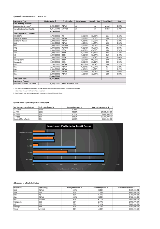
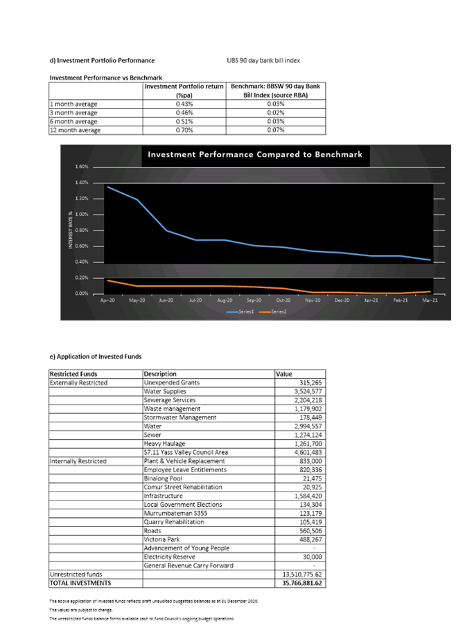
8.2 Investment and Borrowings Report - March 2021
SUMMARY
In accordance with the Clause 212 Local Government (General) Regulation 2005, this report provides a summary of Council’s investments as at 31 March 2021. In accordance with paragraph (1)(b), it can be certified that the investments listed have been made in accordance with the Act, the Regulations and Council’s Investment Policy.
|
That the Investment Report as at 31 March 2021 be received and it be noted that the summary has been prepared in accordance with the Act, the Regulations and Council’s Investment Policy. |
Financial IMPLICATIONS
Council’s investment portfolio provides funding for some projects identified in the Operational Plan.
POlicy & Legislation
· s625 Local Government Act 1993
· Clause 212 Local Government (General) Regulation 2005
· Investment Policy
REPORT
Comments on Economic Climate
The RBA held the cash rate at 0.10%.
Analysts upgraded forecasts for economic growth around the world. In some regions in Europe, new waves of COVID-19 infections were met with renewed restrictions on activity, but investors viewed these setbacks as temporary and markets were mainly unaffected.
US economic prospects were boosted by the passage of President Biden’s US$1.9 trillion stimulus package and potential for another US$2-4 trillion of spending on physical and social infrastructure over the next 8 years.
The improvement in economic conditions has been sufficient for some governments and central banks, notably China, to allow some emergency support measures to lapse, while still maintaining pro-growth fiscal and monetary policy settings overall.
The Australian economy has continued to recover with the unemployment rate dropping to 5.8% and strong demand pushed house prices up 2.8% in March 2021. The Government has allowed a number of support measures to lapse at the end of March 2021 including JobKeeper, the JobSeeker Supplement and HomeBuilder.
Council Investments
Valuations of Council investments are detailed in Attachment A.
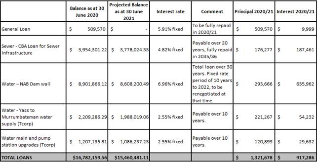
Council Loans
Council has five loans with balance owing as at 30 June 2020 of $16.782m. The table below provides loan details as at 30 June 2020. Indicative repayments for 2020/21 are shown for both principal and interest for all current loans. Balances will not change on a monthly basis as the most frequent repayment cycle is quarterly.
Key Pillar 5. Our Civic Leadership
CSP Strategy CL1 - Effect resourceful and respectful leadership and attentive representation of the community
Delivery Program Action CL1.6 - Maximise Council’s ability to generate income
Operational Plan Activity CL1.6.3 - Review commercial activities to ensure Council is maximising returns
ATTACHMENTS: a. March 2021 Investment Report ⇩
8.3 2021/22 Draft Operational Plan
SUMMARY
Council has used the Tablelands Regional Community Strategic Plan (CSP) and the 2017/18 – 2021/22 Delivery Program to prepare its 2021/22 Operational Plan. With the deferral of Local Government Election in 2020 for 12 months the Delivery Program was extended for a fifth year. The Delivery Program which clarifies the point where Council takes ownership of the Community Strategic Plan strategies that are within its area of responsibility.
Council’s Draft Operational Plan 2021/22 supports the Delivery Program and details the individual projects and activities that will be undertaken for 2021/22 to achieve the commitments made in the Delivery Program.
Council’s approval is sought to place the Draft Operational Plan 2021/22 on public exhibition.
|
That the Draft Operational Plan 2021/22 be placed on public exhibition |
Financial IMPLICATIONS
The Operational Plan establishes Council’s annual operational and budget priorities and the financial impacts are contained within this document.
POlicy & Legislation
· Local Government Act 1993
· Local Government General Regulations 2005
· Local Government Amendment (Governance & Planning) Act 2016
· Integrated Planning and Reporting Framework
REPORT
1. Integrated Planning and Reporting Framework
The Integrated Planning and Reporting (IR&R) Framework came into practice in 2009 and established the way in which Councils plan, document and report on their plans for the future. The framework is summarised in the following diagram:
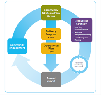
The frameworks provides for:
· The Community Strategic Plan which outlines the community aspirations for the next 10-20 years. This is a whole of community document and is reviewed following each Local Government election.
· The Delivery Program details Council’s key activities to undertake over its four year term of office
· Supporting the Delivery Program is the Resourcing Strategy comprising of the Long Term Financial Plan, Workforce Management Plana and Asset Management Planning.
· An annual Operational Plan detailing Councils work activities forward achieving the Delivery Program.
· A six monthly Performance Report and the Annual Report detail Council’s progress in its achievements under the IP&R Framework
The interrelationship between the Community Strategic Plan, Delivery Program and Operational Plan is outlined in the following diagram:
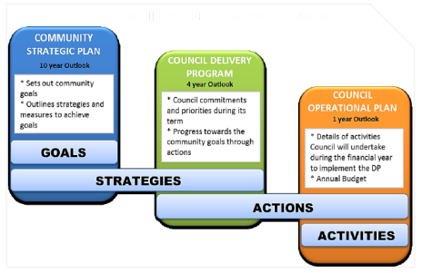
While the Community Strategic Plan, Delivery Program and Operational Plan are interrelated they are presented as individual documents. For a complete picture it is important that the suite of documents are read as a package and not in isolation.
2. Draft Operational Plan 2021/22
The Operational Plan (refer Attachment A) supports the 2017/18 – 2021/22 Delivery Program and sets out Council’s planned activities for 2021/22. The Operational Plan identifies the individual projects and activities that will be undertaken within the next financial year to achieve the actions described in the Delivery Program. The Operational Plan allocates responsibilities for each activity and identifies how their effectiveness will be measured.
The Operational Plan includes Council’s statement of revenue policy (including the proposed rating structure), draft 2021/22 fees and charges, the detailed annual budget (including identified projects) and the updated long term financial plan.
3. Assumptions
In preparing the draft Operational Plan the following assumptions have been made:
· 2.0% wage increase
· 2.0% rate pegging increase
· Interest rates at 7.0%
· Federal Assistance Grants of $3.2M
4. Priority Infrastructure
Council identified several key infrastructure projects and priorities for the upcoming financial year. The objective of these priorities is to commence the planning process to ensure that the projects are ‘shovel ready’ should:
· Grant funding opportunities arise
· Council’s existing loans mature freeing up funds to service new loans
· Other funding becomes available through surplus land sales
The priority projects identified include:
· Civic Precinct
· Yass War Memorial Swimming Pool redevelopments
· Murrumbateman Community Hall
· Amenities at the Yass Pool/Skate Park, Murrumbateman and Yass CBDs
· New Companion Animals Facility
· Parks and playgrounds upgrades
· Bike park, Adventure Playground and Yass River activation
· Memorial Hall
· Murrumbateman Dog Park
A number of these projects have been started in the 2020/21 financial year and will carry forward into the 2021/22 financial year. The projects include:
· Bango Bridge
· Illalong Road
· Yass River Road
· Moreton Avenue
· Walls Junction Road
· Cusack Place
· Faulder Avenue
· Good Hope Road
· Fixing Local Roads Grant – resealing program
· Resheeting program:
- Back Creek Road
- Bango Lane
- Casey Close
- Connells Lane
- Coolalie Road
- Dicks Creek Road
- Dog Trap Road
- Gums Lane
- Longraill Gully Road
- Lucernvale Road
- Old Gap Road
- Springrange Road
- Tallagandra Lane
- Yass River Road
· Murrumbateman Sand Arena stabilisation, Recreation Grounds Dog Park, Recreation Grounds Amenities, Equestrian Ground/Oval Upgrade and Recreation Grounds Club House
· Walker Park Sporting Complex Improvements
· Council Administration Complex, library and commercial space
Due to budgetary constraints a number of identified projects have been cut from budget until further funding can be sourced. Some of these projects are subject to grant funding approval. Once approval has been granted, these will be included in the budget throughout the year. These include:
· Fixing Local Roads rehabilitation and resealing program
· Bridge renewal for Greenwood Road
· Sealing an unsealed section of road
· Scanes Road Culvert Upgrade
· David Street Footpath, Gundaroo
· Safety around schools, Gundaroo
· Safety around schools, Berinba – shared path
· Flood detention basin, Gundaroo
· Shade sails in LGA playgrounds
· Public Space Legacy Program
5. Fees & Charges
Fees and charges for 2021/22 have been based on the relevant revenue policy. Broadly these fall into three categories i.e.
· Regulatory fees
· Contestable fees
· Other fees
Regulated fees are directly linked to the relevant State legislation and only change if the legislation changes.
Contestable fees are based on the principles of competitive neutrality and include direct costs, a portion of corporate overheads and a profit margin. These fees cannot be cross subsidised. Any changes are based on the estimated staff time involved in providing the service.
Other fees and charges have been increased in line with the movement of wage costs (i.e. 2%). As the charges are related to Council staff providing a service, wages are the key driver of any change. These fees have been raised in line with the projected 2% wage growth.
The COVID-19 pandemic has impacted on the local economy through the closure of businesses, loss of employment, banning of events and gatherings. While COVID-19 restrictions have eased the Hardship Policy remains in place to provide a local response to those continuing to experience problems.
6. Key Features of the Draft Budget 2021/22
Consultation was undertaken with community groups to assist with identifying for consideration as part of the Operational Plan and Budget. The following groups input into this process:
· Mt Spring Association
· Bowning Community Association
· Wee Jasper Community Association
· Sutton Community Association
· Binalong Community Association
· Murrumbateman Progress Association
· Bookham
While a number of issues had been identified, due to budgetary constraints we needed to prioritise these projects. A number of projects have been identified as being works to be undertaken when funding can be sourced. Some of these include:
· Stage 1 Bookham Streetscape
· Cloth nappy rebate program
· Disability Inclusion Action Plan 2021/24 – to be undertaken in house
· Reduction to the Roadside Reserve Priority Weed Control program in the first year, while additional funding is sourced for a more extensive program
· Reduction to the Desexing Program in the first year, while additional funding is sourced
· Reduction to the Plan for a new Companion Animal Facility as this project is staged and further funding can be sourced
· Reduction to the Yass Mainstreet Street Space Plan, Yass Valley Space Strategy and Village Masterplan as we attempt to source additional funding for these projects
Due to budgetary constraints some additional costs were required to be cut from the budget. A number of currently vacant positions and proposed new positions within the Council structure have been removed from the budget until cost savings can be identified. These include:
· Customer service team leaders, including a role in the Planning & Environment Division
· Trainee/apprentice roles in Records/IT, Payroll and Workshop
· Economic Development Officer and Community Planner
· Design Engineer
· Water Cart and Loader Operator
The Net Operating Result before Capital Grants is a surplus of $32,000.
7. Financial Ratios
All financial ratios are within benchmarks, except for the Operating Performance Ratio. This has dropped to -1.35% in 2021/22 due to increased expenditure to undertake the projects identified in the Operational Plan.
Financial Ratios
|
Ratio |
Benchmark |
2021/21 Draft Budget |
2020/21 Original Budget |
2019/20 Actual |
|
Operating Performance |
> 0% |
-1.35% |
0.43% |
12.08% |
|
Own source Revenue |
> 60% |
65.58% |
61.15% |
60.23% |
|
Debt Service Ratio |
> 2.00x |
2.97x |
2.18x |
3.20x |
|
Cash Expense Cover ratio |
3.0 months |
8.14 months |
8.16 months |
9.37 months |
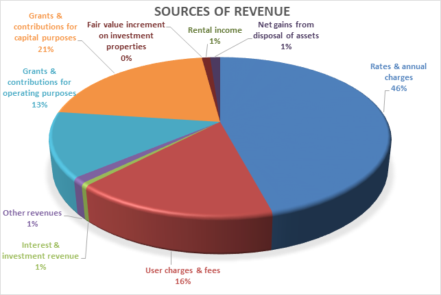
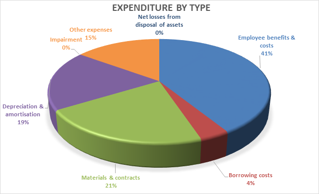
8. Community Engagement
The 2021/22 Operational Plan is to be placed on exhibition and community engagement undertaken in line with a Plan developed in accordance with the Community Engagement Strategy.
In previous years this engagement process included ‘roadshow’ style presentations to a number of groups and the general community to explain the content of the plan and inform community members regarding the opportunities to make submissions.
Unfortunately the COVID-19 pandemic and the ensuing Public Health Orders will prevent to ‘roadshow’ meetings as facilitated in previous years due to the ongoing limits on the capacity of venues. An alternate delivery of the presentation via a pre-recorded presentation that can be distributed on line is being planned.
Direct notification of the public exhibition will also be sent to each community association along with a media campaign.
9. Next Steps
Any submissions received will be considered and changes made to the draft document where required. A report is scheduled to be prepared for the June 2021 Council meeting to consider the final adoption of the 2021/22 Operational Plan.
Key Pillar 5. Our Civic Leadership
CSP Strategy CL1 - Effect resourceful and respectful leadership and attentive representation of the community
Delivery Program Action CL1.4 - Be compliant, more efficient and effective
Operational Plan Activity CL1.4.2 - All regulated compliance is adhered to
ATTACHMENTS: a. Draft Operational Plan (Under Separate Cover) ⇨
Ordinary Council Meeting 28 April 2021
9.1 Yass to Murrumbateman Water Supply Pipeline - Easement Acquisition
The Yass to Murrumbateman water supply pipeline was constructed through 28 properties. Agreements have been reached with all property owners for an easement over the constructed pipeline other than one owner. Unfortunately, agreement has not been reached with this owner despite extensive correspondence between the owner and Council over the past 12 months. To resolve this impasse steps to compulsory acquire the easement have commenced.
Cost of the acquisition and creation of the easement is accounted for within the current project budget line.
· Local Government Act 1993
· Land Acquisition (Just Terms Compensation) Act 1991
In August 2017 Council determined to provide delegation to the General Manager and Mayor under s377 Local Government Act 1993, to execute a Deed of Agreement Release and Indemnity with each landowner for the purpose of acquiring an easement over land for the construction and operation of the Yass to Murrumbateman water supply pipeline and associated infrastructure.
In August 2018 Council determined to commence compulsory acquisition for an easement over the Yass to Murrumbateman Water Supply Pipeline.
As at December 2018, there were three remaining properties without an agreement and Council resolved to compulsorily acquire the easement, should the negotiations fail. Agreements were reached with the three landowners in August 2019.
Construction of Yass to Murrumbateman Pipeline commenced in July 2019 and completed in December 2019. The pipeline was constructed through 28 properties. Of those, 25 properties are privately owned by 16 landowners. Council owns the three remaining properties.
While agreement had been reached with the former landowner of 298 Dog Trap Road (i.e. Lot 113 DP1167373) the current landowners have sought a review.
A progress report on progress with the negotiations is included in the Closed Session of this meeting for consideration.
Key Pillar 4. Our Infrastructure
CSP Strategy IN5 - Ensure high quality water supply options for the towns in the region
Delivery Program Action IN5.1 - Council to supply quality water, cater for growth and quality enhancements that addresses the community needs
Operational Plan Activity IN5.1.1 Council to supply quality water, cater for growth and quality enhancements that addresses the community needs
Ordinary Council Meeting 28 April 2021
9.2 Quotation Evaluation Report - Supply and Delivery of Motor Grader
SUMMARY
This report provides advice on the recent Request for Quotation for Contract YVC - IA - 06 - 2020 Supply and Delivery of a Motor Grader.
|
This item be classified CONFIDENTIAL in accordance with Section 10A(2)(di) of the Local Government Act 1993, which permits the meeting to be closed to the public for business relating to commercial information of a confidential nature that would, if disclosed would prejudice the commercial position of the person who supplied it |
Financial IMPLICATIONS
The tendered price falls within the allocated 2020/21 budget for the replacement of this Grader.
Ongoing maintenance, repairs and other running costs are captured in the annual fleet maintenance budget and are not expected to increase based on this replacement.
POlicy & Legislation
· Local Government Act 1993
· Local Government (General) Regulation 2005
· Procurement Policy
REPORT
1. Background
The existing Komatsu GD555 Grader (P0124) has been identified as per the 10 Year Fleet Replacement Plan to be replaced during the 2020/21 Financial Year.
This particular procurement represents the replacement Grader to this machine.
This Grader is used for the Annual Maintenance Grading Program, maintaining Council’s unsealed Road network.
2. Quotations
The Request for Quotations (RFQ) was advertised to five pre-approved suppliers on the Vendor panel platform using the established Local Government Procurement Contract for Plant, Machinery and Equipment (LGP419)
Quotes were called on 10 December 2020 and closed on 5 January 2021. Three quotes were received from the following organisations:
|
Organisation |
Address |
|
RDO Equipment Pty Ltd – John Deere 670GP |
45 Eastern Creek Dr, Eastern Creek Sydney NSW 2766 |
|
Westrac Equipment Pty Ltd – CAT 140 (In stock ACT) |
78 Sheppard St, Hume ACT 2620 |
|
Westrac Equipment Pty Ltd – CAT 140 (Factory order) |
78 Sheppard St, Hume ACT 2620 |
A report on the Quotation evaluation is included in the Closed Session of this meeting for consideration.
Key Pillar 4. Our Infrastructure
CSP Strategy IN3 - Maintain and improve road infrastructure and connectivity
Delivery Program Action IN3.1 - Deliver transport asset infrastructure, maintenance, renewal and enhancement programs for urban, rural and regional roads to maintain or improve overall condition
Operational Plan Activity IN3.1.3 - Implement sound asset management practices in accordance with industry standards
Ordinary Council Meeting 28 April 2021
11.1 Questions With Notice - Cr Geoff Frost
The following Questions on Notice have been received from Councillor Frost:
1. When do staff expect to receive the engineer’s report relating to the state of repair of the Memorial Hall? Can Council be assured that this report will provide a practical basis for estimating the cost of repairs and developing a strategy for restoring the Hall to a satisfactory condition?
2. What insurance is held by Council regarding water damage to the Memorial Hall? Will the Council be able to claim against this insurance cover with respect to any recent damage to the Hall and its contents – including any damage to the contents of the Archives?
3. What are the current arrangements for cleaning in the Memorial Hall and the community centre? What checks are made to ensure these facilities are in a clean state for users?
4. Are staff aware of water leaks leading to a deterioration in the condition of the ceiling in the community centre? What action has been taken to ensure the leaks are fixed and the ceiling is satisfactorily repaired?
5. Staff have been informed by neighbours that stormwater from the new Hume Street subdivision is causing flooding and erosion damage on their property and to the Reddall Street road reserve. Have staff been able to ascertain what the problem is with the stormwater system and why it does not seem to be able to cope? Why is stormwater from the subdivision directed to an artificial channel in the Reddall Street road reserve which results in water running onto the Reddall Street and then to Glebe Street and not to the nearby natural watercourse? Is there a long term plan to fix the stormwater issues in this area? Why has it taken so long to provide temporary repairs to the Reddall Street road surface?
6. Is there a link between the recent release of untreated effluent from the Molonglo Sewerage Treatment Plant and the algal blooms in Burrinjuck Dam? What discussions have occurred with the ACT government to ensure there is not another such release?
Response
1. When do staff expect to receive the engineer’s report relating to the state of repair of the Memorial Hall? Can Council be assured that this report will provide a practical basis for estimating the cost of repairs and developing a strategy for restoring the Hall to a satisfactory condition?
Peak Consultants Pty Ltd -Structural Engineers have been appointed to undertake all the structural, electrical, asbestos, floor and sub floor condition reporting as well as safety and fire compliance checks, load limit testing will be carried out on the upstairs level as per the recommendation in the minutes of the Yass Soldiers Memorial Hall Committee. Consultants are due to start mid-April 2021 with final report due mid to end of June 2021.
The consultant’s report will provide priority repairs based on safety and compliance and urgent work required to be carried out to prevent further damage to the building.
Prioritised costing estimates for repairs and making code compliant will be included in the report.
2. What insurance is held by Council regarding water damage to the Memorial Hall? Will the Council be able to claim against this insurance cover with respect to any recent damage to the Hall and its contents – including any damage to the contents of the Archives?
Council is investigating insurance cover on the ceiling damage. It is unlikely that the floor and subfloor damage will be covered under insurance.
Council does not insure for damage to occupants’ contents - it is the responsibility of the occupant to have their own appropriate insurance cover.
3. What are the current arrangements for cleaning in the Memorial Hall and the community centre? What checks are made to ensure these facilities are in a clean state for users?
The Community Centre is scheduled for under the Cleaning Contract for a weekly clean and, as reported to Council in March 2021, it has been agreed that the Yass Memorial Hall is placed on a programmed fortnightly schedule. Staff will check the Memorial Hall prior to bookings.
Previous discussions with the Cleaning Contractor has resulted in regular random audits of buildings and amenities to ensure compliance with Key Performance Indicators in the contract. Any unsatisfactory findings will be conveyed to the contract manager for rectification in the first instance. Contract management processes are in place and monitored by the Manager Building Maintenance.
4. Are staff aware of water leaks leading to a deterioration in the condition of the ceiling in the community centre? What action has been taken to ensure the leaks are fixed and the ceiling is satisfactorily repaired?
Staff are aware of the water leak in the roof of the community centre and the site has been inspected to access the source of the water leak. Repairs will be undertaken to replace the broken roof tiles and associated ceiling repairs.
5. Staff have been informed by neighbours that stormwater from the new Hume Street subdivision is causing flooding and erosion damage on their property and to the Reddall Street road reserve. Have staff been able to ascertain what the problem is with the stormwater system and why it does not seem to be able to cope? Why is stormwater from the subdivision directed to an artificial channel in the Reddall Street road reserve which results in water running onto the Reddall Street and then to Glebe Street and not to the nearby natural watercourse? Is there a long term plan to fix the stormwater issues in this area? Why has it taken so long to provide temporary repairs to the Reddall Street road surface?
Reddall Street runs from Laidlaw Street to Cooks Hill Road. Reddall Street from Glebe Street to Cooks Hill Road is unformed.
The section of Reddall Street from Cooks Hill Road to Ford Street has no formal drainage infrastructure. It drains water from near the water treatment facility plus the water that discharges from the detention pond associated with the Discovery Drive subdivision.
Plans of the drainage flows along Reddall Street are included in Attachment A.
The section of Reddall Street from Ford Street to Hume Street has the stormwater infrastructure associated with Discovery Drive located in it and no other stormwater infrastructure. This discharges into Reddall Street just west of Hume Street.
The section of Reddall Street from Hume Street to Glebe Street is partly unsealed from Glebe Street to Lot 14 Reddall Street. The remainder of this section has no formal road infrastructure (there are two driveways leading off Hume Street) This section has no formal drainage infrastructure. The stormwater in this section was partly diverted to a dam located on a vacant lot (Lot 12) using a levy that was located partly across the unformed section of Reddall Street. The overflow from this dam previously discharges into an informal open drain (not maintained by Council) that runs to Glebe Street. Lot 12 with the dam has been sold and the dam has now been filled. The levy that divert the water off Reddall Street has been removed.
The section of Reddall Street from Glebe Street to Laidlaw Street is via an open drain recently created by the subdivision that is partly occupied by the Landmark building. This section of Reddall Street is sealed with kerb and gutter.
Stormwater issues (including flooding) have been a problem for the Reddall Street near Glebe Street for some time primarily due to the inadequate and/or lack of drainage infrastructure to manage the stormwater form the upstream catchment.
The development on Reddall Street near Hume Street was based on the majority of water on the site being divert to an on-site detention pond, which discharges to the informal stormwater system in Reddall Street. The purpose of the detention basin is to ensure post and prep development stormwater discharge from the site are the same.
The removal of the dam (on Lot 12) and the associated levy has meant that the stormwater in this section of Reddall Street has changed with the majority of the water now running down the centre of the unformed section of Reddall Street. When the stormwater gets to Lot 14 Reddall Street it splits with some going to the existing informal open drain on the southern side of Reddall Street and the remainder towards the entrance of Lot 14 Reddall Street.
The stormwater that diverts towards Lot 14 Reddall Street has no discharge point and makes the area near the driveway boggy and deep ruts have appeared. In addition, the landowner has advised that his property is also getting increase overland flow form the development site which eventually discharges on the northern side of Reddall Street just upstream of the driveway at 14 Reddall Street. This further exacerbates the stormwater problem.
Since Yass have been in an unusually wet period the amount of stormwater has significantly increased and the any shortfall in the drainage systems have been highlighted. This is the case in this area.
In relation to diverting all the water to the informal southern drain in Reddall Street, this could be done however the drain would have to have significant maintenance and increased in capacity to be able to manage the water. Then we would have to undertake significant new drainage infrastructure to get this water under Glebe Street and into the new open drain. No analysis has been undertaken on what the impact would be on the formal open drain particularly with the constraint at Laidlaw Street
The solution currently being examined is to formalise the road and drainage infrastructure further upstream (i.e. eastwards) of 14 Reddall Street so the water will not collect at their driveway and the area would be sealed.
Designs for this have commenced however whether it will proceed will depend on funding.
Temporary repairs were recently done after the landowner reported the impact of the recent storms. No work was undertaken prior to this as the access was considered to be in an acceptable condition.
6. Is there a link between the recent release of untreated effluent from the Molonglo Sewerage Treatment Plant and the algal blooms in Burrinjuck Dam? What discussions have occurred with the ACT government to ensure there is not another such release?
Water NSW reported blue green algae blooms at Burrinjuck Dam from late January 2021. The reports were for a Red Alert for the whole dam.
A Red Alert level warning indicates that people should not undertake recreational activities where they may be coming into direct contact with the water such as swimming, as well as domestic uses including showering and washing. Contact with the water may also pose a threat to livestock and pets.
On 23 February 2021 Water NSW reported that the Red Alert warning for blue-green algae for Burrinjuck Dam at Good Hope has been lifted following two consecutive algal sample results of lower than red alert level. The site is now on Amber Alert for blue-green algae.
While on an Amber Alert, the water is generally considered to be suitable for water sports, but water users are advised to exercise caution. It is also advised not to drink untreated or boiled water from this sampling site due to the risk of stomach upsets. Boiling the water does not inactivate algal toxins. The water should be considered unsuitable for potable use and alternative supplies or prior treatment of raw water for domestic purposes should be considered.
The latest alerts on the Water NSW web site (accessed 12 April 2021) indicate Amber Alert warnings remain in place at Burrinjuck Dam.
On 23 March 2021 Icon Water reported that due to the heavy rain over the previous two days entering the sewerage system, the Lower Molonglo Water Quality Control Centre treatment plant was expected to discharge a small amount of partially treated effluent into the Molonglo River.
The majority of the flow that was to be discharged continue to be fully treated and fully disinfected, with only a small portion of partially treated effluent that was not fully disinfected. The proportion of this in relation to flows within the river system is less than 2% of the Molonglo River flow, and less than 0.5% of the Murrumbidgee River flow.
Icon Water advised residents on the section of the Murrumbidgee River, from the junction of the Molonglo River and above Burrinjuck Reservoir, not to draw water from the river for either potable (drinking or food preparation) or non-potable (domestic or stock watering) purposes for the next 48 hours. Icon Water also advises against swimming and other bodily contact water sports in this section of Murrumbidgee River over this period.
The Icon Water discharges into the Murrumbidgee River occurred after the algae alerts for Burrinjuck Dam were downgraded to Amber and there has been no changes to these alerts since.
No discussions have occurred with the ACT Government. However, Icon Water has provided the following advice:
We are happy to report that our bypass storage dam did not overflow during the significant rain event in March and there were no releases of partially treated effluent, although all relevant notifications (media release and contact with downstream users) were provided as a precautionary measure. Therefore, as your email has suggested, release of partially treated effluent from Lower Molonglo Water Quality Control Centre (LMWQCC) is not believed to have contributed to algal blooms in Burrinjuck Dam.
In the interest of protecting the downstream environment we are committed to maintaining the effectiveness of treatment processes. As you are aware there is potential for the storage dam to reach the maximum capacity, due to a severe wet weather event. In 1997 the current storage dam was constructed to assist in attenuating peak wet weather flows. In the case that flows through the plant exceed the primary, secondary or tertiary treatment process capacity, partially treated effluent is diverted to the dam for temporary storage. When flows to the plant reduce to within rated capacities and operational performance permits, the stored effluent is then returned to the process for treatment. Icon Water’s objective is to maximise the water quality of the effluent diverted to the storage dam. Therefore, during a high flow event, a cascading approach of diversions through the process is adopted if needed. It is estimated that likely frequency will be less than one spill event every six years. Since the completion of the dam, there have been four spill events associated with wet weather events (December 2010, March 2012, September 2016 and August 2020). In the unlikely event of a spill, partially treated effluent will be released from the dam via the spillway discharge structure. Should this be anticipated, it is our standard response to establish an incident management team to manage the event by optimising performance of the plant and ensuring appropriate communications to those who may be impacted.
Our website includes information on our treatment processes and obligations that may be of interest to your Councillor or members of the public.
ATTACHMENTS: a. Drainage Path along Reddell Street ⇩
11.1 Questions With Notice - Cr Geoff Frost
Attachment a Drainage Path along Reddell Street
Reddall Street Stormwater flow prior to the removal of the dam on Lot 12
2004 Aerial showing drainage of Reddall Street primarily via a centre drainage course with some water divert to the dam on Lot 12
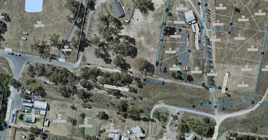
2015 Aerial Showing drainage of Reddall Street primarily via a centre drainage and some water divert to the dam
12.1 Minutes of the Canberra Region Joint Organisation Board Meeting held on 26 March 2021
REPORT
The minutes of the Canberra Region Joint Organisation (CRJO) Board meeting held on 26 March 2021 are included in Attachment A.
From these minutes there are two items which cover matters that:
· Requires expenditure not provided for in the current Operational Plan
· Involves a variation to a Council policy
· Is contrary to a previous decision or position of Council
· Relates to a matter which requires Council to form a view or adopt a position
· Deals with a matter of specific interest
1. Training for New Councillors
The CRJO sought quotations from the Australian Institute of Company Directors (AICD) for a coordinated training package for incoming Councillors across the CRJO network. While the training is aimed at new CRJO Board members the option of a separate training course for new Councillors was also sought i.e.
· A 1-day CRJO board essentials course encompassing a governance workshop, moving to a discussion on proactively managing risk in numerous areas and linked to new strategic priorities. Costed at $1,198 per person
· A 2-day Local Government course which can be contextualised to use case study evidence and examples from across the region. Costed at $1,699 per person
Partnering with a neighbouring Council will provide an opportunity for the delivery of training for new Councillors at a reduced cost per head and local networking with other Councillors outside Yass Valley. The training can be accommodated in the Councillors Training Allowance. It is recommended that Council support the training opportunity for incoming Councillors (both new and returning). The recommendation has been adjusted.
2. Emergency Services Levy
In February 2021 the CRJO made representations on behalf of member Councils on the Emergency Services Levy (refer Attachment B). The CRJO considered the latest correspondence from the Minister for Local Government (refer Attachment C) in relation to representations on the Emergency Services Levy and determined that:
· The Minister of Local Government be advised that her letter does not reflect the current situation of most regional and rural Councils Emergency Services Levy increases either surpasses the quantity of the 2020/21 rate cap or consume the majority of the rate cap increase
· An immediate review her decision be sought
· Member Councils be recommended to only pay the Emergency Service Levy in 2021/22 the amount equivalent to that paid in 2020/21 plus the approved rate cap increase
· The CRJO Board resolution be shared with other the Joint Organisations, Country Mayors, Regional Organisations of Councils, Local Government NSW and local members
· A separate line item to be included in the Annual Rates Notice to reflect the costs associated with the Emergency Services Levy
Since the Board decision there have been some reservations by some Councils in relation to the payment indicating that the CRJO has achieved positive relationships with the State Government and questioning the value of upsetting this relationship on a matter in which Councils are likely to be unsuccessful. A suggestion has been made to pay the levy in instalments coinciding with rate instalments minimising impacts on cash flow rather than a lump sum payment in July.
If the relationship with State Government, CRJO and members Councils is as strong as suggested then it should be able to withstand any differences we may have from time to time. It is part of Council’s charter to advocate in the best interests of the ratepayers and arguably opposition to the transfer of State Government costs onto Local Councils is consistent with this charter. It is recommended at this stage Council support the CRJO Board decision on the Emergency Services Levy.
|
That the Minutes of the Canberra Region Joint Organisation Board meeting held on 26 March 2021 be noted and the following recommendation be endorsed: Item 6.6 Incoming Councillors Induction – Proposal from the Australian Institute of Company Directors That Council take up the opportunity for a 2 day Local Government course by the Australian Institute of Company Directors training courses with a neighbouring Council Item 6.8 CRJO Operational Report That the CRJO Board note the correspondence with the Minister for Local Governments in relation to representations on the Emergency Services Levy and: · Advise the Minister of Local Government that her letter does not reflect the current situation of most regional and rural Councils Emergency Services Levy increases either surpasses the quantity of the 2020/21 rate cap or consume the majority of the rate cap increase, · Seek an immediate review her decision · Recommend member Councils only pay the Emergency Service Levy in 2021/22 the amount equivalent to that paid in 2020/21 plus the approved rate cap increase · Share the CRJO board resolution with other the Joint Organisations, Country Mayors, Regional Organisations of Councils, Local Government NSW and local members · Advocate for a separate line item to be included in the Annual Rates Notice to reflect the costs associated with the Emergency Services Levy |
ATTACHMENTS: a. Canberra Region Joint Organisation Minutes 26 March 2021 ⇩
b. February 2021 - CRJO Representation to Minister for Local Government on Emergency Services Levy ⇩
c. March 2021 - Response from Minister for Local Government on Emergency Services Levy ⇩
12.1 Minutes of the Canberra Region Joint Organisation Board Meeting held on 26 March 2021
Attachment a Canberra Region Joint Organisation Minutes 26 March 2021

Attachment b February 2021 - CRJO Representation to Minister for Local Government on Emergency Services Levy
Attachment c March 2021 - Response from Minister for Local Government on Emergency Services Levy
Ordinary Council Meeting 28 April 2021
12.2 Minutes of the Audit, Risk & Improvement Committee Meeting held on 30 March 2021
REPORT
The minutes of the Audit, Risk & Improvement Committee (ARIC) meeting held on 30 March 2021 are included in Attachment A.
From these minutes there are three items which cover matters that:
· Requires expenditure not provided for in the current Operational Plan
· Involves a variation to a Council policy
· Is contrary to a previous decision or position of Council
· Relates to a matter which requires Council to form a view or adopt a position
· Deals with a matter of specific interest
1. Final Audit Management Letter
ARIC recommended that:
· The management response and agreed timeframes from the final Audit Management letter be endorsed
· Repeat audit issues from past audits be addressed as a priority
The Chief Financial Officer will be implementing the responses to these issues.
2. Committee Governance Standards Audit
An internal audit for the governance standards of Council’s Community Facilities and Advisory Committees identified a number of shortcomings. This is due largely to:
· Lack of progress with the transition review for Community Facilities Committees determined by Council following the last Local Government Election
· A disconnect between the adopted Standard Committee Constitution and the Committees’ terms of reference and scope of responsibilities
![]() The internal
audit identified a streamlined framework for Committees i.e.
The internal
audit identified a streamlined framework for Committees i.e.
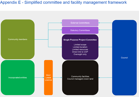
In addition, the current Standard Committee Constitution requires an overhaul for consistency with this framework and to
· Emphasis the operational role as Advisory Committees
· Simplify operational procedures rather than compliance with Council’s Code of Meeting Practice
ARIC recognised that the existing Committees will be dissolved at the 2021 Local Government Elections in accordance with their original appointments and a transitional plan be developed to engage with Committee Members. The actual Advisory Committees will be determined by the incoming Council following the election. Council’s Governance Manager will oversee the implementation of this recommendation if endorsed.
3. ARIC Committee Membership
ARIC recommended Council consider an extension of the current external ARIC Committee independent members
It is agreed that the term of the independent members be extended until such time that the Office of Local Government finalises amendments to the regulatory arrangements for the operation of ARICs. The Committee’s recommendation is amended to reflect this.
|
That the Minutes of the Audit, Risk & Improvement Committee meeting held on 30 March 2021 be noted and the following recommendations be endorsed: Item 3.1 2019/20 NSW Audit Office Final Audit Management Letter That: 1. NSW Audit Office Final Management Letter on the external audit for the year ended 30 June 2020 be received and the management responses with agreed timeframes for addressing all audit issues is endorsed 2. Management should address repeat audit issues from prior audit periods as a matter of priority, preferably by 30 June 2021 Item 3.2 Internal Audit Report – Review of Governance Standards of Council Committees That: 1. The internal audit report on governance standards of Council Committees for current Council term be received and the management responses with agreed timeframes for addressing matters identified be endorsed 2. Committees be dissolved, by default, by the end of current Council term in September 2021 3. A transition plan, with clear responsibilities, be developed to ensure engagement with committee members is undertaken prior to dissolution 4. Progress reports to be provided to ARIC Item 4 Committee Membership That the current external ARIC Committee independent members’ term be extended until such time that the Office of Local Government finalises amendments to the regulatory arrangements for the operation of ARICs |
ATTACHMENTS: a. Audit, Risk & Improvement Committee Minutes - 30 March 202 ⇩
Ordinary Meeting of Council 28 April 2021